
A heat wave over the Southwest will intensify this week, peaking and expanding into the Intermountain West and northern High Plains this weekend. Critical to extremely critical fire weather conditions are forecast from the Northwest and the northern Great Basin this weekend. Particularly Dangerous Situation Red Flag Warnings have been issued. Read More >

| Grady County, OK Tornadoes Prior to 1950 | |||||||||
| # | Date | Time (CST) |
Path Length (miles) |
Path Width (yards) |
F-Scale | Killed | Injured | County | Path |
|---|---|---|---|---|---|---|---|---|---|
| 02/25/1888 | 0 | Grady | Alex | ||||||
| 05/18/1903 | 1730 | 55 | 200 | 0 | Grady/ Canadian/ Oklahoma/ Logan | NW Oklahoma County - NE of Guthrie | |||
| 05/23/1903 | 8 | 0 | Grady | 5 SW Ninnekah | |||||
| 08/05/1917 | 1600 | 1760 | 1 | 4 | Grady | Near Pocasset | |||
| 05/31/1923 | 0000 | 60 | 0 | 0 | Grady | Near Rush Springs | |||
| 04/11/1927 | 1800 | 52 | 500 | 1 | 7 | Caddo/ Grady/ Canadian | Near Alfalfa - near Mustang | ||
| 05/03/1930 | 1710 | 4 | 120 | 0 | 3 | Grady | Near Tuttle | ||
| 05/05/1930 | 2200 | 4 | 150 | 2 | 0 | Grady | Near Rush Springs | ||
| 04/19/1933 | 1900 | 15 | 880 | 2 | 25 | Grady | Agawam - NE of Chickasha | ||
| 05/21/1940 | 1630 | 5 | 200 | 0 | 4 | Grady | N and E of Verden | ||
| 01/26/1944 | 2 | 0 | 0 | Grady | Alex and "Hankins" | ||||
| 05/02/1944 | 1900 | 6 | 100 | 0 | 0 | Grady | S and E of Tuttle | ||
| 05/15/1948 | 2130 | 2 | 1000 | 0 | 0 | Grady | Near Anadarko and Verden | ||
| 04/30/1949 | 1500 | 30 | 250 | 0 | 4 | Comanche/ Grady | NE part of Lawton - southern Grady county | ||
| Grady County, OK Tornadoes (1950-Present*) | |||||||||
| # | Date | Time (CST) |
Path Length (miles) |
Path Width (yards) |
F-Scale | Killed | Injured | County | Path |
| 1 | 04/05/1951 | 1322 | 0.2 | 100 | F2 | 0 | 2 | Grady | Bridge Creek School District (7 NNW Blanchard) |
| 2 | 06/06/1951 | 2350 | 4 | 450 | F2 | 0 | 0 | Grady | Cox City |
| 3 | 05/22/1952 | 2330 | 0.1 | 10 | F1 | 0 | 0 | Grady | southern part of county |
| 4 | 03/13/1953 | 1715 | 24 | 100 | F2 | 0 | 1 | Grady | Rush Springs - 6.5 SW Blanchard |
| 5 | 03/13/1953 | 1819 | 1 | 100 | F3 | 1 | 8 | Grady | Bradley |
| 6 | 04/14/1953 | 1850 | 16 | 440 | F2 | 0 | 0 | Canadian/ Grady | 5 SW Yukon - 8 E Tuttle |
| 7 | 06/19/1953 | 1730 | 6 | 880 | F1 | 0 | 0 | Grady | 5 SW Chickasha - SW edge of Chickasha |
| 8 | 11/18/1953 | 2130 | 0.3 | 10 | F1 | 0 | 0 | Grady | 8 W Minco |
| 9 | 01/05/1955 | 0500 | 0.1 | 10 | F0 | 0 | 0 | Grady | Chickasha |
| 10 | 05/25/1955 | 1800 | 0.1 | 10 | F1 | 0 | 0 | Grady | near Rush Springs |
| 11 | 05/26/1955 | 0230 | 0.1 | 10 | F1 | 0 | 0 | Grady | near Chickasha |
| 12 | 04/28/1956 | 1420 | 35 | 10 | F1 | 0 | 0 | Grady/ McClain/ Cleveland | 5 S Chickasha - 3 E Norman |
| 13 | 04/21/1958 | 1535 | 0.1 | 10 | F0 | 0 | 0 | Grady | 10 N Verden |
| 14 | 04/21/1958 | 1605 | 0.1 | 10 | F0 | 0 | 0 | Grady | Just S of Chickasha |
| 15 | 05/22/1959 | 0220 | 0.1 | 10 | F2 | 0 | 0 | Grady | 5 W Minco |
| 16 | 04/28/1960 | 1945 | 4 | 200 | F2 | 0 | 1 | Grady | 2 S Pocassett |
| 17 | 04/28/1960 | 1945 | 3 | 200 | F2 | 0 | 0 | Grady | 2 NE Amber |
| 18 | 04/28/1960 | 1945 | 4 | 200 | F3 | 0 | 2 | Grady | 1.5 N- 3 ENE Pocassett |
| 19 | 04/28/1960 | 1945 | 2 | 300 | F2 | 0 | 0 | Grady | Pocassett |
| 20 | 04/28/1960 | 2050 | 1.5 | 200 | F3 | 0 | 1 | Grady | Tuttle |
| 21 | 05/19/1960 | 1600 | 0.1 | 10 | F1 | 0 | 0 | Caddo/ Grady | N of Verden - near Dutton |
| 22 | 04/30/1961 | 1845 | 2 | 77 | F3 | 0 | 2 | Grady | 2 N Minco |
| 23 | 05/16/1961 | 2257 | 0.1 | 10 | F0 | 0 | 0 | Grady | Near Verden |
| 24 | 04/07/1965 | 2350 | 22 | 440 | F2 | 0 | 2 | Caddo/ Grady | Anadarko - 3 W Amber |
| 25 | 04/08/1965 | 0020 | 1 | 10 | F2 | 0 | 0 | Grady | 3 S Tuttle |
| 26 | 04/08/1965 | 0020 | 1 | 10 | F2 | 0 | 0 | Grady | 4 S Tuttle |
| 27 | 04/08/1965 | 0100 | 0.3 | 10 | F1 | 0 | 0 | Grady | 4 S Tuttle |
| 28 | 05/26/1965 | 0235 | 0.1 | 10 | F1 | 0 | 0 | Grady | Minco |
| 29 | 04/19/1968 | 1545 | 0.1 | 10 | F1 | 0 | 0 | Grady | 5 NNW Blanchard |
| 30 | 06/05/1968 | 1818 | 0.1 | 10 | F0 | 0 | 0 | Grady | 3 SE Verden |
| 31 | 04/26/1969 | 1700 | 10 | 10 | F1 | 0 | 0 | Grady | Ninnekah - Tabler |
| 32 | 05/03/1969 | 1400 | 0.1 | 10 | F1 | 0 | 0 | Grady | Near Verden |
| 33 | 04/30/1970 | 0045 | 32 | 440 | F1 | 0 | 0 | Grady/ Canadian/ Oklahoma | 6 WNW Minco - northwest Oklahoma City - 5 NW The Village |
| 34 | 04/30/1970 | 0100 | 47 | 500 | F2 | 0 | 6 | Grady/ Canadian/ Oklahoma | 4 NW Pocasset - Mustang - Oklahoma City - 2 W Arcadia |
| 35 | 06/20/1970 | 1653 | 0.1 | 10 | F0 | 0 | 0 | Grady | NW of Tuttle |
| 36 | 06/18/1973 | 1900 | 4 | 50 | F1 | 0 | 1 | Grady | S of Rush Springs |
| 37 | 04/20/1974 | 1500 | 64 | 100 | F3 | 0 | 3 | Grady/ Canadian/ Oklahoma/ Lincoln | SW of Minco - 2 SE Mustang - S Oklahoma City - Del City - Midlothian |
| 38 | 03/02/1977 | 1630 | 5 | 100 | F2 | 0 | 0 | Grady | 5 NE- 9 NE Alex |
| 39 | 03/02/1977 | 1630 | 6 | 100 | F1 | 0 | 0 | Grady/ McClain | Near Blanchard |
| 40 | 05/20/1977 | 1543 | 3 | 90 | F1 | 0 | 0 | Grady | Chickasha (near Airport) |
| 41 | 04/30/1981 | 2000 | 32 | 10 | F1 | 0 | 0 | Caddo/ Grady | near Gracemont - Anadarko - near Rush Springs |
| 42 | 04/30/1981 | 2015 | 29 | 10 | F2 | 1 | 4 | Grady | Near Minco - Chickasha - S of Rush Springs [not continuous] |
| 43 | 03/03/1983 | 1300 | 0.1 | 20 | F1 | 0 | 0 | Grady | 6 W Newcastle |
| 44 | 05/13/1983 | 2245 | 0.1 | 50 | F1 | 0 | 0 | Grady | 6 N Chickasha |
| 45 | 06/28/1983 | 0045 | 0.1 | 10 | F0 | 0 | 0 | Grady | ~4 S Rush Springs |
| 46 | 03/13/1990 | 1644-1737 | 28 | 200 | F2 | 0 | 1 | Grady/ McClain/ Cleveland | 1 W Bradley- Washington- Noble- 5 NE Noble |
| 47 | 03/29/1993 | 2152-2202 | 5 | 33 | F1 | 0 | 0 | Grady/ McClain | 4 E Alex- 3 W Criner |
| 48 | 05/25/1997 | 1514-1524 | 3 | 73 | F1 | 0 | 0 | Grady | 3 NE Tabler - 2.5 SSW Middleberg |
| 49 | 10/04/1998 | 1754-1755 | 1.5 | 200 | F2 | 0 | 0 | Grady | 9 WSW - 7.5 WSW Ninnekah |
| 50 | 10/04/1998 | 1915-1921 | 5 | 80 | F2 | 0 | 0 | Grady/ McClain | 4 NW Blanchard - 2 SSW Newcastle |
| 51 | 05/03/1999 | 1646-1710 | 9 | 880 | F3 | 0 | 4 | Caddo/ Grady | 2 WSW Laverty - 4 S Verden - 2.5 WNW Downtown Chickasha |
| 52 | 05/03/1999 | 1707-1708 | 1 | 75 | F0 | 0 | 0 | Grady | 5 W Downtown Chickasha |
| 53 | 05/03/1999 | 1712-1721 | 4 | 500 | F2 | 0 | 4 | Grady | 2.5 NW Downtown Chickasha - Chickasha Airport (NW edge of Chickasha) - 4 NNE Downtown Chickasha |
| 54 | 05/03/1999 | 1726-1848 | 37 | 1760 | F5 | 36 | 583 | Grady/ McClain/ Cleveland/ Oklahoma | 2 SSW Amber - far N Newcastle - SW Oklahoma City - N Moore - S Del City - W Midwest City |
| 55 | 05/03/1999 | 1837-1840 | 2 | 300 | F1 | 0 | 0 | Grady | 8 WSW - 6 WSW Minco |
| 56 | 05/03/1999 | 1847-1900 | 4 | 60 | F1 | 0 | 0 | Grady | 5 W - 4 NW Minco |
| 57 | 05/03/1999 | 1855 | 0.1 | 50 | F1 | 0 | 0 | Grady | 5 SW Minco |
| 58 | 05/04/2001 | 1805-1806 | 0.2 | 25 | F0 | 0 | 0 | Grady | 0.5 E Chickasha |
| 59 | 05/04/2001 | 1820-1824 | 0.7 | 50 | F0 | 0 | 0 | Grady | 2 NNE - 3 N Amber |
| 60 | 05/09/2003 | 2017-2020 | 1.2 | 50 | F0 | 0 | 0 | Caddo/ Grady | 1.4 NE - 2.5 ENE Cogar |
| 61 | 05/08/2007 | 2154-2158 | 1.5 | 30 | EF1 | 0 | 0 | Grady | 2.7 SW - 2.6 W Minco |
| 62 | 08/18/2007 | 1944-1948 | 2 | 30 | EF1 | 0 | 0 | Grady | 2.5 SSW Norge - 1.8 E Laverty |
| 63 | 08/19/2007 | 0132-0138 | 7 | 75 | EF1 | 0 | 0 | Grady/ Canadian | 1 ESE Minco - 1 N Union City |
| 64 | 05/10/2010 | 1620-1627 | 6 | 700 | EF1 | 0 | 0 | Stephens/ Grady | 3 NE Bray - 2.5 ESE Cox City |
| 65 | 05/24/2011 | 1606-1701 | 33 | 880 | EF4 | 1 | 48 | Grady/ McClain/ Cleveland | 2 S Chickasha - Oklahoma City (near SW 149th/Portland) |
| 66 | 05/24/2011 | 1626-1705 | 23 | 880 | EF4 | 0 | 61 | Grady/ McClain | 2 W Bradley - 1 W Goldsby |
| 67 | 05/08/2013 | 1918 | 0.1 | 50 | EF0 | 0 | 0 | Grady | 4 SE Minco |
| 68 | 05/31/2013 | 1845 | 0.2 | 50 | EF0 | 0 | 0 | Grady | 2 NNE Tuttle |
| 69 | 05/06/2015 | 1533-1626 | 10 | 1500 | EF3 | 0 | 0 | Grady | 4.5 E Amber - 4 NNE Bridge Creek |
| 70 | 05/06/2015 | 1548 | 0.3 | 50 | EF0 | 0 | 0 | Grady | 5 ENE Amber |
| 71 | 05/06/2015 | 1849-1851 | 0.5 | 40 | EF0 | 0 | 0 | Grady | 3 SE Tuttle |
| 72 | 05/06/2015 | 1911-1921 | 4 | 200 | EF0 | 0 | 0 | Grady | 4 ENE Tuttle - 2 NE Bridge Creek |
| 73 | 05/23/2015 | 1612-1632 | 6 | 500 | EF1 | 0 | 0 | Grady | 3 W - 4 NNE Pocasset |
| 74 | 04/29/2016 | 1503-1522 | 12 | 1000 | EF1 | 0 | 0 | Grady | 8 WSW - 4 ENE Ninnekah |
| 75 | 05/31/2016 | 1628-1632 | 0.5 | 30 | EF? | 0 | 0 | Grady | 4 N Pocasset |
| 76 | 05/31/2016 | 1628-1634 | 0.7 | 30 | EF? | 0 | 0 | Grady | 3 NW Pocasset |
| 77 | 05/31/2016 | 1628-1635 | 0.7 | 30 | EF? | 0 | 0 | Grady | 4 W - 4 WNW Pocasset |
| 78 | 05/02/2018 | 1855-1906 | 10 | 400 | EF1 | 0 | 0 | Grady | 4 SSW Acme - 2 SSE Agawam |
| 79 | 05/02/2018 | 1858-1906 | 6 | 100 | EF1 | 0 | 0 | Grady | 4 WSW - 3 SSE Amber |
| 80 | 05/02/2018 | 1905-1906 | 0.4 | 25 | EF1 | 0 | 0 | Grady | 1 E Amber |
| 81 | 04/21/2020 | 2228-2230 | 0.3 | 100 | EF1 | 0 | 0 | Comanche/ Grady | 7 SSW Acme |
| 82 | 06/13/2021 | 1501-1502 | 0.5 | 10 | EF0 | 0 | 0 | Grady | 4 W Tuttle |
| 83 | 10/10/2021 | 1802-1805 | 1.8 | 50 | EF? | 0 | 0 | Caddo/ Grady | 3 SW - 1 SSE Verden |
| 84 | 10/10/2021 | 1816 | 0.2 | 50 | EF? | 0 | 0 | Grady | 3 N Chickasha |
| 85 | 04/23/2022 | 1801-1810 | 4 | 30 | EF0 | 0 | 0 | Grady | 2.5 WNW - 2.4 NNE Tuttle |
| 86 | 12/13/2022 | 0451-0452 | 0.6 | 50 | EF2 | 0 | 0 | Grady | 1 NNW Cox City |
| 87 | 02/26/2023 | 2052-2053 | 0.2 | 75 | EF0 | 0 | 0 | Grady | 4 WSW Minco |
| 88 | 02/26/2023 | 2057-2107 | 11 | 200 | EF1 | 0 | 0 | Grady/ Canadian | 3 W Tuttle - far southwest OKC - 4 WNW Mustang |
| 89 | 04/19/2023 | 1820-1826 | 3 | 200 | EF1 | 0 | 0 | Grady/ McClain | 3 SE Middleberg - 3 NNW Dibble |
| 90 | 05/11/2023 | 1724-1726 | 1 | 20 | EF0 | 0 | 0 | Grady | 1 N Norge |
| 91 | 05/11/2023 | 1757-1808 | 2.8 | 50 | EF? | 0 | 0 | Grady | 4 S - 2 SE Tuttle |
| 92 | 05/11/2023 | 1836-1838 | 0.4 | 30 | EF0 | 0 | 0 | Grady/ McClain | 3.5 SE Bridge Creek |
| 93 | 05/11/2023 | 1845-1845 | 0.2 | 20 | EF? | 0 | 0 | Grady | 2 NNW Rush Springs |
| 94 | 05/11/2023 | 1904-1907 | 1.5 | 75 | EF0 | 0 | 0 | Grady | 4.5 SW - 3.5 SSW Dibble |
| 95 | 05/13/2023 | 1418-1418 | 0.1 | 20 | EF0 | 0 | 0 | Grady | 3 WNW Chickasha |
| 96 | 04/27/2024 | 1953-2001 | 4.4 | 225 | EF1 | 0 | 0 | McClain/ Grady | 3 ENE Bradley - 6 SSW Dibble |
| Date | Time (CST) |
Path Length (miles) |
Path Width (yards) |
F-Scale | Killed | Injured | County | Path | |
|---|---|---|---|---|---|---|---|---|---|
| 04/05/1951 | 1322 | 0.2 | 100 | F2 | 0 | 2 | Grady | Bridge Creek School District (7 NNW Blanchard) | |
|
A tornado demolished the Bridge Creek grade school and high school buildings. Of the 120 people taking shelter inside the two brick buildings, only two persons, a teacher and a 16-year-old student required medical treatment. |
|||||||||
| 03/13/1953 | 1715 | 24 | 100 | F2 | 0 | 1 | Grady | Rush Springs - 6.5 SW Blanchard | |
|
This tornado touched down at 5:15 pm CST in the Rush Springs area. A total of 76 houses in the southern and eastern sections of Rush Springs were damaged. A Quonset barn and gas station on the southern edge of Rush Springs were destroyed. One man was slightly injured when he was carried 300 feet by the tornado. Damages from the tornado were estimated at $45,000 and damages from accompanying hail totaled $5,000. |
|||||||||
| 03/13/1953 | 1819 | 1.0 | 100 | F3 | 1 | 8 | Grady | Bradley | |
|
This tornado struck the town of Bradley, OK in Grady County at 6:19 pm CST, killing one person and injuring another eight people. A general store/post office was demolished in the southwest edge of Bradley along OK State Highway 19. The storekeeper had just closed the business previously due to a tornado warning. Six homes and 4 businesses were leveled by the tornado while 5 or more houses were damaged. Four other buildings in the business district were damaged, and several automobiles were destroyed. The Bradley High School gymnasium was unroofed by the tornado and the main high school building was damaged. Damages were estimated at $250,000 or greater. |
|||||||||
| 04/28/1960 | 1945 | 4 | 200 | F2 | 0 | 1 | Grady | 2 S Pocassett | |
|
An Oklahoma State Highway Patrolman sighted a tornado moving eastward across Pocasset. Outbuildings, roofs, and trees were damaged within the town. The tornado lifted before reaching the main part of the community. Hail up to the size of baseballs occurred in in the area, breaking many windows and producing other damage at many homes. Nearly every house in the town received damage from either the tornado or hail. |
|||||||||
| 04/28/1960 | 1945 | 4 | 200 | F3 | 0 | 2 | Grady | 1.5 N- 3 ENE Pocassett | |
|
A tornado touched down at 7:45 pm CST 1.5 miles north of Pocasset and moved eastward of 4 miles. Three farmsteads were nearly destroyed along the tornado's path. Two injuries resulted when the western half of a house was demolished. Hail to the size of golf balls caused up to 50% crop damage in sporadic areas. |
|||||||||
| 04/28/1960 | 2050 | 1.5 | 200 | F3 | 0 | 1 | Grady | Tuttle | |
|
A tornado hit Tuttle and some surrounding farmsteads as it moved to the east-northeast through the southern part of Tuttle. A woman was injured when her house was destroyed. About 4 houses were destroyed and another 45-50 houses were damaged. The roof of a grade school was damaged and the eastern end of the high school's gymnasium was ripped apart. Other grade school buildings were destroyed. Two cotton gins and part of a grain elevator were damaged. The city's water supply was also cut off. |
|||||||||
| 04/30/1961 | 1845 | 2 | 77 | F3 | 0 | 2 | Grady | 2 N Minco | |
|
A house and automobile were destroyed and the occupants of the home were slightly injured at a location 2 miles north of Minco. Four other farmsteads were damaged along the tornado's path. |
|||||||||
| 04/07/1965 | 2350 | 22 | 440 | F2 | 0 | 2 | Caddo/ Grady | Anadarko - 3 W Amber | |
|
A tornado touched in Caddo County in the northwest section of Anadarko and moved east-northeast across the northern part of the city, destroying a large freight dock. A bus barn and 7 buses within were damaged. A 120-patient rest home was damaged while several homes in the northern part of Anadarko were destroyed. In addition, several cars were overturned, trees were ripped from the ground, a police communications tower was toppled, and telephone services were knocked out. Two people were injured as the tornado moved east-northeastward past Verden and destroyed 4 homes and 4 barns. One man was injured near Anadarko, and one woman was injured when the wall of a storm cellar caved in and trapped one of her legs near Verden. The tornado also produced damage at Lake Chickasha, destroying 3 mobile homes and heavily damaging 2 other mobile homes. A farmer observed the tornado as it lifted 4.5 north-northeast of Verden. Either the same tornado or a new tornado produced damage 3 miles west of Amber where a large chicken house was demolished and the south side of a barn was torn away. |
|||||||||
| 04/30/1970 | 0100 | 47 | 500 | F2 | 0 | 6 | Grady/ Canadian/ Oklahoma | 4 NW Pocasset - Mustang - Oklahoma City - 2 W Arcadia | |
|
The first report of damage from a tornado was located 4 miles northwest of Pocasset in Grady County, or 25 miles southwest of Oklahoma City. The tornado moved along a northeastward path through parts of Canadian and Oklahoma counties, and damaged was last reported 2 miles west of Arcadia. Only 2 or 3 people reported seeing the funnel, but a number of persons heard a loud noise, like that made by a jet engine. In several areas roofs or buildings were moved at a right angle to the path of the storm, indicating a rotating column of air. Most of the damage occurred at Mustang in Canadian County, located just southwest of Oklahoma City, and along a path up to a half mile wide from the southwest corner of Oklahoma City to the northeast corner of the city. A farmstead northwest of Pocasset received $10,000 in damages, and there was extensive damage to a home and several outbuildings 2 miles west of Arcadia. Two semi-trailer trucks were blown off the road and turn over on their sides along the westbound U.S. Interstate Highway I-40 lanes as the trucks were entering the Oklahoma City limits. At Mustang, damages were estimated at $500,000 and were confined mainly to a shopping center and the city hall in the north part of Mustang. About 3 miles northeast of Mustang, a school building was extensively damaged and had most of its windows blown out. One mile west of Mustang, wind equipment belonging to the National Severe Storms Laboratory (NSSL) recorded a wind speed of 110 mph. About 7 miles southwest of Mustang, a NSSL rain gauge measure 5 inches of rain. In Oklahoma City, the damage was estimated at $6.3 million. Damage occurred to 1,473 homes, 293 businesses, 8 schools, 12 churches, and 300 signs. Southwestern Bell Telephone Company officials reported 30,000 telephones out of service, primarily in northwest Oklahoma City and Mustang. Oklahoma Gas and Electric officials reported that 215 utility poles were downed. It is possible that several tornadoes were produced by the parent supercell thunderstorm instead of a single, long-track tornado. |
|||||||||
| 06/18/1973 | 1900 | 4 | 50 | F1 | 0 | 1 | Grady | S of Rush Springs | |
|
A tornado damaged a mobile home south of Rush Springs where one woman was injured. A number of trees were downed along the 4-mile path. A fruit stand in the area was also damaged. |
|||||||||
| 04/20/1974 | 1500 | 64 | 100 | F3 | 0 | 3 | Grady/ Canadian/ Oklahoma/ Lincoln | SW of Minco - 2 SE Mustang - S Oklahoma City - Del City - Midlothian | |
|
A funnel cloud was observed 3 miles southwest of Minco in Grady County at about 3:00 pm CST. The funnel touched down about 2 miles southwest of Mustang at 3:28 pm CST and periodically lifted and touched the ground again at it moved to the east-northeast at 30 mph. This tornado dissipated in Lincoln County at 5:30 pm CST. The tornado passed about a mile south of the NWS forecast office located near the Will Rogers World Airport in Oklahoma City. Wind gusts of 66 mph along with 2-inch diameter hail were observed at the forecast office. A major portion of the reported damage occurred as the storm moved through the southern Oklahoma City and Del City areas. There was extensive damage to homes in that area as several houses were unroofed. A total of 3 injuries were reported in the great Oklahoma City area. Fortunately, none of the injuries were serious. As the continued moving to the east-northeast through eastern Oklahoma County, the next report of damage was 3 miles northwest of Harrah where several farm buildings were destroyed. Several more farm buildings were destroyed in the Midlothian area. If more data had been available at the time, it is possible that 2-3 tornadoes may have occurred with one tornado dissipating and another tornado forming near the end point of the previous tornado. However, with the data that was available at the time, it appeared that one long-track tornado occurred. |
|||||||||
| 04/30/1981 | 2015 | 29 | 5 | F2 | 1 | 4 | Grady | Near Minco - Chickasha - S of Rush Springs (* not a continuous track) | |
|
This tornado touched down near Minco, OK and moved south with an intermittent path to Chickasha, OK and Rush Springs, OK before lifting near Marlow, OK. Near Rush Springs, a four-month-old infant was killed and two adults were injured when the tornado destroyed a mobile home. Approximately $250,000 worth of damage occurred to a warehouse in Chickasha. |
|||||||||
| 03/13/1990 | 1644-1737 | 28 | 200 | F2 | 0 | 1 | Grady/ McClain/ Cleveland | 1 W Bradley- Washington- Noble- 5 NE Noble | |
|
An outbreak of severe thunderstorms and tornadoes occurred during the afternoon and evening of March 13th and the early morning hours of March 14th. Many reports of large hail up to the size of softballs were received. A total of 10 tornadoes occurred in Oklahoma. A strong tornado touched down 1 mile west of Bradley and moved northeast before dissipating 5 miles northeast of Noble. Near Bradley, 2 mobile homes were destroyed, while several homes and 3 barns were damaged. In McClain County, the damage was intermittent from 5 miles west of Criner to U.S. Interstate Highway I-35 southeast of Goldsby. At least 8 mobile homes and several outbuildings were destroyed. In Washington, the second story of a home was destroyed and one injury occurred to a woman in a mobile home. In Cleveland County at Noble, the damage was extensive. An apartment building lost part of its roof, and a mobile home was overturned. Several tractor semi-trailers were overturned at a warehouse. Numerous homes sustained roof and other structural damage in the Sky Ridge and Forest Hills subdivisions. The Noble High School stadium press box was destroyed, several light poles were snapped, and the scoreboard was demolished. Total damage was estimated between $750,000 and $1 million. |
|||||||||
| 05/03/1999 | 1646-1710 | 9 | 880 | F3 | 0 | 4 | Caddo/ Grady | 2 WSW Laverty - 4 S Verden - 2.5 WNW Downtown Chickasha | |
|
This tornado developed about 3 miles north-northeast of Cement (or 2 miles west-southwest of Laverty) near the Caddo/Grady County border, and quickly intensified to a strong tornado with associated damage rated at the high end of the F3 scale. The tornado tracked northeast for 9 miles before dissipating 2.5 miles west-northwest of downtown Chickasha. Two homes had just a few interior walls standing (F3), one located near U.S. Highway 62 on the northwest side of Chickasha, and several wooden high tension power lines were downed. Several persons were injured south of Verden near the Caddo/Grady County border. |
|||||||||
| 05/03/1999 | 1712-1721 | 4 | 500 | F2 | 0 | 4 | Grady | 2.5 NW Downtown Chickasha - Chickasha Airport (NW edge of Chickasha) - 4 NNE Downtown Chickasha | |
|
This tornado developed 2.5 miles northwest of downtown Chickasha just north of U.S. Highway 62, and tracked northeast, striking the Chickasha Municipal Airport, resulting in high-end F2 damage to two hangar buildings and destroying several aircraft. An aircraft wing, believed to have originated from this airport was eventually carried airborne approximately 45 miles and dropped in southwest Oklahoma City. Approximately 20 mobile homes near the airport were either damaged or destroyed with several persons injured. The tornado then crossed U.S. Highway 81 about 2 miles north of its intersection with U.S. Highway 62 destroying a large building, then dissipated 4 miles north-northeast of downtown Chickasha. |
|||||||||
| 05/03/1999 | 1726-1848 | 38 | 1760 | F5 | 36 | 583 | Grady/ McClain/ Cleveland/ Oklahoma | 2 SSW Amber - far N Newcastle - SW Oklahoma City - N Moore-S Del City-W Midwest City | |
|
This violent, long-lived tornado was the most infamous of nearly 60 tornadoes that struck central Oklahoma during an unprecedented outbreak on this Monday afternoon and evening of May 3, 1999. The tornado was the 9th of 14 tornadoes produced by a supercell thunderstorm during the tornado outbreak. It formed around 5:26 pm CST about 2 miles south-southwest of Amber, OK, and grew rapidly to monstrous proportions as it headed to the northeast, paralleling U.S. Interstate Highway I-44. It moved across Bridge Creek and rural parts of northwest Newcastle, OK, causing continuous F4 and sporadic F5 damage. The tornado was estimated to be a mile in diameter in this area. It weakened to F2/F3 intensity and narrowed to less than 1/4 mile in width as it crossed U.S. Interstate Highway I-44 and the Canadian River northeast of Newcastle and entered far south Oklahoma City, OK southwest of 149th Street and May Avenue around 6:12 pm CST. But it regained F4/F5 intensity and widened again to 1/2 to occasionally 3/4 mile as it moved northeast across south Oklahoma City, entering Moore, OK just west and north of 12th Street and Santa Fe Avenue. Still moving northeast and still producing F4 and occasional F5 damage, it crossed U.S. Interstate Highway I-35 at the Shields Boulevard junction and moved into northeast Moore, at which point it weakened slightly to F3/sporadic F4 intensity and began a gradual turn to the left. This turn took the tornado more to the north-northeast as it crossed I-240 between Bryant Avenue and Sunnylane Road. It crossed southeastern Oklahoma City and entered Del City, OK as an F4 tornado, width 1/3 to 1/2 mile, along SE 44th Street between Sunnylane and Sooner Roads, and continued north-northeast to the northwestern part of Tinker Air Force Base, near SE 29th Street and Sooner Road. Continuing to turn slowly, it moved almost due north but maintained F4 intensity as it crossed U.S. Interstate Highway I-40 just east of Sooner Road and continued north to between SE 15th Street and Reno Avenue. The tornado then weakened rapidly to F0/F1 intensity as it crossed Reno Avenue, and at 6:48 pm CST dissipated about 3 blocks north of Reno Avenue between Sooner Road and Air Depot Boulevard. Totals from this tornado include 36 direct fatalities (12 in Bridge Creek, 1 in Newcastle, 9 in southern/southeastern Oklahoma City, 5 in Moore, 6 in Del City, and 3 in Midwest City), 5 indirect fatalities during or shortly after the tornado, 583 direct injuries, numerous indirect injuries (too many to count), 1800 homes destroyed, and 2500 homes damaged. The tornado was also the 100th tornado to strike the Oklahoma City area since 1890. Total damage was estimated at $1 billion. |
|||||||||
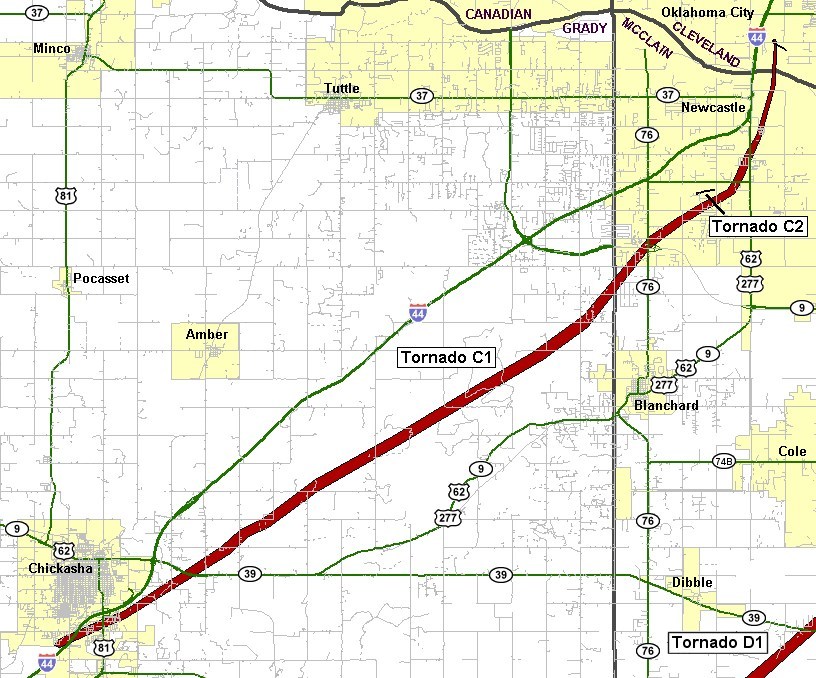
| 05/24/2011 | 1606-1701 | 33 | 880 | EF4 | 1 | 48 | Grady/ McClain/ Cleveland | 2 S Chickasha - SW Oklahoma City (near SW 149th and Portland) | |
|
This tornado formed on the south side of Chickasha in Grady County, quickly doing EF-2 damage. Mobile homes were damaged and destroyed, trees were uprooted or destroyed, outbuildings were destroyed, and many buildings lost significant portions of their roofs. One fatality occurred as a mobile home was destroyed in the south portion of Chickasha. As the tornado moved northeast of Chickasha, it gained significant strength, with several areas receiving EF-4 damage. Well-built homes were destroyed. Trees were debarked with only stumps remaining. Cars were thrown hundreds of feet. Almost continuous EF-3/occasional EF-4 damage occurred northeast until it crossed into McClain County, 1.5 miles south of OK State Highway 9. The tornado was probably at its strongest as it neared/crossed the Grady/McClain County line. Wind speeds there were estimated near 200 mph in this area. Significant damage continued as the violent tornado moved over the McClain County border. This may have been the strongest portion of this tornado, with wind speeds near 200 mph. Well-built homes were destroyed, with some cleaned off of their foundation. A concrete dome home was severely damage, mainly by the flying debris. Trees were debarked or destroyed. Very little was left standing for the first few miles into McClain County. Fairly consistent EF-3, with brief periods of EF-4 damage occurred as the tornado approached and then crossed OK State Highway 9, near the OK State Highway 76 junction. The tornado began to weaken as it moved toward the Cleveland County border, with mainly trees and power poles/lines snapped. The tornado continued into Cleveland County and where some minor tree/power pole/power line damage occurred. A few barns and outbuilding also sustained minor damage east of U.S. Interstate Highway I-44. The tornado dissipated just north of the Canadian River. The tornado traveled along a path length of 32 miles through three counties in just under an hour, Peak wind speeds were estimated just under 200 mph. |
|||||||||
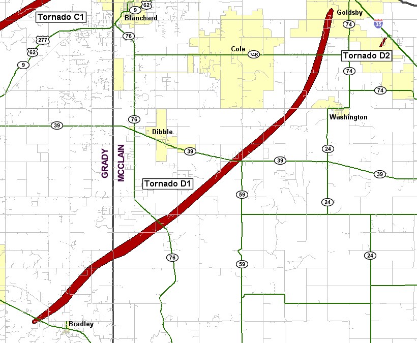
| 05/24/2011 | 1626-1705 | 23 | 880 | EF4 | 0 | 61 | Grady/ McClain | 2 W Bradley - 1 W Goldsby | |
|
This violent tornado developed west of Bradley in Grady County, downing tree limbs as it moved northeast. The tornado began to increase in intensity, producing EF-3 damage, as it approached McClain County. Although the damage was confined to trees, the severity of the damage became more intense along the path. Trees were snapped at the bases, or debarked altogether. The tornado was several hundred yards wide as it neared the Grady/McClain County line. Luckily, very few structures were in the path. Widespread tree damage and ground scouring was ongoing as the tornado crossed into McClain County. As the tornado crossed OK State Highway 76, even more intense damage occurred. EF-4 damage was surveyed at several locations. Several homes were reduced to a pile of rubble, or were wiped clean off of their foundations. Automobiles were mangled and almost unrecognizable. The tornado weakened and narrowed as it crossed CR 410. Even though the tornado had weakened, it still produced EF-2 to EF-3 damage as it approached OK State Highway 39. The tornado increased in intensity once again near OK State Highway 39, with EF-4 damage occurring in a second area along the path. Well-constructed homes were destroyed, with several wiped clean off of their foundations. This also began a longer streak of higher end damage, with EF-3 to EF-4 damage produced by the tornado until it crossed OK State Highway 74B, west of High Avenue. Equally devastating destruction occurred over the areas of EF-4 damage. The tornado lifted west of Goldsby with some EF-3 damage still occurring prior to lifting. It should be noted that this tornado had estimated winds up to 200 mph at times, falling just short of the damage indicator for an EF-5 tornado. |
|||||||||
Records taken from the Storm Prediction Center archive data, "Storm Data", and data from the National Weather Service office in Norman. Data modified as described in NOAA Tech Memo NWS SR-209 (Speheger, D., 2001: "Corrections to the Historic Tornado Database").
Historic data, especially before 1950, are likely incomplete.

