Overview
|
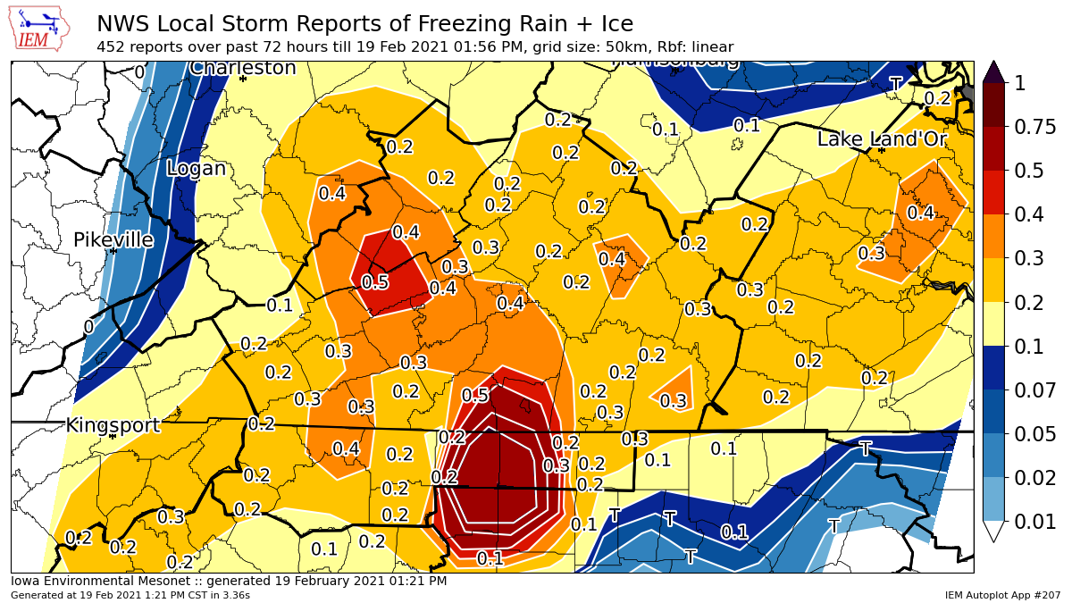
A low pressure system brought a wintry mix to the area beginning after midnight Wednesday night Feb 18th ending by midday Thursday. Most received sleet and freezing rain, with portions of the NC and VA piedmont into the New River Valley getting the most ice. |
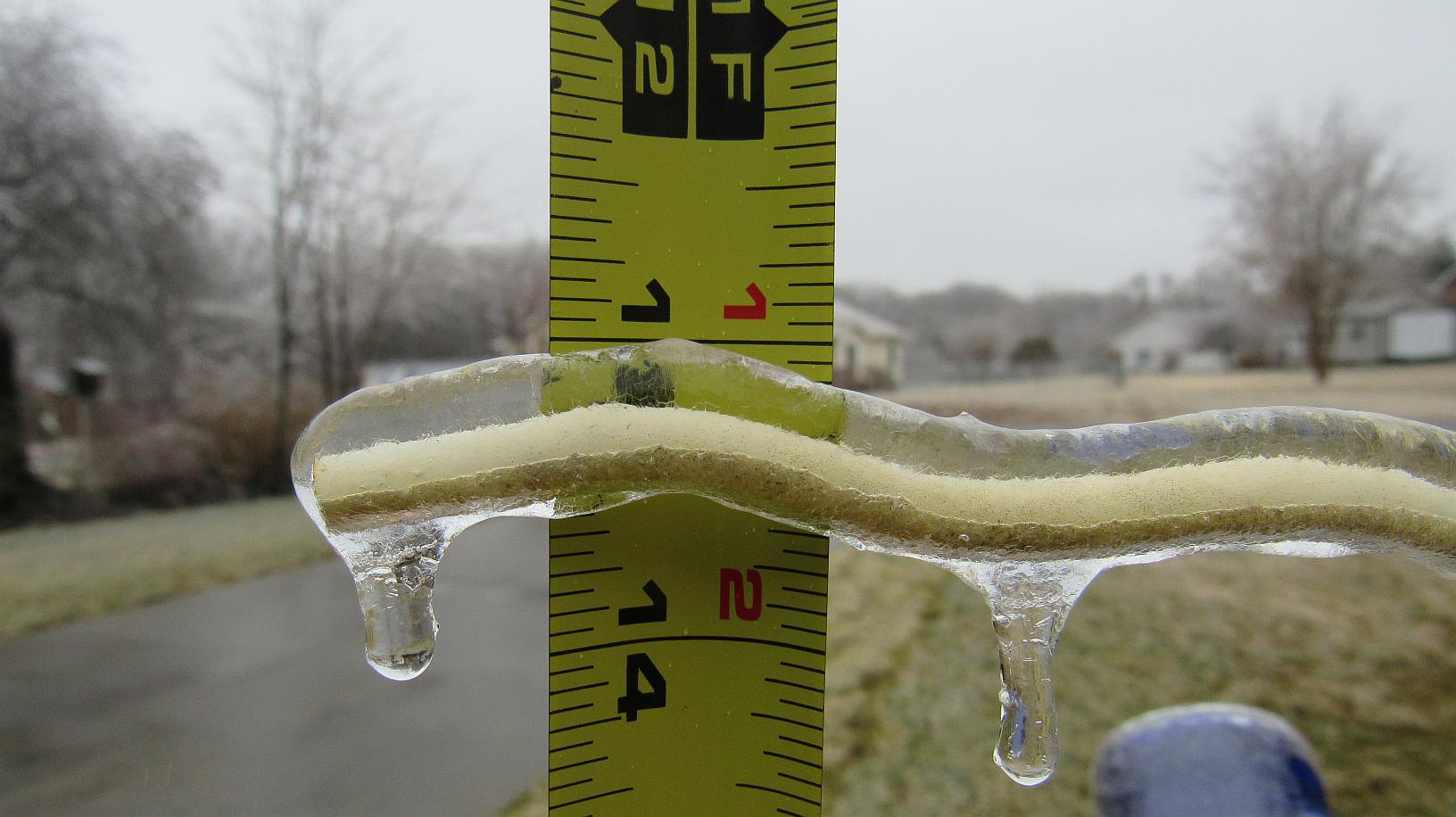
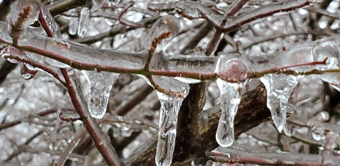
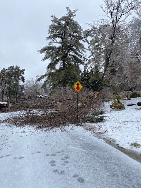
 Caption |
 |
 |
 |
| King, NC Ice (credit: Jeff Poplin) |
Willis, VA Ice (credit: Susanna Moore) |
Blacksburg, VA tree damage (credit: Hager-Smith) |
Snow/Ice
...FREEZING RAIN REPORTS...

Location                     Amount    Time/Date       Provider

...North Carolina...

...Alleghany County...
2 SSE Glade Valley           0.40 in   1000 AM 02/18   Public
3 NE Sparta                  0.33 in   0910 AM 02/18   Trained Spotter
2 E Sparta                   0.25 in   1030 AM 02/18   Trained Spotter
1 W Piney Creek              0.15 in   0715 AM 02/18   Trained Spotter

...Ashe County...
3 ENE Glendale Springs       0.25 in   0955 AM 02/18   Trained Spotter
2 NW Nella                   0.25 in   0900 AM 02/18   Trained Spotter
1 ESE West Jefferson          0.15 in   0930 AM 02/18   Public
Ashland                      0.13 in   0730 AM 02/18   Trained Spotter
3 WSW Grassy Creek           0.10 in   1015 AM 02/18   Trained Spotter
3 SE Fleetwood               0.10 in   0945 AM 02/18   Trained Spotter
5 WSW Scottville             0.10 in   0830 AM 02/18   Trained Spotter
2 NW Wagoner                 0.10 in   0700 AM 02/18   CO-OP Observer
1 E Shatley Springs          0.05 in   0727 AM 02/18   Public

...Caswell County...
Semora                       0.30 in   0810 AM 02/18   Public
4 ESE Quick                  0.25 in   1255 PM 02/18   Public
4 WSW Jericho                0.25 in   0833 AM 02/18   Trained Spotter

...Rockingham County...
1 NNE Reidsville             0.30 in   1100 AM 02/18   Public
3 SW Mayfield                 0.25 in   1100 AM 02/18   Trained Spotter
3 SW Eden                    0.15 in   1100 AM 02/18   Trained Spotter
1 NE Madison                 0.10 in   0345 AM 02/18   Public

...Stokes County...
Lawsonville                  0.30 in   0930 AM 02/18   Public
2 SSW Capella                0.25 in   0130 PM 02/18   Public
2 SSE Collinstown            0.25 in   1000 AM 02/18   Public
2 NW King                    0.25 in   0940 AM 02/18   Trained Spotter

...Surry County...
2 NNW Toast                  0.25 in   1107 AM 02/18   Trained Spotter
3 NE Dobson                  0.25 in   1100 AM 02/18   Trained Spotter
3 SE Woodville               0.15 in   1100 AM 02/18   Trained Spotter
2 W Bottom                   0.15 in   0900 AM 02/18   Public
3 NNW Rockford               0.10 in   1100 AM 02/18   Trained Spotter
Low Gap                      0.10 in   0230 AM 02/18   Public

...Watauga County...
1 NNW Todd                   0.25 in   1030 AM 02/18   Trained Spotter
Blowing Rock                 0.20 in   1100 AM 02/18   Trained Spotter
2 SSE Boone                  0.20 in   0815 AM 02/18   Other Federal
2 NE Aho                     0.13 in   0901 AM 02/18   Trained Spotter
2 NNW Boone                  0.10 in   1058 AM 02/18
2 NE Rominger                0.10 in   0910 AM 02/18   Trained Spotter
1 N Silverstone              0.10 in   0900 AM 02/18   Trained Spotter
4 SSE Deep Gap               0.10 in   0830 AM 02/18   Trained Spotter
1 ENE Boone                  0.10 in   0700 AM 02/18   CO-OP Observer
Boone                        0.10 in   0515 AM 02/18   Emergency Mngr
1 NNW Beech Mountain         0.05 in   0817 AM 02/18   Trained Spotter

...Wilkes County...
2 NNW Benham                 0.25 in   1000 AM 02/18   Trained Spotter
3 SE North Wilkesboro        0.15 in   1028 AM 02/18   Trained Spotter
2 NNW Mulberry               0.10 in   1000 AM 02/18   Trained Spotter

...Yadkin County...
Boonville                    0.25 in   1200 PM 02/18   Public
2 N Lone Hickory             0.25 in   0915 AM 02/18   Trained Spotter
2 ESE Courtney               0.25 in   0750 AM 02/18   Public
2 SSE Swancreek              0.13 in   1010 AM 02/18   Public
2 SE Nebo                    0.10 in   0402 AM 02/18   Public

...Virginia...

...Alleghany County...
5 ENE Jordan Mines           0.25 in   1006 AM 02/18   Trained Spotter
4 SSE Hollins                0.20 in   1000 AM 02/18   Public
3 W Hollins                  0.20 in   1000 AM 02/18   Trained Spotter
3 NW Callaghan               0.20 in   0800 AM 02/18   Trained Spotter
3 NW Carloover               0.15 in   1100 AM 02/18   Trained Spotter

...Amherst County...
2 SW Amherst                 0.15 in   0900 AM 02/18   Trained Spotter
4 N Pleasant View            0.13 in   1030 AM 02/18   Trained Spotter
3 N Madison Heights          0.10 in   1100 AM 02/18   Trained Spotter

...Appomattox County...
4 E Appomattox               0.20 in   1149 AM 02/18   Public
1 NE Evergreen               0.13 in   0900 AM 02/18   Trained Spotter
3 SW Evergreen               0.10 in   0920 AM 02/18   Trained Spotter

...Bath County...
1 N Millboro                 0.25 in   1200 PM 02/18   Trained Spotter
2 S Burnsville               0.20 in   0900 AM 02/18   Trained Spotter
2 SSW Mountain Grove         0.13 in   0106 PM 02/18   Public
2 N Warm Springs             0.13 in   0946 AM 02/18   Trained Spotter

...Bedford County...
2 WSW Boonsboro              0.39 in   0840 AM 02/18   Public
1 ENE Thaxton                0.25 in   1130 AM 02/18   Public
6 NNW Huddleston             0.25 in   1030 AM 02/18   Public
3 S Stewartsville            0.25 in   1000 AM 02/18   Public
3 E Thaxton                  0.25 in   0800 AM 02/18   Trained Spotter
6 SSW Goode                  0.25 in   0130 AM 02/18   Public
1 NNW Coleman Falls          0.15 in   1000 AM 02/18   Trained Spotter

...Bland County...
3 SW Long Spur               0.25 in   1216 PM 02/18   Trained Spotter
1 W Rocky Gap                0.13 in   0905 AM 02/18   Trained Spotter

...Botetourt County...
2 E Lithia                   0.25 in   1042 AM 02/18   Trained Spotter
3 NNW Fincastle              0.25 in   1000 AM 02/18   Trained Spotter
4 NW Daleville               0.25 in   0830 AM 02/18   Trained Spotter

...Buckingham County...
1 NNW Gold Hill              0.25 in   0900 AM 02/18   Public
2 NNE Tower Hill             0.20 in   1100 AM 02/18   Trained Spotter
3 W Wingina                  0.13 in   1100 AM 02/18   Trained Spotter
Buckingham                   0.13 in   0900 AM 02/18   Trained Spotter

...Campbell County...
Rustburg                     0.10 in   0411 AM 02/18   Public
2 ESE Lynchburg Airport      0.05 in   0618 AM 02/18   Trained Spotter

...Carroll County...
3 NW Pipers Gap              0.30 in   0825 AM 02/18   Trained Spotter
2 NNE Gladesboro             0.25 in   0900 AM 02/18   Trained Spotter
1 WNW Pipers Gap             0.25 in   0737 AM 02/18
3 SSE Pipers Gap             0.25 in   0705 AM 02/18   Public

...Charlotte County...
3 W Madisonville             0.30 in   0100 PM 02/18   Trained Spotter
1 NE Saxe                    0.25 in   1200 PM 02/18   Trained Spotter

...City of Buena Vista...
1 E Buena Vista City         0.20 in   1031 AM 02/18   Trained Spotter

...City of Galax...
Galax City                   0.13 in   0930 AM 02/18   Public

...City of Roanoke...
2 S Roanoke                  0.13 in   0730 AM 02/18   Public

...City of Salem...
2 NNE Salem City             0.13 in   0901 AM 02/18   Trained Spotter

...Craig County...
New Castle                   0.30 in   1030 AM 02/18   Public
2 SW Sinking Creek           0.30 in   1030 AM 02/18   Public

...Floyd County...
3 WSW Indian Valley          0.30 in   0915 AM 02/18   Trained Spotter
4 NE Alum Ridge              0.25 in   1200 PM 02/18   Trained Spotter
2 S Pilot                    0.25 in   0800 AM 02/18   Trained Spotter
1 SSE Check                  0.25 in   0630 AM 02/18   Public
5 N Floyd                    0.10 in   0957 AM 02/18   Public

...Franklin County...
5 SSW Stewartsville          0.30 in   1100 AM 02/18   Public
1 ESE Rocky Mount            0.25 in   0314 PM 02/18   Public
Ferrum                       0.25 in   1103 AM 02/18   Public
Rocky Mount                  0.25 in   0934 AM 02/18   Trained Spotter
Boones Mill                  0.25 in   0830 AM 02/18   Trained Spotter
2 SSW Goodview               0.25 in   0700 AM 02/18   Public

...Giles County...
2 SW Narrows                 0.50 in   0815 AM 02/18   Trained Spotter
1 N Pearisburg               0.25 in   0815 AM 02/18   Law Enforcement
1 NNE Newport                0.13 in   1046 AM 02/18   Trained Spotter

...Grayson County...
3 NNE Independence           0.30 in   0850 AM 02/18   Trained Spotter
Mouth of Wilson              0.30 in   0844 AM 02/18   Trained Spotter
3 SE Flatridge               0.15 in   0800 AM 02/18

...Halifax County...
South Boston                 0.35 in   0245 AM 02/18
3 SSW Halifax                0.25 in   1249 PM 02/18   Public
4 SE Cody                    0.25 in   1100 AM 02/18   Fire Dept/Rescue

...Henry County...
5 SSE Spencer                0.25 in   1130 AM 02/18   Trained Spotter
2 SSE Figsboro               0.25 in   0900 AM 02/18   Trained Spotter
2 WSW Oak Level              0.20 in   0100 PM 02/18   Public

...Montgomery County...
4 NNE Blacksburg             0.40 in   0227 AM 02/18
4 ENE Childress              0.30 in   1133 AM 02/18   Public
2 NNE Blacksburg             0.30 in   1000 AM 02/18   NWS Employee
1 NE Merrimac                0.25 in   0900 AM 02/18   Official NWS Obs
2 WSW Blacksburg             0.20 in   0820 AM 02/18   NWS Employee

...Patrick County...
4 ESE Buffalo Ridge           0.45 in   0345 PM 02/18   Trained Spotter
Woolwine                     0.31 in   0345 PM 02/18   Trained Spotter
Charity                      0.30 in   1030 AM 02/18   Trained Spotter
6 SSE Stuart                 0.30 in   1000 AM 02/18   Trained Spotter
6 ESE Charity                0.10 in   0955 AM 02/18   Public

...Pittsylvania County...
3 NNW Ringgold               0.30 in   1045 AM 02/18   Trained Spotter
2 N Westover Hills           0.25 in   0304 PM 02/18   Trained Spotter
Dry Fork                     0.25 in   0921 AM 02/18   Public
1 N Java                     0.25 in   0855 AM 02/18   Trained Spotter
2 NW Hurt                    0.10 in   0735 AM 02/18   Public

...Pulaski County...
2 ENE Pulaski                0.20 in   0843 AM 02/18   Trained Spotter
2 E Pulaski                  0.15 in   0842 AM 02/18   Trained Spotter
Pulaski                      0.13 in   0930 AM 02/18   Public

...Roanoke County...
3 ESE Cave Spring            0.38 in   0940 AM 02/18   Newspaper
3 N Bradshaw                 0.25 in   0812 AM 02/18   Trained Spotter

...Rockbridge County...
1 NW Vesuvius                0.25 in   0900 AM 02/18   Trained Spotter
4 WSW Buena Vista City       0.25 in   0700 AM 02/18   Public
3 SW Rockbridge Baths        0.05 in   0800 AM 02/18   Trained Spotter

...Smyth County...
2 NE Marion                  0.25 in   0842 AM 02/18   Trained Spotter

...Tazewell County...
5 WSW Asberrys               0.25 in   0800 AM 02/18   Trained Spotter
1 W Tiptop                   0.10 in   0800 AM 02/18   Trained Spotter
3 NW Tazewell                0.05 in   0815 AM 02/18   Trained Spotter

...Wythe County...
1 N Wytheville               0.30 in   0835 AM 02/18   Public
2 ENE Coleman Store          0.25 in   1033 AM 02/18   Trained Spotter

...West Virginia...

...Greenbrier County...
Maxwelton                    0.25 in   0914 AM 02/18   Emergency Mngr
Quinwood                     0.25 in   0900 AM 02/18   Fire Dept/Rescue
1 SSE Maxwelton              0.25 in   0859 AM 02/18   Emergency Mngr
White Sulphur Springs        0.25 in   0803 AM 02/18   Trained Spotter

...Mercer County...
Princeton                    0.25 in   0800 AM 02/18   Law Enforcement

...Monroe County...
3 E Wayside                  0.40 in   1134 AM 02/18   Public
2 ENE Wayside                0.25 in   1030 AM 02/18   Trained Spotter
5 ESE Bozoo                  0.13 in   0930 AM 02/18   Trained Spotter
1 S Gap Mills                0.13 in   0830 AM 02/18   Trained Spotter
2 SW Raines Corner           0.10 in   1113 AM 02/18   Trained Spotter

...Summers County...
3 NNE Indian Mills           0.25 in   0900 AM 02/18   Trained Spotter
1 NNE Pipestem               0.25 in   0900 AM 02/18   Public
3 NE Hinton                  0.10 in   0330 AM 02/18


...SLEET REPORTS...

Location                     Amount    Time/Date       Provider

...Virginia...

...Alleghany County...
5 ENE Jordan Mines           1.5 in    0701 AM 02/18   Public
3 NW Carloover               1.0 in    1100 AM 02/18   Trained Spotter
3 W Hollins                  1.0 in    1000 AM 02/18   Trained Spotter
3 NW Callaghan               1.0 in    0800 AM 02/18   Trained Spotter

...Amherst County...
4 E Falconerville            1.2 in    1100 AM 02/18   Trained Spotter
3 N Madison Heights          0.8 in    1100 AM 02/18   Trained Spotter
2 WNW Elon                   0.8 in    0830 AM 02/18   Trained Spotter
2 SW Amherst                 0.8 in    0900 AM 02/18   Trained Spotter
4 N Pleasant View            0.7 in    1030 AM 02/18   Trained Spotter
3 NW Amherst                 0.4 in    0806 AM 02/18   Trained Spotter

...Appomattox County...
1 NNE Concord                0.5 in    0800 AM 02/18   Public
3 SW Evergreen               0.2 in    0933 AM 02/18   CO-OP Observer

...Bath County...
2 N Warm Springs             1.5 in    0946 AM 02/18   Trained Spotter
Hot Springs                  1.0 in    0750 AM 02/18   Public
2 S Burnsville               0.8 in    0900 AM 02/18   Trained Spotter
1 NNW Hot Springs            0.8 in    0748 AM 02/18   Trained Spotter
2 SSW Mountain Grove         0.5 in    0106 PM 02/18   Public
1 N Millboro                 0.5 in    1200 PM 02/18   Trained Spotter

...Bedford County...
2 NNE Boonsboro              1.2 in    1206 PM 02/18   Public
1 NNW Coleman Falls          0.8 in    1000 AM 02/18   Trained Spotter
1 E Forest                   0.5 in    0845 AM 02/18   Trained Spotter

...Bland County...
3 SW Long Spur               1.4 in    0650 AM 02/18   Trained Spotter
1 W Rocky Gap                1.0 in    0905 AM 02/18   Trained Spotter

...Botetourt County...
3 NNW Fincastle              1.5 in    1000 AM 02/18   Trained Spotter
2 E Lithia                   1.3 in    1042 AM 02/18   Trained Spotter
4 NW Daleville               0.8 in    0830 AM 02/18   Trained Spotter

...Buckingham County...
3 W Wingina                  1.7 in    1100 AM 02/18   Trained Spotter
2 NNE Tower Hill             1.5 in    1100 AM 02/18   Trained Spotter
7 WNW Centenary              1.0 in    1030 AM 02/18   Public
Buckingham                   1.0 in    0900 AM 02/18   Law Enforcement
4 ENE Bent Creek             0.3 in    0800 AM 02/18   Trained Spotter

...Campbell County...
5 WSW Rustburg               0.5 in    1030 AM 02/18   Public

...City of Lynchburg County...
1 WSW Lynchburg City         0.3 in    0827 AM 02/18   Broadcast Media

...City of Radford County...
Radford                      0.5 in    0205 AM 02/18   Public

...City of Roanoke County...
2 S Roanoke Airport          0.3 in    0600 AM 02/18   Broadcast Media
1 ESE Roanoke                0.3 in    0359 AM 02/18   Broadcast Media

...City of Salem County...
2 NNE Salem City             1.0 in    0905 AM 02/18   Trained Spotter
Salem City                   0.5 in    0802 AM 02/18   Public

...Craig County...
2 SW Sinking Creek           0.9 in    1030 AM 02/18   Trained Spotter
New Castle                   0.8 in    1030 AM 02/18   Emergency Mngr

...Giles County...
1 N Pearisburg               3.0 in    0815 AM 02/18   Law Enforcement
2 SW Narrows                 1.0 in    0815 AM 02/18   Trained Spotter

...Henry County...
2 SSE Figsboro               0.8 in    0900 AM 02/18   Trained Spotter

...Montgomery County...
2 NNE Blacksburg             1.0 in    1000 AM 02/18   NWS Employee
4 NNE Blacksburg             1.0 in    0352 AM 02/18   NWS Employee
2 WSW Blacksburg             0.3 in    0820 AM 02/18   NWS Employee

...Patrick County...
6 SSE Stuart                 0.7 in    1000 AM 02/18   Trained Spotter
6 ESE Charity                0.4 in    0955 AM 02/18   Public

...Pulaski County...
2 ENE Pulaski                1.5 in    0830 AM 02/18   Trained Spotter
3 WNW Fairlawn               0.7 in    0310 AM 02/18   Public

...Roanoke County...
3 ESE Cave Spring            0.5 in    0943 AM 02/18   Newspaper

...Rockbridge County...
3 NW Vesuvius                2.0 in    0920 AM 02/18   Public
3 SW Rockbridge Baths        0.9 in    0800 AM 02/18   Trained Spotter
4 WSW Buena Vista City       0.8 in    0922 AM 02/18   Public

...Smyth County...
Marion                       0.3 in    0200 AM 02/18   Public

...Tazewell County...
1 W Tiptop                   1.2 in    0800 AM 02/18   Trained Spotter
2 WNW Bluefield               0.5 in    0640 AM 02/18   Trained Spotter

...Wythe County...
3 ENE Rural Retreat          1.0 in    0651 AM 02/18   Trained Spotter

...West Virginia...

...Greenbrier County...
1 E Alderson                 1.0 in    1200 PM 02/18   Public
3 W Renick                   0.8 in    0520 AM 02/18   Trained Spotter
4 WNW Asbury                 0.8 in    0600 AM 02/18   Trained Spotter

...Mercer County...
Princeton                    2.0 in    0800 AM 02/18   Law Enforcement
1 ESE Bluefield               0.6 in    0334 PM 02/18   Broadcast Media

...Monroe County...
2 SW Raines Corner           1.5 in    1113 AM 02/18   Trained Spotter
3 E Wayside                  1.3 in    1134 AM 02/18   Public
5 ESE Bozoo                  1.0 in    0930 AM 02/18   Trained Spotter
1 S Gap Mills                1.0 in    0830 AM 02/18   Trained Spotter
2 ENE Wayside                0.9 in    1030 AM 02/18   Trained Spotter
2 W Hollywood                0.5 in    1129 AM 02/18   Public
1 S Glenray                  0.5 in    0945 AM 02/18   Trained Spotter

...Summers County...
1 NNE Pipestem               1.0 in    0900 AM 02/18   Public
3 NE Hinton                  1.0 in    0800 AM 02/18   Trained Spotter
3 S Hix                      1.0 in    0730 AM 02/18   Public
3 SE Buck                    0.5 in    0900 AM 02/18   Trained Spotter

...SNOWFALL REPORTS...

Location                     Amount    Time/Date       Provider

...Virginia...

...Alleghany County...
1 WNW Covington City         1.0 in    0506 AM 02/18   Public

...Rockbridge County...
3 NNE Rockbridge Baths       1.0 in    0720 AM 02/18   Trained Spotter

...West Virginia...

...Greenbrier County...
White Sulphur Springs        1.4 in    0743 AM 02/18   Public

...Monroe County...
3 NNE Waiteville             2.0 in    0655 AM 02/18   Public
5 ESE Bozoo                  0.5 in    0930 AM 02/18   Trained Spotter
1 S Gap Mills                0.5 in    0830 AM 02/18   Trained Spotter
 |
Media use of NWS Web News Stories is encouraged! Please acknowledge the NWS as the source of any news information accessed from this site. |
|

