Wildfire smoke continues to impact air quality from the Great Lakes region into New England and the Mid-Atlantic today with widespread Air Quality Alerts in effect. Severe thunderstorms are expected across portions of the Ohio Valley and Lower Great Lakes into the Mid-Atlantic and Northeast, this afternoon into the evening. Monsoonal thunderstorms may bring areas of flooding to the Southwest. Read More >
Shreveport, LA
Weather Forecast Office
| Overview | |||||||||
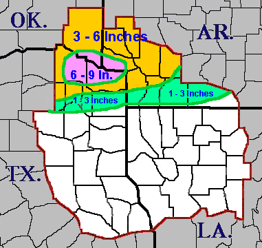
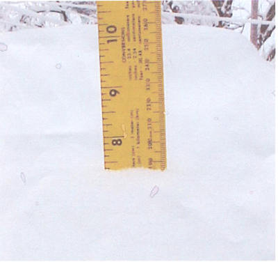
| An upper-level plume of Pacific moisture, a shallow layer of dry air near the surface, and a vigorous upper-level disturbance combined to produce a widespread area of wintry precipitation across the northern sections of the Four State Region. The precipitation began across East Texas late Monday night (February 4th) and overspread the rest of the region on Tuesday, February 5th. The temperature profile was just cold enough for the precipitation to fall mainly as snow north of a line from Pittsburg, TX, to along the Louisiana and Arkansas border. South of this line, the precipitation fell as a very cold rain with only a brief period of snow or sleet observed as far south as the Interstate 20 corridor. Snow amounts ranged from a relatively narrow band of 1 to 3 inches to a snow swath of 3 to 6 inches across Southeast Oklahoma, Southwest Arkansas, and extreme Northeast Texas. The heaviest snowfall fell over the Red River Valley of Northeast Texas, Southeast Oklahoma, and Southwest Arkansas, where 6 to 9 inches of snow fell. | |||||||||
| Graphics & Photos | |||||||||
|
|||||||||
| Back to Top | |||||||||
Current Hazards
Local
National
Outlooks
Submit Storm Report
Hazards Outlook
Radar Imagery
Nationwide
Shreveport, LA (SHV) Standard Radar
Fort Polk, LA (POE) Standard Radar
Forecasts
Local Forecast Info
Forecast Discussion
Graphical Forecasts
Tropical Weather
Fire Weather
Aviation Weather
Recreation Forecasts
Climate and Past Weather
Local Observed Reports
Climate Prediction
Local Data/Records
Storm Event Database
Past Events
Tropical Cyclone Reports
US Dept of Commerce
National Oceanic and Atmospheric Administration
National Weather Service
Shreveport, LA
5655 Hollywood Ave.
Shreveport, LA 71109
318-631-3669
Comments? Questions? Please Contact Us.