627
FNUS54 KSHV 190630
FWFSHV
Fire Weather Planning Forecast for Southwest Arkansas...
Northwest Louisiana...East Texas...and Extreme Southeast Oklahoma
National Weather Service Shreveport LA
130 AM CDT Sun Jul 19 2026
.DISCUSSION...
Quiet partly cloudy weather and hotter conditions are expected today
across area fire districts. Minimum relative humidity values will drop
into the 30 to 40 percent range while mixing heights climbs to between
4500 and 7000ft. Winds will become southwesterly to due westerly
through the day at maximum sustained speeds of 5 to 10 mph.
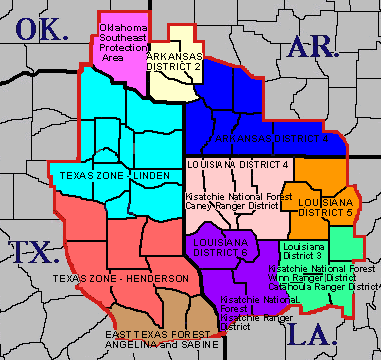
ARZ050-051-059-OKZ077-192115-
Sevier-Howard-Little River-McCurtain-
Including the cities of De Queen, Nashville, Mineral Springs,
Dierks, Ashdown, Idabel, and Broken Bow
130 AM CDT Sun Jul 19 2026
Today Tonight Mon
Cloud Cover Mclear Mclear Mclear
Precip Type None None None
Chance Precip (%) 0 0 0
Temp (24h trend) 94 (+2) 73 (0) 97
RH % (24h trend) 47 (-4) 86 (-4) 42
Wind 20ft/early(mph) LGT/VAR LGT/VAR LGT/VAR
Wind 20ft/late(mph) SW 4 LGT/VAR SW 4
Precip Amount 0.00 0.00 0.00
Precip Duration
Mixing Hgt(m-agl/msl) 1860 2290
Mixing Hgt(ft-agl/msl) 6090 7520
Transport Wnd (m/s) SW 3 SW 4
Transport Wnd (mph) SW 7 SW 8
Vent Rate (m/s-m) 5580 9160
Vent Rate (mph-ft) 42630 60160
Category Day 3 4
Dispersion Good Very Good
Max LVORI Early 6 4 5
Max LVORI Late 1 5 1
Mix Hgt 500 84 86
Stability Class B F B
Remarks...None.
.FORECAST FOR DAYS 3 THROUGH 7...
.TUESDAY...Mostly clear. Lows in the mid 70s. Highs in the upper
90s. Southwest winds around 5 mph.
.WEDNESDAY...Mostly clear. Lows in the upper 70s. Highs in the
upper 90s. North winds around 5 mph.
.THURSDAY...Mostly clear. Lows in the mid 70s. Highs in the mid
90s. East winds around 5 mph.
.FRIDAY...Mostly clear. Lows in the mid 70s. Highs in the mid
90s. East winds around 5 mph.
.SATURDAY...Mostly clear. Lows in the mid 70s. Highs in the mid
90s. South winds around 5 mph.
$$
ARZ060-061-070>073-192115-
Hempstead-Nevada-Miller-Lafayette-Columbia-Union-
Including the cities of Hope, Prescott, Texarkana, Stamps,
Lewisville, Bradley, Magnolia, and El Dorado
130 AM CDT Sun Jul 19 2026
Today Tonight Mon
Cloud Cover Clear Mclear Mclear
Precip Type None None None
Chance Precip (%) 0 0 0
Temp (24h trend) 96 (+1) 75 (+1) 99
RH % (24h trend) 39 (-6) 84 (-6) 38
Wind 20ft/early(mph) LGT/VAR LGT/VAR LGT/VAR
Wind 20ft/late(mph) LGT/VAR LGT/VAR LGT/VAR
Precip Amount 0.00 0.00 0.00
Precip Duration
Mixing Hgt(m-agl/msl) 2060 2580
Mixing Hgt(ft-agl/msl) 6750 8480
Transport Wnd (m/s) W 4 W 4
Transport Wnd (mph) W 8 W 8
Vent Rate (m/s-m) 8240 10320
Vent Rate (mph-ft) 54000 67840
Category Day 4 4
Dispersion Very Good Very Good
Max LVORI Early 6 3 4
Max LVORI Late 1 4 1
Mix Hgt 500 88 90
Stability Class B F B
Remarks...None.
.FORECAST FOR DAYS 3 THROUGH 7...
.TUESDAY...Mostly clear. Lows in the mid 70s. Highs in the upper
90s. Light winds.
.WEDNESDAY...Mostly clear. Lows in the upper 70s. Highs around
100. Light winds.
.THURSDAY...Mostly clear. Lows in the mid 70s. Highs in the mid
90s. Northeast winds around 5 mph.
.FRIDAY...Mostly clear. Lows in the mid 70s. Highs in the mid
90s. Light winds.
.SATURDAY...Partly cloudy. Lows in the mid 70s. Highs in the mid
90s. Light winds.
$$
TXZ096-097-108>112-124>126-137-138-192115-
Red River-Bowie-Franklin-Titus-Camp-Morris-Cass-Wood-Upshur-
Marion-Gregg-Harrison-
Including the cities of Clarksville, Bogata, Texarkana,
Mount Vernon, Mount Pleasant, Pittsburg, Daingerfield, Lone Star,
Naples, Omaha, Atlanta, Linden, Hughes Springs, Queen City,
Mineola, Winnsboro, Quitman, Hawkins, Gilmer, Big Sandy,
Jefferson, Longview, and Marshall
130 AM CDT Sun Jul 19 2026
Today Tonight Mon
Cloud Cover Mclear Clear Clear
Precip Type None None None
Chance Precip (%) 0 0 0
Temp (24h trend) 95 (+1) 74 (-1) 99
RH % (24h trend) 40 (-6) 83 (-7) 37
Wind 20ft/early(mph) SW 3 LGT/VAR W 3
Wind 20ft/late(mph) SW 4 LGT/VAR SW 3
Precip Amount 0.00 0.00 0.00
Precip Duration
Mixing Hgt(m-agl/msl) 2050 2350
Mixing Hgt(ft-agl/msl) 6720 7690
Transport Wnd (m/s) SW 4 W 4
Transport Wnd (mph) SW 8 W 8
Vent Rate (m/s-m) 8200 9400
Vent Rate (mph-ft) 53760 61520
Category Day 4 4
Dispersion Very Good Very Good
Max LVORI Early 5 3 4
Max LVORI Late 1 4 1
Mix Hgt 500 86 88
Stability Class B F B
Remarks...None.
.FORECAST FOR DAYS 3 THROUGH 7...
.TUESDAY...Clear. Lows in the upper 70s. Highs in the upper 90s.
Southwest winds around 5 mph.
.WEDNESDAY...Clear. Lows in the upper 70s. Highs around 100. West
winds around 5 mph.
.THURSDAY...Mostly clear. Lows in the upper 70s. Highs in the
upper 90s. East winds around 5 mph.
.FRIDAY...Mostly clear. Lows in the upper 70s. Highs in the upper
90s. East winds around 5 mph.
.SATURDAY...Mostly clear. Lows in the upper 70s. Highs in the
upper 90s. South winds around 5 mph.
$$
TXZ136-149>153-192115-
Smith-Cherokee-Rusk-Panola-Nacogdoches-Shelby-
Including the cities of Tyler, Jacksonville, Rusk, Henderson,
Carthage, Nacogdoches, and Center
130 AM CDT Sun Jul 19 2026
Today Tonight Mon
Cloud Cover Mclear Clear Mclear
Precip Type None None None
Chance Precip (%) 0 0 0
Temp (24h trend) 95 (+1) 75 (0) 96
RH % (24h trend) 42 (-6) 86 (-9) 36
Wind 20ft/early(mph) SW 3 LGT/VAR W 3
Wind 20ft/late(mph) SW 4 LGT/VAR SW 4
Precip Amount 0.00 0.00 0.00
Precip Duration
Mixing Hgt(m-agl/msl) 1700 2180
Mixing Hgt(ft-agl/msl) 5590 7140
Transport Wnd (m/s) SW 3 W 3
Transport Wnd (mph) SW 7 W 7
Vent Rate (m/s-m) 5100 6540
Vent Rate (mph-ft) 39130 49980
Category Day 3 3
Dispersion Good Good
Max LVORI Early 6 3 4
Max LVORI Late 1 4 1
Mix Hgt 500 84 86
Stability Class B F B
Remarks...None.
.FORECAST FOR DAYS 3 THROUGH 7...
.TUESDAY...Clear. Lows in the mid 70s. Highs in the upper 90s.
Southwest winds around 5 mph.
.WEDNESDAY...Mostly clear. Lows in the upper 70s. Highs around
101. Southwest winds around 5 mph.
.THURSDAY...Mostly clear. Lows in the upper 70s. Highs in the
upper 90s. Northeast winds around 5 mph.
.FRIDAY...Mostly clear. Lows in the upper 70s. Highs in the upper
90s. Southeast winds around 5 mph.
.SATURDAY...Partly cloudy. Lows in the upper 70s. Highs in the
upper 90s. South winds around 5 mph.
$$
TXZ165>167-192115-
Angelina-San Augustine-Sabine-
Including the cities of Lufkin, San Augustine, Hemphill,
and Pineland
130 AM CDT Sun Jul 19 2026
Today Tonight Mon
Cloud Cover Mclear Clear Mclear
Precip Type None None None
Chance Precip (%) 0 0 0
Temp (24h trend) 95 (+1) 75 (0) 97
RH % (24h trend) 42 (-9) 86 (-8) 35
Wind 20ft/early(mph) LGT/VAR LGT/VAR LGT/VAR
Wind 20ft/late(mph) LGT/VAR LGT/VAR W 3
Precip Amount 0.00 0.00 0.00
Precip Duration
Mixing Hgt(m-agl/msl) 1370 1740
Mixing Hgt(ft-agl/msl) 4480 5710
Transport Wnd (m/s) SW 3 W 3
Transport Wnd (mph) SW 6 W 7
Vent Rate (m/s-m) 4110 5220
Vent Rate (mph-ft) 26880 39970
Category Day 3 3
Dispersion Good Good
Max LVORI Early 6 3 5
Max LVORI Late 2 5 2
Mix Hgt 500 84 86
Stability Class B F B
Remarks...None.
.FORECAST FOR DAYS 3 THROUGH 7...
.TUESDAY...Clear. Lows in the upper 70s. Highs in the upper 90s.
West winds around 5 mph.
.WEDNESDAY...Mostly clear. Lows in the upper 70s. Highs around
100. West winds around 5 mph.
.THURSDAY...Mostly clear. Lows in the upper 70s. Highs in the
upper 90s. Light winds.
.FRIDAY...Mostly clear. Lows in the upper 70s. Highs in the upper
90s. Light winds.
.SATURDAY...Partly cloudy. Lows in the upper 70s. Highs in the
mid 90s. Light winds.
$$
LAZ001>004-012-192115-
Caddo-Bossier-Webster-Claiborne-Bienville-
Including the cities of Shreveport, Bossier City, Minden,
Springhill, Homer, Haynesville, Arcadia, Ringgold, and Gibsland
130 AM CDT Sun Jul 19 2026
Today Tonight Mon
Cloud Cover Clear Clear Mclear
Precip Type None None None
Chance Precip (%) 0 0 0
Temp (24h trend) 96 (+1) 75 (0) 97
RH % (24h trend) 39 (-6) 81 (-11) 38
Wind 20ft/early(mph) LGT/VAR LGT/VAR LGT/VAR
Wind 20ft/late(mph) SW 3 LGT/VAR W 3
Precip Amount 0.00 0.00 0.00
Precip Duration
Mixing Hgt(m-agl/msl) 1910 2550
Mixing Hgt(ft-agl/msl) 6270 8360
Transport Wnd (m/s) W 3 W 4
Transport Wnd (mph) W 7 W 8
Vent Rate (m/s-m) 5730 10200
Vent Rate (mph-ft) 43890 66880
Category Day 3 4
Dispersion Good Very Good
Max LVORI Early 6 3 4
Max LVORI Late 1 4 1
Mix Hgt 500 88 89
Stability Class B F B
Remarks...None.
.FORECAST FOR DAYS 3 THROUGH 7...
.TUESDAY...Mostly clear. Lows in the upper 70s. Highs in the
upper 90s. West winds around 5 mph.
.WEDNESDAY...Mostly clear. Lows in the upper 70s. Highs around
101. West winds around 5 mph.
.THURSDAY...Mostly clear. Lows in the upper 70s. Highs in the
upper 90s. North winds around 5 mph.
.FRIDAY...Mostly clear. Lows in the mid 70s. Highs in the mid
90s. Light winds.
.SATURDAY...Partly cloudy. Lows in the mid 70s. Highs in the mid
90s. Light winds.
$$
LAZ005-006-013-014-192115-
Lincoln-Union-Jackson-Ouachita-
Including the cities of Ruston, Farmerville, Bernice, Jonesboro,
and Monroe
130 AM CDT Sun Jul 19 2026
Today Tonight Mon
Cloud Cover Clear Clear Mclear
Precip Type None None None
Chance Precip (%) 0 0 0
Temp (24h trend) 95 (0) 76 (+1) 97
RH % (24h trend) 41 (-5) 81 (-10) 41
Wind 20ft/early(mph) LGT/VAR LGT/VAR LGT/VAR
Wind 20ft/late(mph) LGT/VAR LGT/VAR LGT/VAR
Precip Amount 0.00 0.00 0.00
Precip Duration
Mixing Hgt(m-agl/msl) 2030 2600
Mixing Hgt(ft-agl/msl) 6650 8520
Transport Wnd (m/s) W 3 NW 3
Transport Wnd (mph) W 6 NW 7
Vent Rate (m/s-m) 6090 7800
Vent Rate (mph-ft) 39900 59640
Category Day 3 3
Dispersion Good Good
Max LVORI Early 6 3 4
Max LVORI Late 1 4 1
Mix Hgt 500 89 92
Stability Class B F B
Remarks...None.
.FORECAST FOR DAYS 3 THROUGH 7...
.TUESDAY...Mostly clear. Lows in the upper 70s. Highs in the
upper 90s. West winds around 5 mph.
.WEDNESDAY...Mostly clear. Lows in the upper 70s. Highs around
100. West winds around 5 mph.
.THURSDAY...Mostly clear. Lows in the upper 70s. Highs in the mid
90s. Northeast winds around 5 mph.
.FRIDAY...Mostly clear. Lows in the mid 70s. Highs in the mid
90s. Light winds.
.SATURDAY...Partly cloudy. Lows in the mid 70s. Highs in the mid
90s. Light winds.
$$
LAZ010-011-017-018-192115-
De Soto-Red River-Sabine-Natchitoches-
Including the cities of Mansfield, Stonewall, Logansport,
Coushatta, Martin, Many, Zwolle, Pleasant Hill, and Natchitoches
130 AM CDT Sun Jul 19 2026
Today Tonight Mon
Cloud Cover Mclear Clear Clear
Precip Type None None None
Chance Precip (%) 0 0 0
Temp (24h trend) 95 (+1) 75 (0) 96
RH % (24h trend) 41 (-7) 88 (-9) 37
Wind 20ft/early(mph) LGT/VAR LGT/VAR LGT/VAR
Wind 20ft/late(mph) LGT/VAR LGT/VAR LGT/VAR
Precip Amount 0.00 0.00 0.00
Precip Duration
Mixing Hgt(m-agl/msl) 1660 2090
Mixing Hgt(ft-agl/msl) 5460 6860
Transport Wnd (m/s) W 3 W 3
Transport Wnd (mph) W 6 W 7
Vent Rate (m/s-m) 4980 6270
Vent Rate (mph-ft) 32760 48020
Category Day 3 3
Dispersion Good Good
Max LVORI Early 7 3 5
Max LVORI Late 2 5 1
Mix Hgt 500 86 89
Stability Class B F B
Remarks...None.
.FORECAST FOR DAYS 3 THROUGH 7...
.TUESDAY...Mostly clear. Lows in the upper 70s. Highs in the
upper 90s. Light winds.
.WEDNESDAY...Mostly clear. Lows in the upper 70s. Highs around
100. Light winds.
.THURSDAY...Mostly clear. Lows in the upper 70s. Highs in the
upper 90s. Light winds.
.FRIDAY...Mostly clear. Lows in the mid 70s. Highs in the mid
90s. Light winds.
.SATURDAY...Partly cloudy. Lows in the mid 70s. Highs in the mid
90s. Light winds.
$$
LAZ019>022-192115-
Winn-Grant-Caldwell-La Salle-
Including the cities of Winnfield, Colfax, Montgomery, Dry Prong,
Clarks, Grayson, Columbia, Jena, Midway, and Olla
130 AM CDT Sun Jul 19 2026
Today Tonight Mon
Cloud Cover Clear Mclear Mclear
Precip Type None None None
Chance Precip (%) 0 0 0
Temp (24h trend) 96 (0) 75 (0) 98
RH % (24h trend) 41 (-6) 86 (-10) 40
Wind 20ft/early(mph) W 3 LGT/VAR W 3
Wind 20ft/late(mph) LGT/VAR LGT/VAR W 3
Precip Amount 0.00 0.00 0.00
Precip Duration
Mixing Hgt(m-agl/msl) 1830 2430
Mixing Hgt(ft-agl/msl) 6010 7960
Transport Wnd (m/s) W 3 NW 4
Transport Wnd (mph) W 6 NW 8
Vent Rate (m/s-m) 5490 9720
Vent Rate (mph-ft) 36060 63680
Category Day 3 4
Dispersion Good Very Good
Max LVORI Early 6 4 5
Max LVORI Late 2 5 1
Mix Hgt 500 87 91
Stability Class B F B
Remarks...None.
.FORECAST FOR DAYS 3 THROUGH 7...
.TUESDAY...Mostly clear. Lows in the upper 70s. Highs in the
upper 90s. West winds around 5 mph.
.WEDNESDAY...Mostly clear. Lows in the upper 70s. Highs around
101. West winds around 5 mph.
.THURSDAY...Mostly clear. Lows in the upper 70s. Highs in the
upper 90s. North winds around 5 mph.
.FRIDAY...Partly cloudy. Lows in the mid 70s. Highs in the upper
90s. North winds around 5 mph.
.SATURDAY...Partly cloudy. Lows in the mid 70s. Highs in the mid
90s. Light winds.
$$
|