Flash flooding threatens areas from the Tennessee Valley to the Carolinas as storms repeat along a stalled front. Monsoonal storms may trigger flooding in the Southwest. Dangerous heat expands across the Desert Southwest, Plains, mid-Mississippi Valley and Southern Tier. Critical fire weather for interior Pacific Northwest. Cooler, drier air brings brief relief to the Great Lakes and Northeast. Read More >
Shreveport, LA
Weather Forecast Office
| Overview | |||||||||||||||||||||||
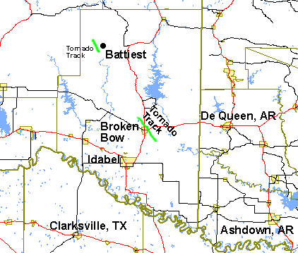
| Severe thunderstorms brought tornadoes to McCurtain County in Southeast Oklahoma on May 1st, 2003. One tornado, rated F0, affected areas near Battiest. Another tornado, rated F2, impacted Broken Bow. Below is a summary of the tornadoes that were confirmed by National Weather Service officials. | |||||||||||||||||||||||
|
TOTAL TORNADO COUNT = 2
|
|||||||||||||||||||||||
|
Tornado Table
Graphics
|
|||||||||||||||||||||||
| Back to Top | |||||||||||||||||||||||
Current Hazards
Local
National
Outlooks
Submit Storm Report
Hazards Outlook
Radar Imagery
Nationwide
Shreveport, LA (SHV) Standard Radar
Fort Polk, LA (POE) Standard Radar
Forecasts
Local Forecast Info
Forecast Discussion
Graphical Forecasts
Tropical Weather
Fire Weather
Aviation Weather
Recreation Forecasts
Climate and Past Weather
Local Observed Reports
Climate Prediction
Local Data/Records
Storm Event Database
Past Events
Tropical Cyclone Reports
US Dept of Commerce
National Oceanic and Atmospheric Administration
National Weather Service
Shreveport, LA
5655 Hollywood Ave.
Shreveport, LA 71109
318-631-3669
Comments? Questions? Please Contact Us.