Tropical Storm Bertha could bring tropical storm conditions to portions of the Florida Panhandle and Alabama coast through Wednesday, where a Tropical Storm Watch and Storm Surge Watch is in effect. Numerous severe thunderstorms with heavy rainfall are expected from the Ohio Valley into the Mid-Atlantic and Northeast Tuesday. Read More >
Shreveport, LA
Weather Forecast Office
| Overview | |||||||||
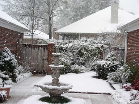
| An intrusion of cold air filtered into the Four State Region a few days before Valentine's Day. Temperatures were 10 to 15 degrees below average from Thursday, February 12th through Valentine's Day on Saturday, February 14th. Late Friday night and Saturday, a strong upper-level disturbance tracked across the region producing a large area of snow, mainly along and to the north of Interstate 20 even though surface temperatures were generally just above freezing. Most, if not all, of the snow melted the day after the snowstorm as temperatures climbed into the 50s areawide under sunny skies. |
|||||||||
| Graphics & Photos | |||||||||
|
|||||||||
| Back to Top | |||||||||
Current Hazards
Local
National
Outlooks
Submit Storm Report
Hazards Outlook
Radar Imagery
Nationwide
Shreveport, LA (SHV) Standard Radar
Fort Polk, LA (POE) Standard Radar
Forecasts
Local Forecast Info
Forecast Discussion
Graphical Forecasts
Tropical Weather
Fire Weather
Aviation Weather
Recreation Forecasts
Climate and Past Weather
Local Observed Reports
Climate Prediction
Local Data/Records
Storm Event Database
Past Events
Tropical Cyclone Reports
US Dept of Commerce
National Oceanic and Atmospheric Administration
National Weather Service
Shreveport, LA
5655 Hollywood Ave.
Shreveport, LA 71109
318-631-3669
Comments? Questions? Please Contact Us.