| Overview |
|
Drought conditions, which began during the middle springtime months of 2005, continued to worsen through the fall/winter months across much of the Four State Region, with much below normal rainfall occurring since October, 2005. However, it should be noted that Hurricane Rita, which made landfall near Cameron, LA, during the early morning hours of September 24th, produced widespread 2 to 4 inch rainfall amounts, with a narrow swath of 5 to 12 inch totals along the path of the center of circulation from Deep East Texas into extreme Northwest Louisiana (see adjacent image), tracking from just east of Lufkin, TX, across Shreveport, LA, while weakening. Because of the excessive rainfall that fell from this hurricane, September rainfall totals were near/above normal in most locations, although very little rainfall fell before/after this storm impacted the area.
|
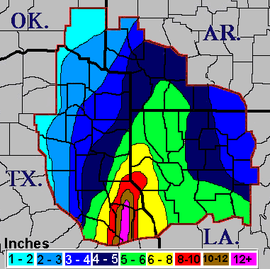 |
| Map showing rainfall received from Hurricane Rita in September 2005. |
|
| |
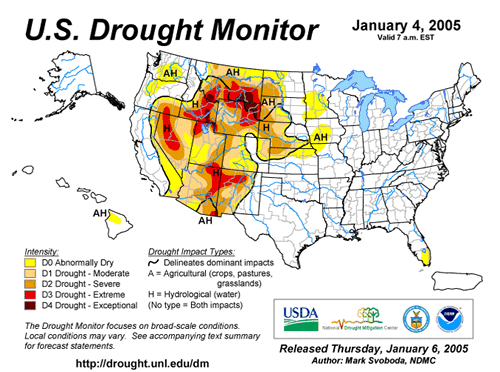
| The Fall and Winter months of 2005-06 continued the trend of above normal average temperatures, especially October, where many locations recorded not only very little rainfall, but fell into the top 15 warmest Octobers on record. The lack of rainfall and warm temperatures aided in the worsening of the drought, with the U.S. Drought Monitor upgrading Northeast Texas north of Interstate 20, Southeast Oklahoma, and adjacent sections of Southwest Arkansas into Exceptional Drought status, the most crippling drought classification ever. Extreme Drought conditions prevailed farther south across much of the rest of East Texas, Northwest Louisiana, and the remainder of Southwest Arkansas, while Severe to Moderate Drought conditions continued elsewhere across Deep East Texas and North Central Louisiana. These very dry conditions contributed to the growth of many wildfires over the region, fueled by additional brush/dead plants that were killed by freezing temperatures which occurred in November and December. Strong winds and very low afternoon relative humidities aided in the development/spread of these wildfires, with county/parishwide burn bans in place for much of the Four State Region from late December through the first three weeks of January. These fires charred tens of thousands of acres areawide. |
| |
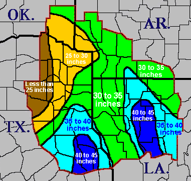 |
| Here is a graphical of the cumulative 2005 annual rainfall across the area. Locations across Southeast Oklahoma, Northeast Texas, and adjacent areas of Southwest Arkansas were much drier than the rest of the region. The spike of rainfall across Deep East Texas was due to Hurricane Rita. The other spike across North Central Louisiana had more than one cause, but the main reason was that moisture from the Gulf of Maxico had more time to return northward in this area before drier air from the west or northwest overspread the region. |
|
| |
|
| The relentless drought had a dramatic impact on the region economically and recreationally. Hay production decreased significantly over East Texas, in which only a quarter to a third of the norm was produced, as many farmers were only able to make one or two cuts all summer. As a result, the U.S. Department of Agriculture designated several East Texas counties as natural disaster areas, allowing farmers to apply for low interest federal loans through the Farm Bureau Service. In fact, Texas drought losses for 2005 topped $1.5 Billion! Many area lakes, rivers, and underground aquifers remain at or near record low pool stages, with the city of Shreveport had plans to draw water from Twelve Mile Bayou in an effort to raise the level on Cross Lake, the city’s water supply, as the lake was some 3+ feet below normal pool stage. The drought dried up wetlands and destroyed waterfowl habitats in Arkansas, forcing a 50% decrease in the number of waterfowl statewide. |
| |
| 2005 Ended As One of the Top 10 Driest Years On Record |
| The following table indicates the cumulative 2005 rainfall total, their departures, and other statistics for selected cities in the Four State Region: |
| LOCATION |
2005 RAINFALL
(INCHES) |
2005 DEPARTURE
FROM NORMAL
(INCHES) |
PERCENTAGE OF
NORMAL RAINFALL
(INCHES) |
DRIEST YEAR
RANKING |
PERIOD
OF RECORD |
| Shreveport, LA |
32.98 |
-18.32 |
64% |
14th |
Since 1872 |
| Monroe, LA |
31.23 |
-22.11 |
59% |
3rd |
Since 1930 |
| Texarkana, AR |
27.63 |
-19.75 |
58% |
6th |
Since 1892 |
| El Dorado, AR |
28.30 |
-25.81 |
52% |
4th |
Since 1892 |
| De Queen, AR |
28.04 |
-27.07 |
51% |
7th |
Since 1936 |
| Tyler, TX |
24.90 |
-20.37 |
55% |
2nd |
Since 1898 |
| Longview, TX |
29.92 |
-19.01 |
61% |
9th |
Since 1902 |
| Lufkin, TX |
31.68 |
-14.94 |
68% |
12th |
Since 1948 |
|
| |
 |
| |


