A significant heat wave continues for the Rockies, Northern Plains, and Great Lakes into the Mid-Atlantic, peaking in intensity through midweek and lingering across parts of the Northern Plains and Midwest until this weekend. Excessive rainfall my bring life-threatening and locally catastrophic flash and urban flooding across portions of southwestern Texas through early Friday. Read More >
| Overview | |||||||||||||||||||||||||||||||||||||||||||||||||||||||||||||||||||||||||||||||||||||||||||||||
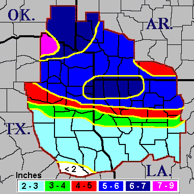
| A prolonged period of rain fell across the Four State Region during a four-day period from late Friday, March 17, through Monday, March 20, 2006. The heaviest rain fell north of Interstate 20 during this event with rainfall amounts generally between 4 and 6 inches with some totals just over 8 inches across Red River County in Northeast Texas. | |||||||||||||||||||||||||||||||||||||||||||||||||||||||||||||||||||||||||||||||||||||||||||||||
| Graphics | |||||||||||||||||||||||||||||||||||||||||||||||||||||||||||||||||||||||||||||||||||||||||||||||
|
|||||||||||||||||||||||||||||||||||||||||||||||||||||||||||||||||||||||||||||||||||||||||||||||
| Rainfall Totals | |||||||||||||||||||||||||||||||||||||||||||||||||||||||||||||||||||||||||||||||||||||||||||||||
| Southerly winds just above the surface ushered copious amounts of moisture from the Gulf of America over a nearly stationary frontal boundary across Central Texas. This moisture, combined with a few upper level disturbance ahead of the main trough across the Western United States, resulted in nearly continuous rainfall with a few thunderstorms from Friday night through Sunday mainly along and north of Interstate 20. The heaviest rainfall was along the Interstate 30 corridor. The upper trough pushed east into the Southern Plains Sunday night and Monday. This allowed the frontal boundary to push a bit farther north as a warm front into East Texas and Central Louisiana. This brought another round of heavy rainfall and thunderstorms across the region. Finally, the rain came to an end Monday evening, March 20th, 2006. |
|||||||||||||||||||||||||||||||||||||||||||||||||||||||||||||||||||||||||||||||||||||||||||||||
|
|
||||||||||||||||||||||||||||||||||||||||||||||||||||||||||||||||||||||||||||||||||||||||||||||
| Back to top | |||||||||||||||||||||||||||||||||||||||||||||||||||||||||||||||||||||||||||||||||||||||||||||||