Wildfire Smoke and Severe Thunderstorms in the East; Monsoon Thunderstorms in the Southwest
Wildfire smoke continues to impact air quality from the Great Lakes region into New England and the Mid-Atlantic today with widespread Air Quality Alerts in effect. Severe thunderstorms are expected across portions of the Ohio Valley and Lower Great Lakes into the Mid-Atlantic and Northeast, this afternoon into the evening. Monsoonal thunderstorms may bring areas of flooding to the Southwest.
Read More >
The period between the afternoon of Saturday, May 2nd 2009 through Sunday morning of May 3rd marked another major weather event for the four-state region. Some locations across the region experienced severe thunderstorm activity and tornadoes, while other locations received up to 6 inches of rain. And a few locations saw it all.
The National Weather Service in Shreveport has confirmed a total of seven tornadoes occurred, as well as an intense derecho.
TOTAL TORNADO COUNT = 7
EF0 = 4
EF1 = 2
EF2 = 1
Tornado Table
Straight-Line Winds
Heavy Rainfall
TOR. #
START POINT
END
POINT
RATING
PEAK WIND
START TIME
END TIME
LENGTH/
WIDTH
FATALITIES/
INJURIES
REMARKS
MAY 2, 2009
#1
5 miles SSW of DeKalb, Bowie County, TX
4 miles SSW of DeKalb, Bowie County, TX
EF0
60-75 mph
4:44pm CDT
4:46pm CDT
1 mile/
75 yards
None
Several trees were uprooted and snapped along CR 4250 and near CR 4245 next to a house. No structural damage was noted.
#2
3 miles NNW of Douglassville, Cass County, TX
2.5 miles NNE of Douglassville, Cass County, TX
EF1
85-90 mph
5:51pm CDT
5:54pm CDT
2 miles/
125 yards
None
Several trees were uprooted or snapped along State Highway 8 north of Douglassville on both sides of the highway. Some minor shingle damage was noted to houses along the highway. Along CR 2123, numerous hardwood trees were snapped and uprooted next to a church. No structural damage was noted
#3
10 miles NW of Fouke , Miller County, AR
8 miles NW of Fouke, Miller County, AR
EF1
90-95 mph
6:13pm CDT
6:18pm CDT
3.75 miles/
150 yards
3 injuries
Numerous trees and power lines were snapped along Blackman Ferry Road and along CR 10. A porch and contents of a porch of a house near that intersection were blown off the back of the house and strewn downstream a half mile. Straight-line winds were also noted in the area along Blackman Ferry Road with numerous trees snapped and uprooted. Damage also extended west to State Line Road. Injuries occurred along Blackman Ferry Road where a power pole fell on a car injuring the driver and two passengers.
#4
4 miles SSE of Leesburg, Camp County, TX
2 miles SE of Leesburg, Camp County, TX
EF0
65-70 mph
8:56pm CDT
8:59pm CDT
2 miles/
75 yards
None
Several trees were uprooted or snapped along CR 3510 and near CR 3322. No structural damage was noted.
MAY 3, 2009
#5
3 miles SE of Castor, Bienville Parish, LA
3.5 miles ESE of Castor, Bienville Parish, LA
EF0
65-70 mph
7:38am CDT
7:41am CDT
1.75 miles/
50 yards
None
Several trees were uprooted or snapped along Pumpkin Center Road northeastward to Ridge Road east of Castor. Several power lines were also downed in the area.
#6
10 miles W of Quitman, Bienville Parish, LA
9 miles W of Quitman, Bienville Parish, LA
EF0
65-70 mph
8:03am CDT
8:05am CDT
1.1 miles/
50 yards
None
Several trees were uprooted or snapped along Hwy 508 east of Bienville. Several more trees were uprooted along Hwy 155.
#7
Dodson, Winn Parish, LA
1.5 miles NNE of Dodson, Winn Parish, LA
EF2
110-120 mph
8:40am CDT
8:43am CDT
1.5 miles/
300 yards
2 injuries
Numerous homes were damaged in the town of Dodson with several completely destroyed. One mobile home was picked up and moved 30 feet west of its original location where it was destroyed with parts of the frame wrapped around a neighboring home. The two injuries occurred in the destroyed home. Approximately 18 homes in the center of Dodson sustained damage. A mobile home in the center of Dodson was rolled off its foundation and destroyed. The tornado touched down on the south side of town along U.S. Hwy 167 and moved northward 1.5 miles before lifting along State Route 1235.
EVENT
LOCATION
PEAK WIND
START TIME
END TIME
FATALITIES/
INJURIES
REMARKS
Derecho Event
Grant, Natchitoches, and Winn Parishes in Louisiana
100-110 mph
8:10am CDT
8:30am CDT
1 injury
On the morning of May 3, 2009, a strong derecho swept across portions of North Central Louisiana.
In Natchitoches Parish: Numerous homes and businesses were several damaged in the town of Natchez including city hall where the roof was completely removed. Natchitoches Parish officials reported 53 residences, 11 vehicles, 2 businesses, and 2 boats were damaged or destroyed. Numerous trees were snapped and uprooted from Natchez southward along State Route 494 and across the Cane River.
In Grant Parish: Numerous homes were damaged either by falling trees or sustained roof damage from wind along U.S. Hwy 71. This includes a barn that was completely destroyed. The damage pattern was consistent with a downburst where a concentrated area of damage spread outward and east toward Nantachie Lake where 6 steel transmission lines were bent. The width of the damage path along Hwy 71 was approximately 1 mile wide where trees were snapped and/or uprooted and the great concentration of damage occurred.
In Winn Parish: Numerous power outages were reported parish-wide with 6 residences damaged in the parish from fallen trees.
Bow echo-associated straight-line winds
Near Rusk, Cherokee County, TX
Damage in this area was caused by strong straight-line winds associated with a bow echo. The damage occurred along Hwy 241 and FM 2407 about 4 miles south of Rusk, and along Hwy 84 about 1 mile east of Rusk. Damage consisted of several trees snapped or uprooted and minor damage to the roofs of a few houses. There were also several power lines blown down.
Bow echo-associated straight-line winds
Near Logansport, DeSoto Parish, LA
80 mph
Strong straight-line winds associated with a bow echo caused damage along Hwy 191 and Murphrey Road about 4 miles southeast of Logansport. Damage consisted of many trees being snapped or uprooted, and minor damage to the roofs of a few houses. There were also several power lines blown down.
An eyewitness estimated that winds were about 80 mph for 20 minutes.
Numerous homes and cars were flooded across the ArkLaTex. Several counties in East Texas (Bowie, Camp, Cass, Wood, Gilmer, Upshur, Titus, Franklin, and Red River) reported numerous road closures. In Texarkana, several cars were flooded out in intersections with several underpasses flooded. Early on May 3, 2009, numerous road closures were reported in Shreveport. Several CoCoRAHs sites have reported up to 6 inches of rain within a few hours. Some homes have also reported water on the south side of the city.
Selected Rainfall Reports from May 2-3, 2009
ARKANSAS
LOCATION
AMOUNT
Ashdown
3.37 inches
Athens
3.07 inches
De Queen Dam
5.35 inches
Calion Lock
2.52 inches
Lewisville
3.63 inches
Nashville
2.47 inches
LOUISIANA
5 miles E of Benton
1.81 inches
Farmerville
5.52 inches
1 mile N of Homer
2.85 inches
Monroe (Univ. of LA-Monroe)
2.12 inches
Mooringsport
2.00 inches
Plain Dealing
4.29 inches
Rodessa
5.07 inches
Shreveport-Southern Hills
5.07 inches
Taylortown
4.75 inches
Wallace Lake
5.57 inches
Selected Rainfall Reports from May 2-3, 2009
TEXAS
LOCATION
AMOUNT
Atlanta
6.05 inches
Clarksville
4.02 inches
Gilmer
4.81 inches
Hallsville
2.95 inches
Holly Lake Ranch
5.65 inches
Henderson
1.77 inches
Jefferson
3.35 inches
Linden
5.35 inches
Mineola
4.27 inches
Mount Pleasant
4.67 inches
Mount Vernon
3.94 inches
OKLAHOMA
Battiest
3.50 inches
Idabel
2.47 inches
Unger
3.65 inches
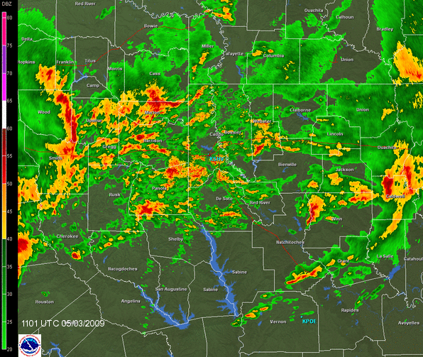
Radar loop of a large thunderstorm complex, called a derecho, which pushed across East Central Texas and Central Louisiana. Winds along this line of thunderstorms were in excess of 70 mph, and damaged or destroyed what could be thousands of trees and power lines across the region. Several structures received damaged from these strong winds, and some injuries have been reported.
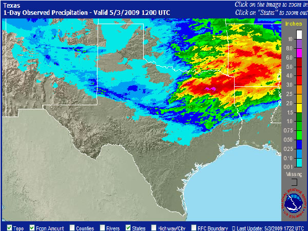
Map of radar-estimated precipitation. Notice the band of reds and pinks across Northeast Texas through Southwest Arkansas. 6 to 8 inches of rain may have fallen in some portions of Northeast Texas.