| TOR. # |
START POINT |
END
POINT |
RATING |
PEAK WIND |
START TIME |
END TIME |
LENGTH/
WIDTH |
FATALITIES/
INJURIES |
REMARKS |
| DECEMBER 23, 2009 |
| #1 |
6 miles ENE of Jacksonville, Cherokee County, TX |
8 miles ENE of Jacksonville, Cherokee County, TX |
EF0 |
60-70 mph |
2:35pm CST |
2:41pm CST |
2 miles/
50 yards |
None |
This tornado began one mile northeast of Jacksonville Club Lake on the east end of CR 4218. One downed tree was observed with a few trees topped with large branches broken. The tornado moved east-northeast where more tree damage was observed on CR 4222 and south of CR 4223. |
| #2 |
9 miles ENE of New Summerfield, Cherokee County, TX |
12 miles ENE of New Summerfield, Cherokee County, TX |
EF0 |
60-70 mph |
3:04pm CST |
3:10pm CST |
3 miles/
50 yards |
None |
This tornado touched down one mile southeast of Barrons Lake on CR 4619 just north of FM 13. A couple of trees were downed and a few with large branches broken. The tornado tracked northeast where most tree damage was observed on CR 4621 just west of the Cherokee/Rusk County line. |
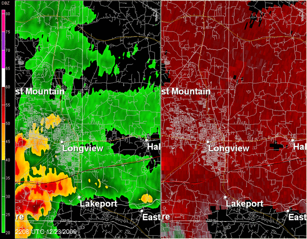
| #3 |
East side of Longview, Harrison County, TX |
8 miles NE of Longview, Harrison County, TX |
EF2 |
110-120 mph |
4:39pm CST |
4:56pm CST |
7 miles/
200 yards |
None |
This tornado began on the east side of Longview, just west of the intersections of E Cotton Street and Industrial Drive. It track north-northeast causing damage to several industrial buildings along Industrial Drive. It crossed Industrial Drive just south of Hwy 80 causing significant damage to the FedEx building and other surrounding industrial businesses.
The tornado crossed Hwy 80 causing significant tree and roof damage to several homes in a residential neighborhood. The track continued north-northeast as the tornado crossed Loop 281 just south of Page Road. A home on Page Road sustained major roof damage. The tornado continued to cause tree and roof damage in a residential area before crossing Peter Bonner Road near Sand Lane. More tree and roof damage was observed as the storm tracked into a rural area, ending south of FM 449 on Keasler Road. |
| #4 |
3 miles SE of Avinger, Cass County, TX |
3 miles SE of Avinger, Cass County, TX |
EF1 |
86 mph |
5:51pm CST |
5:52pm CST |
50 yards/
50 yards |
None |
This tornado touched down in a wooded area along CR 1617 in southern Cass County, approximately 3 miles southeast of Avinger. Low-end EF1 damage was noted as the small tornado traveled north-northeast snapping and uprooting several pine and oak trees. In addition, numerous small branches were also blown down before the tornado lifted. |
| #5 |
8 miles NNE of Recklaw, Rusk County, TX |
8 miles NNE of Recklaw, Rusk County, TX |
EF0 |
70-80 mph |
7:16pm CST |
7:17pm CST |
0.1 mile/
150 yards |
None |
A tornado briefly touched down along CR 4188 and uprooted or snapped several trees.. |
| #6 |
South side of Lufkin, Angelina County, TX |
3 miles NE of Lufkin, Angelina County, TX |
EF3 |
127-137 mph |
9:56pm CST |
10:07pm CST |
4 miles/
300 yards |
None |
This tornado began on the south side of Lufkin on Loop 287 near the Olive Garden restaurant, just west of the intersection of Loop 287 and South Chestnut Street. The tornado tracked north-northeast causing roof and tree damage to several homes behind the Morgan Insurance Company on Loop 287. It crossed South Chestnut Street and caused major damage to the Gibson Funeral Home. The tornado tracked northward through a residential neighborhood causing more tree and roof damage before destroying Max's Welding Shop on Denman Road.
The tornado crossed Denman Road moving through another residential area and caused moderate to major tree and roof damage. The VFW building was destroyed before the tornado crossed Lufkin Avenue. More residential damage was observed between Lufkin Avenue and Atikinson Drive. The tornado crossed Atkinson Drive causing major damage by tossing several 18-wheelers parked a t a trucking company on Loop 287. The tornado crossed Loop 287 damaging Goodyear Tires and Jim Walter Homes. The storm continued north into a wooded area before reaching Kit McConnico Park and causing moderate to major damage to the park. The tornado lifted on the northern end of Kit McConnico Park. |
| #7 |
1 mile W of Ravanna, AR, in Cass County, TX |
4 miles NNE of Ravanna, AR, in Miller County, AR |
EF1 |
80-90 mph |
10:10pm CST |
10:18pm CST |
4 miles/
150 yards |
None |
Damage along Hwy 77 and CR 3129 in Cass County consisted of numerous trees down and minor roof damage to one house. The tornado continued north-northeast into Miller County, AR, to a point about 4 miles north-northeast of Ravanna. Damage in Miller County consisted of some trees and tree limbs downed. |
| #8 |
3 miles S of Garrison, Nacogdoches County, TX |
2 miles S of Garrison, Nacogdoches County, TX |
EF1 |
75-85 mph |
10:37pm CST |
10:38pm CST |
0.5 mile/
50 yards |
None |
This tornado began on FM 95 just north of CR 289. Several trees were downed and snapped, and a small building was destroyed. The tornado tracked north one-half mile then dissipated. |
| #9 |
1 mile N of Timpson, Shelby County, TX |
7 miles S of Carthage, Panola County, TX |
EF2 |
105-115 mph |
11:26pm CST |
11:52pm CST |
10 miles/
200 yards |
None |
This tornado began along FM 947 and caused damage to a home snapped trees. It tracked north-northeast causing damage to several homes and metal outbuildings along CR 4714. The tornado continued northeast and snapped numerous trees along CR 4694 and partially destroyed a shed on CR 4726. The tornado caused major roof damage to two mobile homes on CR 1254. The tornado continued northeast and caused minor shingle damage and snapped trees before lifting approximately 7 miles south of Carthage near US Hwy 59. |
| DECEMBER 24, 2009 |
| #10 |
1 mile E of Pineland, Sabine County, TX |
2 miles NE of Pineland, Sabine County, TX |
EF0 |
70-75 mph |
2:10am CST |
2:12am CST |
1.5 miles/
100 yards |
None |
This tornado began along FM 2426 where numerous trees were snapped and uprooted and several power lines were downed on both sides of the road. The tornado tracked north, crossing Hwy 83 northeast of Pineland, snapping and uprooting several trees before lifting. |
| #11 |
3 miles S of Pleasant Hill, Sabine Parish, LA |
2 miles SE of Pleasant Hill, Sabine Parish, LA |
EF0 |
65-75 mph |
3:24am CST |
3:26am CST |
1.2 miles/
75 yards |
None |
This tornado began east of Hwy 175 where several large pecan trees were uprooted. The tornado moved northeast, snapping large limbs and damaging numerous trees before lifting at the intersection of the Terrell Road and Miles Road. |
| #12 |
1 mile E of Fairmont, Sabine County, TX |
1.5 miles NE of Fairmont, Sabine County, TX |
EF0 |
65-70 mph |
3:28am CST |
3:29am CST |
0.5 mile/
50 yards |
None |
This tornado touched down along Toledo Beach Drive where several trees were downed and a shed was destroyed. The tornado skipped northeast to Lakeshore Drive where numerous trees were downed as well as several power lines. It lifted as it was crossing Toledo Bend Reservoir. |
| #13 |
2 miles N of Many, Sabine Parish, LA |
4.5 miles NE of Many, Sabine Parish, LA |
EF0 |
70-75 mph |
4:21am CST |
4:25am CST |
2.6 miles/
75 yards |
None |
The tornado touched down on the east side of Hwy 175, just north of the intersection of Hwys 171 and 175. Large pine trees were snapped near a home at this location. The tornado moved northeast snapping large limbs and uprooting trees before lifting. |
| #14 |
5 miles W of Farmerville, Union Parish, LA |
7 miles NW of Farmerville, Union Parish, LA |
EF1 |
85-90 mph |
8:20am CST |
8:26am CST |
6 miles/
150 yards |
None |
This tornado began along PR 4461 (Buck Moore road) and moved northeast across PR 4471 (Jinks Road) and Hwy 2, before crossing Walnut Tree Road on the northwest side of Lake D'Arbonne. Much of the damage consisted of EF0 damage as numerous trees/limbs were snapped and downed. However, the greatest concentration of damage was found on Walnut Tree Road along the shore of Lake D'Arbonne. Two homes were damaged by falling trees, with some shingles removed off of one home. A wooden shop was moved off of its foundation, with a couple of tin sheds blown into nearby woods and into the lake. It should be noted that eyewitnesses reported that strong gradient winds associated with a cold front during the day on the 24th also downed a couple of trees in this location, which destroyed a metal shed.
The tornado tracked northeast across Lake D'Arbonne where several trees were downed along PR 6606 (Zion Hill Road) before lifting at 8:26am. |