Here is the latest Area Forecast Discussion for Central PA
This text statement is the latest forecast reasoning from the NWS in State College, PA
See the links at the bottom of the page for previous issuances/versions of the statement as well as our other text statements.
000 FXUS61 KCTP 190603 AFDCTP Area Forecast Discussion National Weather Service State College PA 203 AM EDT Sun May 19 2024 .SYNOPSIS... An upper trough overhead will slide east through the late evening with showers decreasing by late tonight. High pressure will start to build into the region on Sunday accompanied by generally rain-free conditions that are expected to hold through the middle of next week. A storm system should arrive late Wednesday into Thursday bringing the next chance of showers and thunderstorms to the area. && .NEAR TERM /UNTIL 6 AM THIS MORNING/... Isolated open cellular showers continue to roam areas from the N Central Mountains to the WC Mountains late this evening as upper low upper low tracks off the coast and drier air works southward behind the upper trough axis. Showers will taper by late tonight with clearing skies and light winds allowing areas of fog to form overnight. Some fog could become locally dense in the predawn hours. Lows will range from the mid 50s to around 60. && .SHORT TERM /6 AM THIS MORNING THROUGH TUESDAY NIGHT/... High pressure rolls in for Sunday. Clouds/fog in the AM clear out nicely. However, just enough instability develops and enough moisture lingers to pop a couple of SHRA. Literally just a few with the highest probability (30pct) over the SErn hill tops. Maxes in the 70s will be pretty normal. We are likely to see some areas of fog again Sunday night with the sky clearing out better, but dewpoints not dipping out of the m50s. A decent and mostly rain-free stretch of weather is expected Monday through Wednesday morning, with high pressure dominating the sensible weather conditions and bringing the driest weather we`ve seen in a few weeks. We are timing the next weather system into central PA by Wednesday afternoon. Scattered showers and thunderstorms may approach western areas by late Wednesday afternoon, but it looks like most areas stay dry until after 00z Thurs. && .LONG TERM /WEDNESDAY THROUGH SATURDAY/... Late evening update holds minor changes to the long-term forecast, most notably have capped PoPs at Chc Wednesday evening into Thursday as both GFS/ECMWF models have showers/thunderstorms along the cold front breaking up as they enter central PA. Ensemble plumes still outline higher chances of PoPs in this timeframe so have decided to just cap instead of trim PoPs at this time. Prev... By the middle of next week, upper troughing will move across Pennsylvania and support a better chance for showers and thunderstorms. At the surface, there remains plenty of model uncertainty about the timing of a cold front. The mean timing is Wednesday afternoon, but individual models bring rain as late as Thursday morning. If the front moves through Wednesday afternoon or evening, it could produce the first threat for severe weather in some time given the aforementioned WAA bringing greater instability. After the front moves through, considerable uncertainty exists in terms of how much and how frequent rain will be. A chance of showers remains in place through the end of the week despite zonal flow aloft providing little in the way of synoptic forcing. The next chance for a widespread soaking rain will come during the weekend with a center of low pressure developing across the Ohio Valley by Friday afternoon. && .AVIATION /06Z SUNDAY THROUGH THURSDAY/... IFR cigs will prevail across the western airspace/ZOB sector with lower-end MVFR to borderline IFR cigs over the eastern airspace/ZNY sector. The visibility should tick lower through the predawn hours as dewpoint depressions continue to narrow; however not as confident in <1SM given the expansive low stratus deck. Conditions will improve after sunrise with a return to VFR expected by midday. Can`t rule out a spotty shower this afternoon, however very sparse coverage, low confidence (<20% POP) and minimal operational impact will preclude mention from TAF. Focus for later cycles will revolve around fog development overnight into early Monday morning. Outlook... Mon...Patchy AM fog possible, then VFR. Tue...VFR/no sig wx. Wed-Thu...Chance of t-storms. && .CTP WATCHES/WARNINGS/ADVISORIES... None. && $$ SYNOPSIS...Lambert/DeVoir NEAR TERM...DeVoir/Dangelo SHORT TERM...DeVoir/Dangelo LONG TERM...NPB/Bowen AVIATION...Steinbugl/NPB |
|
Forecaster's |
County-by-County |
Daily Co-operative Station |
Public Information |
|
All NWS State College Text Statements/Forecasts:
|
|||
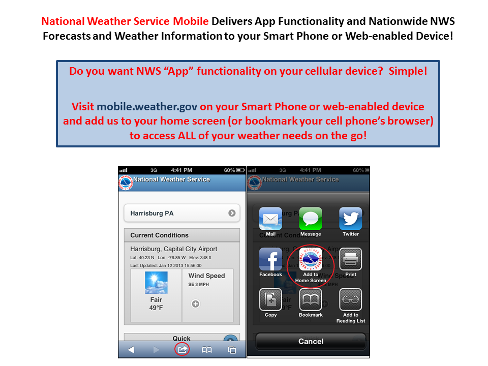
CLICK ON THE IMAGE BELOW TO USE THE NWS MOBILE WEB APP
|


 Send Us a Report