Lake Effect Summary - November 19-21, 2014
|
|
|
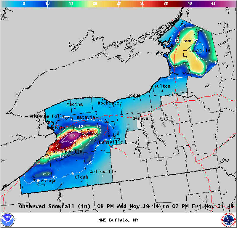
Maximum Snowfall: Lake Erie 49" (Wales Center); Lake Ontario 22.4" (Highmarket) Duration: 48 hours +/- Flake Scale: 5 flakes***** A very favorable climatological pattern for heavy lake effect snow was in place over the lower Great Lakes Wednesday and Thursday, Nov 19 and 20, as a deep closed H5 low was centered near the Michigan Straits while anomalously cold air was over the upper Ohio Valley and Mid West. At the surface, low pressure over the Upper Great Lakes Wednesday afternoon tracked across Southern Ontario to the Ottawa Valley by Thursday morning… then to the St Lawrence Valley by Thursday evening. This synoptic pattern circulated H85 temps of -14c across the lower Great Lakes to produce moderate to extreme instability over the relatively mild lake waters. The building instability was accompanied by a capping inversion that rose from around 7k feet at the start of the event to around 15k feet at its peak. This was all very conducive for the second straight lake effect event in less than 48 hours. Starting with the activity off Lake Erie… Lake effect snow blossomed over Eastern Lake Erie and Southern Ontario Wednesday evening on a 220 flow. Cloud to ground lightning was noted near Long Point near the onset of the activity. As the cold air deepened and low level winds veered to 240, the lake band pivoted east and aligned itself with Lake Erie, allowing it to take full advantage of heat and moisture fluxes from the full fetch of the lake. The somewhat cellular band intensified into a solid plume of moderate to heavy lake snow, producing more thundersnow (in the Buffalo area) process. In the vicinity of the lightning, dual pol imagery depicted a wealth of graupel around 4k feet (nr -10c), which just happened to be in the heart of the mixed phase portion of the lake cloud. The band temporarily settled south to the Chautauqua County lake shore to the Buffalo southtowns to Southern Genesee County by midnight…very close to the where the momentous lake snow storm took place 24 to 48 hours earlier. During overnight, the band drifted back north to the Buffalo metropolitan area with enhanced cells producing another round of thunder snow. Unlike the epic event of the previous couple days, this snow band oscillated back and forth for the remainder of the event…drifting south by daybreak across Southern Erie County (about 10 miles south of the heaviest snow from the previous storm) and extending across Wyoming County before arching back to the north to the immediate southern suburbs of Buffalo for a couple hours Thursday afternoon. The lake band was very well organized from late Wednesday night through much of Thursday, with IR satellite imagery indicating that there were abundant overshooting tops within the bands where some cloud tops (-35C) exceeded the cap by some 5k ft. The intensity of the band was also evident from the 2 to 4 inch per hour snowfall rates. This enabled the event to produce snowfall amounts of up to 4 feet across parts of Southern Erie County and Wyoming County. The moderate to heavy snow extended east across Livingston and Ontario counties as well…with accumulations approaching a foot over northern Livingston County. After the passage of a couple of reinforcing secondary cold fronts late Thursday afternoon and evening, the low level flow veered to the northwest, and this pushed the lake snows into the southern tier where increased shear and a shorter fetch broke the solid plume of snow into multiple bands. Snowfall amounts across the Western Southern Tier generally ranged from 6 to 12 inches with slightly higher amounts over the hilltops. Off Lake Ontario… As is usually the case, the lake effect snow was 3 to 6 hours later in developing than that off Lake Erie. The band initially started over Kingston and parts of southern Quebec shortly after midnight Wednesday night, then as the 220 flow veered to 240 during the wee hours of the morning, the band shifted south and east across Jefferson County. By daybreak Thursday, twin bands of moderate to heavy snow were found east of Lake Ontario, with one centered over northernmost Jefferson County and the other over the northern slopes of the Tug Hill and northern Lewis County. As the southern band pushed south off the lake during the course of Thursday morning, the northern band drifted south to the northern slopes of the Tug Hill (southern Jefferson County to northern Lewis) where it remained nearly stationary through the course of the afternoon. Unlike the plume of heavy snow off Lake Erie, there was only limited lightning generated from the band off Lake Ontario, and that came over the Tug Hill Plateau. There is a suggestion that this lightning may have had some help from the orographic lift, as there was no lightning with the band when it was north or south of the Tug Hill. A solid band of heavy lake snow was found over the Tug Hill Thursday evening, then the activity drifted south across Oswego and southernmost Lewis County during the remainder of the night. Snowfall rates of 2 to 4 inches an hour helped to produce an average of a foot to a foot and half of snow within this band leading up to daybreak Friday…at which point the lake effect had weakened and become multi band in nature over Oswego and Northern Cayuga counties. The lake effect remained multi band in nature Southeast of Lake Ontario through midday Friday while continuing to weaken to nuisance lake streamers. Little additional snow accumulations were reported during the daylight hours Friday.
|