Good Morning!
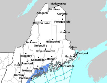
***Rain/Snow Showers Along the Coast Today. Snow Showers for Interior Downeast***
Expect precipitation to begin late morning and continue through early tonight. Any snow accumulation should remain under an inch.
***Cold returns Sunday through Tuesday***
Arctic air moves into the region early next week bringing a return of highs in the teens and lows near 0 degrees. The coldest day will be Monday and blustery winds may make it feel colder.
***A round of light snow in the Downeast/Bangor region Sunday night - Monday morning***
Light snow accumulation of 1 to 2 inches is possible with this system. Some minor impacts to travel from slippery roads possible during the Monday morning commute.
For more information, please visit weather.gov/car
This general weather briefing slide is updated daily in the early AM hours before 7am (slide update time at bottom right of slide). It may not be updated as conditions change.For high-impact events, more detailed information will be provided via traditional decision support services.
This is the home page for emergency managers to do a self briefing. For information on a particular hazard, just click on the appropriate orange link above.


 Coastal Flood