|
TYPE OF ISSUANCE
|
WHAT IS EXPECTED TO OCCUR
|
CONF. LEV.
|
|
|
Severe Weather Products
|
|
|
Tornado Warning
|
Likelihood of a tornado within the given area based on radar or actual sighting; usually accompanied by conditions indicated above for "Severe Thunderstorm Warning"
|
N/A
|
|
Severe Tstm Warning
|
Thunderstorms with wind gusts ≥ 58 mph (50 kts) AND/OR hail ≥1" in diameter
|
N/A
|
|
Special Marine Warning
|
Special Marine Warnings is issued for short-duration (up to 2 hours) sustained marine thunderstorm winds or associated gusts of 34 knots or greater; and/or hail 3/4 inch (penny) or more in diameter; and/or waterspouts.
|
N/A
|
|
Special Weather Statement
|
SPSs should be issued for ongoing or imminent weather conditions less than warning criteria and to report funnel clouds. SPSs should be issued to report funnel clouds which are not expected to touch the ground and become tornadoes. SPSs may be issued for severe weather outlook information.
|
N/A
|
|
|
Winter Weather Products
|
|
|
Winter Storm Watch
|
Conditions are favorable for a Winter Storm event (Heavy Sleet, Ice Storm, Heavy Snow, and Blowing Snow or a combination of events) to meet, or exceed, local Winter Storm Warning criteria in the next 12 to 48 hours.
|
50%
|
|
Blizzard Warning
|
Sustained wind or frequent gusts greater than or equal to 35 mph accompanied by falling and/or blowing snow, frequently reducing visibility to less than 1/4 mile for three hours or more.
|
80%
|
|
Ice Storm Warning
|
Ice accumulation of ½ (one half) inch or more.
|
80%
|
|
Winter Storm Warning
|
Winter weather event having more than one predominant hazard (i.e., heavy snow and blowing snow, snow
and ice, snow and sleet, sleet and ice, or snow, sleet and ice) that leads to significant travel issues or minor power outages due to ice accretion on trees.
|
80%
|
|
Snow Squall Warning
|
Heavy Snow reducing visibility to less than one quarter mile, along with wind gusts >34 mph and rapidly falling temperatures resulting in a high likelihood of a flash freeze.
|
80%
|
|
Winter Weather Advisory
|
Winter weather event where mixed precipitation (i.e., snow and ice, snow and sleet, or snow, ice and sleet), blowing snow, snowfall or light freezing rain will cause travel impacts.
|
80%
|
| Special Weather Statement | Issued for winter events that do not meet advisory or warning criteria. Some examples: strong areas of snow showers that are less severe than snow squalls, blowing snow causing patchy travel impacts, or black ice formation. | |
|
|
Non-Precipitation Weather Products
|
|
| High Wind Watch | Issue a High Wind Watch for high winds excluding those directly associated with severe local storms, hurricanes, and winter storms for a) sustained wind speeds of 40mph or greater lasting for 1 hour or longer, or b) winds of 58 mph or greater for any duration. |
50% |
| High Wind Warning | Issue a High Wind Warning for high winds excluding those directly associated with severe local storms, hurricanes, and winter storms for a) sustained wind speeds of 40 mph or greater lasting for 1 hour or longer, or b) winds of 58 mph or greater for any duration. | 80% |
| Wind Advisory | Issued for winds excluding those directly associated with severe local storms, tropical cyclones, and winter storms for a) sustained wind speeds of 31-39 mph lasting for 3 hours or longer; or b) wind gusts of 46-57 mph. | 80% |
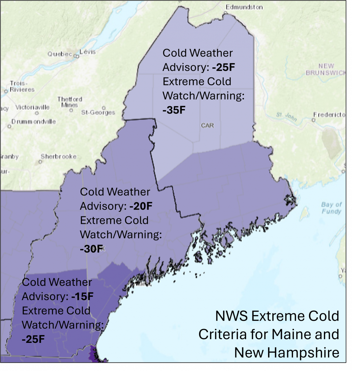
| Extreme Cold Watch |
Dangerously cold air temperatures or wind chill values are possible in the next 12 to 48 hours.
|
50% |
| Extreme Cold Warning | Dangerously cold air temperatures or wind chill values are expected in the next 12 to 36 hours or occurring now.
|
80% |
| Cold Weather Advisory |
Issued when potentially dangerous cold air temperatures or wind chill values are expected or occurring.
|
80% |
| Excessive Heat Watch | Heat index likely to reach 105°F or greater for 2 hours or more in the next 12 to 48 hours | 50% |
| Excessive Heat Warning | Issued when the heat index is expected to reach 105°F or greater lasting for 2 hours or more. | 80% |
| Heat Advisory | Issued when the heat index is expected to reach 95 degrees lasting 2 hours or more or 100-104°F for any amount of time. | 80% |
|
Freeze Watch
|
Issue a Freeze Watch when the minimum temperature is forecast to be 32F or less during the frost/freeze season. The season begins on the average date of the last spring freeze and ends on the date of the first hard autumn freeze.
|
50%
|
|
Freeze Warning
|
Issue a Freeze Warning when the minimum temperature is forecast to be 32F or less during the frost/freeze season. The frost/freeze season begins on the average date of the last spring freeze and ends on the date of the first hard autumn freeze. |
80%
|
| Frost Advisory | Issued when the minimum temperature is forecast to be 33F to 36F with light wind and mostly clear skies during the frost/freeze season. The frost/freeze season begins on the average date of the last spring freeze and ends on the date of the first hard autumn freeze. |
80% |
|
Dense Fog Advisory
|
Dense Fog Advisory Issued when widespread or localized fog reduces visibilities to 1/4 mile or less.
|
80% |
|
Dense Smoke Advisory
|
Issued when widespread or localized smoke reduces visibilities to 1/4 mile or less.
|
80% |
|
Freezing Fog Advisory
|
Issued for very light ice accumulation from freezing fog.
|
80% |
|
|
Marine/Coastal Products
|
|
|
Coastal Flood Watch
|
Issued when conditions are favorable for a coastal flood event to develop over part or all of the local coastal area, but the occurrence is uncertain.
|
50%
|
|
Coastal Flood Warning
|
Issued when hazardous coastal flooding is imminent, occurring or highly likely over part or all of the local coastal area. Includes significant beach erosion, destructive wave action and inundation >= 2 feet.
|
80%
|
|
Coastal Flood Advisory
|
Issued when minor coastal flooding is imminent, occurring or highly likely over part or all of the local coastal area. Includes minor beach erosion, splash-over or inundation up to 1 foot.
|
80%
|
|
Coastal Flood Statement
|
Issued when splash-over from wave action is expected on exposed coastal roadways. |
80%
|
|
Small Craft Advisory
|
Sustained winds ranging between 25 and 33 knots (except 20 to 25 knots, lower threshold area dependent, to 33 knots for harbors, bays, etc.) and/or seas/waves 5 to 7 feet and greater, area dependent.
|
N/A
|
|
Gale Warning
|
A warning of sustained surface winds, or frequent gusts, in the range of 34 knots (39 mph) to 47 knots (54 mph) inclusive, either predicted or occurring, and not directly associated with a tropical cyclone.
|
N/A
|
|
Storm Warning
|
A warning of sustained surface winds, or frequent gusts, in the range of 48 knots (55 mph) to 63 knots (73 mph) inclusive, either predicted or occurring, and not directly associated with a tropical cyclone.
|
N/A
|
|
Hurricane Force Wind Warning
|
A warning for sustained winds, or frequent gusts, of 64 knots (75 mph) or greater, either predicted or occurring, and not directly associated with a tropical cyclone.
|
N/A
|
|
Freezing Spray Advisory
|
An advisory for an accumulation of freezing water droplets on a vessel at a rate of less than 2 centimeters (cm) per hour caused by some appropriate combination of cold water, wind, cold air temperature, and vessel movement.
|
N/A
|
|
Heavy Freezing Spray Warning
|
A warning that may be issued within the Coastal Waters Forecast. An accumulation of freezing water droplets on a vessel at a rate of 2 cm per hour or greater caused by some appropriate combination of cold water, wind, cold air temperature, and vessel movement.
|
N/A
|
|
High Surf Advisory
|
For Waves 7ft or greater OR 5ft or greater with period of 10 seconds or longer. Issued Memorial Day weekend through Columbus Day weekend.
|
N/A
|
|
Rip Current Statement
|
For rip current risk of High without meeting High Surf Criteria. Issued Memorial Day weekend through Columbus Day weekend.
|
N/A
|
|
|
Tropical Cyclone Products
|
|
|
Hurricane Local Statement
|
WFO Caribou will issue HLSs when its area of responsibility is affected by a tropical cyclone watch/warning or evacuation orders. HLSs may also be issued as needed to dispel rumors or to clarify tropical cyclone related information for their CWA. Inland counties may be included in the HLS as an option.
|
N/A
|
|
Extreme Wind Warning
|
EWW is a short term product issued when winds a) Tropical cyclone is a category 3 or higher AND b) sustained tropical cyclone winds of 100kts or greater are occurring or expected to occur within 1 hour
|
N/A
|
|
|
Flood/Flash Flood Products
|
|
|
Areal Flood Watch
|
Areal flood watches will be issued when one or more of the following conditions are met: b. The possibility exists for meteorological, soil, and/or hydrologic conditions to lead to flooding more than 48 hours into the future and the forecaster determines that the flood watch is the best way to convey this possibility; or c. A dam or levee may fail and threaten lives or property, but the threat is not deemed to be imminent, or d. The effective time of a previously issued flood watch changes; and/or e. The geographic area covered by a previously issued flood watch increases; and/or f. An update to a previously issued flood watch is required; and/or g. A cancellation of all or part of a previously issued flood watch is required; and/or h. The expiration of a previously issued flood watch is to be announced (optional). |
N/A
|
|
Flash Flood Warning
|
Issued when: a) flash flooding is reported; b) precipitation capable of causing flash flooding is indicated by radar, gage reports, and/or satellite; c) local tools indicate flash flooding is likely; d) an existing flash flood warning is expiring and needs to be extended; e) the area covered by an existing flash flood warning increases; or f) a dam failure, or failure of a naturally caused stream obstruction (debris slide, ice jam) is imminent or occurring. |
N/A
|
|
Flood Warning (River Forecast Points) |
FLOOD WARNING issued for river forecast point locations when a) flood monitoring and prediction tools and/or RFC guidance indicate a river forecast point will crest at or above flood stage, or b) when flooding is reported, or c) when an existing Flood Warning is expiring and needs to be extended, or d) when the area e) the magnitude of flooding changes category (e.g. minor to moderate, etc.). |
N/A
|
|
Flood Warning (County Based) |
FLOOD WARNING issued for counties or portions of counties when a) flood monitoring and prediction tools and/or RFC guidance indicate flooding is likely, or b) when flooding is reported, or c) when an existing Flood Warning is expiring and needs to be extended, or d) when the area covered by an existing Flood Warning increases, or e) the magnitude of flooding changes category (e.g. minor to moderate, etc.). |
N/A
|
|
Flood Statement (Flood Advisory) |
FLOOD STATEMENT issued to a) issue an advisory for non-threatening, nuisance flooding of streams and ponding of water on roads or in urban areas; or b) to update an existing advisory; or c) to cancel an existing advisory. |
N/A
|
|
Fire Weather Products
|
||
| Fire Weather Watch |
Critical Fire Weather Conditions are possible within the next 48hrs Criteria: Relative humidity < 30% and sustained winds or frequent gusts >25 mph for 3 or more hours along with 1 and 10 hour fuel conditions < 10% |
50% |
| Red Flag Warning |
Critical Fire Weather Conditions are expected within the next 24hrs Criteria: Relative humidity < 30% and sustained winds or frequent gusts >25 mph for 3 or more hours along with 1 and 10 hour fuel conditions < 10% moisture |
80% |
| Fire Weather Special Weather Statement |
Elevated Fire Weather Conditions within the next 24hrs Fire weather conditions are below critical fire weather conditions and/or 1 and 10 hour fuels moisture criteria is above 10%, but conditions still warrant notification of possible fire weather concerns |
N/A |


 Coastal Flood
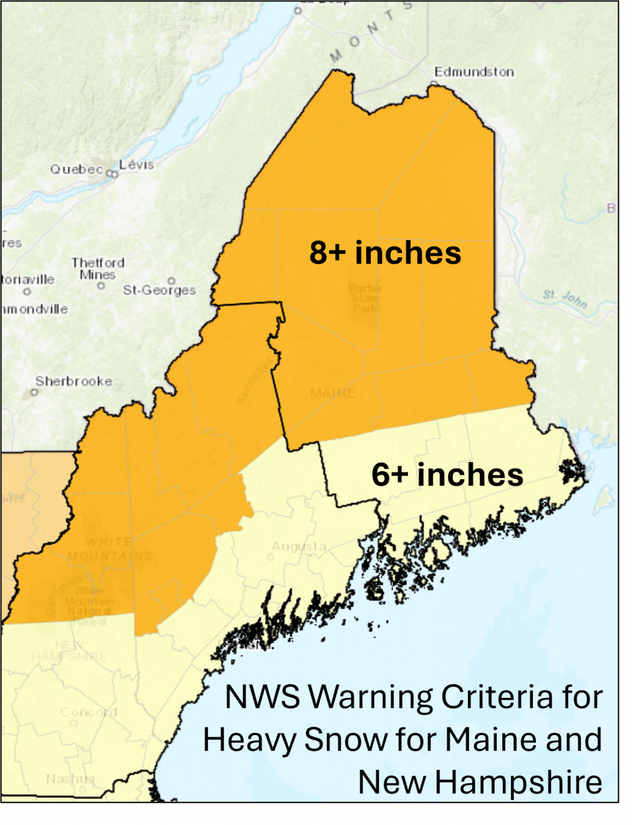