|
Widespread flooding occurred on February 28th when heavy rain, thunderstorms, and a rapid snow melt occurred. The flooding was severe in many areas, in some cases, the equivalent of a 100 year flood!
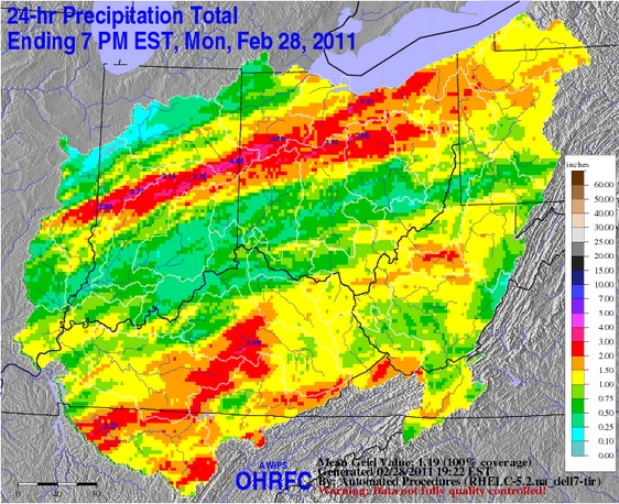
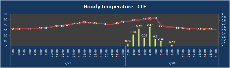
The stage was set for potential flooding earlier in February. A thaw in mid February melted much of the winter snow causing saturated grounds. On February 25th, 5-10 inches of heavy wet snow blanketed the area. Around an inch of liquid water was held in the snow pack, with locally up to two inches of water equivalent. During the early morning hours on February 28th, most of the snow had melted as temperatures soared into the 50s. Heavy rain and thunderstorms accompanied the warm-up. The region experienced a transition from snow and cold to summer-like weather conditions in only a matter of 2 to 3 days! Rainfall averaged one and a half to two and a half inches in about 6 hours. The combination of saturated soil, rapid snow melt, and heavy rain swelled streams and creeks, and for some, to near record levels in just a few hours.
The following images showing approximate snow depths and snow water equivalents on Feburary 27th are from the National Operational Hydrologic Remote Sensing Center. Modeled Total Snow Depth for 2011 Feb 27, 7 AM
Modeled Snow Water Equivalent for 2011 Feb 27, 7 AM
One to two inches of water was within the snowpack leading up to the flooding. With the potential for moderate to heavy rainfall, a flood watch was issued early on Sunday (27 Feb, 2011) indicating that significant flooding was possible if heavy rain occcured. During a 24-hour period starting Saturday night (26 Feb, 2011), temperatures were above freezing and dewpoints rose above freezing. Heavy rain moved into the area Sunday night with nearly continuous thunderstorms. In about a 6-hour period, 2 to 3 inches of rain fell. The combination of 1 to 2 inches of liquid equivalent with the snow melt and 2 to 3 inches of rain led to a rapid runoff and a sudden rise in water.
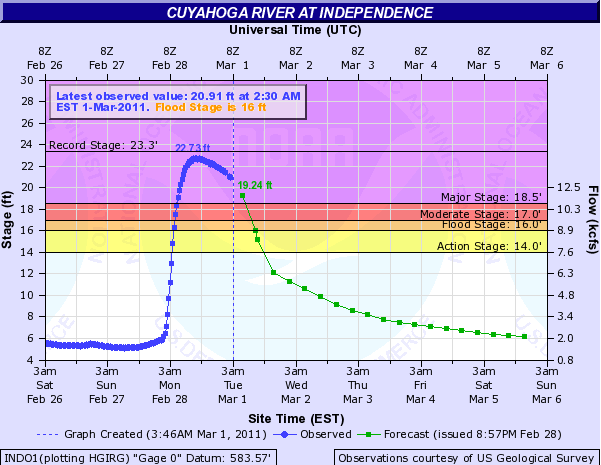
Nearly all of the northern Ohio and northwest Pennsylvania river points went into flood by daybreak Monday. Many of the quick responding rivers jumped into major flood status within hours. The Cuyahoga River at Independence moved from low flow, above the 14 feet to the flood stage in a couple of hours, then to major flood stage of 18.5 feet in just 2 more hours! The Cuyahoga River at Independence crested at 22.7 feet Monday, near the all time high of 23.3 feet from 2006..
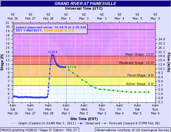
It took the Grand River at Painesville less than 6 hours to rise to a major flood stage of 13 feet. Flood stage at Painesville is 8 feet and the river crested at 13.3 feet Monday.
Check out all the gauged river stages on our web page (River and Lakes AHPS) at: https://water.noaa.gov/wfo/CLE. Inundation maps are now available for the Blanchard River at Findlay and the Killbuck Creek at Killbuck. Other inundation maps are planned. You can find the inundation maps at the AHPS web sites - click on the "Inundation Mapping" tab at the top of the page. Click here for the Findlay inundation map.
National Flood Safety Week is March 14-18, 2011. The National Weather Service Flood Safety Page has great information for you and your family.
The National Weather Service Ohio River Forecast Center is a great source of hydrologic information. Have any pictures, information, or stories of the flooding? Send them to the National Weather Service in Cleveland.
|