|
Republican River Flood of 1935 A Closer Look at McCook, Nebraska
Amount of Rain Measured - 2.45 inches on May 31, 1935 Time Flood Impacted McCook- 1 pm, river crested River Depth at McCook- West of McCook-14 feet, East of McCook-29 feet River Width at McCook- 2.20; West of town-1.61 feet, East of town-0.78 feet Normal / Flood Width of River- East of McCook- 225 / 8500 feet
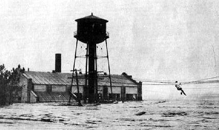
The man on the wire at the Light and Power Plant, Robert H French. Photo from Nancy McKenzie. Click here to read the article from the McCook Gazette on Monday, September 10, 2007 "The Man in the famous photo".
From Swept Away: From Nebraskaland, June 1971. "Great Flood of 1935," by William H Spencer In McCook...most residents were unaward of the impending dander since communications were cut off. Power went off, generating facilities were inundated. Some itilities officials did know the water was coming and took stepts to protect the town. The manager of the city light plant threw crews into constructing a sandbag dike to divert the water. The light plant was located close to the river and was a vunerable target. The move was too late. Whent he water hit, 37 men were working there and were trapped. As the water rose in the building, they were forced to move to the rood. They could not be rescued vby boat as the water was moving too fast. After considerable deliberation, men on shore decided to try a rescue using power lines which radiated from the station. Paul Wilson shinnied along the elctric wires carrying a line. A large roade connect to the line was pulled to the powerhouse, then secured at both ends. The plan was to attach a pulley to the rope and get the men ashore by having them swing from pole to pole. Bob French, one of the stranded men, climbed out to the nearest pole of the power plant while Ray Miller made for the pole nearest the shore to help those evacuated. Two men were quickly gotten to shore, although it was hard work. The weather didn't make things easier. Miller climbed down for a break. The poles yielded to the raging waters. French on his perch had two choices - sink or swim. He chose to swim. As the wires and poles toppled, he stood up and dived over the wires into the swirling cataract. He was under water for what seemed an enternity. Those on shore had almost given him up when he finally surfaced. Bobing downstream, he struck out for shore, dodging drift wood and floating debris as he swam. Finally he pulled himself to safety. His ordeal was over, but there were still men in the light plant. Water continued to gnaw away at the building. A standpipe beside the powerhouse swayed gently, then plunged into the water, scraping the wall of the building as it fell. Weakened by the constant pounding water, the building sagged in the middle and the steel frame buckeld and the roof collaspsed in the center. In spite of it all, the building held. From Swept Away: An account by Frank and Hazel T. Hoyt and family Saturday the water began to recede. We were able to walk out to the west river bridge which stayed in. It had been condemned by the County Board some time before and now was the only bridge left between Max and Oxford across the Republican. At the farm we found the wheat crop, except for fove acres, was hailed out including 110 acres of good summer fallow that would have yeilded 40 bushels per acre. Thirty acres of alfalfa was a total loss. Fences across the Driftwood were washed away. Cattle were running loose. Six acres of new hog wite fence was washed down a clump of trees and mixed with dead trees, much and mud. It was three weeks before we could drive the car and truck from McCook to te farm. Buildings, fruit trees, shade trees and garden were all damaged by hail.
McCook Gazette, June 3 or 4, 1935 River Goes Back to Peace Habits, But on Either Side of Its Banks are Evidences of Its Mad Caprice. Flying over the valley up the river from Red Willow, over scences of utter desolation. As far as the eye could see, the Burlingto rails were thrown off grades and roadbeds destroyed. Farms have been swept clear of buildings. Fields are coated with a horrid slime which will be weeks in drying. Ravenswood Dairy (McCook) were lives were taken sagged on its foundation. Of Pastime Park only the residence was left. The dance pavilon and cabins are gone. No evidence there had been a swimming poill. In the channel like a weary saffron same, the Republicn crawled laizily down the valley, its strength spent. It was back in its banks. On the far horizon dust clouds played.
Depth of water 1 mile west of Ravenswood Dairy on June 10,1935.
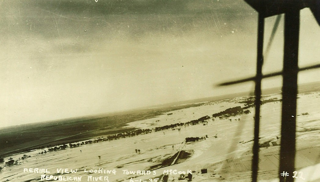
Aerial View Looking toward McCook on June 1, 1935.
Railroad bridge washed out near McCook.
Bridge Washed out near McCook.
May 1935 - pdf June 1935 - pdf River Flow Graphs
|