National Weather Service United States Department of Commerce
Click a location below for detailed forecast.

Last Map Update: Tue, May. 7, 2024 at 3:05:03 am CDT

National Weather Service Tulsa, OKNational Weather Service Springfield, MONational Weather Service Paducah, KY
National Weather Service Norman, OKZoom
Out

National Weather Service Memphis, TN
National Weather Service Fort Worth/Dallas, TXNational Weather Service Shreveport, LANational Weather Service Jackson, Mississippi

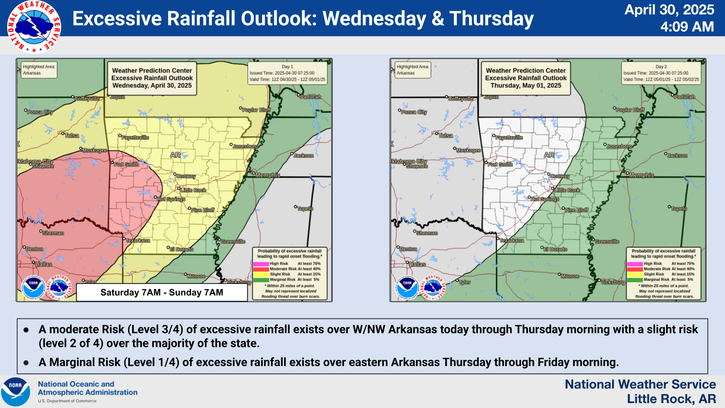
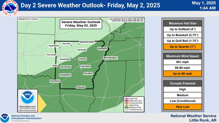
There is a potential for severe weather the next three days. The greatest risk of severe storms will be on Wednesday.
Scattered severe thunderstorms will become likely during the afternoon/evening hours on Wednesday. Very large hail and damaging wind will be the main concerns, and isolated tornadoes may be spawned.
A line of strong to severe thunderstorms will head toward Arkansas from the Plains Monday night, and will approach the northwest corner of the state by midnight CDT. The storms are expected to weaken as they move across the northern/western counties during the predawn hours Tuesday.
Storm systems ("L") in the central/southern Plains will track toward the mid-Mississippi and Ohio Valleys. The systems will drag a cold front into a very warm/humid environment in Arkansas. This will result in scattered to numerous thunderstorms across the region, with severe weather likely.
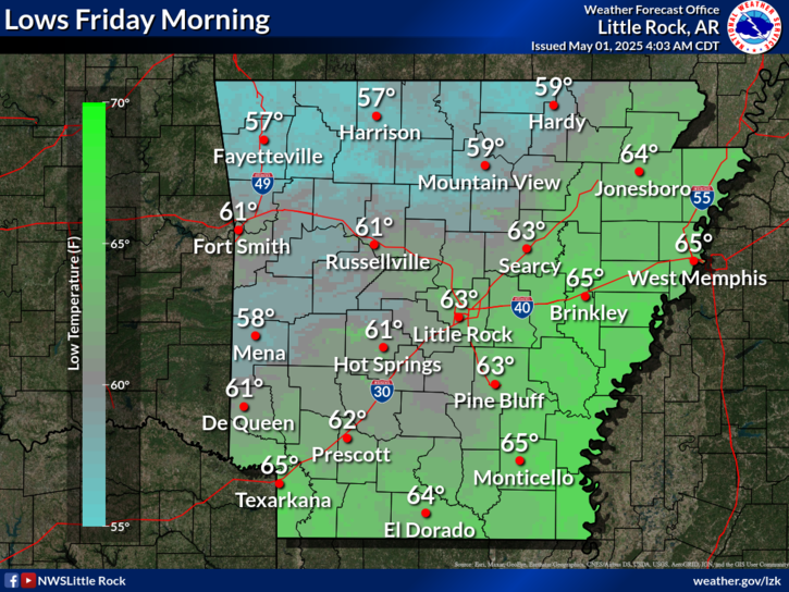
Forecast low temperatures are expected to drop into the mid 60s to lower 70s across the state for your Tuesday morning.

 
Hourly Weather Roundup ( )
Location Sky/Weather Temp Dewpt RH Wind Baro Remarks
Fayetteville
N/A
N/A
N/A
N/A
N/A
N/A
N/A
Harrison
N/A
N/A
N/A
N/A
N/A
N/A
N/A
Mountain Home
N/A
N/A
N/A
N/A
N/A
N/A
N/A
Jonesboro
N/A
N/A
N/A
N/A
N/A
N/A
N/A
Fort Smith
N/A
N/A
N/A
N/A
N/A
N/A
N/A
Russellville
N/A
N/A
N/A
N/A
N/A
N/A
N/A
Mount Ida
N/A
N/A
N/A
N/A
N/A
N/A
N/A
Hot Springs
N/A
N/A
N/A
N/A
N/A
N/A
N/A
Little Rock
N/A
N/A
N/A
N/A
N/A
N/A
N/A
North Little Rock
N/A
N/A
N/A
N/A
N/A
N/A
N/A
West Memphis
N/A
N/A
N/A
N/A
N/A
N/A
N/A
Texarkana
N/A
N/A
N/A
N/A
N/A
N/A
N/A
El Dorado
N/A
N/A
N/A
N/A
N/A
N/A
N/A
Pine Bluff
N/A
N/A
N/A
N/A
N/A
N/A
N/A
Monticello
N/A
N/A
N/A
N/A
N/A
N/A
N/A
Note: "N/A" or "MISG" will be displayed if values are not available. In the LOCATION column, click on links for a list of recent observations at sites of interest. In the WIND column, VRB is "variable" and G is "gust". Wind speeds are in MPH. In the BARO (pressure) column, values are in inches. In the REMARKS column, HX is "heat index", WCI is "wind chill index", and VSB is "visibility" (if shown).
 
 
Point Forecasts
Cities in Arkansas Coordinates (make sure "Lon" is negative)
Lat:   Lon:
 
Local Hazards
Local Hazards
Decision Support
Decision Support
Submit Storm Report
Submit Storm Report
Local Forecast Page
Local Forecast Page
Radar Links
Radar Links
Local Climate Page
Local Climate Page
Local Observations Page
Local Satellite Page
Local Drought Page
Local Drought Page
Local Hydrology Page
Local Fire Page
Local Fire Page
Text Product Viewer
Text Product Viewer