HOME
FORECAST
Local
Graphical
Aviation
Marine
Rivers and Lakes
Hurricanes
Severe Weather
Fire Weather
Sunrise/Sunset
Long Range Forecasts
Climate Prediction
Space Weather
PAST WEATHER
Past Weather
Astronomical Data
Certified Weather Data
SAFETY
INFORMATION
Wireless Emergency Alerts
Weather-Ready Nation
Brochures
Cooperative Observers
Daily Briefing
Damage/Fatality/Injury Statistics
Forecast Models
GIS Data Portal
NOAA Weather Radio
Publications
SKYWARN Storm Spotters
StormReady
TsunamiReady
Service Change Notices
EDUCATION
NEWS
SEARCH
Search For
NWS
All NOAA
ABOUT
About NWS
Organization
For NWS Employees
National Centers
Careers
Contact Us
Glossary
Social Media
NWS Transformation
Local forecast by
"City, St" or ZIP code
Sorry, the location you searched for was not found. Please try another search.
Multiple locations were found. Please select one of the following:
Location Help
News Headlines
Virtual Winter Weather Skywarn available Saturday, December 13
Customize Your
Weather.gov
Enter Your City, ST or ZIP Code
Remember Me
LOADING...
Raleigh, NC
Weather Forecast Office
satellite
Weather.gov
>
Raleigh, NC
> satellite
Current Hazards
River Flooding
Briefing Page
Space
Winter
Local Outlook
Drought
Thunderstorms
Hurricanes
Current Conditions
Rainfall
Observations (List)
Air Quality
Satellite
Observations (Map)
Southeastern US Satellite Imagery
Statewide Observations Table
Radar
Local KRAX Standard Radar (low bandwidth)
Local KRAX Enhanced Radar
Regional Standard Radar (low bandwidth)
National Standard Radar (low bandwidth)
Forecasts
Forecasters' Discussion
Aviation
Tropical
Map View
Hourly View
Fire Weather
Marine
Probabilistic Rain Forecast
Snow and Ice Forecasts / Snow Probabilities
WFO RAH Forecast Suite
Rivers and Lakes
Current & Past Streamflow
Ensemble River Guidance
River Observations (Map)
River Forecast Centers
River Forecasts (Map)
Local Hydrographs
Local MMEFS (Ensemble River Guidance) Page
Recreational Forecast for Central NC Lakes
Local Products
Climate and Past Weather
Past Observed Weather
Past Rainfall
CoCoRaHS
24 Hour Summary
Snowfall Records
Drought Outlook
Climate Prediction
Graphical Climate Plots and Daily Max/Min/Precip Maps
RDU Daily Normals
GSO Daily Normals
FAY Daily Normals
Frost/Freeze Information and Climatology
Tropical Cyclone Reports
Local Programs
P-Type Nomograms / Partial Thicknesses
Excessive Heat Danger Awareness
Wet Bulb Globe Temperatures
Satellite Data
GOES-12 Overview Sectors:
Special Raleigh/Central North Carolina Sector
Eastern U.S. Sector
Mid-Atlantic Sector
GOES-12 Eastern United States:
Eastern US 4-km Visible
Eastern US 8-km Visible
Southeast High Resolution Visible
Large Domain High Resolution Visible
Eastern US 4-km Infrared (IR)
Eastern US 8-km Infrared (IR)
Southeast High Resolution Infrared (IR)
Large Domain High Resolution Infrared (IR)
GOES-12 enhancement #1
GOES-12 enhancement #2
GOES-12 enhancement #3
GOES-12 enhancement #4
Eastern US 4-km Water Vapor
Eastern US 8-km Water Vapor
Large Domain High Resolution Water Vapor
GOES-12 enhancement #1
GOES-12 enhancement #2
GOES-12 enhancement #3
GOES-12 enhancement #4
Atlantic Ocean and Gulf of America:
Northwestern Atlantic Visible
Northwestern Atlantic Visible Loop
Northwestern Atlantic Infrared (IR) Loop
Northwestern Atlantic Infrared (IR)
Northwestern Atlantic Water Vapor Loop
Northwestern Atlantic Water Vapor
Western Atlantic / Caribbean Visible
Western Atlantic / Caribbean Visible Loop
Western Atlantic / Caribbean Infrared (IR)
Western Atlantic / Caribbean Infrared (IR) Loop
Western Atlantic / Caribbean Water Vapor
Western Atlantic / Caribbean Water Vapor Loop
Gulf of America Visible
Gulf of America Visible Loop
Gulf of America Infrared (IR)
Gulf of America Infrared (IR) Loop
Gulf of America Water Vapor
Gulf of America Water Vapor Loop
Eastern Atlantic Visible
Eastern Atlantic Visible Loop
Eastern Atlantic Infrared (IR)
Eastern Atlantic Infrared (IR) Loop
Eastern Atlantic Water Vapor
Eastern Atlantic Water Vapor Loop
GOES Storm Floater 1 Visible
GOES Storm Floater 1 Visible Loop
GOES Storm Floater 1 Infrared (IR)
GOES Storm Floater 1 Infrared (IR) Loop
GOES Storm Floater 1 Water Vapor
GOES Storm Floater 1 Water Vapor Loop
GOES Storm Floater 2 Visible
GOES Storm Floater 2 Visible Loop
GOES Storm Floater 2 Infrared (IR)
GOES Storm Floater 2 Infrared (IR) Loop
GOES Storm Floater 2 Water Vapor
GOES Storm Floater 2 Water Vapor Loop
Other Assorted Imagery:
Severe Storms and Special Events Imagery
Full Disk Visible
Full Disk Infrared (IR)
Other Satellite Imagery:
GOES Satellite Server
Satellite Services Division
Operational Significant Event Imagery
- Daily Significant Event Imagery
NASA Satellite Server
NASA Interactive Global Geostationary Weather Satellite Images
Space Science and Engineering Center Images
GOES Derived Data
- This includes CAPE, Lifted Index and Precipitable Water, all derived from satellite data.
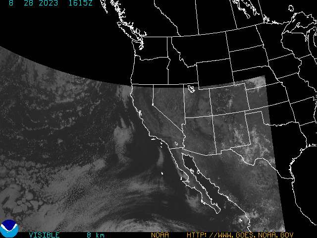
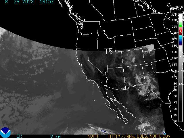
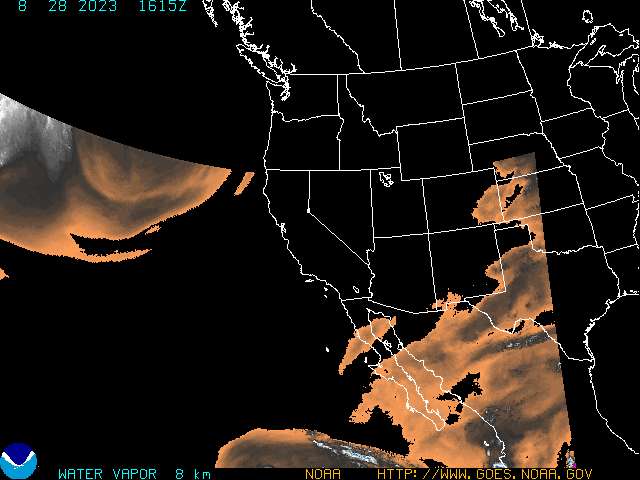
GOES-10 Western United States:
Visible
Infrared
Water Vapor
Radar
Current Weather
Rivers & Lakes
Satellite
Forecast Maps
Hour by Hour Forecast
Graphical Hazards
Winter Weather
Climate Plots
Fire Weather
Drought Information
Weather Hazard Briefing
Statewide Maps
Forecaster Discussion
Text Bulletins
SKYWARN
Follow us on X
Follow us on Facebook
Follow us on YouTube
RAH RSS Feed


 Statewide Maps
 Forecaster Discussion