Overview
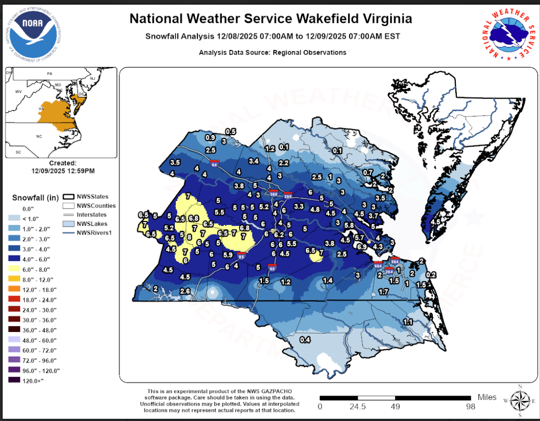
A sharpening shortwave aloft tracked over the area on December 8th as cool high pressure settled to our north. The surface high was in an ideal position for us to receive winter weather while weak low pressure gradually deepened off the Carolina coast. Widespread lift arrived during the morning of the 8th as the initial push of low-level cold air advection overspread the CWA. Precipitation was initially in the form of rain with surface temps in the mid 30s, but radar data showed that the melting layer was only 1000-1500 feet above the surface at ~9 AM. With CAA continuing throughout the day and latent cooling due to melting in the lowest levels, a quick changeover to snow was observed by late morning. While little accumulation was observed through 11 AM-noon (except in areas N/NW of Richmond where surface temps had fallen to 30-32F), snow continued. The snow picked up in intensity during the early afternoon as temperatures dropped just below freezing all the way down to the Wakefield office. A zone of moderately strong 850-700mb frontogenesis was observed over central VA, with banded snowfall and rates of 1-2"/hour observed from the south-central VA Piedmont to southern RIC Metro to interior SE VA from noon-4 PM. At the Wakefield office, 3.3" of snow fell from 1-3 PM! Only 0.21" of precipitation fell during that time, giving a snow/liquid ratio of 15:1 despite surface temps just below freezing. Farther north, a steadier light snow continued throughout the afternoon. Snowfall rates decreased during the evening with a steady light snow continuing through 7-10 PM. A corridor of 5-7" was observed from the south-central piedmont to Newport News, with a widespread 4-5.5" in the Richmond Metro. The 6.5" at the NWS Wakefield office was the highest storm total snowfall since 1/3/2018! Areas from Caroline County/Tappahannock NE saw little to nothing as the cold/dry air won out there.Snow/Ice
Photos
Header
| Caption (source) |
Caption (source) |
Caption (source) |
Caption (source) |
Radar
 |
| Loop of 0.5° Reflectivity/CC from 7 AM to 9 PM in 30 minute increments |
Storm Reports
Public Information Statement
National Weather Service Wakefield VA
1058 AM EST Tue Dec 9 2025

...SNOWFALL REPORTS FOR DECEMBER 8...

Location                     Amount    Time/Date       Lat/Lon

...North Carolina...

...Bertie County...
2 N Lewiston Woodville       0.4 in    0730 AM 12/09   36.14N/77.17W

...Pasquotank County...
1 NE Elizabeth City          1.1 in    0902 AM 12/09   36.31N/76.21W

...Virginia...

...Amelia County...
1 SW Jetersville             6.8 in    0742 PM 12/08   37.29N/78.10W
2 S Jetersville              6.5 in    1140 PM 12/08   37.27N/78.09W
Amelia Courthouse            5.5 in    1140 PM 12/08   37.34N/77.98W
2 S Giles Mill               5.0 in    0645 PM 12/08   37.45N/77.96W

...Brunswick County...
Alberta                      6.0 in    1140 PM 12/08   36.87N/77.88W
3 SW Ordsburg                5.9 in    0700 AM 12/09   36.94N/77.90W
2 SE Danieltown              5.0 in    0510 PM 12/08   36.89N/77.94W
Dolphin                      4.0 in    1140 PM 12/08   36.84N/77.79W

...Caroline County...
2 SSW Dawn                   2.2 in    0700 AM 12/09   37.81N/77.37W
3 N Burruss Corner           1.2 in    0800 AM 12/09   37.94N/77.42W
Penola                       0.1 in    0308 PM 12/08   37.96N/77.37W

...Charles City County...
2 SSW Mountcastle            3.3 in    1022 PM 12/08   37.43N/77.11W

...Chesterfield County...
Matoaca                      6.0 in    1140 PM 12/08   37.23N/77.48W
1 WSW Meadowville            6.0 in    0545 AM 12/09   37.36N/77.35W
3 SW Beach                   5.3 in    0700 AM 12/09   37.33N/77.64W
1 WNW Centralia              5.3 in    0700 PM 12/08   37.39N/77.48W
4 NE Winterpock              5.0 in    0634 PM 12/08   37.39N/77.67W
3 SSE Midlothian             5.0 in    0731 PM 12/08   37.47N/77.61W
Winterpock                   5.0 in    1140 PM 12/08   37.35N/77.72W
1 SSE Skinquarter            5.0 in    1140 PM 12/08   37.38N/77.77W
1 WSW Pocahontas State Park  5.0 in    1140 PM 12/08   37.37N/77.58W
2 NNE Matoaca                5.0 in    1140 PM 12/08   37.26N/77.47W
2 SSE Chester                4.5 in    0610 PM 12/08   37.33N/77.42W
1 NW Chester                 4.2 in    0830 PM 12/08   37.36N/77.44W
Chester                      4.0 in    1100 PM 12/08   37.35N/77.44W
Midlothian                   4.0 in    1105 PM 12/08   37.50N/77.64W

...City of Chesapeake County...
8 SW Chesapeake Airport      1.7 in    0800 AM 12/09   36.59N/76.44W
3 SSE Herberts Corner        1.5 in    0700 AM 12/09   36.69N/76.28W
1 ENE South Norfolk          1.0 in    0931 PM 12/08   36.80N/76.27W
1 NW Fentress                1.0 in    1030 PM 12/08   36.71N/76.19W

...City of Colonial Heights County...
1 WNW Colonial Heights       5.3 in    1105 PM 12/08   37.27N/77.41W
1 NE Colonial Heights        4.0 in    0556 PM 12/08   37.28N/77.39W

...City of Emporia County...
Emporia Reservoir            1.5 in    0700 AM 12/09   36.70N/77.56W

...City of Franklin County...
Hunterdale                   1.4 in    0738 PM 12/08   36.70N/76.96W

...City of Hampton County...
2 E Langley View             3.0 in    0800 PM 12/08   37.07N/76.33W
2 WSW Hallwood               3.0 in    0820 PM 12/08   37.06N/76.33W
2 SE Langley View            2.7 in    0648 PM 12/08   37.05N/76.34W

...City of Newport News County...
Oyster Point                 7.0 in    0754 AM 12/09   37.10N/76.51W
Menchville                   6.9 in    0648 PM 12/08   37.09N/76.53W
1 WNW Denbigh                5.7 in    0702 PM 12/08   37.13N/76.54W
1 ESE Newport News Golf      5.5 in    0916 PM 12/08   37.17N/76.53W
Denbigh                      5.3 in    0642 AM 12/09   37.12N/76.53W
1 W Menchville               5.0 in    0438 PM 12/08   37.09N/76.54W
2 NW Oriana                  4.8 in    0553 PM 12/08   37.15N/76.55W
1 WSW Beaconsdale            4.3 in    0700 AM 12/09   37.05N/76.49W
2 S Tabb                     4.0 in    0900 AM 12/09   37.10N/76.46W

...City of Norfolk County...
2 SE Norview                 0.8 in    1133 PM 12/08   36.87N/76.23W

...City of Petersburg County...
1 WNW Petersburg             6.6 in    1210 AM 12/09   37.21N/77.41W
1 W Petersburg               6.2 in    0500 PM 12/08   37.21N/77.41W

...City of Poquoson County...
1 ESE Poquoson               3.8 in    0806 PM 12/08   37.13N/76.36W

...City of Portsmouth County...
1 E Western Branch           2.0 in    0927 PM 12/08   36.82N/76.38W

...City of Richmond County...
2 N Downtown Richmond        3.8 in    0840 PM 12/08   37.57N/77.47W
2 N Downtown Richmond        3.3 in    0806 AM 12/09   37.56N/77.47W

...City of Suffolk County...
2 NNW Kilby                  3.0 in    1016 PM 12/08   36.75N/76.65W

...City of Virginia Beach County...
3 N London Bridge            2.0 in    0816 PM 12/08   36.88N/76.05W
2 SSW Gallups Corner         2.0 in    1013 PM 12/08   36.77N/76.14W
2 E Greenbrier               1.8 in    0818 PM 12/08   36.78N/76.17W
2 SW Princess Anne           1.5 in    0837 PM 12/08   36.73N/76.08W
2 N Sigma                    0.2 in    1104 PM 12/08   36.75N/75.99W

...Cumberland County...
Cumberland                   7.0 in    0620 AM 12/09   37.50N/78.24W
1 SSW Elk Hill               4.0 in    0508 PM 12/08   37.70N/78.09W

...Dinwiddie County...
Hebron                       7.0 in    1140 PM 12/08   37.15N/77.81W
Ford                         7.0 in    1140 PM 12/08   37.15N/77.73W
3 NNE Walkers                6.8 in    1031 PM 12/08   37.19N/77.69W
Wilsons                      6.5 in    0846 PM 12/08   37.14N/77.87W
1 NNW Addison                6.0 in    0624 PM 12/08   37.21N/77.51W
Sutherland                   5.5 in    1140 PM 12/08   37.20N/77.56W

...Essex County...
Tappahannock                 0.1 in    1004 PM 12/08   37.92N/76.87W

...Fluvanna County...
Columbia                     4.0 in    0709 PM 12/08   37.76N/78.16W
Hardware                     4.0 in    0800 PM 12/08   37.74N/78.40W
3 SSE Antioch                3.5 in    0800 AM 12/09   37.81N/78.40W

...Gloucester County...
1 WSW White Marsh            4.5 in    0717 PM 12/08   37.33N/76.54W
1 S Ware Neck                3.7 in    0700 AM 12/09   37.39N/76.46W
1 S Dutton                   3.5 in    0700 AM 12/09   37.48N/76.47W
Gloucester Courthouse        3.0 in    0612 PM 12/08   37.41N/76.53W
3 SW Dutton                  3.0 in    0602 AM 12/09   37.47N/76.50W

...Greensville County...
Purdy                        5.0 in    1000 PM 12/08   36.82N/77.59W

...Hanover County...
1 SW Ashland                 4.0 in    0515 PM 12/08   37.76N/77.48W
2 NE Oilville                4.0 in    0700 AM 12/09   37.72N/77.77W
2 SSW Mechanicsville         3.5 in    0700 PM 12/08   37.60N/77.37W
3 NNW Gilman                 3.4 in    0700 AM 12/09   37.82N/77.60W
1 ESE Ashcake                3.0 in    0816 AM 12/09   37.69N/77.38W

...Henrico County...
Tuckahoe                     5.0 in    1140 PM 12/08   37.59N/77.59W
1 WSW Bottoms Bridge         4.5 in    1106 PM 12/08   37.51N/77.21W
2 WSW Dumbarton              4.2 in    0814 PM 12/08   37.60N/77.54W
Glen Allen                   4.0 in    1140 PM 12/08   37.67N/77.49W
1 N Varina                   4.0 in    0800 AM 12/09   37.46N/77.35W
2 NW Tuckahoe                3.8 in    0656 PM 12/08   37.61N/77.62W
1 S Tuckahoe                 3.0 in    0421 PM 12/08   37.58N/77.59W
2 S Chamberlayne             3.0 in    0612 PM 12/08   37.59N/77.43W

...Isle of Wight County...
Rushmere                     4.5 in    0753 PM 12/08   37.08N/76.68W
3 WSW Pons                   2.5 in    0207 PM 12/08   36.99N/76.83W

...James City County...
Jamestown                    5.8 in    0556 AM 12/09   37.22N/76.76W
1 SW Toano                   4.5 in    1140 PM 12/08   37.37N/76.81W
1 SSW Norge                  4.0 in    0731 AM 12/09   37.35N/76.78W
Toano                        4.0 in    0745 AM 12/09   37.38N/76.80W
1 SW Five Forks              3.0 in    0520 PM 12/08   37.24N/76.78W
1 WSW Lightfoot              2.5 in    0900 PM 12/08   37.34N/76.78W

...King William County...
1 N West Point               3.0 in    0700 AM 12/09   37.57N/76.80W
1 SSE King William           2.5 in    1000 PM 12/08   37.67N/77.00W

...King and Queen County...
2 WNW Little Plymouth        3.0 in    0813 AM 12/09   37.64N/76.83W
King And Queen Court House   1.0 in    1141 PM 12/08   37.67N/76.88W

...Lancaster County...
Christ Church                2.0 in    1140 PM 12/08   37.68N/76.42W
1 SSE Mollusk                0.7 in    0700 AM 12/09   37.71N/76.53W

...Louisa County...
Mineral                      3.0 in    1140 PM 12/08   38.01N/77.91W
3 E Ferncliff                2.5 in    0500 PM 12/08   37.93N/78.06W
1 NNW Louisa                 0.9 in    0600 PM 12/08   38.04N/78.01W
2 NNE Wares Crossroads       0.5 in    0800 AM 12/09   38.10N/77.87W

...Lunenburg County...
Lunenburg                    7.0 in    1140 PM 12/08   36.96N/78.27W
Meherrin                     6.5 in    1140 PM 12/08   37.10N/78.36W
2 N Dundas                   6.0 in    0800 PM 12/08   36.95N/78.03W
Lunenburg                    6.0 in    0738 AM 12/09   36.96N/78.27W
Kenbridge                    5.0 in    1140 PM 12/08   36.97N/78.13W
3 SSW Simplicity             4.5 in    0339 PM 12/08   37.03N/78.44W

...Mathews County...
2 S Fort Nonsense            3.4 in    0825 PM 12/08   37.43N/76.44W

...Mecklenburg County...
Chase City                   4.5 in    0636 AM 12/09   36.80N/78.46W
3 NNW Baskerville            4.5 in    0818 AM 12/09   36.73N/78.30W
John H Kerr Dam              2.6 in    0600 AM 12/09   36.60N/78.30W
1 ENE Clarksville            2.0 in    0700 AM 12/09   36.62N/78.55W

...Middlesex County...
1 E Amburg                   2.0 in    0700 AM 12/09   37.55N/76.34W
2 E Cooper                   2.0 in    0749 AM 12/09   37.61N/76.49W

...New Kent County...
1 E Quinton                  6.0 in    1140 PM 12/08   37.53N/77.10W
Lanexa                       5.0 in    0708 PM 12/08   37.42N/76.90W
2 SE Colonial Downs          5.0 in    0800 AM 12/09   37.48N/76.99W
Providence Forge             4.8 in    0850 PM 12/08   37.45N/77.04W
1 NNW Mountcastle            4.0 in    1145 PM 12/08   37.47N/77.10W

...Northampton County...
2 SSE Bay View               4.5 in    1112 PM 12/08   37.25N/75.95W

...Nottoway County...
Burkeville                   8.0 in    0952 PM 12/08   37.19N/78.20W
1 E Crewe                    7.0 in    0757 PM 12/08   37.18N/78.11W
2 ESE Jennings Ordinary      7.0 in    1228 AM 12/09   37.22N/78.12W
Nottoway                     6.0 in    1140 PM 12/08   37.13N/78.08W
Fergusonville                6.0 in    0146 AM 12/09   37.23N/78.06W
Blackstone                   5.0 in    0400 PM 12/08   37.08N/78.00W
1 N Dominy Corner            5.0 in    0409 PM 12/08   37.09N/77.97W

...Powhatan County...
2 ESE Fine Creek Mills       3.8 in    0700 AM 12/09   37.59N/77.79W

...Prince Edward County...
3 WNW Darlington Heights     7.0 in    0955 PM 12/08   37.23N/78.65W
2 N Elam                     6.5 in    0636 PM 12/08   37.31N/78.61W
3 WSW Briery Creek Lake      6.5 in    0741 PM 12/08   37.17N/78.50W
Rice                         6.5 in    1140 PM 12/08   37.27N/78.29W
Hampden Sydney               5.3 in    1140 PM 12/08   37.24N/78.46W
Green Bay                    5.0 in    0655 PM 12/08   37.13N/78.31W
Farmville                    5.0 in    0848 PM 12/08   37.30N/78.39W
Prospect                     5.0 in    1140 PM 12/08   37.31N/78.56W

...Prince George County...
3 SSE Templeton              6.0 in    0830 PM 12/08   37.04N/77.31W
1 SSE Prince George          6.0 in    1140 PM 12/08   37.21N/77.28W
1 ENE Carson                 6.0 in    0800 AM 12/09   37.04N/77.39W
2 NE Templeton               5.5 in    0757 PM 12/08   37.09N/77.31W
1 W Prince George            5.0 in    0700 PM 12/08   37.22N/77.30W
4 NNW Barham                 5.0 in    0928 PM 12/08   37.19N/77.15W
Disputanta                   5.0 in    1140 PM 12/08   37.13N/77.23W
2 NNE Reams                  4.2 in    0651 PM 12/08   37.13N/77.39W

...Southampton County...
2 ESE Adams Grove            1.2 in    0700 AM 12/09   36.69N/77.36W

...Surry County...
1 NW Dendron                 3.8 in    0325 PM 12/08   37.05N/76.94W

...Sussex County...
Wakefield                    7.0 in    1200 AM 12/09   36.96N/76.99W
1 NW Wakefield               6.5 in    0900 PM 12/08   36.98N/77.01W
Stony Creek                  6.0 in    1140 PM 12/08   36.95N/77.40W
3 SE Carson                  4.5 in    0755 PM 12/08   37.00N/77.37W

...York County...
Grafton                      5.5 in    0650 AM 12/09   37.17N/76.47W
2 WNW Harris Grove           5.0 in    1140 PM 12/08   37.21N/76.51W
&&
Environment
Synoptic summary.
 |
.gif) |
| Loop of WPC Surface Analysis from 18z/1 PM on 12/7 to 06z/1 AM on 12/9 | Loop of Daily WPC 500mb Analysis from 12/7-12/9 |
Near-storm environment summary.
 |
 |
 |
| Loop of T/Td/MSLP from 7 AM to 7 PM on 12/8 | Loop of 925mb Analysis from 7 AM to 7 PM on 12/8 | Loop of 850mb Analysis/FGen from 7 AM to 7 PM on 12/8 |
Additional environmental data.
 |
 |
 |
| 21z Cross section of FGen/Temperature/Theta-E/Omega | 17z/noon NAMNest Sounding from KAKQ | 22z/5 PM NAMNest Sounding from KORF |
 |
Media use of NWS Web News Stories is encouraged! Please acknowledge the NWS as the source of any news information accessed from this site. |
|


 Coastal Flood
 Heat
Heat