Reporting a Transmitter Problem NOAA WEATHER RADIO FACT SHEET
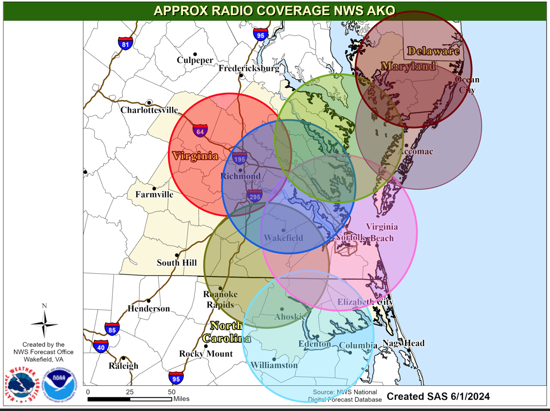
Range Rings on Map Not to Any Scale. See Transmitter Table below.
 |
Also please visit the National NOAA All Hazards Weather Radio special needs
page
FIPS Codes for Virginia, Maryland, DELMARVA, & MARINE
FIPS Codes for North Carolina
| Color Code |
Call Sign
|
Frequency
|
Locations Served
|
|
 |
KHB-37
|
162.550 MHz
|
Southeast VA & Northeast NC, including Tidewater area, Hampton Roads and Northeast Outer Banks
|
|
 |
WNG537
|
162.525 MHz
|
Northeast North Carolina including the
city of Windsor
|
|
 |
WXK-65
|
162.475 MHz
|
Piedmont Region including
the City of Richmond
|
|
 |
KAE42
|
162.500 MHz
|
New Kent /
Providence Forge
|
|
 |
WXM-57
|
162.400 MHz
|
Northern Neck and
Middle Peninsula
|
|
 |
WWG-33
|
162.450 MHZ
|
South Central Virginia South to the NC Border
including Northampton County NC
|
|
 |
KEC-92
|
162.475MHz
|
Delmarva Peninsula including
the city of Salisbury, MD
|
|
 |
KJY-99
|
162.525MHz
|
Lower Eastern Shore including the
cities of Exmore, Chincoteague, and Pocomoke
|
HAM RADIO FREQUENCIES USED FOR NOAA WEATHER RADIO
|
FRANKLIN, VA
|
147.30
|
ELIZABETH CITY, NC
|
146.655
|
|
RICHMOND, VA
|
145.430
|
WILLIAMSBURG, VA
|
146.76
|
|
CHESTER, VA
|
147.36
|
CHESAPEAKE, VA
|
145.330
|
|
AHOSKIE, NC
|
146.91
|
ISLE OF WIGHT, VA
|
147.195
|
We are here to serve you and provide you with the most current weather information available! For a listing of nationwide NOAA Weather Radio stations, click here
Recorded forecasts are also available by calling: (757) 899-4200.
The Emergency Alert System (EAS)
On January 1, 1997, EAS replaced the Emergency Broadcast System (EBS) as the coordinated means of relaying tornado, flash flood and nationwide non-weather related warnings to the public via the radio and TV broadcast media. Specific Area Message Encoding (SAME) allows NOAA Weather Radio (and therefore the NWS) to DIRECTLY interface with EAS. This digital interface means that, for radio and TV stations, and cable outlets, warnings for tornadoes, severe thunderstorms, flash floods, winter storms and hurricanes can be broadcast over the air faster and without human intervention! For more information regarding EAS, visit the Virginia EAS Home Page . To view a map of EAS areas and their relation to the NOAA Weather Radio click here.
If you have further questions regarding EAS........click here.
For other NOAA Weather Radio Stations and frequencies, click here.


 Coastal Flood
 Heat
Heat