Overview
General Summary: Tropical Storm Elsa made landfall on the west coast of Florida during the morning of July 7 (Wednesday). Elsa then tracked north-northeastward through Georgia and the Carolinas from Wednesday through the first part of the day on Thursday, July 8. Elsa then tracked to the north-northeast across eastern Virginia and the Delmarva Peninsula as a low-end tropical storm from the evening of July 8th to the early morning on Friday, July 9th.
Some wind impacts (due to gusts of 40-50 mph, with a couple gusts as high as 60 mph) were felt across eastern VA, northeast NC, and the Lower Eastern Shore. Localized power outages occurred, but impacts were far less than what was observed during Isaias in August 2020, when 300,000 people were without power at one point. However, there were some significant flood/flash flood impacts (generally along and just to the left of the track). A swath of 2-5” of rain was observed from Mecklenburg/Lunenburg Counties to southern/eastern portions of the Richmond Metro to Dorchester County, Maryland. There was one report of just under 6" of rain in Chesterfield County, VA. The most significant flooding from Elsa in the AKQ CWA occurred Thursday evening when 70% of all roads in the City of Petersburg were closed at the height of the event (see the Flooding Reports section for a list of reports). This was in addition to several reports of flooding/flash flooding across the area. Five tornadoes (all EF-0) touched down across SE VA and NE NC. Minor tidal flooding was observed on the north side of the Albemarle Sound and on the bay side of the Lower Maryland Eastern Shore.
Tornadoes: As Elsa tracked to the NNE through the area late Thursday afternoon into Thursday evening, slightly drier air surged in from the west-southwest (see T-Td-Wind loop in environment section for more detail). This created a boundary between the moist air to the northeast and dry air surging in from the west-southwest. On the east side of the boundary, winds were mainly out of the SE with temperatures in the mid to upper 70s to and surface dew points in the mid 70s. To the west of the boundary, winds were generally out of the southwest with slightly lower dew points. As is typical with tropical storms, the boundary layer wind fields were relatively strong and the best low-level speed/directional shear was located to the right of the track of the system. Along and just east of the track, slightly veering (and increasing) winds from the surface to 925 mb allowed for 0-1 km SRH values to climb to higher levels (locally 200-350 m2/s2) in an area roughly to the east and northeast of the center of Elsa. This combined with modest instability (500-1000 J/kg to the E/NE of the center on average) resulted in an environment favorable for brief, spin-up tornadoes. Interestingly, around/just before 4 PM, there was one mini supercell that exhibited very strong rotation (reminiscent of the supercells that produced EF-2 tornadoes during Isaias in August 2020) that tracked northward across Bertie/Hertford/Gates Counties in NE NC. This supercell was well to the northeast of the boundary between the moist and slightly drier air and failed to produce more than a weak EF-0 tornado despite having a well-defined, deep mesocyclone with rotational velocity values of 40 to 45 knots. When a rain band just ahead of that slightly drier air at the surface (and likely on the leading edge of some drier air in the mid-levels) tracked across SE VA and NE NC from 7 to 9 PM, 4 additional EF-0 tornadoes touched down across the area (from embedded rotating cells along that band). However, none of the cells along that band contained a mesocyclone that was as strong and deep as the one that was observed in that mini supercell just around/before 4 PM. One other difference in the environment between 4 PM and 7-9 PM that was noted by forecasters that worked the event was that LCLs were a few hundred meters higher during the late afternoon than during the evening.
Tidal Flooding: The fast track of Elsa (and the fact that it was a low-end tropical storm as it crossed the area) greatly limited the impacts from tidal flooding. Minor tidal flooding was observed in areas along the north side of the Albemarle Sound (from Edenton to Elizabeth City) during the evening of July 8th due to the elevated SE to SSW winds. Minor flooding was also observed on the bay side of the Lower Maryland Eastern Shore during this time.
*All tornado data is preliminary and subject to change.
Tornadoes:
|
Tornado - Harrellsville, NC
Track Map 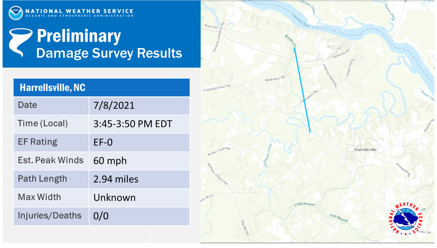 
|
||||||||||||||||
|
Tornado - SW of Suffolk, VA
Track Map 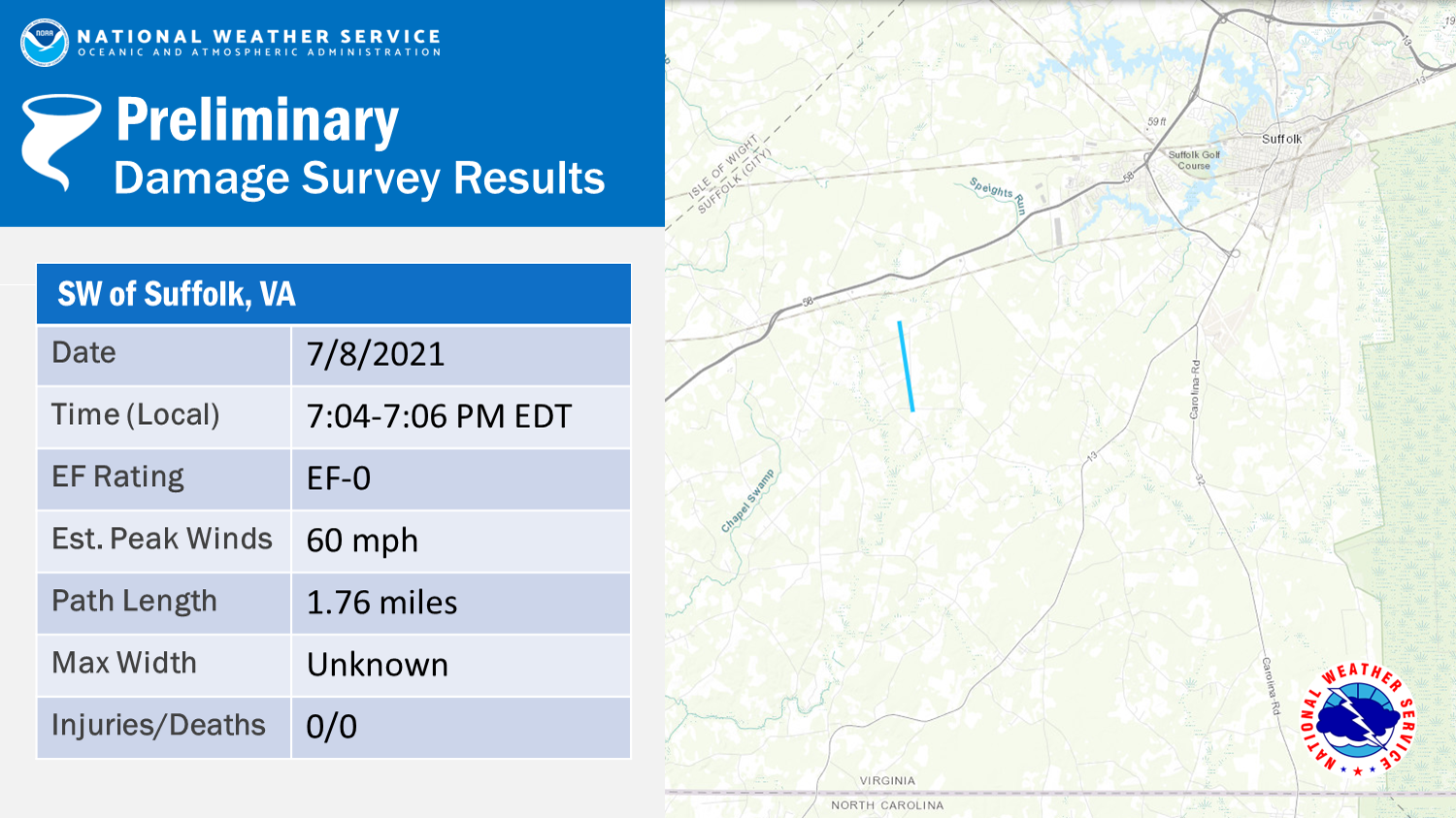
|
||||||||||||||||
|
Tornado - N of Downtown Suffolk, VA
Track Map 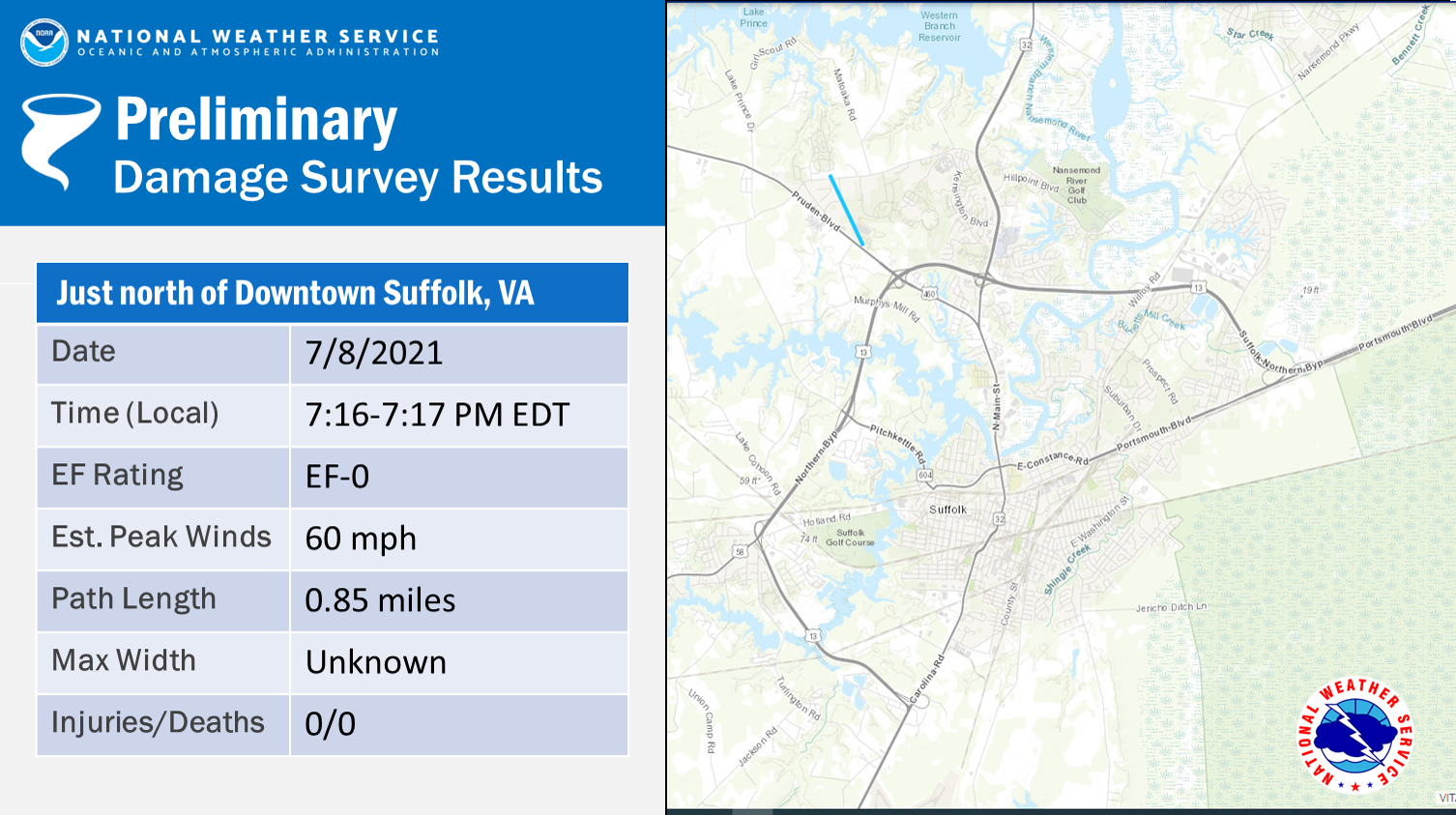
|
||||||||||||||||
|
Tornado - Smithfield, VA
Track Map 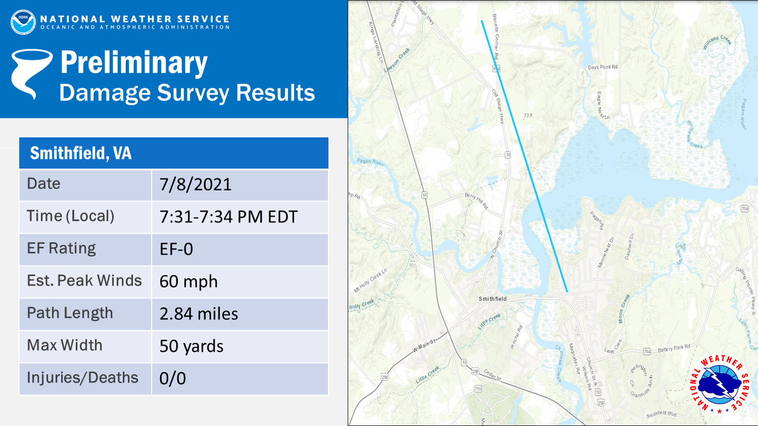
|
||||||||||||||||
|
Tornado - Taylors Beach, NC
Track Map 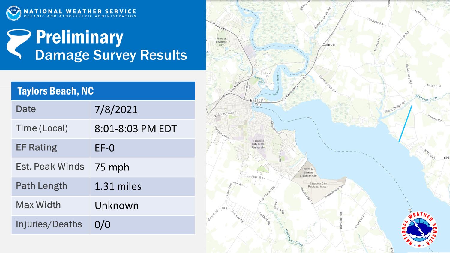
|
||||||||||||||||
The Enhanced Fujita (EF) Scale classifies tornadoes into the following categories:
| EF0 Weak 65-85 mph |
EF1 Moderate 86-110 mph |
EF2 Significant 111-135 mph |
EF3 Severe 136-165 mph |
EF4 Extreme 166-200 mph |
EF5 Catastrophic 200+ mph |
 |
|||||
Flooding Reports
..TIME...   ...EVENT...      ...CITY LOCATION...     ...LAT.LON...
..DATE...   ....MAG....      ..COUNTY LOCATION..ST.. ...SOURCE....
            ..REMARKS..
0630 PM     FLASH FLOOD      ARVINS STORE            37.03N 78.34W
07/08/2021                   LUNENBURG          VA   DEPT OF HIGHWAYS

            NUMEROUS ROADS CLOSED OR WASHED OUT DUE TO
            HIGH WATER ACROSS THE NW PART OF LUNENBURG
            COUNTY INCLUDING CRYMES RD, KINGS RD, FALLS
            RD, AND OTHERS. TIME ESTIMATED.
0845 PM     FLASH FLOOD      1 W PETERSBURG NATIONAL 37.23N 77.39W
07/08/2021                   CITY OF PETERSBURG VA   BROADCAST MEDIA

            NEARLY 70% OF ALL ROADS IN PETERSBURG CLOSED
            DUE TO FLOODING AT THE HEIGHT OF THE EVENT.
0810 PM     FLASH FLOOD      1 E CHESTER             37.35N 77.41W
07/08/2021                   CHESTERFIELD       VA   911 CALL CENTER

            REPORTS OF STRANDED VEHICLES IN HIGH WATER
            ON WEST HUNDRED RD AND JEFF DAVIS HIGHWAY.
            ONE WATER RESCUE PERFORMED.
0815 PM     FLASH FLOOD      3 WSW CHESTER           37.34N 77.48W
07/08/2021                   CHESTERFIELD       VA   911 CALL CENTER

            CAR STRANDED DUE TO HIGH WATER.
0845 PM     FLASH FLOOD      BELLWOOD                37.41N 77.44W
07/08/2021                   CHESTERFIELD       VA   DEPT OF HIGHWAYS

            CHESTER RD AT PERRYMONT RD CLOSED DUE TO
            HIGH WATER.
0845 PM     FLASH FLOOD      1 SW NEW BOHEMIA        37.18N 77.33W
07/08/2021                   PRINCE GEORGE      VA   NWS EMPLOYEE

            WATER OVER RIVES ROAD.
0845 PM     FLASH FLOOD      2 ENE CHESTER           37.37N 77.40W
07/08/2021                   CHESTERFIELD       VA   DEPT OF HIGHWAYS

            OSBORNE RD AT OLD STAGE RD CLOSED DUE TO
            HIGH WATER.
0900 PM     FLASH FLOOD      3 N COLONIAL HEIGHTS    37.31N 77.40W
07/08/2021                   CHESTERFIELD       VA   NWS EMPLOYEE

            WATER COVERING INTERSECTION OF WOODS EDGE
            AND RUFFIN MILL ROAD.
0925 PM     FLASH FLOOD      3 WNW ADKINS STORE      37.40N 77.14W
07/08/2021                   CHARLES CITY       VA   DEPT OF HIGHWAYS

            CATTAIL RD AT BARNETTS RD CLOSED DUE TO HIGH
            WATER.
0911 PM     FLASH FLOOD      2 SE MATOACA            37.21N 77.46W
07/08/2021                   DINWIDDIE          VA   DEPT OF HIGHWAYS

            BOYDTON PLANK RD AT FRANKLIN ST CLOSED DUE
            TO HIGH WATER.
Post Tropical Cyclone Report (PSH)
POST TROPICAL CYCLONE REPORT...HURRICANE ELSA
NATIONAL WEATHER SERVICE WAKEFIELD VA
256 PM EDT TUE JUL 13 2021
NOTE: THE DATA SHOWN HERE ARE PRELIMINARY....AND SUBJECT TO UPDATES
AND CORRECTIONS AS APPROPRIATE.
THIS REPORT INCLUDES EVENTS OCCURRING WHEN WATCHES AND/OR WARNINGS
WERE IN EFFECT...OR WHEN SIGNIFICANT FLOODING ASSOCIATED WITH ELSA
OR ITS REMNANTS WAS AFFECTING THE AREA.
COUNTIES INCLUDED...ACCOMACK ...AMELIA ...BERTIE ...BRUNSWICK ...
CAMDEN ...CAROLINE ...CHARLES CITY ...CHESAPEAKE...CHESTERFIELD ...
CHOWAN ...COLONIAL HEIGHTS...CUMBERLAND ...CURRITUCK ...DINWIDDIE...
DORCHESTER ...EMPORIA...ESSEX ...FLUVANNA...FRANKLIN...FRANKLIN ...
GATES ...GLOUCESTER ...GOOCHLAND ...GREENSVILLE ...HAMPTON ...
HANOVER ...HENRICO...HERTFORD ...HOPEWELL...ISLE OF WIGHT ...
JAMES CITY COUNTY...KING AND QUEEN ...KING WILLIAM ...LANCASTER ...
LOUISA ...LUNENBURG ...MATHEWS ...MECKLENBURG ...MIDDLESEX ...
NEW KENT ...NEWPORT NEWS...NORFOLK...NORTHAMPTON ...NORTHAMPTON ...
NORTHUMBERLAND ...NOTTOWAY ...PASQUOTANK ...PERQUIMANS ...
PETERSBURG...POQUOSON...PORTSMOUTH...POWHATAN...PRINCE EDWARD ...
PRINCE GEORGE ...RICHMOND CITY...RICHMOND COUNTY...SOMERSET ...
SOUTHAMPTON ...SUFFOLK ...SURRY ...SUSSEX ...VIRGINIA BEACH ...
WESTMORELAND ...WICOMICO ...WILLIAMSBURG...WORCESTER ...YORK
A. LOWEST SEA LEVEL PRESSURE/MAXIMUM SUSTAINED WINDS AND PEAK GUSTS
---------------------------------------------------------------------
METAR OBSERVATIONS...
NOTE: ANEMOMETER HEIGHT IS 10 METERS AND WIND AVERAGING IS 2 MINUTES
---------------------------------------------------------------------
LOCATION ID MIN DATE/ MAX DATE/ PEAK DATE/
LAT LON PRES TIME SUST TIME GUST TIME
DEG DECIMAL (MB) (UTC) (KT) (UTC) (KT) (UTC)
---------------------------------------------------------------------
KORF-NORFOLK INTL AIRPORT
36.91 -76.20 1005.6 09/0251 210/025 09/0251 190/038 09/0127
KECG-ELIZABETH CITY USCG
36.26 -76.17 1008.0 09/0054 200/027 09/0154 230/038 09/0236
KPHF-NEWPORT NEWS/PATRICK HENRY
37.14 -76.50 1004.1 09/0254 210/022 09/0250 260/035 09/0314
KWAL-WALLOPS ISLAND
37.97 -75.47 1002.9 09/0454 140/032 09/0308 110/045 09/0248
KOXB-OCEAN CITY AIRPORT
38.31 -75.12 1002.2 09/0553 130/034 09/0407 140/053 09/0407
KNTU-NAS OCEANA
36.83 -76.03 1006.5 09/0256 200/023 09/0221 220/035 09/0318
KMFV-ACCOMACK AIRPORT
37.65 -75.77 270/020 09/0615 160/030 09/0255
KRIC-RICHMOND INTL AIRPORT
37.51 -77.31 1006.5 09/0054 330/018 09/0154 330/026 09/0225
KCGE-CAMBRIDGE AIRPORT
38.54 -76.03 310/018 09/0655 320/026 09/0755
KJGG-JAMES CITY/WILLIAMSBURG AIRPORT
37.24 -76.72 280/021 09/0435 150/035 09/0015
KPTB-PETERSBURG/DINWIDDIE AIRPORT
37.19 -77.52 1002.5 09/0035 010/023 09/0015 040/035 09/0035
REMARKS:
NON-METAR OBSERVATIONS...
NOTE: ANEMOMETER HEIGHT IN METERS AND WIND AVERAGING PERIOD IN
MINUTES INDICATED UNDER MAXIMUM SUSTAINED WIND IF KNOWN
---------------------------------------------------------------------
LOCATION ID MIN DATE/ MAX DATE/ PEAK DATE/
LAT LON PRES TIME SUST TIME GUST TIME
DEG DECIMAL (MB) (UTC) (KT) (UTC) (KT) (UTC)
---------------------------------------------------------------------
ASTM2-ASSATEAGUE ISLAND VA
38.08 -75.20 999.7 09/0540 120/031 09/0340 180/055 09/0440
20
ELRM7-ELIZABETH CITY BLM NC
36.47 -76.28 230/021 09/0213 230/043 09/0213
20
BBYV2-BACK BAY VA
36.67 -75.92 230/026 09/0254 230/045 09/0345
20
B. MARINE OBSERVATIONS...
NOTE: ANEMOMETER HEIGHT IN METERS AND WIND AVERAGING PERIOD IN
MINUTES INDICATED UNDER MAXIMUM SUSTAINED WIND IF KNOWN
---------------------------------------------------------------------
LOCATION ID MIN DATE/ MAX DATE/ PEAK DATE/
LAT LON PRES TIME SUST TIME GUST TIME
DEG DECIMAL (MB) (UTC) (KT) (UTC) (KT) (UTC)
---------------------------------------------------------------------
CHYV2-CAPE HENRY VA
36.91 -75.78 1006.0 09/0242 150/028 09/0048 150/038 09/0048
27.9
KPTV2-KIPTOPEKE VA
37.17 -75.98 160/032 09/0106 160/044 09/0106
7.2
DOMV2-DOMINION TERMINAL VA
36.96 -76.42 1005.0 09/0224 130/033 08/2336 150/044 09/2348
8.8
MNPV2-MONEY POINT VA
36.78 -76.30 1005.8 09/0048 150/022 08/2324 150/030 08/2342
5.8
RPLV2-RAPPAHANNOCK LIGHT TOWER VA
37.54 -76.02 1003.5 09/0406 130/042 09/0130 130/050 09/0130
16.9
YRKV2-YORK RIVER RANGE LIGHT VA
37.25 -76.33 130/042 08/2354 130/051 08/2354
16.8
YKTV2-YORKTOWN USCG STATION
37.23 -76.48 1002.8 09/0242 260/030 09/0318 270/039 09/0442
9.6
LWTV2-LEWISETTA VA
38.00 -76.47 1003.9 09/0400 110/029 09/0030 120/035 09/0042
6.4
BISM2-BISHOPS HEAD MD
38.22 -76.04 1002.9 09/0454 310/027 09/0724 310/034 09/0730
7.1
CAMM2-CAMBRIDGE MD
38.57 -76.06 1004.3 09/0448 060/028 09/0424 070/034 09/0430
6.4
WAHV2-WACHAPREAGUE VA
37.61 -75.69 1002.8 09/0418 140/028 09/0118 140/037 09/0118
7.0
CRYV2-SOUTH CRANEY ISLAND VA
36.89 -76.34 1005.4 09/0206 130/032 08/2348 130/040 08/2348
8.6
OCEAN CITY INLET MD
38.32 -75.09 1003.1 09/0554 140/022 09/0406 140/035 09/0406
8.5
WILLOUGHBY DEGAUSSING STATION VA
36.96 -76.33 1004.0 09/0306 250/037 09/0406 250/043 09/0400
12.2
STINGRAY POINT (CBIBS) VA
37.55 -76.25 1002.3 09/0630 120/031 09/0030 120/045 09/0012
3.0
CHBV2-CHESAPEAKE BAY BRIDGE TUNNEL VA
37.03 -76.08 1004.2 09/0306 260/034 09/0542 170/047 09/0042
4.6
TANGIER ISLAND VA (WEATHERFLOW)
37.78 -75.98 140/050 09/0153 140/059 09/0155
52
POQUOSON VA (WEATHERFLOW)
37.11 -76.31 250/039 09/0332 250/048 09/0343
34
ASSATEAGUE ISLAND MD (WEATHERFLOW)
38.21 -75.20 140/046 09/0353 140/059 09/0355
13
PLANTATION FLATS/CAPE CHARLES VA (WEATHERFLOW)
37.26 -76.03 150/044 09/0110 140/061 09/0056
43
NEW POINT COMFORT VA (WEATHERFLOW)
37.33 -76.27 140/043 08/2359 140/048 09/0019
42
3RD ISLAND CHESAPEAKE BAY BRIDGE TUNNEL VA (WEATHERFLOW)
37.03 -76.08 260/042 09/0512 260/060 09/0517
52
SANDBRIDGE VA (WEATHERFLOW)
36.71 -75.93 190/041 09/0216 200/059 09/0240
15
THIMBLE SHOALS/CHESAPEAKE BAY VA (WEATHERFLOW)
37.05 -76.26 100/040 08/2346 220/045 09/0323
20
HAMPTON FLATS/HAMPTON VA (WEATHERFLOW)
36.98 -76.34 290/039 09/0404 290/047 09/0404
23
CRISFIELD MD (WEATHERFLOW)
37.97 -75.88 320/039 09/0616 320/045 09/0616
21
ONANCOCK VA (WEATHERFLOW)
37.66 -75.87 260/039 09/0533 250/052 09/0534
46
OCEAN CITY MD (WEATHERFLOW)
38.33 -75.08 130/039 09/0407 120/044 09/0406
34
LAFAYETTE RIVER/NORFOLK VA (WEATHERFLOW)
36.89 -76.32 220/036 09/0304 140/045 08/2329
20
CAPE HENRY VA (WEATHERFLOW)
36.92 -76.01 150/036 08/2214 190/044 09/0231
75
LYNNHAVEN PIER/VIRGINIA BEACH VA (WEATHERFLOW)
36.92 -76.08 120/035 08/2318 130/043 08/2335
26
SILVER BEACH VA (WEATHERFLOW)
37.49 -75.97 200/034 08/1727 140/043 09/0132
25
RACCOON POINT MD (WEATHERFLOW)
38.14 -75.79 210/034 08/1831 210/040 08/1834
20
DELTAVILLE VA (WEATHERFLOW)
37.56 -76.30 250/024 09/0524 260/033 09/0527
20
MIDDLE GROUND LIGHTHOUSE (WEATHERFLOW)
36.94 -76.39 130/048 08/2339 130/053 08/2333
65
POQUOSON RIVER LIGHT (WEATHERFLOW)
37.16 -76.38 140/047 09/0010 130/057 09/0010
22
JORDAN BRIDGE/S NORFOLK (WEATHERFLOW)
36.81 -76.29 190/042 09/0109 150/049 08/2318
192
WACHAPREAGUE (WEATHERFLOW)
37.60 -75.69 140/041 09/0203 130/053 09/0122
34
RUDEE INLET (WEATHERFLOW)
36.83 -75.97 150/040 09/0030 160/045 09/0028
29
LOWER HOOPER ISLAND (WEATHERFLOW)
38.26 -76.18 120/034 09/0124 110/038 09/0119
28
CREEDS (WEATHERFLOW)
36.59 -76.02 220/022 09/0125 160/036 08/2309
34
REMARKS:
C. STORM TOTAL RAINFALL FROM 0000 UTC JUL 9 UNTIL 0000 UTC JUL 9
---------------------------------------------------------------------
CITY/TOWN COUNTY ID RAINFALL
LAT LON (IN)
DEG DECIMAL
---------------------------------------------------------------------
4 SW CHESTER CHESTERFIELD 5.57
37.32 -77.49
1 NNE PETERSBURG AIRPOR DINWIDDIE 4.66
37.17 -77.52
4 N MATOACA CHESTERFIELD 4.65
37.29 -77.48
1 NE GARYSVILLE PRINCE GEORGE 4.60
37.26 -77.14
3 ESE BIRCHETT ESTATE PRINCE GEORGE 4.46
37.24 -77.23
1 SSE MEADOWVILLE CHESTERFIELD 4.45
37.36 -77.32
1 SW RICHARDSON MECKLENBURG 4.34
36.55 -78.47
2 W HENRICO NORTHAMPTON 4.22
36.54 -77.86
2 ESE COLONIAL DOWNS NEW KENT 4.06
37.48 -77.00
1 NE HOPEWELL CITY OF HOPEWELL 3.97
37.30 -77.29
4 S GARYSVILLE PRINCE GEORGE 3.95
37.19 -77.15
1 SSE BLACKSTONE AIRPOR NOTTOWAY 3.86
37.07 -77.95
1 S BLACKSTONE NOTTOWAY 3.85
37.07 -78.00
1 SSE HENRICO NORTHAMPTON 3.82
36.53 -77.83
3 SE GLENDALE CHARLES CITY 3.79
37.42 -77.20
1 ESE BOYDTON MECKLENBURG 3.75
36.66 -78.37
2 SSE BURKEVILLE NOTTOWAY 3.70
37.16 -78.19
CLAREMONT SURRY 3.65
37.23 -76.97
2 ESE DISPUTANTA PRINCE GEORGE 3.62
37.11 -77.20
COLONIAL HEIGHTS CITY OF COLONIAL H 3.57
37.27 -77.39
NEW KENT AIRPORT NEW KENT 3.54
37.50 -77.12
1 N VICTORIA LUNENBURG 3.53
37.01 -78.22
1 SW SMITH POINT NORTHUMBERLAND 3.42
37.88 -76.25
1 ESE MOLLUSK LANCASTER 3.40
37.72 -76.52
1 SW TOANO JAMES CITY 3.35
37.37 -76.81
1 WNW CAMBRIDGE DORCHESTER 3.34
38.57 -76.10
1 SSE HEALYS MIDDLESEX 3.32
37.56 -76.51
1 N REMLIK MIDDLESEX 3.28
37.68 -76.62
3 WSW GARYSVILLE PRINCE GEORGE 3.20
37.23 -77.20
1 ENE TOANO JAMES CITY 3.12
37.39 -76.78
2 E CREWE NOTTOWAY 3.11
37.18 -78.10
1 SSE MOLLUSK LANCASTER 3.11
37.71 -76.53
2 E HOWLAND NORTHUMBERLAND 3.07
37.87 -76.42
2 ENE MOLLUSK LANCASTER 3.06
37.73 -76.51
2 E HOWLAND NORTHUMBERLAND 3.05
37.87 -76.42
3 SE LINKWOOD DORCHESTER 3.05
38.51 -75.91
2 SE EAST NEW MARKET DORCHESTER 3.01
38.58 -75.90
3 ENE ROGERS CORNER MECKLENBURG 3.00
36.73 -78.36
2 SSE WALKERS DINWIDDIE 2.99
37.13 -77.69
2 NNE HARCUM MIDDLESEX 2.99
37.54 -76.50
EAST NEW MARKET DORCHESTER 2.96
38.60 -75.92
3 SW EBONY BRUNSWICK 2.93
36.55 -78.03
2 WSW WARREN MILL JAMES CITY 2.92
37.36 -76.87
1 WSW STAMPERS MIDDLESEX 2.91
37.54 -76.44
1 W PAMPA GLOUCESTER 2.90
37.53 -76.61
KILMARNOCK LANCASTER 2.89
37.71 -76.38
1 SW SMITH POINT NORTHUMBERLAND 2.87
37.88 -76.25
1 ESE LAKEWOOD WICOMICO 2.86
38.32 -75.57
PRINCESS ANNE SOMERSET 2.85
38.20 -75.69
2 NE WEST POINT KING AND QUEEN 2.81
37.57 -76.78
DELMAR WICOMICO 2.76
38.45 -75.57
1 NNE ELKO HENRICO 2.75
37.48 -77.21
PRINCE GEORGE PRINCE GEORGE 2.75
37.22 -77.29
2 E WHARFS STORE DINWIDDIE 2.73
36.98 -77.54
1 NW CAMBRIDGE DORCHESTER 2.72
38.58 -76.09
DELMAR WICOMICO 2.71
38.45 -75.57
2 WSW ROMANCOKE KING WILLIAM 2.69
37.57 -76.89
1 NNE SKIMINO YORK 2.67
37.36 -76.70
2 N HARCUM GLOUCESTER 2.66
37.54 -76.51
CLARKSVILLE MECKLENBURG 2.65
36.62 -78.57
2 WNW EDGERTON BRUNSWICK 2.64
36.78 -77.80
1 E COOPER MIDDLESEX 2.60
37.61 -76.49
1 ESE REMLIK MIDDLESEX 2.60
37.66 -76.60
1 S BRODNAX BRUNSWICK 2.59
36.68 -78.03
SKIMINO YORK 2.59
37.35 -76.70
1 N COWIE CORNER GREENSVILLE 2.58
36.79 -77.57
2 NNE ORAL OAKS LUNENBURG 2.57
36.95 -78.18
1 E CRISFIELD SOMERSET 2.56
37.98 -75.84
3 SSW PITTSVILLE WICOMICO 2.55
38.36 -75.43
2 NNE LOTTSBURG NORTHUMBERLAND 2.49
37.99 -76.51
2 ENE EAST NEW MARKET DORCHESTER 2.48
38.61 -75.89
1 E BYRDTON NORTHUMBERLAND 2.48
37.70 -76.31
2 S DELTAVILLE MIDDLESEX 2.47
37.53 -76.33
2 SSW BERLIN SOUTHAMPTON 2.45
36.83 -76.99
YORK RIVER STATE PARK JAMES CITY 2.43
37.41 -76.71
LAKEWOOD WICOMICO 2.41
38.33 -75.59
3 WSW BUCKTOWN DORCHESTER 2.39
38.45 -76.09
DEAL ISLAND SOMERSET 2.38
38.15 -75.95
2 SW DREWRYVILLE SOUTHAMPTON 2.36
36.69 -77.34
3 WSW KENBRIDGE LUNENBURG 2.36
36.95 -78.17
2 NE ARK GLOUCESTER 2.33
37.46 -76.54
1 NNW WAKEFIELD SUSSEX 2.33
36.98 -77.00
2 N FIVE FORKS JAMES CITY 2.32
37.28 -76.76
2 NW WAKEFIELD SUSSEX 2.30
36.98 -77.01
1 SE CENTERVILLE JAMES CITY 2.30
37.31 -76.78
WAKEFIELD SUSSEX 2.26
36.97 -76.99
DUTTON GLOUCESTER 2.24
37.50 -76.47
2 W PARSONSBURG WICOMICO 2.24
38.39 -75.50
2 SSW EWELL JAMES CITY 2.24
37.30 -76.75
2 SSW EWELL JAMES CITY 2.21
37.30 -76.75
2 WSW PRINCESS ANNE SOMERSET 2.20
38.19 -75.73
1 WNW FIVE FORKS JAMES CITY 2.20
37.26 -76.79
2 N FIVE FORKS JAMES CITY 2.19
37.28 -76.77
5 SSW MIDLOTHIAN CHESTERFIELD 2.18
37.44 -77.67
6 N OCEAN CITY WORCESTER 2.18
38.44 -75.06
2 SSW PRINCESS ANNE SOMERSET 2.18
38.17 -75.71
EWELL JAMES CITY 2.18
37.33 -76.75
HUNTERDALE CITY OF FRANKLIN 2.17
36.70 -76.95
2 NE GOVERNORS LAND JAMES CITY 2.17
37.27 -76.81
1 NW GLOUCESTER COURTHO GLOUCESTER 2.16
37.42 -76.53
2 WNW OPHEILA NORTHUMBERLAND 2.14
37.93 -76.32
1 N WEST POINT KING WILLIAM 2.13
37.57 -76.80
2 SSW EWELL JAMES CITY 2.10
37.30 -76.75
1 NNW SELDEN GLOUCESTER 2.10
37.37 -76.47
2 N FIVE FORKS JAMES CITY 2.09
37.27 -76.76
SNOW HILL WORCESTER 2.05
38.17 -75.39
EMPORIA AIRPORT GREENSVILLE 2.03
36.68 -77.48
2 ENE HARMONY VILLAGE MIDDLESEX 2.01
37.60 -76.45
2 N WILLIAMSBURG YORK 2.00
37.30 -76.70
1 NNW GLOUCESTER COURTH GLOUCESTER 1.99
37.42 -76.53
3 NW BEACH CHESTERFIELD 1.97
37.38 -77.64
1 N VARINA HENRICO 1.97
37.46 -77.35
1 NE FIVE FORKS JAMES CITY 1.97
37.26 -76.75
1 NE GREENBACKVILLE ACCOMACK 1.96
38.01 -75.40
1 NW WILLIAMSBURG AIRPO JAMES CITY 1.96
37.25 -76.73
1 N WILLIAMSBURG AIRPOR CITY OF WILLIAMSBU 1.95
37.25 -76.72
1 NE MARDELA SPRINGS WICOMICO 1.94
38.47 -75.75
1 N RICHMOND INTERNATIO HENRICO 1.94
37.52 -77.32
1 ESE HAYES GLOUCESTER 1.90
37.37 -76.49
1 ENE WILLIAMSBURG CITY OF WILLIAMSBU 1.87
37.28 -76.68
2 WNW KINGS FORK CITY OF SUFFOLK 1.86
36.79 -76.66
1 S FIVE FORKS JAMES CITY 1.86
37.24 -76.77
1 N ALLMONDSVILLE GLOUCESTER 1.85
37.41 -76.65
1 SSW ACHILLES GLOUCESTER 1.85
37.26 -76.45
2 W FIVE FORKS JAMES CITY 1.85
37.25 -76.80
CONWAY NORTHAMPTON 1.83
36.43 -77.23
DARE YORK 1.83
37.17 -76.44
2 E CLAY BANK GLOUCESTER 1.80
37.37 -76.55
1 W YORK TERRACE JAMES CITY 1.80
37.27 -76.68
1 W HUNTERDALE SOUTHAMPTON 1.79
36.70 -76.98
2 WNW KILBY CITY OF SUFFOLK 1.79
36.74 -76.66
2 N SNUG HARBOR PERQUIMANS 1.78
36.11 -76.43
3 E MOSELEY CHESTERFIELD 1.78
37.42 -77.71
BEACONSDALE CITY OF NEWPORT NE 1.78
37.06 -76.47
1 S FORT NONSENSE MATHEWS 1.77
37.45 -76.45
2 NNW CHESTERFIELD CHESTERFIELD 1.77
37.40 -77.52
2 ESE SPANISH GROVE MECKLENBURG 1.76
36.78 -78.50
1 ENE CARDINAL MATHEWS 1.76
37.43 -76.36
2 NNE BEACONSDALE CITY OF NEWPORT NE 1.76
37.09 -76.46
3 NW SHAD POINT WICOMICO 1.76
38.37 -75.66
1 WSW BOTTOMS BRIDGE HENRICO 1.75
37.51 -77.21
1 SW SMITHFIELD ISLE OF WIGHT 1.74
36.97 -76.63
1 N TABB YORK 1.73
37.14 -76.45
2 SSE MOONLIGHT ISLE OF WIGHT 1.72
37.01 -76.71
3 WSW BEACH CHESTERFIELD 1.71
37.34 -77.64
3 E BISHOPVILLE WORCESTER 1.69
38.45 -75.13
2 NNE DUNNSVILLE ESSEX 1.68
37.89 -76.81
1 N REMLIK MIDDLESEX 1.68
37.68 -76.62
SOUTH MILLS CAMDEN 1.68
36.44 -76.33
2 WNW WHITE MARSH GLOUCESTER 1.65
37.35 -76.55
4 ENE MOSELEY CHESTERFIELD 1.65
37.44 -77.70
2 SW SAINT JOHNS CHOWAN 1.65
36.02 -76.55
WINDSOR ISLE OF WIGHT 1.65
36.81 -76.73
3 SSW MIDLOTHIAN CHESTERFIELD 1.64
37.46 -77.66
PATRICK HENRY FIEL CITY OF NEWPORT NE 1.64
37.13 -76.50
1 SE PORT HAYWOOD MATHEWS 1.64
37.37 -76.31
BEACONSDALE CITY OF NEWPORT NE 1.63
37.06 -76.47
1 SE DOWNTOWN RICHMOND CITY OF RICHMOND 1.62
37.52 -77.46
TASLEY ACCOMACK 1.62
37.71 -75.71
1 NW LEE HALL CITY OF NEWPORT NE 1.61
37.20 -76.58
3 NE HIGHLAND SPRINGS HANOVER 1.60
37.58 -77.30
WILLIAMSBURG CITY OF WILLIAMSBU 1.60
37.28 -76.71
2 WSW COURTLAND SOUTHAMPTON 1.59
36.70 -77.10
1 SSW FORT A.P. HILL CAROLINE 1.59
38.10 -77.27
4 S MIDLOTHIAN CHESTERFIELD 1.59
37.44 -77.64
2 SSW DUMBARTON CITY OF RICHMOND 1.59
37.58 -77.52
1 WSW HOBSON CITY OF SUFFOLK 1.59
36.89 -76.53
1 ESE CAPE COLONY CHOWAN 1.58
36.02 -76.57
2 SSE CLAY BANK GLOUCESTER 1.58
37.33 -76.57
GLOUCESTER POINT GLOUCESTER 1.58
37.27 -76.50
1 WNW LIGHTFOOT JAMES CITY 1.58
37.35 -76.77
1 S GLOUCESTER POINT GLOUCESTER 1.57
37.26 -76.50
1 NE SMITHFIELD ISLE OF WIGHT 1.57
36.99 -76.61
3 S PORT ROYAL CAROLINE 1.56
38.13 -77.18
1 S NEWPORT NEWS CITY OF NEWPORT NE 1.56
37.06 -76.51
1 SSE ACHILLES GLOUCESTER 1.51
37.27 -76.43
2 ENE ROSLYN HILLS HENRICO 1.51
37.59 -77.54
1 W MAGNOLIA CITY OF SUFFOLK 1.51
36.74 -76.57
1 WNW HALLWOOD CITY OF HAMPTON 1.50
37.07 -76.32
1 NNE TUCKAHOE HENRICO 1.48
37.60 -77.58
2 ESE HOBSON CITY OF SUFFOLK 1.48
36.88 -76.48
2 N DOWNTOWN RICHMOND CITY OF RICHMOND 1.46
37.56 -77.47
1 SSE MACONS CORNER CITY OF VIRGINIA B 1.44
36.78 -75.99
3 NW BIRDSNEST NORTHAMPTON 1.42
37.46 -75.92
1 W WARE NECK GLOUCESTER 1.42
37.40 -76.48
1 E DARE YORK 1.42
37.17 -76.42
1 S MARYUS GLOUCESTER 1.41
37.27 -76.41
2 NNW MACHIPONGO NORTHAMPTON 1.41
37.43 -75.92
STRATFORD HALL WESTMORELAND 1.41
38.15 -76.84
2 ESE CARROLLTON ISLE OF WIGHT 1.40
36.93 -76.53
3 S HORNTOWN ACCOMACK 1.39
37.93 -75.47
4 SSE SANDBRIDGE BEACH CITY OF VIRGINIA B 1.38
36.67 -75.92
2 WSW FENTRESS CITY OF CHESAPEAKE 1.38
36.69 -76.21
1 NE MURFREESBORO HERTFORD 1.38
36.45 -77.08
1 E BON AIR CHESTERFIELD 1.37
37.52 -77.56
1 SE CLAREMONT SURRY 1.37
37.22 -76.95
1 SSW GALLUPS CORNER CITY OF VIRGINIA B 1.36
36.78 -76.14
4 ENE EAGLETOWN HERTFORD 1.35
36.28 -77.17
3 NNW HOWERTONS ESSEX 1.35
37.87 -76.90
1 N LEES MILL ISLE OF WIGHT 1.34
36.70 -76.90
2 SSE SAUNDERS CITY OF SUFFOLK 1.33
36.61 -76.55
EDENTON CHOWAN 1.32
36.06 -76.60
1 WSW GLEN ALLEN HENRICO 1.32
37.66 -77.50
2 SE TABB YORK 1.32
37.11 -76.42
1 N SIGMA CITY OF VIRGINIA B 1.32
36.74 -75.99
1 E FRANKLIN CITY OF FRANKLIN 1.31
36.68 -76.92
2 NNE DOWNTOWN RICHMOND CITY OF RICHMOND 1.31
37.55 -77.47
3 SSW SOMERSET CHOWAN 1.28
36.02 -76.48
SUFFOLK AIRPORT CITY OF SUFFOLK 1.26
36.68 -76.60
1 SSW BACK BAY CITY OF VIRGINIA B 1.23
36.63 -76.04
3 W LANGLEY AFB CITY OF HAMPTON 1.23
37.09 -76.42
2 SSE TABB YORK 1.22
37.10 -76.44
1 NNE ROCKYHOCK CHOWAN 1.20
36.20 -76.69
3 SSW BURNT MILLS PASQUOTANK 1.18
36.35 -76.28
1 WNW POQUOSON CITY OF POQUOSON 1.18
37.14 -76.40
5 E MOSELEY CHESTERFIELD 1.18
37.41 -77.68
3 ENE WINDSOR BERTIE 1.17
36.02 -76.89
2 S CHAMBERLAYNE HENRICO 1.14
37.60 -77.43
1 NE OCEAN CITY MUNICIP WORCESTER 1.14
38.32 -75.12
1 NNE TUCKAHOE HENRICO 1.14
37.59 -77.58
7 SE PUBLIC LANDING WORCESTER 1.12
38.08 -75.20
2 E ROSLYN HILLS CITY OF RICHMOND 1.12
37.58 -77.52
1 NE OCEAN CITY MUNICIP WORCESTER 1.10
38.32 -75.12
2 SE NORVIEW CITY OF NORFOLK 1.09
36.87 -76.23
4 N SPARTA CAROLINE 1.08
38.04 -77.24
LANGLEY VIEW CITY OF HAMPTON 1.08
37.07 -76.37
CONWAY NORTHAMPTON 1.07
36.44 -77.24
1 SSW OCEAN PINES WORCESTER 1.05
38.37 -75.16
1 NNE COMET ISLE OF WIGHT 1.05
36.99 -76.74
SOUTH MILLS CAMDEN 1.05
36.44 -76.33
3 N MOUNT PLEASANT CITY OF VIRGINIA B 1.04
36.75 -76.13
1 WSW LAUREL HENRICO 1.02
37.63 -77.53
3 NNE SHORT PUMP HENRICO 1.00
37.69 -77.59
3 NW MOYOCK CURRITUCK 1.00
36.52 -76.18
D. INLAND FLOODING...
---------------------------------------------------------------------
CITY OF PETERSBURG...NEARLY 70% OF ALL ROADS IN PETERSBURG CLOSED
DUE TO FLOODING AT THE HEIGHT OF THE EVENT.
LUNENBURG...NUMEROUS ROADS CLOSED OR WASHED OUT DUE TO HIGH WATER
ACROSS THE NW PART OF LUNENBURG COUNTY INCLUDING CRYMES RD, KINGS
RD, FALLS RD, AND OTHERS. TIME ESTIMATED.
CHESTERFIELD...CAR STRANDED DUE TO HIGH WATER.
CHESTERFIELD...REPORTS OF STRANDED VEHICLES IN HIGH WATER ON WEST
HUNDRED RD AND JEFF DAVIS HIGHWAY. ONE WATER RESCUE PERFORMED.
---------------------------------------------------------------------
E. MAXIMUM OBSERVED WATER LEVEL (WL)...
---------------------------------------------------------------------
ID CITY/TOWN COUNTY STATE WL DATUM DATE/ SOURCE
OR LOCATION (FT) TIME
---------------------------------------------------------------------
BISM2 BISHOPS HEAD WORCESTER MD 1.41 MHHW 09/0548 NOS
38.2204 -76.0387
CRSM2 CRISFIELD SOMERSET MD 2.49 NAVD88 09/0648 USGS
37.9783 -75.8636
SAXV2 SAXIS ACCOMACK VA 2.59 NAVD88 09/0642 USGS
37.9254 -75.7236
EWPN7 EDENTON CHOWAN NC 1.88 NAVD88 08/2240 OTHER
36.0558 -76.6019
NSWV2 SILVER BEACH NORTHAMPTON VA 2.05 NAVD88 09/0312 USGS
37.4846 -75.9611
EMWN7 ELIZABETH CITY PASQUOTANK NC 1.87 NAVD88 08/2315 OTHER
36.2960 -76.2206
REMARKS:
F. TORNADOES...
---------------------------------------------------------------------
(DIST)CITY/TOWN COUNTY DATE/ EF SCALE
LAT LON (DEG DECIMAL) TIME(UTC) (IF KNOWN)
DESCRIPTION
---------------------------------------------------------------------
2 WNW HARRELLSVILLE HERTFORD 8/1947 EF0 I
36.31 -76.82
A WEAK EF0 TORNADO TRACKED NORTHEAST FROM HIGHWAY 45 ACROSS WICCACON
RD AND BAZEMORE RD. DAMAGE WAS LIMITED A FEW DOWN TREES, SNAPPED
BRANCHES AND TREES TOPPED OUT.
1 SE KINGS FORK CITY OF SUFFOLK 8/2316 EF0 I
36.78 -76.62
NUMEROUS LIMBS SNAPPED AND TREE TOPS TORN OUT. OUTBUILDINGS AT
TRACTOR SUPPLY OVERTURNED.
SMITHFIELD ISLE OF WIGHT 8/2332 EF0 I
36.98 -76.62
TREES DOWN WITH ONE ON A HOME STRETCHING FROM JORDAN RD, ACROSS THE
PAGAN RIVER TO BLOUNTS CORNER RD.
TAYLORS BEACH CAMDEN 09/0002 EF0 I
36.28 -76.12
A BRIEF TORNADO DEVELOPED AS THE STORMS CROSSED THE RIVER AND THE
TORNADO MOVED ASHORE NEAR SUNSET AVENUE AND TRACKED NORTHEAST ABOUT
1.3 MILES TO NEAR ARENEUSE CREEK AND NC ROUTE 343. THE STORM SNAPPED
NUMEROUS TREES, RIPPED THE ROOF OFF OF A BOAT HOUSE ON THE RIVER AND
DESTROYED AN OUTBUILDING WHEN A LARGE PINE TREE FELL ON IT.
3 SSW LUMMIS CITY OF SUFFOLK 08/2304 EF0 I
36.66 -76.72
A WEAK EF0 SNAPPED A FEW TREES AND TORE LIMBS OUT OF TREES FROM NEAR
QUAKER RD AND LUMMIS ROAD TO NEAR QUINCE RD.
G. STORM IMPACTS BY COUNTY...
---------------------------------------------------------------------
COUNTY DEATHS INJURIES EVACUATIONS
DESCRIPTION
---------------------------------------------------------------------
$$
LEGEND:
I-INCOMPLETE DATA
E-ESTIMATED
DUTTER
Photos
To be added soon...
| Caption (source) |
Caption (source) |
Caption (source) |
Caption (source) |
Radar
Selected Radar Loops
 |
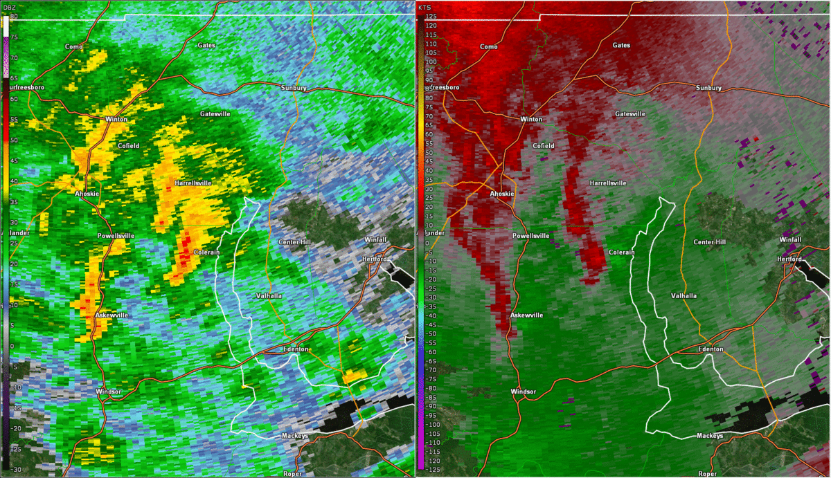 |
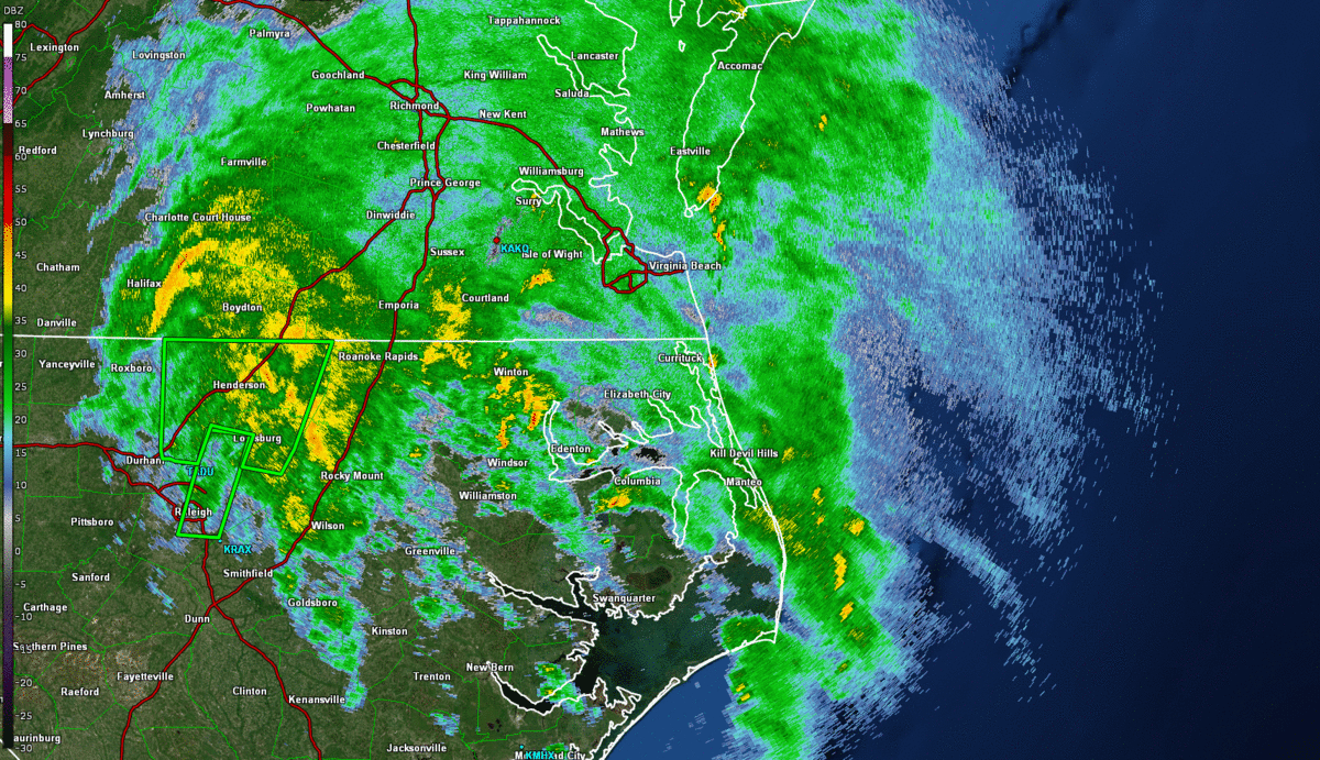
| Regional Radar Loop of 0.5° Reflectivity from ~3:30 to ~9:00 PM in ~30 minute increments. The green boxes represent Flash Flood Warnings that were issued during the event. | Radar Loop of 0.5° Reflectivity (left) and Storm Relative Velocity (right) of the initial mini supercell that tracked northward through Bertie, Hertford, and Gates Counties. Despite the strong mesocyclone, this cell only produced a weak EF-0 tornado. |
Wind Reports
...HIGHEST WIND REPORTS...

Location                     Speed     Time/Date       Lat/Lon

...Maryland...

...Dorchester County...
Cambridge, MD                39 MPH    1230 AM 07/09   38.57N/76.07W

...Worcester County...
Ocean City                   61 MPH    1207 AM 07/09   38.32N/75.12W
Assateague Island            55 MPH    1240 AM 07/09   38.08N/75.20W

...North Carolina...

...Chowan County...
Edenton                      39 MPH    0835 PM 07/08   36.02N/76.57W

...Currituck County...
3.0 E Knotts Island (WEATHER 52 MPH    1040 PM 07/08   36.52N/75.87W
Corolla                      45 MPH    0815 PM 07/08   36.30N/75.80W
0.5 E Jarvisburg (WEATHERSTE 45 MPH    0920 PM 07/08   36.20N/75.86W

...Northampton County...
Conway                       47 MPH    0610 PM 07/08   36.43N/77.23W

...Pasquotank County...
Elizabeth City Airport       44 MPH    1036 PM 07/08   36.27N/76.18W
Elizabeth City               43 MPH    1013 PM 07/08   36.35N/76.28W

...Perquimans County...
Hertford                     43 MPH    1000 PM 07/08   36.16N/76.32W
Chapanoke                    43 MPH    1015 PM 07/08   36.24N/76.36W

...Virginia...

...Accomack County...
Tangier Sound Light          59 MPH    0955 PM 07/08   37.79N/75.97W
Wachapreague                 53 MPH    0925 PM 07/08   37.60N/75.69W
Wallops Island               52 MPH    1048 PM 07/08   37.93N/75.47W
Onancock                     52 MPH    0134 AM 07/09   37.65N/75.88W
Parksley                     43 MPH    1045 PM 07/08   37.73N/75.61W
Wachapreague, VA             42 MPH    0918 PM 07/08   37.61N/75.69W

...City of Hampton County...
Langley AFB Hamp             44 MPH    0803 PM 07/08   37.07N/76.37W

...City of Newport News County...
Newport News                 40 MPH    1114 PM 07/08   37.13N/76.50W

...City of Norfolk County...
Lafayette River              45 MPH    0729 PM 07/08   36.89N/76.32W
Norfolk Intl Airport         44 MPH    0927 PM 07/08   36.90N/76.20W
HRBT - South Island          43 MPH    1215 AM 07/09   36.98N/76.30W
Norfolk NAS Cham             40 MPH    1218 AM 07/09   36.92N/76.27W

...City of Poquoson County...
Poquoson                     48 MPH    1143 PM 07/08   37.11N/76.32W

...City of Portsmouth County...
South Norfolk Jordan Bridge  49 MPH    0721 PM 07/08   36.81N/76.29W

...City of Suffolk County...
Suffolk                      51 MPH    0715 PM 07/08   36.68N/76.60W

...City of Virginia Beach County...
Oceana NAS Souce             46 MPH    0709 PM 07/08   36.82N/76.02W
Back Bay                     45 MPH    1154 PM 07/08   36.67N/75.92W
Cape Henry                   44 MPH    1031 PM 07/08   36.93N/76.01W
Virginia Beach               39 MPH    1014 PM 07/08   36.77N/76.04W

...Mathews County...
New Point Comfort            48 MPH    0819 PM 07/08   37.33N/76.27W

...Middlesex County...
Stingray Point               43 MPH    0850 PM 07/08   37.55N/76.30W

...Northampton County...
Kiptopeke, VA                51 MPH    0906 PM 07/08   37.17N/75.99W

...Northumberland County...
Lewisetta, VA                40 MPH    0942 PM 07/08   38.00N/76.46W

...York County...
Seaford                      40 MPH    0800 PM 07/08   37.19N/76.43W

...Maryland...

...Maritime Stations...
Assateague South Point       59 MPH    1156 PM 07/08   38.21N/75.20W
Ocean City                   43 MPH    1208 AM 07/09   38.33N/75.08W
Ocean City Inlet             40 MPH    1206 AM 07/09   38.33N/75.09W

...Virginia...
Plantation Flats             60 MPH    0856 PM 07/08   37.26N/76.03W
Third Island                 60 MPH    0117 AM 07/09   37.04N/76.08W
Rappahannock Light           58 MPH    0930 PM 07/08   37.54N/76.02W
Sandbridge                   58 MPH    1044 PM 07/08   36.70N/75.93W
Poquoson River Light         57 MPH    0810 PM 07/08   37.16N/76.38W
Third Island                 53 MPH    0733 PM 07/08   36.95N/76.39W
8 NW Cape Henry              52 MPH    1218 AM 07/09   37.03N/76.08W
2 E Stingray Point           49 MPH    0830 PM 07/08   37.57N/76.26W
Hampton Flats                46 MPH    1202 AM 07/09   36.98N/76.36W
Thimble Shoals               45 MPH    1123 PM 07/08   37.05N/76.26W
Rudee Inlet                  45 MPH    0829 PM 07/08   36.83N/75.97W
Yorktown USCG Training Cente 44 MPH    1248 AM 07/09   37.23N/76.48W
Willoughby Deguassing Statio 44 MPH    0742 PM 07/08   36.98N/76.32W
Silver Beach                 43 MPH    0932 PM 07/08   37.49N/75.97W
Lynnhaven Inlet Light 1L     43 MPH    0735 PM 07/08   36.92N/76.09W
James River Bridge@Isle of W 42 MPH    0100 AM 07/09   37.00N/76.47W
&&
Rain Reports
...PRECIPITATION REPORTS...

Location                     Amount    Time/Date       Provider

...Maryland...

...Dorchester County...
Cambridge 1.4 WNW            3.34 in   0900 AM 07/09   COCORAHS
Vienna 5.0 WNW               3.05 in   0900 AM 07/09   COCORAHS
East New Market 1.9 SE       3.01 in   0400 AM 07/09   COCORAHS
East New Market 0.0 WNW      2.96 in   0700 AM 07/09   COCORAHS
Cambridge                    2.72 in   0430 AM 07/09   CWOP
Hurlock 1.9 SW               2.48 in   0600 AM 07/09   COCORAHS
Blackwater                   2.39 in   1055 AM 07/09   RAWS

...Somerset County...
Princess Anne                2.85 in   0437 AM 07/09   CWOP
Crisfield 0.9 ENE            2.56 in   0830 AM 07/09   COCORAHS
Deal Island 0.5 SSW          2.38 in   0700 AM 07/09   COCORAHS
Princess Anne 1.9 WSW        2.20 in   0700 AM 07/09   COCORAHS
Princess Anne 2.1 SSW        2.18 in   0700 AM 07/09   COCORAHS

...Wicomico County...
Salisbury 3.4 SSE            2.86 in   0700 AM 07/09   COCORAHS
Delmar 0.2 NE                2.76 in   0606 AM 07/09   COCORAHS
Delmar 0.3 ESE               2.71 in   0600 AM 07/09   COCORAHS
Powellville                  2.55 in   0348 AM 07/09   RAWS
Fruitland 1.8 ENE            2.41 in   0700 AM 07/09   COCORAHS
Parsonsburg 1.6 WNW          2.24 in   0700 AM 07/09   COCORAHS
Mardela Springs              1.94 in   0440 AM 07/09   AWS
Salisbury                    1.76 in   1148 AM 07/09   CWOP

...Worcester County...
Ocean City 4.6 NNW           2.18 in   0700 AM 07/09   COCORAHS
Snow Hill 0.4 S              2.05 in   0700 AM 07/09   COCORAHS
Bishopville 3.1 E            1.69 in   0500 AM 07/09   COCORAHS
Ocean City                   1.14 in   1120 AM 07/09   ASOS
Assateague Island            1.12 in   0340 AM 07/09   RAWS
Ocean Pines 1.2 SSW          1.05 in   0800 AM 07/09   COCORAHS
Ocean Pines 0.9 SSW          0.91 in   0700 AM 07/09   COCORAHS
Berlin 6.5 SSE               0.82 in   0800 AM 07/09   COCORAHS

...North Carolina...

...Bertie County...
Greens Cross                 1.17 in   0417 AM 07/09   RAWS

...Camden County...
South Mills 0.1 SW           1.68 in   0700 AM 07/09   COCORAHS
South Mills                  1.05 in   0330 AM 07/09   HADS

...Chowan County...
1.7 SW Saint Johns           1.65 in   0700 PM 07/08   COOP
Edenton                      1.58 in   0435 AM 07/09   AWOS
Edenton 0.5 NE               1.32 in   0700 AM 07/09   COCORAHS
1 NNE Rockyhock              1.20 in   0435 AM 07/09   AWS

...Currituck County...
3 SSE Northwest              1.00 in   0435 AM 07/09   AWS
Moyock 1.8 SSE               0.96 in   0600 AM 07/09   COCORAHS
Corolla 5.8 SSE              0.96 in   0620 AM 07/09   COCORAHS
Grandy 0.6 E                 0.96 in   0700 AM 07/09   COCORAHS

...Hertford County...
Murfreesboro 1 NE            1.38 in   0600 AM 07/09   COOP
Ahoskie Tri Coun             1.35 in   0435 AM 07/09   AWOS

...Northampton County...
Henrico                      4.22 in   0431 AM 07/09   CWOP
Henrico 0.4 S                3.82 in   0800 AM 07/09   COCORAHS
Conway                       1.83 in   0430 AM 07/09   CWOP
Conway 0.3 W                 1.07 in   0700 AM 07/09   COCORAHS

...Pasquotank County...
Elizabeth City               1.18 in   0313 AM 07/09   RAWS
Elizabeth City 5.1 SSE       0.95 in   0700 AM 07/09   COCORAHS
Elizabeth City 3.5 NNW       0.94 in   0600 AM 07/09   COCORAHS
Elizabeth City Airport       0.86 in   1054 AM 07/09   ASOS
Elizabeth City 1.8 SE        0.75 in   0800 AM 07/09   COCORAHS

...Perquimans County...
Hertford                     1.78 in   0430 AM 07/09   CWOP
Hertford 11.4 E              0.83 in   0700 AM 07/09   COCORAHS

...Virginia...

...Accomack County...
Greenbackville 0.4 WNW       1.96 in   0700 AM 07/09   COCORAHS
Tasley 0.5 SW                1.62 in   0830 AM 07/09   COCORAHS
Wallops Island               1.39 in   0354 AM 07/09   ASOS
Melfa Accomack               0.99 in   1115 AM 07/09   AWOS

...Amelia County...
Amelia Courthouse            0.25 in   1150 AM 07/09   AWS

...Brunswick County...
Ebony                        2.93 in   0436 AM 07/09   CWOP
Lawrenceville                2.64 in   0435 AM 07/09   AWOS
South Hill Meckl             2.59 in   0435 AM 07/09   AWOS

...Caroline County...
Faph_delos                   1.59 in   0433 AM 07/09   RAWS
Faph_eodtc                   1.56 in   0432 AM 07/09   RAWS
Faph_south 1                 1.08 in   0433 AM 07/09   RAWS
Hanover 3.0 N                0.72 in   0700 AM 07/09   COCORAHS
Bowling Green                0.63 in   1144 AM 07/09   AWS

...Charles City County...
Charles City County          3.79 in   1146 AM 07/09   CWOP

...Chesterfield County...
Chesterfield                 5.57 in   1146 AM 07/09   CWOP
Matoaca                      4.65 in   0435 AM 07/09   CWOP
Chester 6.6 E                4.45 in   0500 AM 07/09   COCORAHS
Midlothian 4.7 SSW           2.18 in   0700 AM 07/09   COCORAHS
Midlothian                   1.97 in   1146 AM 07/09   CWOP
Moseley                      1.78 in   0430 AM 07/09   CWOP
Richmond Chester             1.77 in   0356 AM 07/09   AWOS
Winterpock                   1.71 in   1145 AM 07/09   CWOP
Moseley 1.7 NNE              1.65 in   0700 AM 07/09   COCORAHS
Midlothian 3.5 SSW           1.64 in   0800 AM 07/09   COCORAHS
4 S Midlothian               1.59 in   0439 AM 07/09   AWS
Bon Air                      1.37 in   0435 AM 07/09   CWOP
5 NNE Winterpock             1.18 in   0440 AM 07/09   AWS

...City of Chesapeake County...
Chesapeake                   1.38 in   0430 AM 07/09   CWOP

...City of Colonial Heights County...
Colonial Heights 0.3 ENE     3.57 in   0727 AM 07/09   COCORAHS

...City of Franklin County...
Franklin                     2.17 in   0440 AM 07/09   CWOP
1.0 E Franklin               1.31 in   0415 AM 07/09   HADS

...City of Hampton County...
Hampton 1.9 NW               1.50 in   0600 AM 07/09   COCORAHS
Hampton                      1.23 in   0437 AM 07/09   CWOP
Langley AFB Hamp             1.08 in   0356 AM 07/09   AWOS
Hampton 3.4 W                0.93 in   1019 AM 07/09   COCORAHS

...City of Hopewell County...
1 NE Hopewell                3.97 in   0440 AM 07/09   AWS

...City of Newport News County...
Newport News 2.7 ESE         1.78 in   0600 AM 07/09   COCORAHS
Newport News                 1.76 in   0439 AM 07/09   CWOP
Newport News                 1.64 in   0354 AM 07/09   ASOS
Newport News 2.5 ESE         1.63 in   0705 AM 07/09   COCORAHS
Newport News 9.6 NNW         1.61 in   0500 AM 07/09   COCORAHS
Newport News 0.9 S           1.56 in   0700 AM 07/09   COCORAHS

...City of Norfolk County...
1.6 SE Norview               1.09 in   1159 PM 07/08   COOP
Norfolk 5.0 SSW              0.83 in   0700 AM 07/09   COCORAHS

...City of Poquoson County...
Poquoson                     1.18 in   0435 AM 07/09   CWOP

...City of Portsmouth County...
Portsmouth 4.1 SSE           0.74 in   0700 AM 07/09   COCORAHS

...City of Richmond County...
Richmond 1.1 SE              1.62 in   0830 AM 07/09   COCORAHS
Richmond 3.9 NW              1.59 in   0600 AM 07/09   COCORAHS
Richmond 2.3 N               1.46 in   0800 AM 07/09   COCORAHS
Richmond                     1.31 in   0435 AM 07/09   CWOP
2 SW Dumbarton               1.12 in   0440 AM 07/09   AWS

...City of Suffolk County...
Suffolk 6.3 N                1.86 in   0700 AM 07/09   COCORAHS
Suffolk 2.9 NNW              1.79 in   0700 AM 07/09   COCORAHS
Suffolk 13.9 NNE             1.59 in   0700 AM 07/09   COCORAHS
Suffolk 4.9 NE               1.51 in   0700 AM 07/09   COCORAHS
Suffolk                      1.48 in   0430 AM 07/09   CWOP
Gdr                          1.33 in   0354 AM 07/09   RAWS
Suffolk                      1.26 in   0435 AM 07/09   AWOS

...City of Virginia Beach County...
Virginia Beach 4.2 NE        1.44 in   0800 AM 07/09   COCORAHS
Back Bay                     1.38 in   0354 AM 07/09   RAWS
Virginia Beach               1.36 in   0435 AM 07/09   CWOP
Virginia Beach 3.2 E         1.32 in   0700 AM 07/09   COCORAHS
Creeds                       1.23 in   0406 AM 07/09   CWOP
McHenry                      1.04 in   0429 AM 07/09   CWOP
Virginia Beach 9.5 N         0.96 in   0800 AM 07/09   COCORAHS
Virginia Beach 2.5 NE        0.93 in   0700 AM 07/09   COCORAHS

...City of Williamsburg County...
Williamsburg 1.3 SSW         1.95 in   0600 AM 07/09   COCORAHS
Williamsburg 1.4 ENE         1.87 in   0700 AM 07/09   COCORAHS
Williamsburg                 1.60 in   0440 AM 07/09   AWS

...Cumberland County...
1.2 E Reeds  (RP)  (RP)      0.80 in   0800 AM 07/09   COOP
Farmville                    0.59 in   1135 AM 07/09   AWOS

...Dinwiddie County...
Petersburg                   4.66 in   0435 AM 07/09   AWOS
Churchroad                   2.99 in   0430 AM 07/09   CWOP
Dinwiddie                    2.73 in   0434 AM 07/09   CWOP

...Essex County...
Dunnsville                   1.68 in   0438 AM 07/09   CWOP
Tappahannock                 1.35 in   0435 AM 07/09   AWOS

...Fluvanna County...
Scottsville                  0.50 in   1145 AM 07/09   CWOP

...Gloucester County...
Urbanna 8.2 SSW              2.90 in   0700 AM 07/09   COCORAHS
Gloucester Courthouse 9.1 N  2.66 in   0700 AM 07/09   COCORAHS
Gloucester Courthouse 3.5 NN 2.33 in   0700 AM 07/09   COCORAHS
Gloucester Courthouse 7.1 NN 2.24 in   0800 AM 07/09   COCORAHS
Gloucester Courthouse 0.5 NW 2.16 in   0700 AM 07/09   COCORAHS
Zanoni 1.7 SSE               2.10 in   0800 AM 07/09   COCORAHS
Gloucester Courthouse 0.7 NN 1.99 in   0830 AM 07/09   COCORAHS
Gloucester Courthouse 3.3 SE 1.90 in   0730 AM 07/09   COCORAHS
Gloucester Point 2.4 E       1.85 in   0700 AM 07/09   COCORAHS
Gloucester Courthouse 6.6 W  1.85 in   0705 AM 07/09   COCORAHS
Gloucester Courthouse 3.3 SS 1.80 in   0800 AM 07/09   COCORAHS
Gloucester Courthouse 4.2 SS 1.65 in   0800 AM 07/09   COCORAHS
Gloucester Point 0.3 WNW     1.58 in   0630 AM 07/09   COCORAHS
Gloucester Courthouse 5.8 SS 1.58 in   0800 AM 07/09   COCORAHS
Gloucester Point 0.6 S       1.57 in   0700 AM 07/09   COCORAHS
Hayes                        1.51 in   1140 AM 07/09   CWOP
Gloucester Courthouse 2.4 ES 1.42 in   0800 AM 07/09   COCORAHS
Gloucester Point 4.9 E       1.41 in   0812 AM 07/09   COCORAHS

...Goochland County...
Manakin Sabot                0.83 in   1145 AM 07/09   CWOP
Crozier                      0.58 in   0700 AM 07/09   COOP

...Greensville County...
Purdy                        2.58 in   0435 AM 07/09   CWOP
Emporia                      2.03 in   1135 AM 07/09   AWOS

...Hanover County...
Mechanicsville               1.60 in   0438 AM 07/09   CWOP

...Henrico County...
Highland Springs 8.1 SE      2.75 in   0830 AM 07/09   COCORAHS
Montrose 4.7 SSE             1.97 in   0700 AM 07/09   COCORAHS
Richmond Intl Airport        1.94 in   1054 AM 07/09   ASOS
Sandston 5.9 ESE             1.75 in   0732 AM 07/09   COCORAHS
Richmond 5.3 NW              1.51 in   0700 AM 07/09   COCORAHS
Richmond                     1.48 in   0435 AM 07/09   CWOP
Glen Allen                   1.32 in   1145 AM 07/09   CWOP
Tuckahoe                     1.14 in   0440 AM 07/09   AWS
1 S Chamberlayne             1.14 in   0440 AM 07/09   AWS
1 WSW Laurel                 1.02 in   0440 AM 07/09   AWS

...Isle of Wight County...
Smithfield 1.3 SW            1.74 in   0630 AM 07/09   COCORAHS
Smithfield 5.5 WNW           1.72 in   0700 AM 07/09   COCORAHS
Windsor 0.5 ENE              1.65 in   0630 AM 07/09   COCORAHS
Smithfield 0.7 NE            1.57 in   0700 AM 07/09   COCORAHS
Carrollton                   1.40 in   0437 AM 07/09   CWOP
Franklin J B Ros             1.34 in   0435 AM 07/09   AWOS
Smithfield                   1.05 in   0438 AM 07/09   CWOP

...James City County...
Toano 1.1 SSW                3.35 in   0700 AM 07/09   COCORAHS
Williamsburg 9.1 NNW         3.12 in   0700 AM 07/09   COCORAHS
Toano 3.9 WSW                2.92 in   0800 AM 07/09   COCORAHS
York River State Park        2.43 in   0430 AM 07/09   HADS
Williamsburg 3.2 WNW         2.32 in   0700 AM 07/09   COCORAHS
Williamsburg 4.5 NW          2.30 in   0900 AM 07/09   COCORAHS
Williamsburg 3.1 NW          2.24 in   0800 AM 07/09   COCORAHS
Ford`s Colony                2.21 in   0438 AM 07/09   CWOP
Williamsburg 4.7 WSW         2.20 in   0700 AM 07/09   COCORAHS
Williamsburg 3.5 W           2.19 in   0700 AM 07/09   COCORAHS
Williamsburg 4.6 NNW         2.18 in   0725 AM 07/09   COCORAHS
Williamsburg 5.7 W           2.17 in   0800 AM 07/09   COCORAHS
Williamsburg 3.2 NW          2.10 in   0800 AM 07/09   COCORAHS
Williamsburg 3.2 W           2.09 in   0700 AM 07/09   COCORAHS
Williamsburg 2.6 WSW         1.97 in   0800 AM 07/09   COCORAHS
Williamsburg 1.9 SW          1.96 in   0800 AM 07/09   COCORAHS
Williamsburg 3.8 WSW         1.86 in   0700 AM 07/09   COCORAHS
Williamsburg 5.1 WSW         1.85 in   0700 AM 07/09   COCORAHS
Williamsburg 1.6 ESE         1.80 in   0700 AM 07/09   COCORAHS
Williamsburg 6.5 NW          1.58 in   0700 AM 07/09   COCORAHS

...King William County...
2.4 W Romancoke              2.69 in   0430 AM 07/09   HADS
West Point                   2.13 in   0430 AM 07/09   CWOP

...King and Queen County...
Mattaponi 2.6 NNW            2.81 in   0600 AM 07/09   COCORAHS

...Lancaster County...
Urbanna 6.2 NNE              3.40 in   0700 AM 07/09   COCORAHS
Mollusk                      3.11 in   1133 AM 07/09   CWOP
Lancaster                    3.06 in   0416 AM 07/09   CWOP
Kilmarnock                   2.89 in   0440 AM 07/09   AWS

...Louisa County...
Gordonsville 10.4 S          0.61 in   0700 AM 07/09   COCORAHS
Gum Spring 3.5 NNW           0.34 in   0629 AM 07/09   COCORAHS
Louisa 5.1 WSW               0.34 in   0700 AM 07/09   COCORAHS

...Lunenburg County...
Victoria 0.9 N               3.53 in   0700 AM 07/09   COCORAHS
Kenbridge                    2.57 in   0435 AM 07/09   AWOS
2 WSW Kenbridge              2.36 in   0435 AM 07/09   CWOP

...Mathews County...
North                        1.77 in   0430 AM 07/09   CWOP
Mathews 2.2 WSW              1.76 in   0600 AM 07/09   COCORAHS
Port Haywood 1.0 SE          1.64 in   0700 AM 07/09   COCORAHS

...Mecklenburg County...
1.4 SW Richardson            4.34 in   0415 AM 07/09   HADS
1 E Boydton                  3.75 in   0435 AM 07/09   AWS
Boydton                      3.00 in   0439 AM 07/09   CWOP
Clarksville                  2.65 in   0700 AM 07/09   COOP
Chase City                   1.76 in   0435 AM 07/09   AWOS

...Middlesex County...
Hartfield                    3.32 in   0436 AM 07/09   CWOP
Remlik                       3.28 in   1140 AM 07/09   CWOP
Hartfield 2.9 W              2.99 in   0656 AM 07/09   COCORAHS
White Stone 8.0 SSW          2.91 in   0700 AM 07/09   COCORAHS
Urbanna                      2.60 in   0439 AM 07/09   CWOP
Locust Hill 1.1 ENE          2.60 in   0700 AM 07/09   COCORAHS
1 S Deltaville               2.47 in   1140 AM 07/09   AWS
Saluda                       2.01 in   0435 AM 07/09   AWOS
Remlik                       1.68 in   0850 PM 07/08   CWOP
Stingray Point               0.99 in   1140 AM 07/09   AWS

...New Kent County...
Providence Forge 3.7 NE      4.06 in   0800 AM 07/09   COCORAHS
Quinton                      3.54 in   0435 AM 07/09   AWOS

...Northampton County...
Franktown 2.6 WSW            1.42 in   0700 AM 07/09   COCORAHS
Nassawadox 4.6 SW            1.41 in   0700 AM 07/09   COCORAHS

...Northumberland County...
Reedville                    3.42 in   0430 AM 07/09   CWOP
Heathsville                  3.07 in   0435 AM 07/09   CWOP
Heathsville 4.6 SE           3.05 in   0700 AM 07/09   COCORAHS
Sunnybank 0.8 ESE            2.87 in   0830 AM 07/09   COCORAHS
Lottsburg 2.3 NNE            2.49 in   0700 AM 07/09   COCORAHS
Kilmarnock                   2.48 in   0430 AM 07/09   CWOP

...Nottoway County...
Blackstone Fort              3.86 in   1135 AM 07/09   AWOS
Blackstone                   3.85 in   1140 AM 07/09   AWS
Burkeville 1.9 SSE           3.70 in   0700 AM 07/09   COCORAHS
Crewe                        3.11 in   1135 AM 07/09   AWOS

...Powhatan County...
Powhatan 3.2 SW              0.95 in   0800 AM 07/09   COCORAHS
Columbia 17.2 SSE            0.80 in   0700 AM 07/09   COCORAHS
1 NW Fine Creek Mills        0.68 in   1140 AM 07/09   AWS

...Prince Edward County...
Pamplin                      0.67 in   1146 AM 07/09   CWOP

...Prince George County...
James River                  4.60 in   0351 AM 07/09   RAWS
Prince George 3.2 ENE        4.46 in   0700 AM 07/09   COCORAHS
Disputanta 6.3 NE            3.95 in   0700 AM 07/09   COCORAHS
1 ESE Disputanta             3.62 in   0435 AM 07/09   AWS
2 WSW Garysville             3.20 in   0440 AM 07/09   AWS
Prince George                2.75 in   0440 AM 07/09   AWS

...Southampton County...
Sedley 3.7 N                 2.45 in   0700 AM 07/09   COCORAHS
Drewryville 2.3 SW           2.36 in   0700 AM 07/09   COCORAHS
Franklin 2.6 WNW             1.79 in   0719 AM 07/09   COCORAHS
2 WSW Courtland              1.59 in   0440 AM 07/09   AWS

...Surry County...
Claremont 0.2 SW             3.65 in   0705 AM 07/09   COCORAHS
Claremont                    1.37 in   1232 AM 07/09   CWOP

...Sussex County...
Norfolk Wakefld              2.33 in   1054 AM 07/09   ASOS
1.5 NW Wakefield             2.30 in   1200 AM 07/09   COOP
Wakefield 0.1 ENE            2.26 in   0800 AM 07/09   COCORAHS

...Westmoreland County...
Stratford 0.5 NE             1.41 in   0700 AM 07/09   COCORAHS
Montross                     0.76 in   1145 AM 07/09   AWS

...York County...
Williamsburg 6.0 N           2.67 in   0800 AM 07/09   COCORAHS
Williamsburg                 2.59 in   0431 AM 07/09   CWOP
2.1 N Williamsburg           2.00 in   1200 AM 07/09   COOP
Newport News 7.5 NNE         1.83 in   0855 AM 07/09   COCORAHS
Newport News 5.8 NE          1.73 in   0700 AM 07/09   COCORAHS
Yorktown 6.9 SE              1.42 in   0700 AM 07/09   COCORAHS
Newport News 5.5 ENE         1.32 in   0700 AM 07/09   COCORAHS
2 SE Tabb                    1.22 in   0435 AM 07/09   AWS
&&
Environment
Synoptic summary.
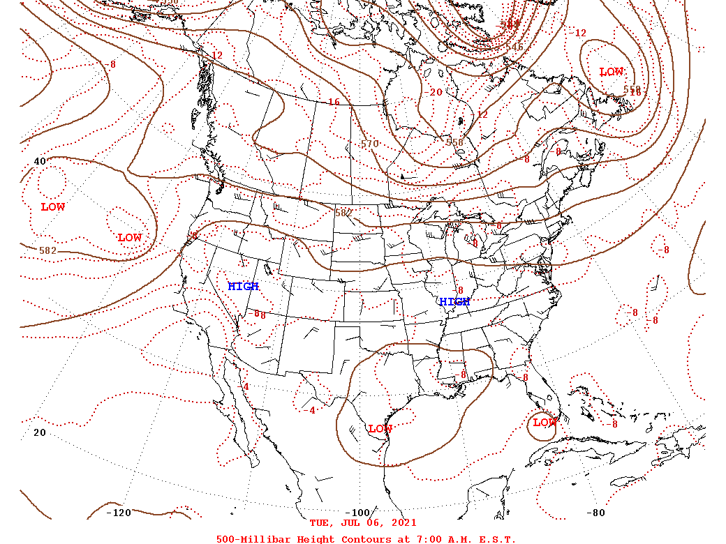 |
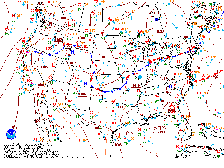 |
| Loop of 12z 500 mb Analysis from 7-6 to 7-9 (24-h increments) | Loop of WPC Surface Analysis from 00z on 7-8 (8 PM EDT 7/7) to 06z/2 AM EDT on 7-9 (6-h increments) |
Near-storm environment summary.
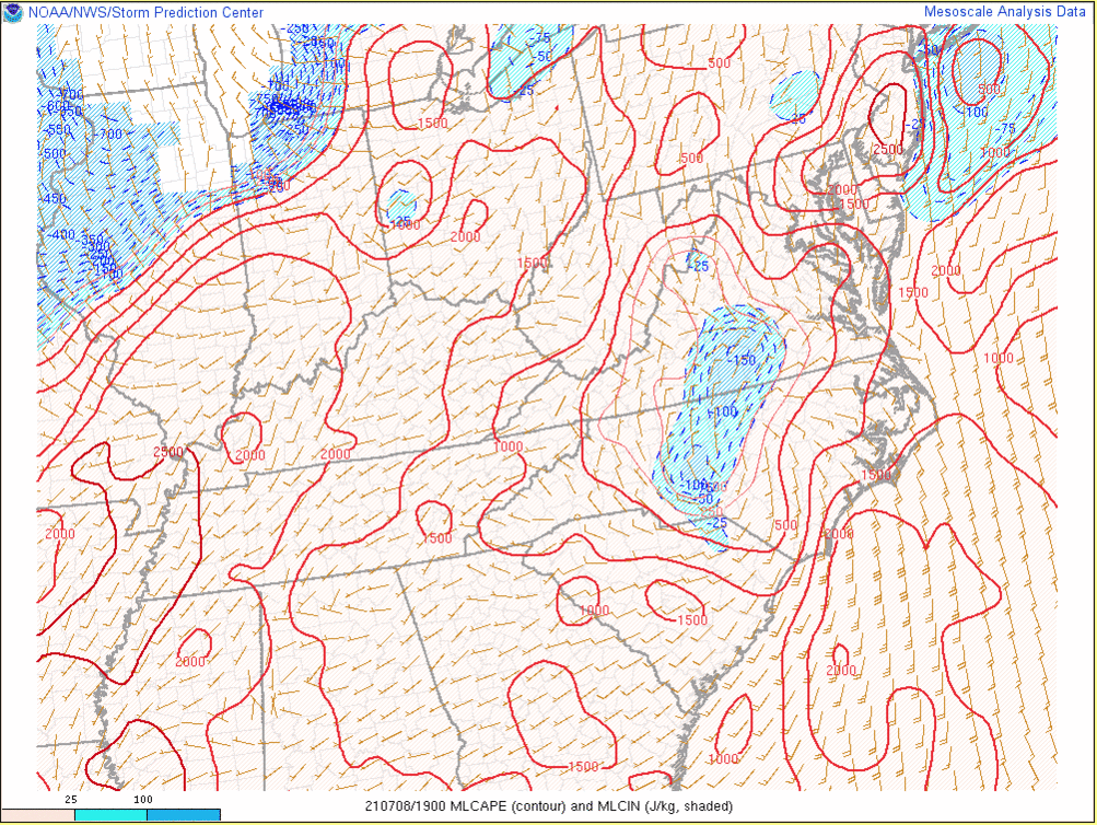 |
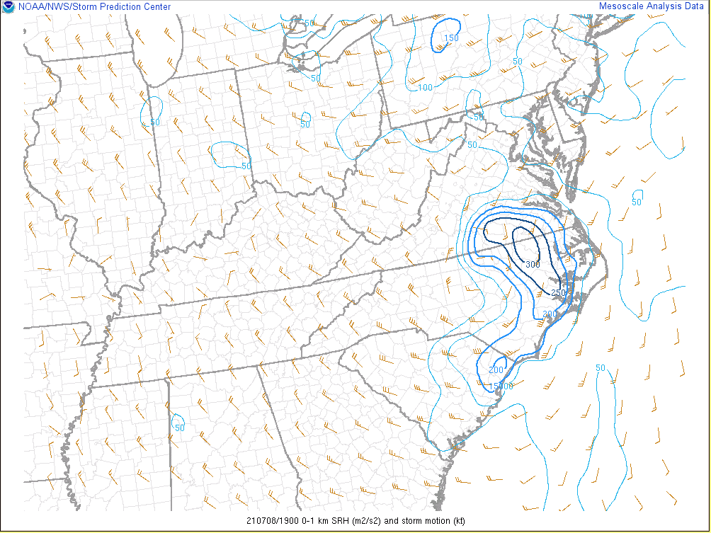 |
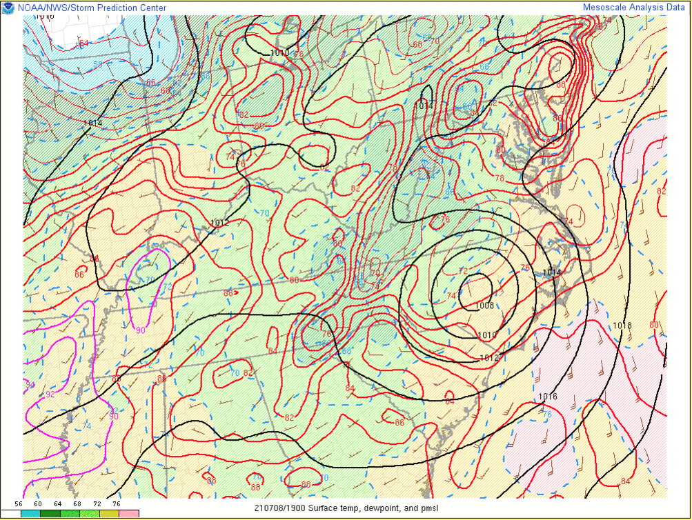 |
| Loop of MLCAPE/MLCIN from 3 PM to 9 PM on 7/8 in 2 hour increments | Loop of 0-1 km SRH from 3 PM to 9 PM on 7/8 in 2 hour increments | Loop of T/Td/MSLP from 3 PM on 7/8 to 1 AM on 7/9 in 2 hour increments |
 |
Media use of NWS Web News Stories is encouraged! Please acknowledge the NWS as the source of any news information accessed from this site. |
|


 Coastal Flood
 Heat
Heat