Overview
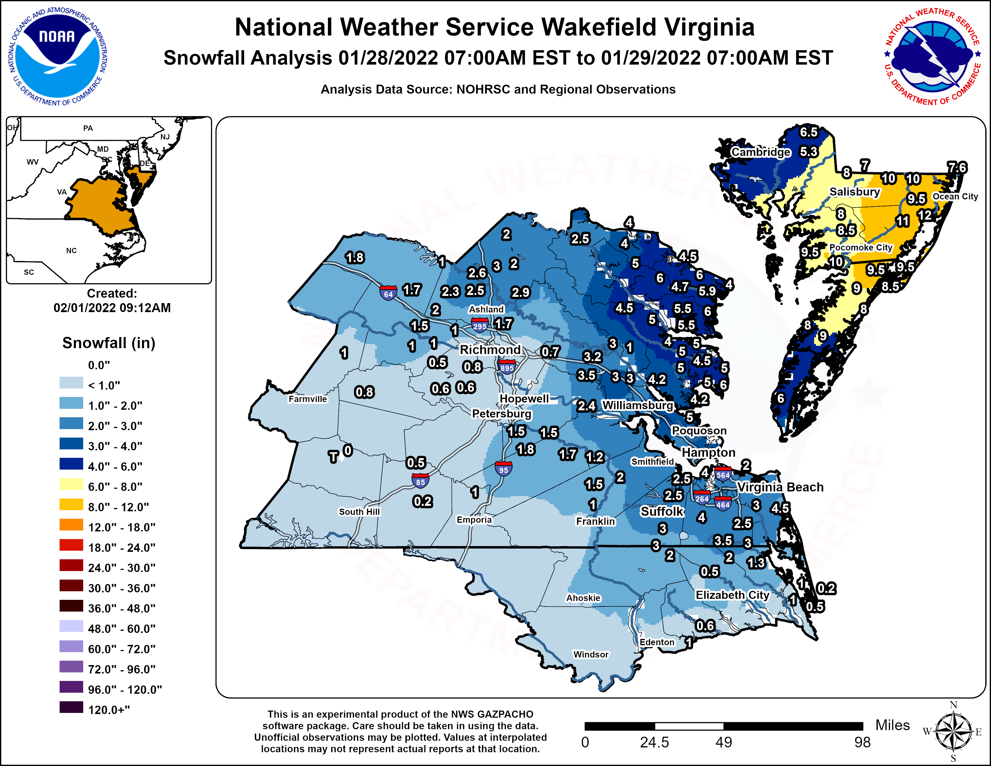
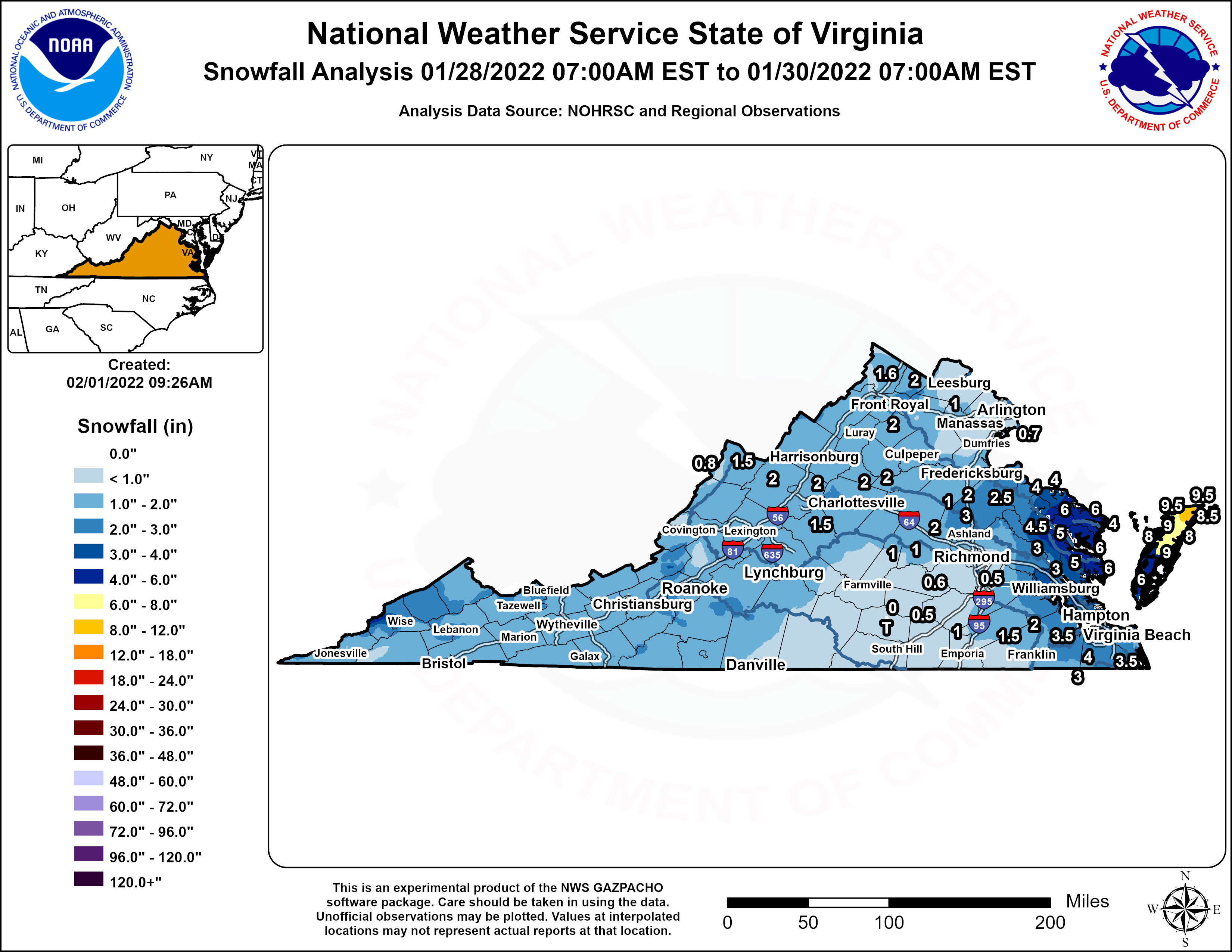
A strong northern stream shortwave dropping SSE from the Canadian Prairies phased with a southern stream wave tracking eastward from the southern Plains to the coastal Carolinas from 1/27 through the morning of 1/29. A closed upper low quickly formed by the evening of the 29th as the phased shortwave tracked just off the northeast US coast. Meanwhile, at the surface, low pressure formed along a cold front off the coast of Georgia during the day on 1/28, while a secondary, Arctic cold front approached the local area from the south. A band of snow (associated with mid-level frontogenesis) slowly tracked across the northwest half of the area during the evening of the 28th, dropping a quick 1-3" from north of Farmville to Colonial Beach. The surface low offshore of the GA/SC coast rapidly deepened as it tracked NNE off the Mid-Atlantic coast during the early morning hours of 1/29 (this was a classic "Miller A" setup). The low deepened even further as it approached Cape Cod during the day on 1/29. A large area of moderate to occasionally heavy snow set up near the coast while the band that was inland weakened overnight. The heaviest snow was confined to an area near a band of 700mb frontogenesis (with the 700mb layer in the dendritic growth zone). There was also some transient slantwise and even upright instability just above the 700mb layer during the early morning on 1/29 on the eastern shore, resulting in bands of 1.5-2"/hour snow rates at times. In addition, temperatures dropped below freezing during the early morning hours of the 29th as winds turned from the N to NNW as that secondary cold front/cold air advection push crossed the area. Snow ended from SSW to NNE during the morning and midday hours of 1/29 as temperatures fell into the 20s. Some very impressive (8-14") snow totals were observed over the Lower Eastern Shore, with 2-6" from Hampton Roads to the VA Northern Neck, and 0.5-3" inland. While the snow that fell initially (during the evening of 1/28) was heavy and wet (with temperatures right around 32F), the snow became powdery and drier at the tail end of the event as temperatures dropped into the 20s. Combined with N-NW winds gusting to 35-45mph on the Lower Eastern, blizzard conditions occurred. In fact, these were the first Blizzard Warnings issued for anywhere in the Wakefield CWA since early January of 2018. Even after the snow ended, Salisbury Airport (KSBY) reported several hours of blowing snow with visibilities of around 3 miles.
Snowfall Map
Photos
Selected Storm Photos
 |
 |
 |
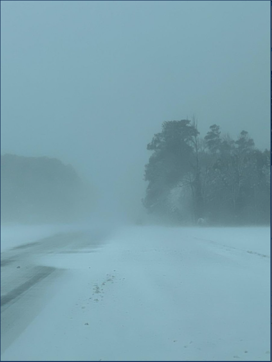
| Blizzard Conditions on the Virginia Eastern Shore (source: VA State Police) |
Ocean Pines, MD (source: mybrudderandme-Twitter) |
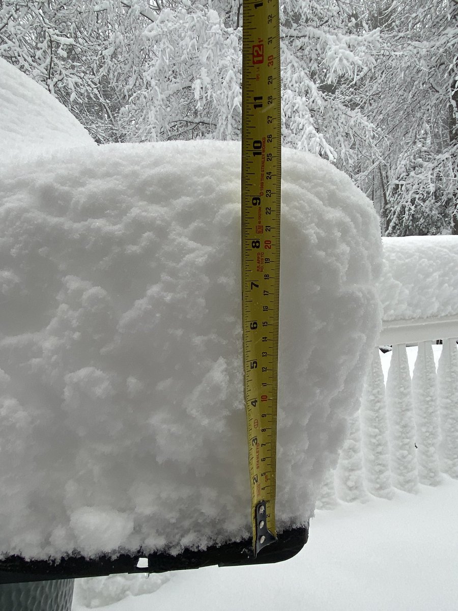
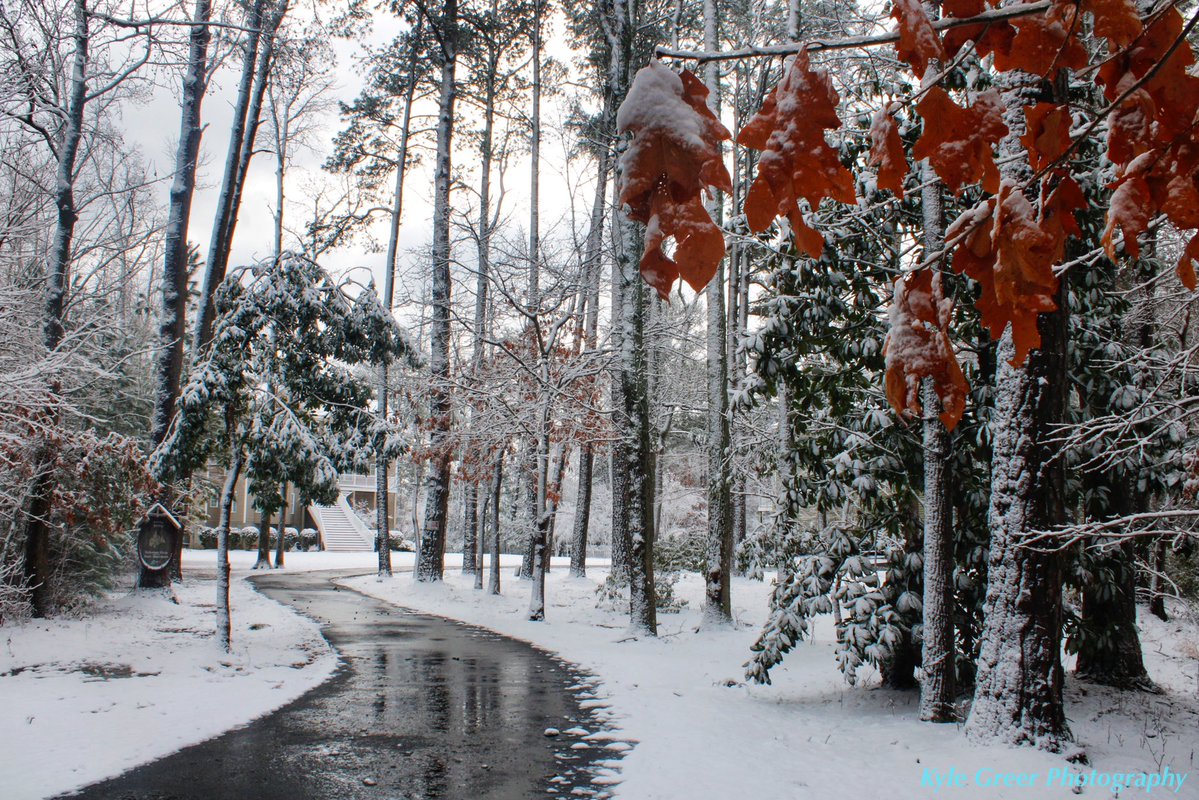
Hampton, VA (source: Kyle Greer) |
Radar
Selected Radar Loops
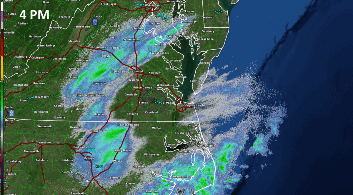 |
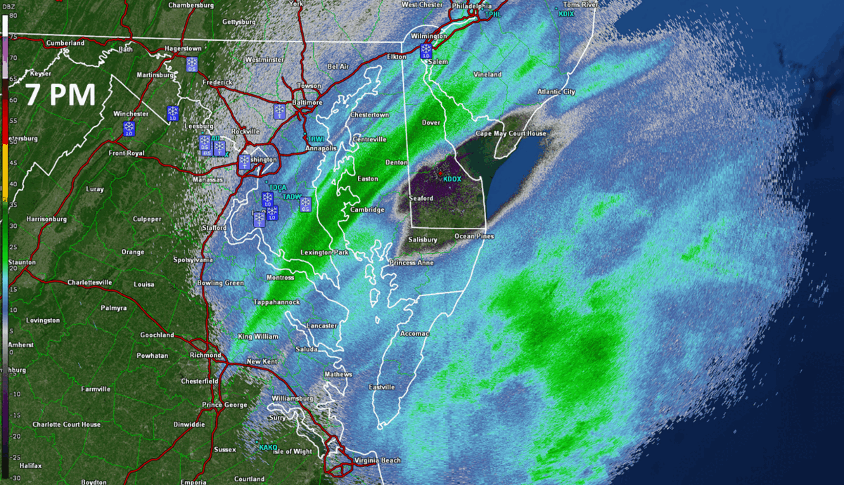 |
| Loop of KAKQ Radar from 4 PM on 1/28 to 7 AM on 1/29 in 30 minute increments. | Loop of KDOX Radar from 7 PM on 1/28 to 11 AM on 1/29 in 30 minute increments. |
Storm Reports
Public Information Statement
National Weather Service Wakefield VA
508 PM EST Sat Jan 29 2022

...SNOWFALL REPORTS...

Location                     Amount    Time/Date       Lat/Lon

...Maryland...

...Dorchester County...
1 W Hurlock                  6.5 in    1138 AM 01/29   38.63N/75.89W
2 ENE East New Market        5.5 in    0808 AM 01/29   38.61N/75.89W
Hurlock 1.9 SW               5.5 in    0800 AM 01/29   38.61N/75.89W
East New Market 1.9 SE       5.3 in    0400 AM 01/29   38.58N/75.90W
Cambridge                    5.0 in    0921 AM 01/29   38.57N/76.08W

...Somerset County...
2 NNW Marion Station         10.0 in   0954 AM 01/29   38.04N/75.74W
Marion Station 1.7 S         9.5 in    0700 AM 01/29   38.02N/75.77W
Princess Anne 2.1 SSW        8.5 in    1220 PM 01/29   38.17N/75.71W
Princess Anne                8.0 in    0431 PM 01/29   38.21N/75.70W

...Wicomico County...
Parsonsburg                  10.0 in   0700 AM 01/29   38.39N/75.47W
1 SSW Salisbury              10.0 in   1054 AM 01/29   38.36N/75.60W
Willards                     10.0 in   1229 PM 01/29   38.39N/75.35W
1 NW Lakewood                9.5 in    0436 PM 01/29   38.34N/75.60W
Parsonsburg 1.6 WNW          9.5 in    0738 AM 01/29   38.39N/75.50W
1 NNE Salisbury              9.5 in    0920 AM 01/29   38.39N/75.58W
1 ENE Hebron                 8.0 in    1232 PM 01/29   38.42N/75.67W
Delmar                       7.0 in    0917 AM 01/29   38.45N/75.57W
Delmar 0.3 ESE               6.0 in    0600 AM 01/29   38.45N/75.57W

...Worcester County...
1 NW Ocean Pines             14.0 in   0838 AM 01/29   38.40N/75.16W
Ocean Pines 0.9 SSW          12.5 in   0700 AM 01/29   38.37N/75.16W
Newark                       12.0 in   1118 AM 01/29   38.25N/75.30W
1 SSW Ocean Pines            12.0 in   0432 PM 01/29   38.37N/75.16W
1 S West Ocean City          12.0 in   0837 AM 01/29   38.34N/75.11W
Snow Hill                    11.0 in   0836 AM 01/29   38.17N/75.40W
Berlin                       9.5 in    0809 AM 01/29   38.32N/75.22W
Bishopville 3.1 E            7.6 in    0500 AM 01/29   38.45N/75.13W

...North Carolina...

...Chowan County...
3 SSW Somerset               1.0 in    1001 AM 01/29   36.02N/76.48W

...Currituck County...
4 NW Moyock                  3.0 in    0716 AM 01/29   36.53N/76.18W
4 WSW Moyock                 2.0 in    1058 AM 01/29   36.46N/76.20W
Moyock 1.8 SSE               1.3 in    0600 AM 01/29   36.50N/76.16W
Aydlett                      1.0 in    0922 AM 01/29   36.32N/75.90W
Grandy                       1.0 in    0811 AM 01/29   36.25N/75.88W
Grandy 0.6 E                 0.5 in    0700 AM 01/29   36.24N/75.87W
Corolla 5.8 SSE              0.2 in    0700 AM 01/29   36.30N/75.80W

...Gates County...
Corapeake                    2.0 in    1227 PM 01/29   36.54N/76.58W

...Pasquotank County...
Elizabeth City 2.6 W         1.5 in    0700 AM 01/29   36.30N/76.27W
Elizabeth City 0.8 NW        0.9 in    0800 AM 01/29   36.30N/76.23W
Elizabeth City 11.7 WNW      0.5 in    0844 AM 01/29   36.38N/76.40W

...Perquimans County...
Hertford 6.0 SSE             0.6 in    0700 AM 01/29   36.11N/76.42W

...Virginia...

...Accomack County...
Greenbackville 0.4 WNW       9.5 in    0700 AM 01/29   38.01N/75.40W
1 S Oak Hall                 9.5 in    0804 AM 01/29   37.92N/75.55W
Bloxom                       9.0 in    1120 AM 01/29   37.83N/75.62W
Painter                      9.0 in    0718 AM 01/29   37.59N/75.79W
Wallops Island               8.5 in    0733 AM 01/29   37.84N/75.48W
2 SW Harborton               8.0 in    0740 AM 01/29   37.64N/75.87W
Metompkin 0.9 SE             8.0 in    0700 AM 01/29   37.76N/75.59W

...Amelia County...
Jetersville 3.6 W            0.8 in    0800 AM 01/29   37.30N/78.16W

...Brunswick County...
Alberta 5 N                  0.5 in    0800 AM 01/29   36.94N/77.90W
Lawrenceville 1.2 SSW        0.2 in    0700 AM 01/29   36.74N/77.86W

...Caroline County...
Ruther Glen 1.7 ENE          3.0 in    0700 AM 01/29   37.94N/77.43W
Hanover 3.0 N                2.9 in    0700 AM 01/29   37.81N/77.36W
Penola                       2.0 in    0919 PM 01/28   37.96N/77.37W
Woodford                     2.0 in    0759 AM 01/29   38.11N/77.41W

...Chesterfield County...
3 SSE Midlothian             0.8 in    0931 AM 01/29   37.47N/77.61W
3.9 SW Beach                 0.6 in    0700 AM 01/29   37.32N/77.65W
Chesterfield 8.5 WSW         0.6 in    0700 AM 01/29   37.33N/77.64W
2 SSE Chester                0.5 in    0729 AM 01/29   37.33N/77.42W
2 NW Midlothian              0.5 in    0919 AM 01/29   37.53N/77.67W
Moseley 1.7 NNE              0.5 in    0700 AM 01/29   37.44N/77.70W

...City of Chesapeake County...
Deep Creek                   4.0 in    0850 AM 01/29   36.73N/76.35W
3 SSE Hickory                3.5 in    0827 AM 01/29   36.62N/76.21W
2 NE South Norfolk           3.5 in    0706 AM 01/29   36.82N/76.25W
Chesapeake 4.3 ENE           2.5 in    0700 AM 01/29   36.70N/76.23W
1 SE Huntersville            2.5 in    0945 AM 01/29   36.86N/76.42W
Chesapeake 1.8 NE            2.0 in    0700 AM 01/29   36.69N/76.28W

...City of Emporia County...
Emporia Reservoir            0.5 in    0700 AM 01/29   36.70N/77.56W

...City of Hampton County...
Hampton 1.9 NW               4.0 in    0600 AM 01/29   37.07N/76.32W
2 SSE Langley View           4.0 in    0613 AM 01/29   37.05N/76.35W
2 E Northampton              4.0 in    1008 AM 01/29   37.04N/76.39W
1 WSW Raleigh Terrace        3.3 in    0700 AM 01/29   36.99N/76.39W
2 ESE Langley View           3.0 in    0704 AM 01/29   37.05N/76.33W
1 ESE Hallwood               2.3 in    0712 AM 01/29   37.06N/76.28W
Hampton 3.4 W                2.3 in    0823 AM 01/29   37.05N/76.36W

...City of Newport News County...
2 NNE Oriana                 4.0 in    0859 AM 01/29   37.16N/76.51W
Beaconsdale                  3.0 in    0627 AM 01/29   37.06N/76.47W
Newport News 2.7 ESE         3.0 in    0600 AM 01/29   37.06N/76.47W
Newport News 3.3 E           3.0 in    0500 AM 01/29   37.08N/76.45W
1 SSE Patrick Henry Fiel     3.0 in    0706 AM 01/29   37.12N/76.49W

...City of Norfolk County...
2 E Downtown Norfolk         3.5 in    0925 AM 01/29   36.85N/76.25W
Norfolk 5.0 SSW              3.0 in    0700 AM 01/29   36.86N/76.29W
Norfolk 1.6 NNW              2.4 in    0700 AM 01/29   36.94N/76.26W
2 NNE Norfolk International  2.0 in    0826 AM 01/29   36.93N/76.19W

...City of Poquoson County...
1 SW Poquoson                4.0 in    0820 AM 01/29   37.12N/76.39W
Poquoson 6.1 WSW             4.0 in    0700 AM 01/29   37.12N/76.39W

...City of Portsmouth County...
2 NNE Churchland             4.0 in    0747 AM 01/29   36.89N/76.39W
1 NW Cradock                 3.5 in    0827 AM 01/29   36.80N/76.33W
2 W Cradock                  3.5 in    1107 AM 01/29   36.80N/76.36W
Portsmouth 4.1 SSE           3.5 in    0700 AM 01/29   36.80N/76.33W
2 NNW Cradock                3.0 in    0659 AM 01/29   36.82N/76.33W
2 ESE Western Branch         3.0 in    0357 AM 01/29   36.82N/76.38W

...City of Richmond County...
Richmond 4.2 NNE             0.4 in    0700 AM 01/29   37.59N/77.45W
Richmond 1.7 N               0.2 in    0700 AM 01/29   37.56N/77.47W

...City of Suffolk County...
2 NNW Kilby                  3.5 in    1003 AM 01/29   36.75N/76.65W
Suffolk 2.9 NNW              3.2 in    0700 AM 01/29   36.74N/76.66W
6 S Saunders                 3.0 in    1009 AM 01/29   36.55N/76.58W
1 SW Suffolk Airport         3.0 in    0433 PM 01/29   36.68N/76.61W
3 NW Magnolia                2.5 in    0655 AM 01/29   36.77N/76.58W
1 NE Huntersville            2.0 in    0736 AM 01/29   36.89N/76.42W
Portsmouth 4.0 WNW           2.0 in    0700 AM 01/29   36.89N/76.42W
Suffolk 1.4 NNW              2.0 in    0730 AM 01/29   36.72N/76.65W
Portsmouth 5.1 WNW           1.8 in    0700 AM 01/29   36.88N/76.44W

...City of Virginia Beach County...
Virginia Beach 2.4 N         4.5 in    0700 AM 01/29   36.77N/76.04W
Virginia Beach 8.1 N         4.3 in    0700 AM 01/29   36.86N/76.05W
Princess Anne Plaz           4.0 in    0654 AM 01/29   36.83N/76.09W
2 SSW Gallups Corner         3.0 in    1232 PM 01/29   36.77N/76.14W
Virginia Beach 3.2 E         3.0 in    0830 AM 01/29   36.74N/75.99W
Virginia Beach 8.5 N         2.1 in    0800 AM 01/29   36.86N/76.03W

...City of Williamsburg County...
Williamsburg 1.4 ENE         3.5 in    0700 AM 01/29   37.28N/76.68W
Williamsburg 1.3 SSW         2.5 in    0700 AM 01/29   37.25N/76.72W
Williamsburg                 2.0 in    0652 AM 01/29   37.27N/76.71W
Williamsburg 1.0 SSW         1.9 in    0600 AM 01/29   37.26N/76.71W

...Cumberland County...
1 NE Cumberland              1.0 in    0934 AM 01/29   37.50N/78.24W

...Essex County...
1 NW Loretto                 2.5 in    0910 AM 01/29   38.08N/77.06W

...Gloucester County...
1 ENE Dutton                 5.0 in    0920 AM 01/29   37.50N/76.46W
Ware Neck                    5.0 in    1005 AM 01/29   37.40N/76.45W
1 WNW Gloucester Courthouse  4.5 in    0908 AM 01/29   37.42N/76.54W
Gloucester Point             4.3 in    0813 AM 01/29   37.27N/76.50W
Gloucester Courthouse 3.3 SS 4.2 in    0800 AM 01/29   37.37N/76.55W
Gloucester Point 2.4 E       4.2 in    0700 AM 01/29   37.26N/76.45W
Gloucester Courthouse 0.7 NN 4.0 in    0800 AM 01/29   37.42N/76.53W
Gloucester Courthouse 5.8 SS 4.0 in    0800 AM 01/29   37.33N/76.57W
Gloucester Point 0.6 S       3.8 in    0700 AM 01/29   37.26N/76.50W
Gloucester Courthouse        3.5 in    0713 AM 01/29   37.41N/76.53W
1 SSE Gloucester Courthouse  3.5 in    0715 AM 01/29   37.40N/76.52W
Gloucester Courthouse 3.3 SE 3.2 in    0830 AM 01/29   37.37N/76.49W
Gloucester Courthouse 3.8 EN 3.1 in    0800 AM 01/29   37.42N/76.46W
Achilles                     3.0 in    0657 AM 01/29   37.28N/76.44W

...Goochland County...
Manakin-Sabot 1.6 SW         1.6 in    0700 AM 01/29   37.63N/77.74W
Crozier                      1.5 in    0700 AM 01/29   37.63N/77.80W

...Greensville County...
1 N Cowie Corner             1.0 in    1155 PM 01/28   36.79N/77.57W

...Hanover County...
Beaverdam 4.3 ESE            2.6 in    0700 AM 01/29   37.91N/77.59W
Montpelier 4.8 E             2.5 in    0719 AM 01/29   37.82N/77.59W
3 NNW Gilman                 2.3 in    0941 AM 01/29   37.81N/77.60W
1 W Ashland                  2.0 in    1200 AM 01/29   37.76N/77.49W
1 SW Ashland                 2.0 in    1029 AM 01/29   37.76N/77.49W
Rockville 5.1 W              2.0 in    0700 AM 01/29   37.72N/77.77W

...Henrico County...
1 ESE Longdale               1.7 in    1127 PM 01/28   37.65N/77.45W
1 NE Longdale                1.5 in    1050 PM 01/28   37.67N/77.46W
Glen Allen 4.6 W             1.4 in    0718 AM 01/29   37.66N/77.57W
3 N Short Pump               1.3 in    1007 AM 01/29   37.70N/77.61W
Glen Allen 6.6 W             1.0 in    0700 AM 01/29   37.67N/77.60W
Henrico 5.8 W                0.8 in    0830 AM 01/29   37.64N/77.65W
Richmond International       0.7 in    1045 AM 01/29   37.51N/77.32W
Sandston 5.9 ESE             0.7 in    0744 AM 01/29   37.51N/77.21W
Richmond 5.3 NW              0.5 in    0700 AM 01/29   37.59N/77.54W
Montrose 4.7 SSE             0.2 in    0700 AM 01/29   37.46N/77.35W

...Isle of Wight County...
Smithfield                   2.3 in    0700 AM 01/29   36.98N/76.62W
Zuni                         2.0 in    0800 AM 01/29   36.87N/76.83W
1 W Lees Mill                1.0 in    1004 AM 01/29   36.68N/76.91W

...James City County...
Toano 1.1 SSW                3.7 in    0700 AM 01/29   37.37N/76.81W
Williamsburg 6.5 NW          3.7 in    0700 AM 01/29   37.35N/76.77W
Williamsburg 3.8 WSW         3.3 in    0700 AM 01/29   37.24N/76.77W
Williamsburg 3.2 NW          3.2 in    0800 AM 01/29   37.30N/76.75W
Williamsburg 3.5 W           3.2 in    0700 AM 01/29   37.28N/76.77W
Norge                        3.0 in    0817 AM 01/29   37.37N/76.78W
Williamsburg 9.1 NNW         3.0 in    0700 AM 01/29   37.39N/76.78W
2 NE Governors Land          2.9 in    0807 AM 01/29   37.27N/76.81W
Williamsburg 5.1 WSW         2.8 in    0700 AM 01/29   37.25N/76.80W
Williamsburg 2.6 WSW         2.5 in    0800 AM 01/29   37.26N/76.75W
Williamsburg 3.2 WNW         2.5 in    0700 AM 01/29   37.28N/76.76W
Williamsburg 3.4 W           2.4 in    0700 AM 01/29   37.27N/76.77W
1 SSE Ewell                  2.0 in    0913 AM 01/29   37.31N/76.74W

...King William County...
West Point                   3.0 in    0829 AM 01/29   37.55N/76.80W

...King and Queen County...
3 SW Ino                     4.5 in    0835 AM 01/29   37.73N/76.83W
Mattaponi                    1.0 in    0824 AM 01/29   37.53N/76.78W

...Lancaster County...
Kilmarnock                   6.0 in    0912 AM 01/29   37.71N/76.38W
Mollusk                      5.5 in    0700 AM 01/29   37.73N/76.54W
Urbanna 6.2 NNE              5.5 in    0700 AM 01/29   37.72N/76.52W

...Louisa County...
Gordonsville 10.4 S          1.8 in    0700 AM 01/29   37.99N/78.21W
Gum Spring 3.5 NNW           1.7 in    0647 AM 01/29   37.82N/77.92W
Bumpass                      1.0 in    0802 AM 01/29   37.97N/77.74W

...Lunenburg County...
Victoria 0.9 N                T in     0700 AM 01/29   37.01N/78.22W

...Mathews County...
Port Haywood 1.0 SE          6.0 in    0700 AM 01/29   37.37N/76.31W
1 SW Diggs                   5.0 in    1100 AM 01/29   37.42N/76.30W
Port Haywood                 5.0 in    0907 AM 01/29   37.39N/76.31W
Fort Nonsense                4.5 in    0703 AM 01/29   37.46N/76.44W

...Middlesex County...
Urbanna                      5.5 in    0933 AM 01/29   37.64N/76.58W
1 ESE Church View            5.0 in    1052 AM 01/29   37.67N/76.67W
Hartfield                    5.0 in    0819 AM 01/29   37.55N/76.44W
Locust Hill 1.1 ENE          5.0 in    0700 AM 01/29   37.61N/76.49W
White Stone 8.0 SSW          5.0 in    0700 AM 01/29   37.54N/76.44W
Saluda                       4.0 in    0909 AM 01/29   37.61N/76.59W
Hartfield 2.9 W              3.5 in    0700 AM 01/29   37.54N/76.50W

...New Kent County...
Lanexa                       3.5 in    0822 AM 01/29   37.42N/76.90W
Providence Forge 3.7 NE      3.2 in    0800 AM 01/29   37.48N/77.00W

...Northampton County...
Cape Charles                 6.0 in    0933 AM 01/29   37.27N/76.01W

...Northumberland County...
1 SSE Avalon                 6.0 in    0913 AM 01/29   37.90N/76.42W
Heathsville 4.6 SE           5.9 in    0700 AM 01/29   37.87N/76.42W
Heathsville                  4.7 in    0811 AM 01/29   37.92N/76.47W
Lottsburg 2.3 NNE            4.5 in    0700 AM 01/29   37.99N/76.51W
Reedville                    4.0 in    0808 AM 01/29   37.85N/76.27W

...Powhatan County...
Powhatan 7.8 NE              1.0 in    0800 AM 01/29   37.59N/77.79W
Worshams                     1.0 in    0919 AM 01/29   37.54N/77.89W

...Prince Edward County...
Farmville 1.0 SSW            0.7 in    0700 AM 01/29   37.28N/78.40W

...Prince George County...
2 SSW Templeton              1.8 in    0903 AM 01/29   37.05N/77.34W
Disputanta                   1.5 in    0830 AM 01/29   37.13N/77.23W
1 N Prince George Golf       1.5 in    0600 AM 01/29   37.15N/77.26W
Disputanta 6.3 NE            1.2 in    0700 AM 01/29   37.19N/77.15W
2 SSE Fort Lee               1.0 in    1010 AM 01/29   37.21N/77.32W

...Richmond County...
Farnham                      6.0 in    0423 AM 01/29   37.88N/76.63W
1 ESE Warsaw                 5.0 in    0938 AM 01/29   37.96N/76.75W

...Southampton County...
Sedley 3.7 N                 1.5 in    0700 AM 01/29   36.83N/76.99W
2 NNW Hunterdale             1.0 in    0730 AM 01/29   36.73N/76.97W
Franklin 2.6 WNW             0.5 in    0800 AM 01/29   36.70N/76.98W

...Surry County...
Claremont 0.2 SW             2.4 in    0705 AM 01/29   37.23N/76.97W

...Sussex County...
1 NW Wakefield               1.7 in    0530 AM 01/29   36.98N/77.01W
Wakefield 0.1 ENE            1.2 in    0800 AM 01/29   36.97N/76.99W

...Westmoreland County...
1 NW Currioman Landing       4.0 in    1230 PM 01/29   38.17N/76.78W
1 ENE Montross               4.0 in    0911 AM 01/29   38.10N/76.81W

...York County...
Grafton                      5.0 in    1234 PM 01/29   37.17N/76.47W
1 WSW Yorktown               4.0 in    0812 AM 01/29   37.23N/76.52W
3 SE Tabb                    3.8 in    1200 PM 01/29   37.10N/76.43W
Newport News 5.5 ENE         3.3 in    0700 AM 01/29   37.11N/76.42W
2 SW Poquoson                3.0 in    0244 AM 01/29   37.11N/76.42W
1 ESE Seaford                3.0 in    0829 AM 01/29   37.19N/76.41W
Newport News 5.8 NE          2.5 in    0700 AM 01/29   37.14N/76.45W
Yorktown 6.8 SE              1.7 in    0800 AM 01/29   37.15N/76.45W
&&
Environment
Synoptic summary.
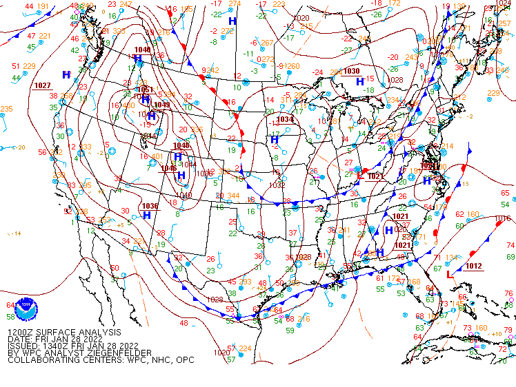 |
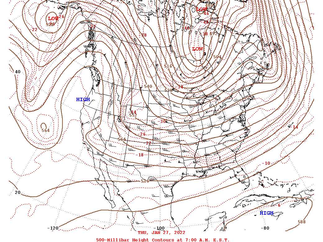 |
| Loop of WPC Surface Analysis from 7 AM on 1/28 to 7 PM on 1/29 | 500 mb Analysis Loop from 7 AM on 1/27 to 7 AM on 1/29 |
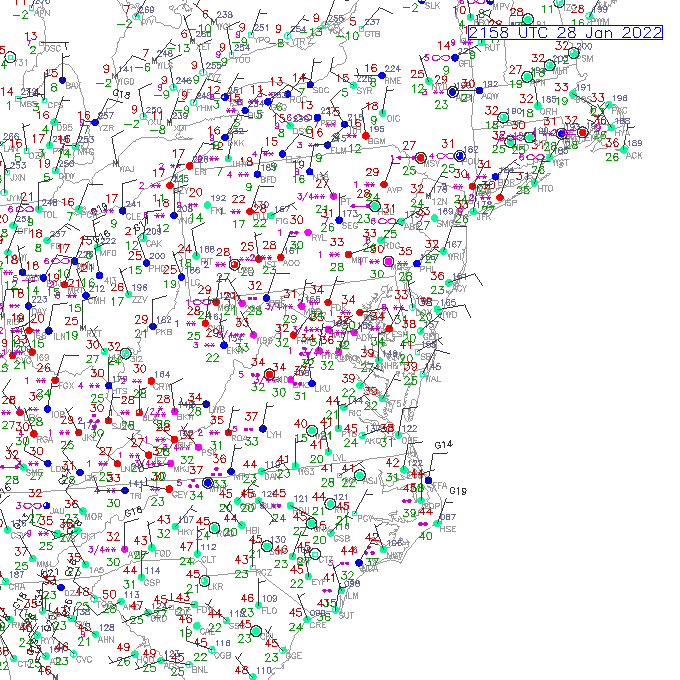
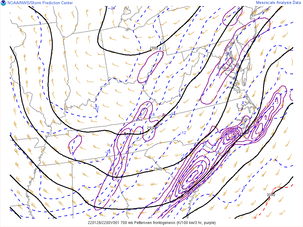
Near-storm environment and observations.
 |
 |
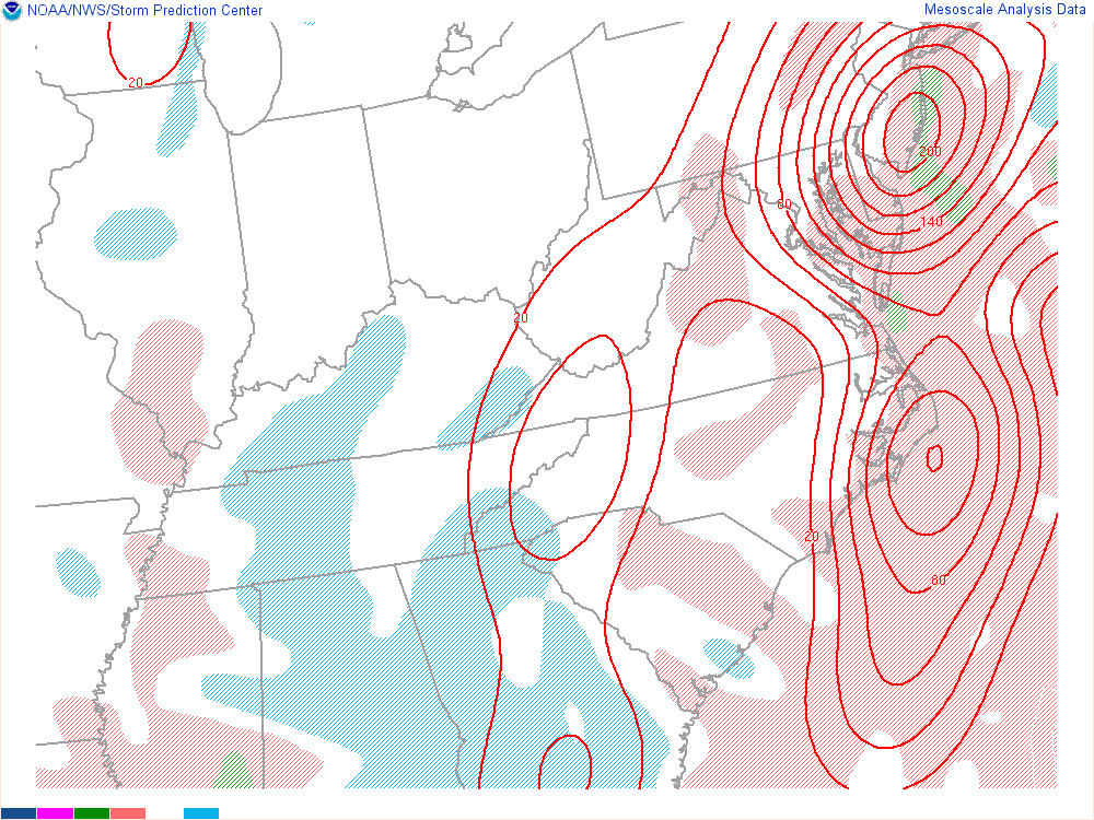 |
| Loop of Observations for the duration of the event. | Loop of 700mb Frontogenesis from 7 PM on 1/28 to 7 AM on 1/29 | Loop of 650-500mb Equivalent Potential Vorticity from midnight to 7 AM on 1/29. Negative EPV values indicate the presence of slantwise instability, which is a signal for banded snowfall. |
Additional environmental data.
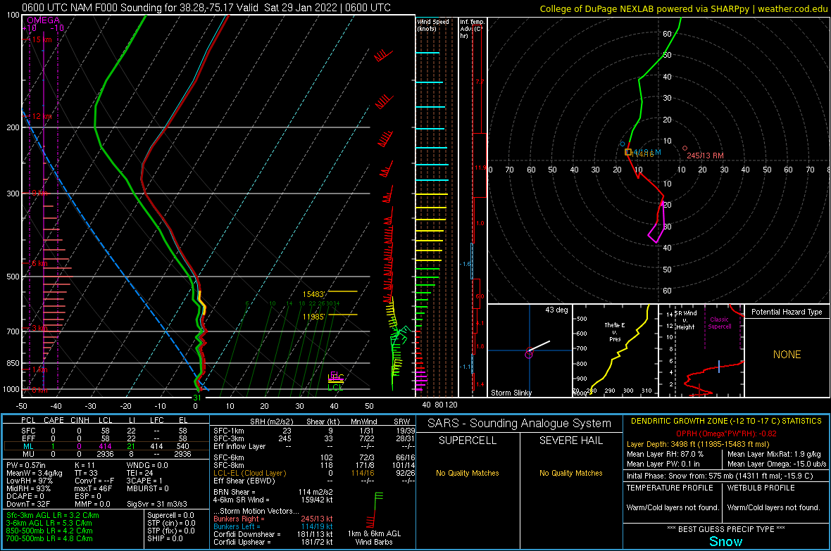 |
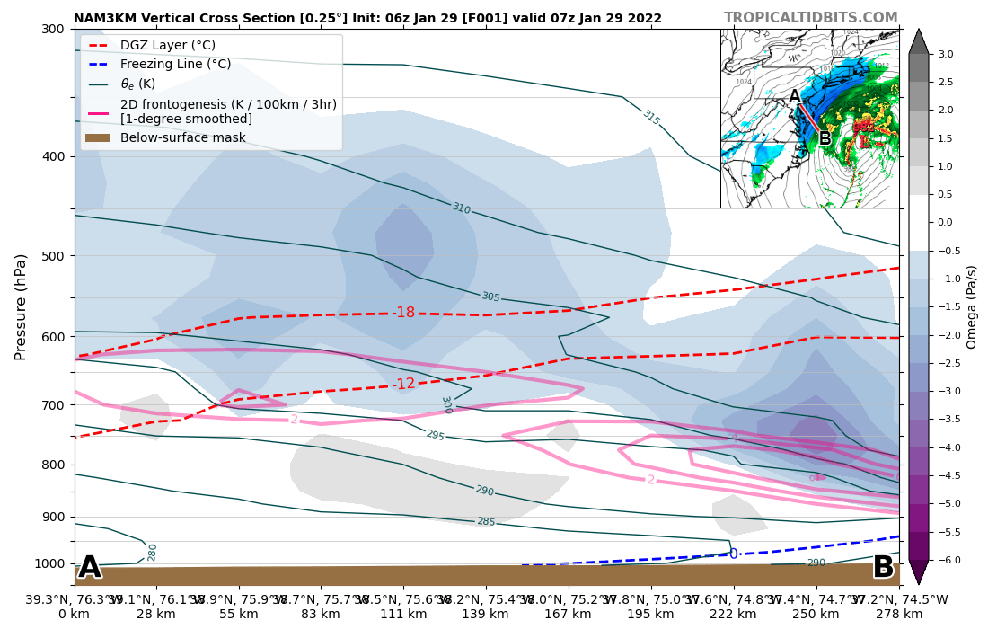 |
| 06z/1 AM NAMNest Analysis Sounding from Ocean City, MD (KOXB). | 07z/2AM NAMNest 1 hour forecast Frontogenesis/Theta-E Cross section. |
 |
Media use of NWS Web News Stories is encouraged! Please acknowledge the NWS as the source of any news information accessed from this site. |
|


 Coastal Flood
 Heat
Heat