Overview
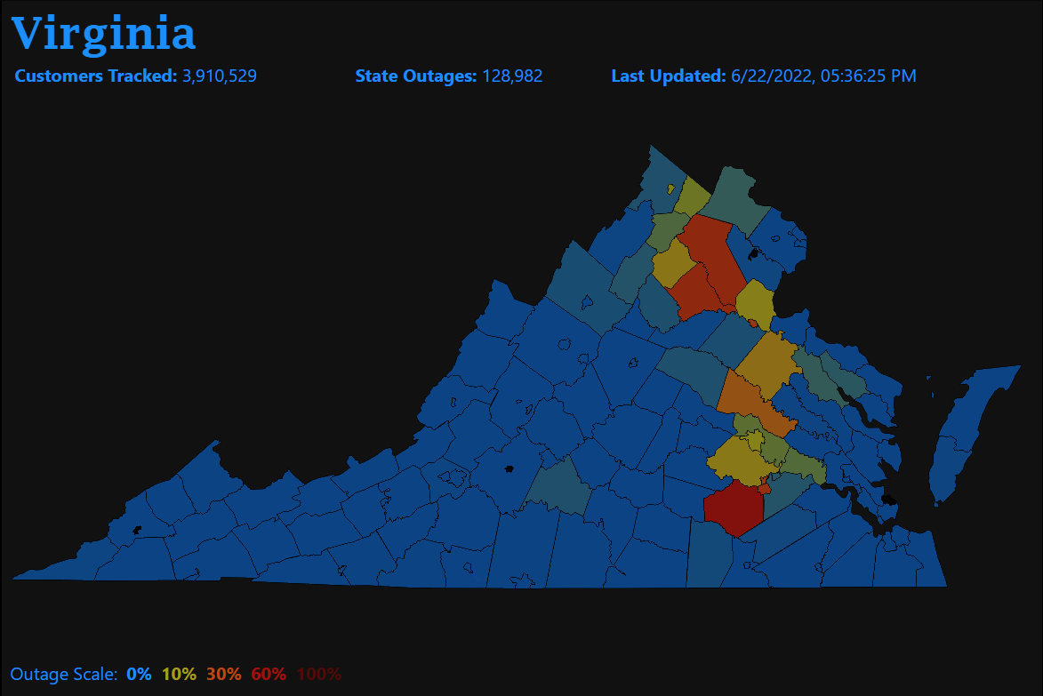
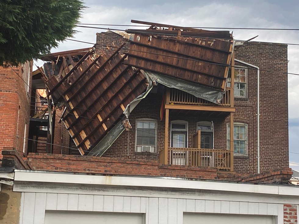
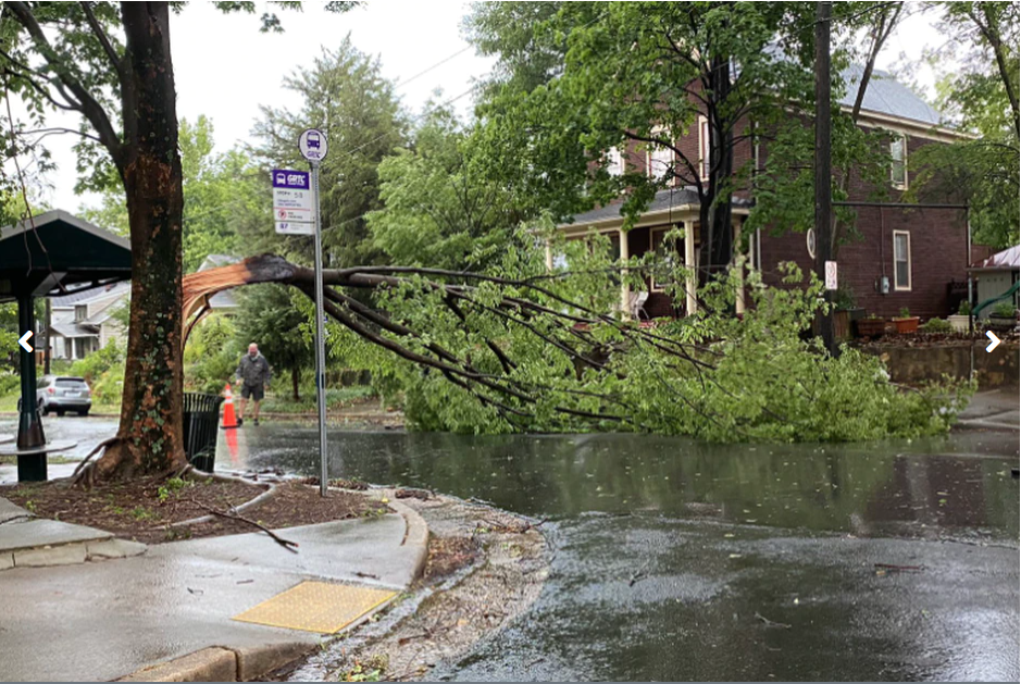
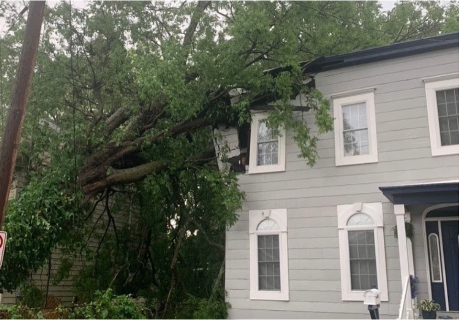
A severe thunderstorm quickly tracked from north to south from Fredericksburg through the Richmond Metro between 2 and 4:30 PM on 6/22. The track roughly followed I-95. Widespread tree and power line damage was observed, and there were close to 100,000 power outages in the Richmond metro alone at one point. While measured gusts topped out around 60 mph, there were likely 80 mph winds in a few spots along the path of the storm. Some of the worst damage occurred in Richmond, where the roof was ripped off of an apartment complex. To put it in perspective, our office has only issued a Severe Thunderstorm Warning with an 80 mph (now also known as Destructive) tag two times before (going back to 2010). To put a number on it, for approximately every 1000 SVRs that we have issued, only one has the 80 mph wind tag. Note that SVSs are not included in this calculation.
In addition, this was quite an unusual setup with northerly to northwesterly flow over a fairly deep layer and a complex surface pattern with higher dew points/instability to the north. While the model soundings indicated a threat for localized severe winds, nothing stood out that pointed towards a significant (75+mph) wind event. See Environment section for more details. This page may be updated with more details in the coming days.
Photos
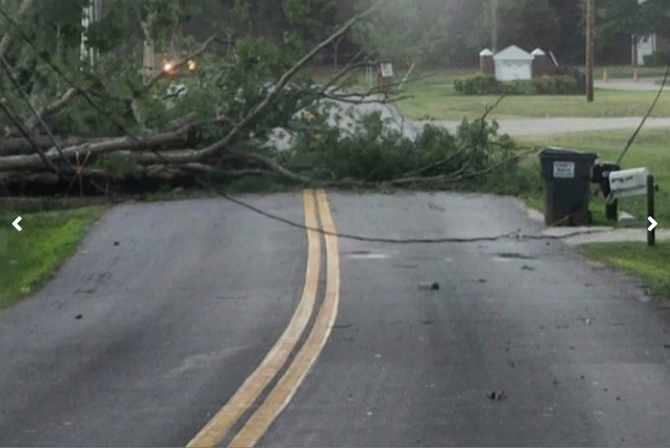
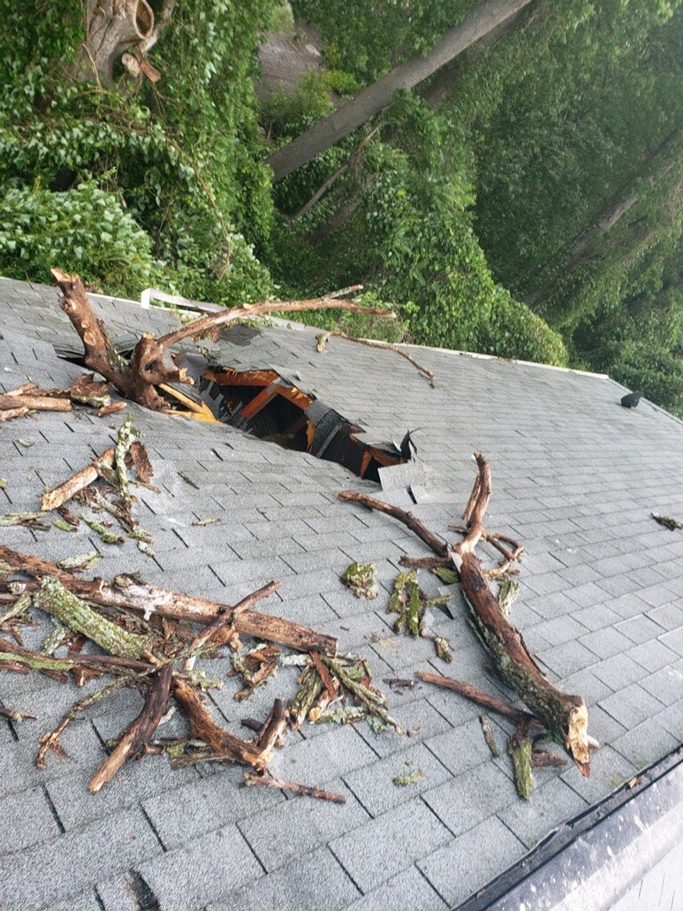
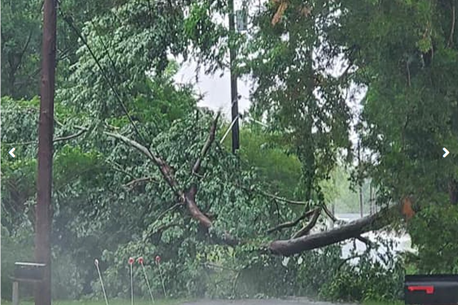
Selected Storm Damage Photos (Credit: NBC 12 Richmond)
 |
 |
 |
 |
| Power Outage Map (credit: poweroutage.us) |
 |
 |
 |
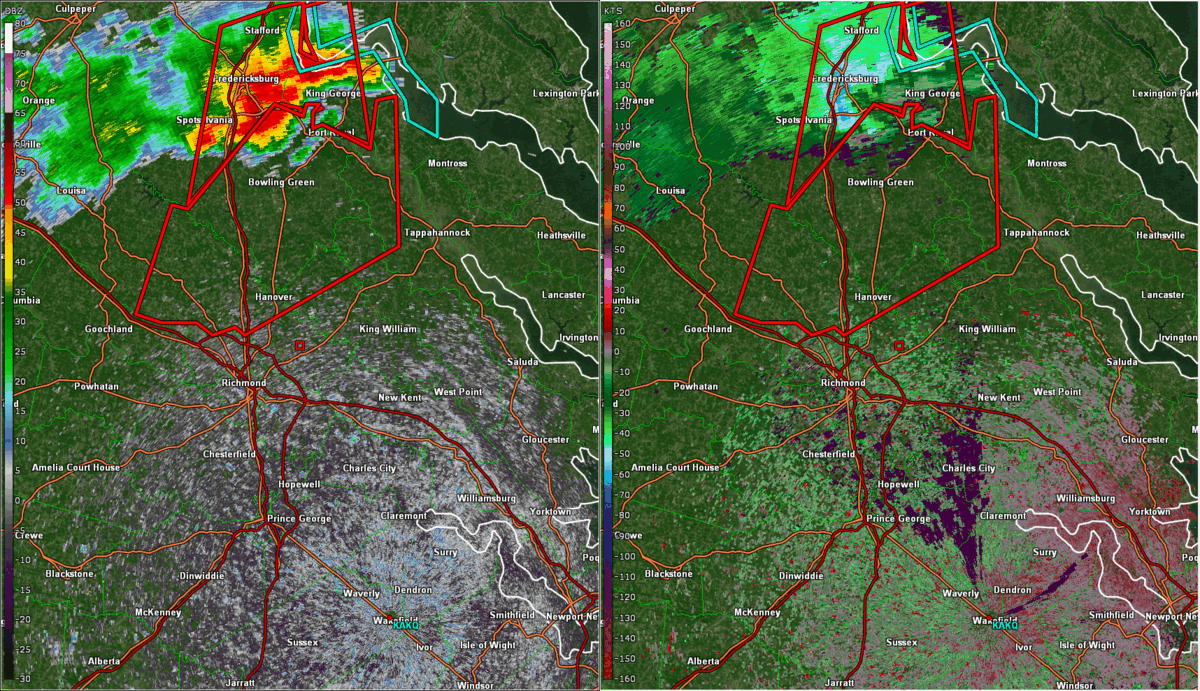
Radar
Radar Loop from 2:30 to 4:40 PM in 10 minute increments
 |
Storm Reports
PRELIMINARY LOCAL STORM REPORT...SUMMARY
NATIONAL WEATHER SERVICE WAKEFIELD VA
804 AM EDT THU JUN 23 2022

..TIME...   ...EVENT...      ...CITY LOCATION...     ...LAT.LON...
..DATE...   ....MAG....      ..COUNTY LOCATION..ST.. ...SOURCE....
            ..REMARKS..

0407 PM     TSTM WND GST     2 NNE REAMS             37.13N 77.39W
06/22/2022  E60 MPH          PRINCE GEORGE      VA   NWS EMPLOYEE

            ESTIMATED WIND GUST OF AT LEAST 50 KNOTS.

0410 PM     TSTM WND DMG     1 SE DISPUTANTA         37.12N 77.21W
06/22/2022                   PRINCE GEORGE      VA   NWS EMPLOYEE

            TREES DOWN ON ROUTE 460.

0310 PM     TSTM WND DMG     1 SSE DUANE FORK        37.85N 77.22W
06/22/2022                   KING WILLIAM       VA   UTILITY COMPANY

            CLUSTER OF NEARLY 1,000 POWER OUTAGES A FEW
            MILES WEST OF BEULAHVILLE. TIME ESTIMATED.

0335 PM     TSTM WND GST     RICHMOND INTERNATIONAL  37.51N 77.32W
06/22/2022  M60 MPH          HENRICO            VA   PUBLIC

            MEASURED 60 MPH GUST AT KRIC.

0315 PM     TSTM WND DMG     1 SE HANOVER            37.75N 77.36W
06/22/2022                   HANOVER            VA   911 CALL CENTER

            NUMEROUS TREES AND WIRES DOWN IN HANOVER
            COURTHOUSE AREA. REPORT FROM NWSCHAT. TIME
            ESTIMATED.

0317 PM     TSTM WND DMG     1 WSW ASHLAND           37.76N 77.49W
06/22/2022                   HANOVER            VA   911 CALL CENTER

            NUMEROUS TREES AND WIRES DOWN IN ASHLAND.
            REPORT FROM NWSCHAT. TIME ESTIMATED.

0318 PM     TSTM WND DMG     1 ESE HANOVER AIRPORT   37.70N 77.43W
06/22/2022                   HANOVER            VA   DEPT OF HIGHWAYS

            MULTIPLE TREES DOWN ON ROADWAY NEAR THE
            INTERSECTION OF NEW ASHCAKE AND SLIDING HILL
            ROAD. TIME ESTIMATED.

0328 PM     TSTM WND DMG     1 WNW MECHANICSVILLE    37.63N 77.38W
06/22/2022                   HANOVER            VA   UTILITY COMPANY

            AROUND 5,000 POWER OUTAGES DUE TO STORM
            BETWEEN MECHANICSVILLE AND STUDLEY. TIME
            ESTIMATED.

0330 PM     TSTM WND DMG     1 SE HANOVER AIRPORT    37.70N 77.43W
06/22/2022                   HANOVER            VA   PUBLIC

            REPORT FROM MPING: 1-INCH TREE LIMBS BROKEN;
            SHINGLES BLOWN OFF.

0331 PM     TSTM WND DMG     1 SSW MECHANICSVILLE    37.61N 77.36W
06/22/2022                   HANOVER            VA   PUBLIC

            REPORT FROM MPING: 1-INCH TREE LIMBS BROKEN;
            SHINGLES BLOWN OFF.

0414 PM     TSTM WND DMG     2 WSW PETERSBURG AIRPOR 37.15N 77.56W
06/22/2022                   DINWIDDIE          VA   UTILITY COMPANY

            NEARLY 2,000 POWER OUTAGES DUE TO STORM.
            THIS LIKELY OCCURRED WITH THE PASSAGE OF THE
            GUST FRONT. TIME ESTIMATED.

0422 PM     TSTM WND DMG     CARSON                  37.03N 77.41W
06/22/2022                   DINWIDDIE          VA   PUBLIC

            OVER 200 POWER OUTAGES DUE TO STORM IN
            CARSON. TIME ESTIMATED FROM RADAR.

0332 PM     TSTM WND DMG     2 N DOWNTOWN RICHMOND   37.56N 77.47W
06/22/2022                   CITY OF RICHMOND   VA   BROADCAST MEDIA

            ROOF RIPPED OFF OF APARTMENT COMPLEX NEAR
            ARTHUR ASHE BLVD AND BROAD ST. TIME
            ESTIMATED.

0332 PM     TSTM WND DMG     2 SSE LAKESIDE          37.58N 77.46W
06/22/2022                   CITY OF RICHMOND   VA   PUBLIC

            REPORT FROM MPING: 3-INCH TREE LIMBS BROKEN;
            POWER POLES BROKEN. TIME ESTIMATED FROM
            RADAR.

0335 PM     TSTM WND DMG     3 ENE DOWNTOWN RICHMOND 37.55N 77.42W
06/22/2022                   CITY OF RICHMOND   VA   911 CALL CENTER

            NUMEROUS TREES AND WIRES DOWN IN THE CITY OF
            RICHMOND. TIME ESTIMATED.

0342 PM     TSTM WND DMG     1 WSW MONTROSE          37.52N 77.40W
06/22/2022                   CITY OF RICHMOND   VA   FIRE DEPT/RESCUE

            TREE FELL AND SMASHED INTO A HOME.

0342 PM     TSTM WND DMG     1 ESE DOWNTOWN RICHMOND 37.52N 77.45W
06/22/2022                   CITY OF RICHMOND   VA   PUBLIC

            TREE DOWN AT THE INTERSECTION OF STONEWALL
            AVE AND W 20TH STREET. TIME ESTIMATED.

0349 PM     TSTM WND DMG     1 ENE RICHMOND          37.48N 77.44W
06/22/2022                   CITY OF RICHMOND   VA   BROADCAST MEDIA

            MULTIPLE TREES DOWN AT RICHMOND HIGHWAY AND
            TERMINAL AVENUE. TIME ESTIMATED FROM RADAR.

0358 PM     TSTM WND DMG     1 ESE ETTRICK           37.23N 77.41W
06/22/2022                   CITY OF PETERSBURG VA   UTILITY COMPANY

            NEARLY 4,000 POWER OUTAGES DUE TO STORM IN
            PETERSBURG. TIME ESTIMATED FROM RADAR.

0415 PM     TSTM WND DMG     3 W PETERSBURG          37.20N 77.44W
06/22/2022                   CITY OF PETERSBURG VA   DEPT OF HIGHWAYS

            TREES DOWN AT MM 60 AND MM 65 ON INTERSTATE
            85. TIME ESTIMATED.

0354 PM     TSTM WND DMG     1 NNE HOPEWELL          37.31N 77.29W
06/22/2022                   CITY OF HOPEWELL   VA   BROADCAST MEDIA

            TREE FELL AND PUNCTURED THE ROOF OF RIVER
            VIEW ON THE APPOMATTOX HEALTH AND REHAB
            CENTER.

0355 PM     TSTM WND DMG     1 SSE COLONIAL HEIGHTS  37.26N 77.39W
06/22/2022                   CITY OF COLONIAL HEVA   PUBLIC

            TREE DOWN BY SOUTHPARK MALL IN COLONIAL
            HEIGHTS. REPORT FROM SOCIAL MEDIA. TIME
            ESTIMATED.

0345 PM     TSTM WND DMG     2 SW RICHMOND           37.46N 77.50W
06/22/2022                   CHESTERFIELD       VA   PUBLIC

            TREE DOWN ON HOME ON SWAN DRIVE. TIME
            ESTIMATED.

0350 PM     TSTM WND DMG     2 SSW RICHMOND          37.45N 77.48W
06/22/2022                   CHESTERFIELD       VA   DEPT OF HIGHWAYS

            TREE DOWN NEAR THE INTERSECTION OF VAUXHALL
            AND SELWOOD ROAD. TIME ESTIMATED.

0354 PM     TSTM WND DMG     3 SE CHESTER            37.32N 77.39W
06/22/2022                   CHESTERFIELD       VA   NWS EMPLOYEE

            NUMEROUS TREES DOWN ON WOODS EDGE ROAD. TIME
            ESTIMATED FROM RADAR.

0354 PM     TSTM WND DMG     1 NE CENTRALIA          37.39N 77.44W
06/22/2022                   CHESTERFIELD       VA   DEPT OF HIGHWAYS

            MULTIPLE TREES DOWN NEAR HOWLETT PARK. TIME
            ESTIMATED.

0354 PM     TSTM WND DMG     1 S BELLWOOD            37.39N 77.44W
06/22/2022                   CHESTERFIELD       VA   PUBLIC

            OVER 1,200 POWER OUTAGES DUE TO STORM JUST
            SOUTH OF BELLWOOD. TIME ESTIMATED.

0357 PM     LIGHTNING        2 SSW MEADOWVILLE       37.34N 77.34W
06/22/2022                   CHESTERFIELD       VA   BROADCAST MEDIA

            BROADCAST MEDIA REPORTED THAT A LIGHTNING
            STRIKE STARTED A HOUSE FIRE ALONG KOYOTO
            COURT.

0240 PM     TSTM WND DMG     1 N WOODFORD            38.13N 77.41W
06/22/2022                   CAROLINE           VA   911 CALL CENTER

            LARGE TREE DOWN ON VEHICLE ON ROZELL ROAD
            ABOUT ONE HALF MILE FROM WOODFORD ROAD.

0240 PM     TSTM WND DMG     VILLBORO                38.13N 77.39W
06/22/2022                   CAROLINE           VA   911 CALL CENTER

            VERY LARGE TREE DOWN BLOCKING THE ENTIRE
            ROAD JUST SOUTH OF THE INTERSECTION OF
            WOODFORD ROAD AND FREDERICKSBURG TURNPIKE.

0240 PM     TSTM WND DMG     GUINEA                  38.14N 77.44W
06/22/2022                   CAROLINE           VA   911 CALL CENTER

            LARGE TREE DOWN ON STONEWALL JACKSON ROAD.

0255 PM     TSTM WND DMG     MILFORD                 38.03N 77.38W
06/22/2022                   CAROLINE           VA   UTILITY COMPANY

            AROUND 1,000 POWER OUTAGES CLUSTERED JUST TO
            THE WEST AND SOUTHWEST OF BOWLING GREEN.
            TIME ESTIMATED FROM RADAR.

0304 PM     TSTM WND DMG     1 SSE GOLANSVILLE       37.97N 77.50W
06/22/2022                   CAROLINE           VA   DEPT OF HIGHWAYS

            DOWNED TREE BLOCKING JEFFERSON DAVIS HIGHWAY
            NEAR HILLCREST DRIVE.


&&

$$
Environment
Synoptic summary.
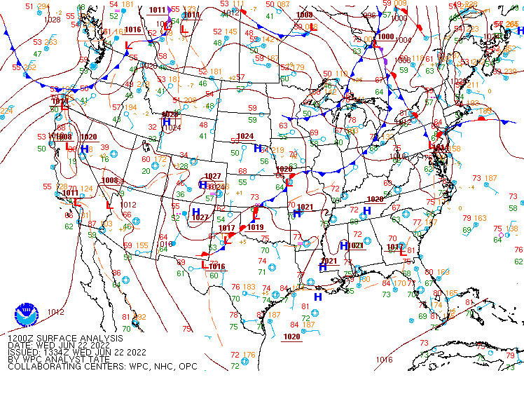 |
| Loop of WPC Surface Analysis |
Near-storm environment summary (Loops from 1 PM to 7 PM)
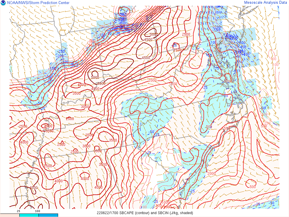 |
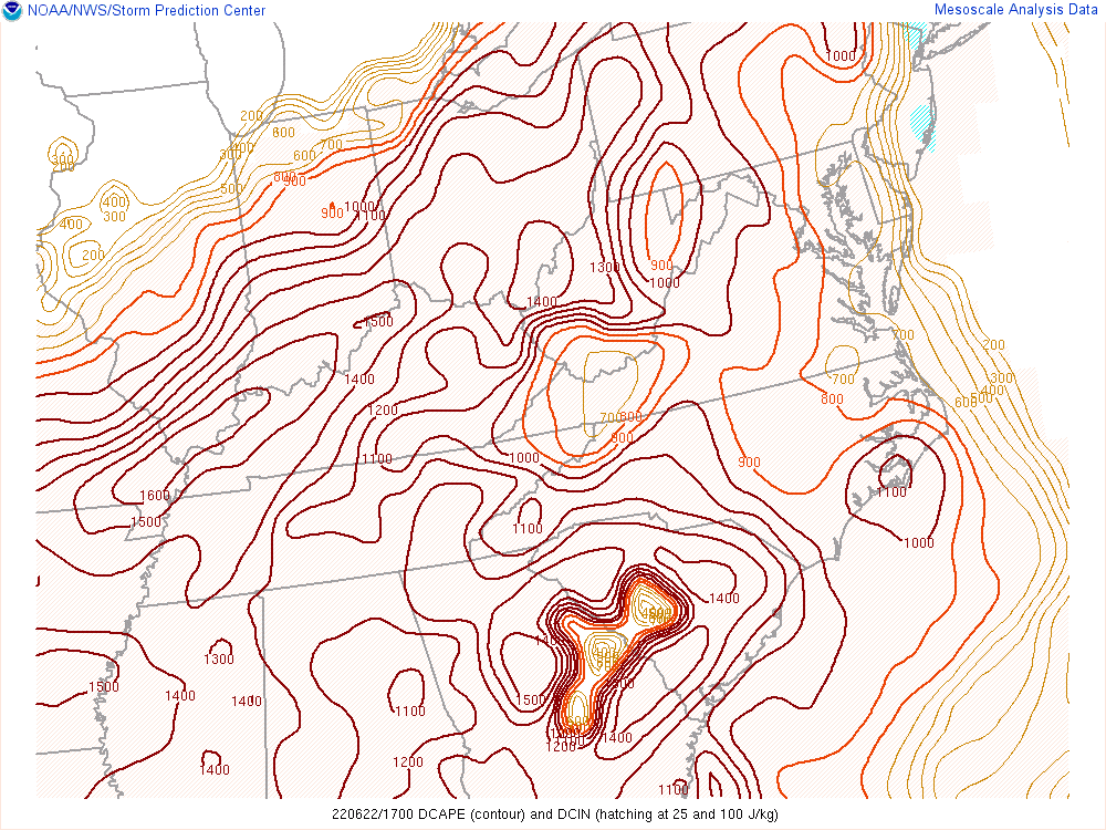 |
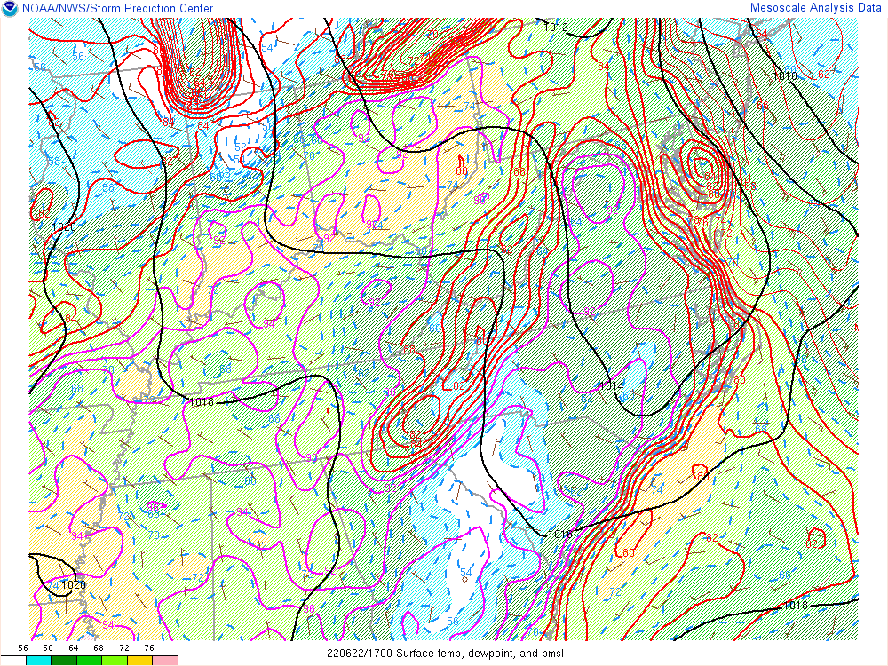 |
| Loop of SBCAPE/CIN | Loop of DCAPE | Loop of Regional Surface Analysis |
Environmental sounding data.
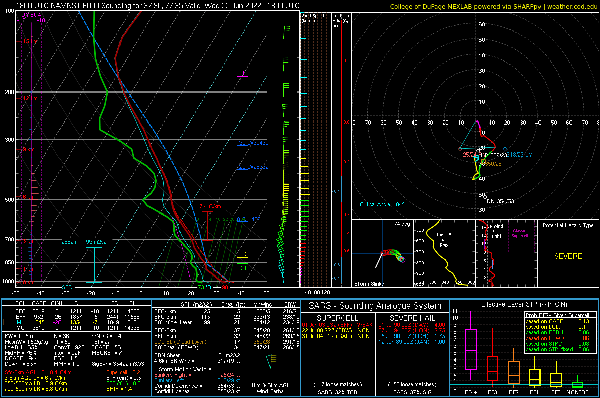 |
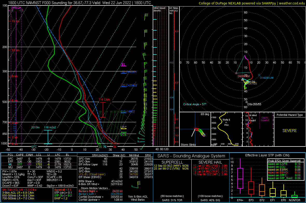 |
| 18z/2 PM NAMNest Analysis Sounding from Caroline County, VA | 18z/2 PM NAMNest Analysis Sounding from just SW of Wakefield, VA |
 |
Media use of NWS Web News Stories is encouraged! Please acknowledge the NWS as the source of any news information accessed from this site. |
|


 Coastal Flood
 Heat
Heat