| State Snow Reports (May contain some Ice Amounts) | WFO Wakefield Snow Reports (May contain some Ice Amounts) |
 |
 |
|
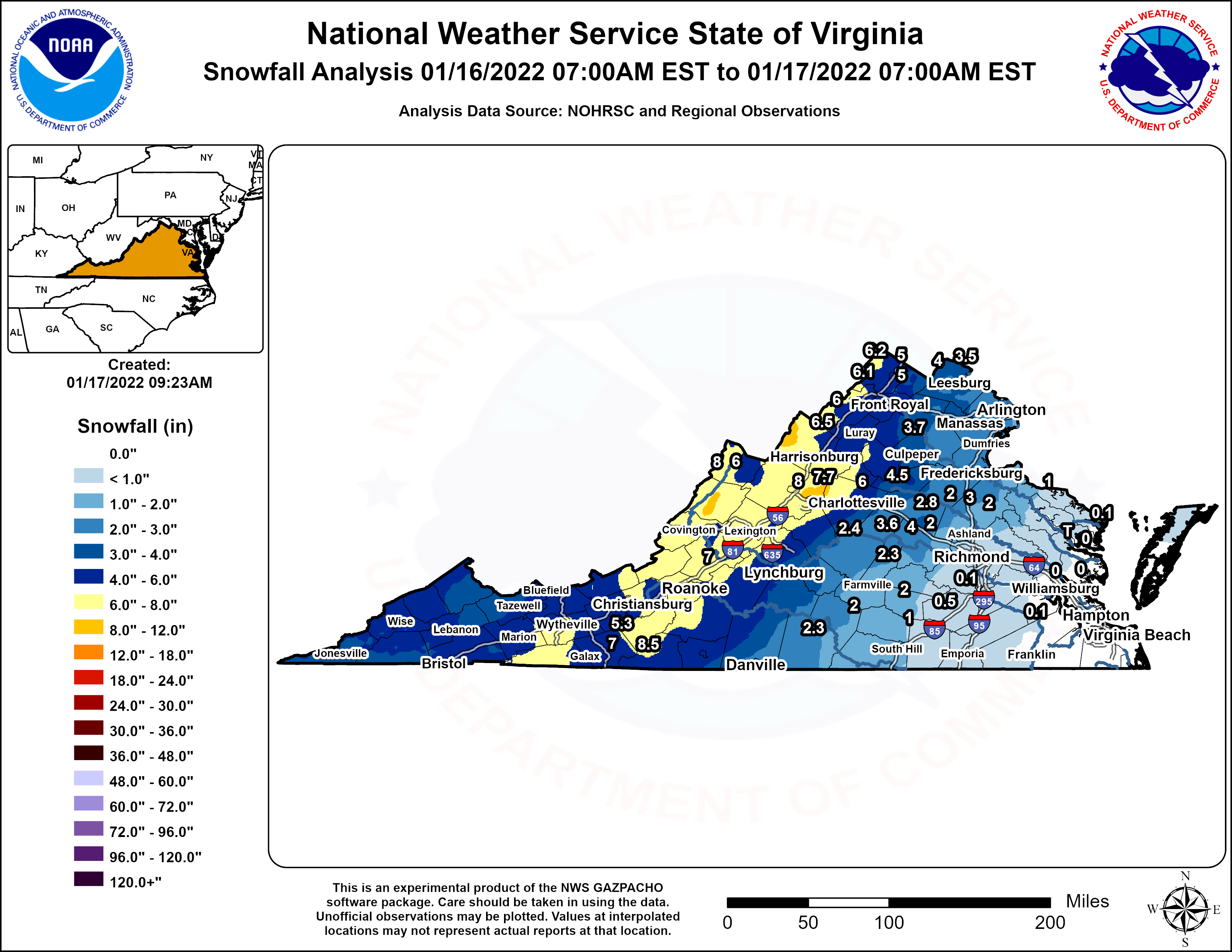
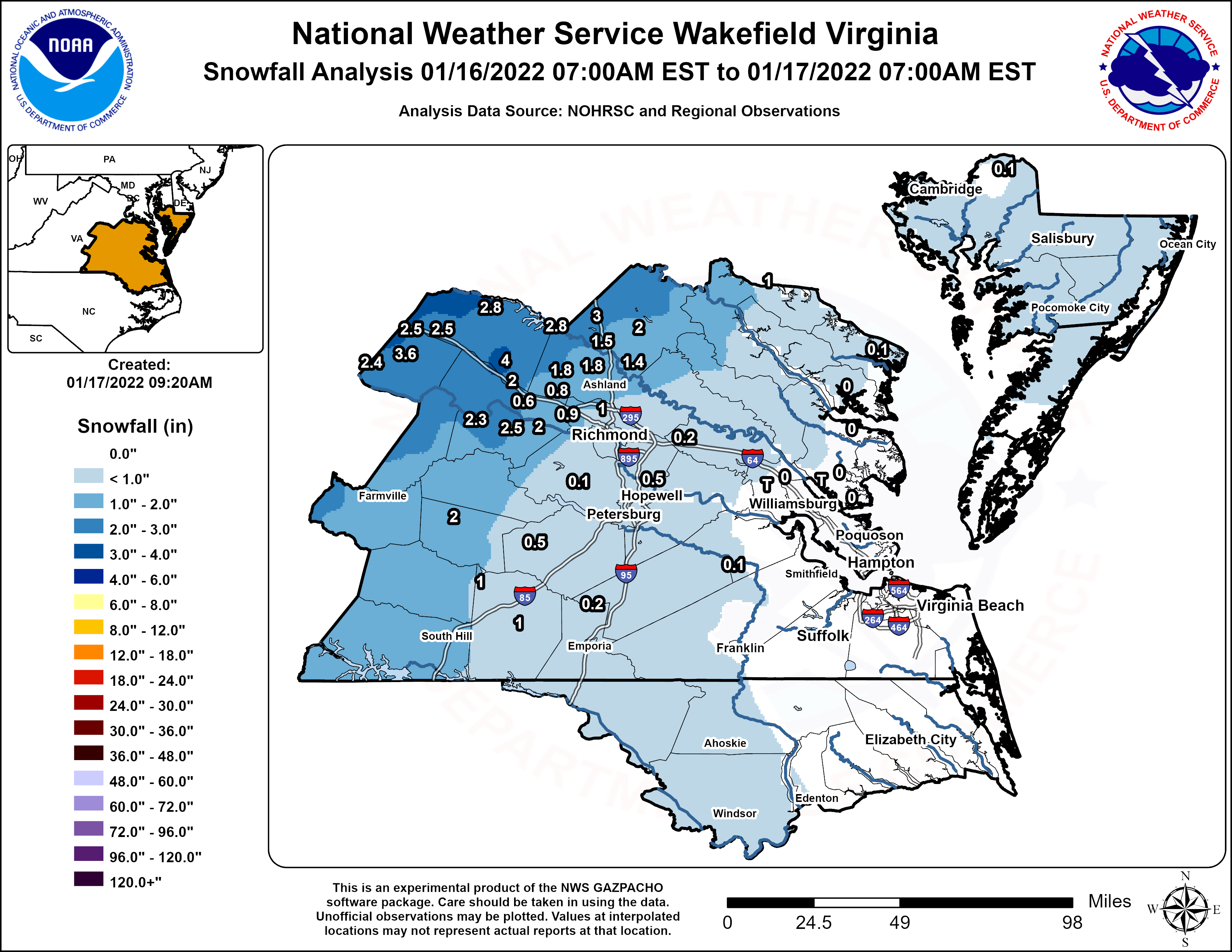
AKQ REPORTS / LWX REPORTS / RNK REPORTS NOUS41 KAKQ 171414 PNSAKQ MDZ021>025-NCZ012>017-030>032-102-VAZ048-060>062-064>069-075>090-092-093- 095>100-509>525-180214- Public Information Statement National Weather Service Wakefield VA 914 AM EST Mon Jan 17 2022 ...SNOWFALL REPORTS... Location Amount Time/Date Provider ...Maryland... ...Dorchester County... 2 ENE East New Market 0.1 in 0413 PM 01/16 Public ...Virginia... ...Brunswick County... Lawrenceville 1.2 SSW 1.0 in 0700 AM 01/17 COCORAHS ...Caroline County... Ruther Glen 3.0 in 0324 PM 01/16 Public Penola 2.0 in 0241 PM 01/16 Public Ruther Glen 1.7 ENE 1.5 in 0700 AM 01/17 COCORAHS 2 S Dawn 1.4 in 0234 PM 01/16 Cocorahs Hanover 3.0 N 1.4 in 0700 AM 01/17 COCORAHS ...Chesterfield County... 1 WSW Meadowville 0.5 in 1205 PM 01/16 NWS Employee Chesterfield 8.5 WSW 0.1 in 0700 AM 01/17 COCORAHS ...City of Norfolk... 1.6 SE Norview T in 1159 PM 01/16 COOP ...City of Richmond... Richmond 4.2 NNE 0.6 in 0700 AM 01/17 COCORAHS ...Dinwiddie County... 1 NNE Darvills 0.5 in 1108 AM 01/16 Public ...Fluvanna County... 3 SW Cunningham 3.6 in 0739 PM 01/16 Public 3 S Antioch 2.4 in 0230 PM 01/16 Public ...Gloucester County... Gloucester Point 0.6 S T in 0700 AM 01/17 COCORAHS Gloucester Courthouse 3.3 SS T in 0800 AM 01/17 COCORAHS ...Greensville County... Purdy 0.3 in 0558 PM 01/16 Trained Spotter ...Hanover County... 1 SW Ashland 2.5 in 0430 PM 01/16 CO-OP Observer 3 NNW Gilman 1.8 in 0435 PM 01/16 Cocorahs Montpelier 4.8 E 1.8 in 0714 AM 01/17 COCORAHS Ashland 1.0 in 0119 PM 01/16 Public 2 S Vontay 0.6 in 0206 PM 01/16 Public ...Henrico County... Tuckahoe 2.0 in 1230 PM 01/16 Public 1 E Longdale 1.0 in 0202 PM 01/16 Trained Spotter Glen Allen 4.6 W 0.9 in 0714 AM 01/17 COCORAHS 3 N Short Pump 0.8 in 0134 PM 01/16 Trained Spotter Chamberlayne 0.7 in 0338 PM 01/16 Public 1 ESE Longdale 0.5 in 1230 PM 01/16 Trained Spotter Richmond 5.3 NW 0.5 in 0700 AM 01/17 COCORAHS Montrose 4.7 SSE 0.2 in 0700 AM 01/17 COCORAHS Sandston 5.9 ESE 0.2 in 0707 AM 01/17 COCORAHS ...James City County... Williamsburg 6.5 NW T in 0700 AM 01/17 COCORAHS ...Lancaster County... Urbanna 6.2 NNE T in 0700 AM 01/17 COCORAHS ...Louisa County... Gum Spring 3.5 NNW 4.0 in 0736 AM 01/17 COCORAHS Bumpass 2.8 in 0317 PM 01/16 Public 1 NNW Louisa 2.8 in 0600 PM 01/16 CO-OP Observer 1 NNE Zion Crossroads 2.5 in 0530 PM 01/16 Cocorahs Gordonsville 10.4 S 2.5 in 0700 AM 01/17 COCORAHS Gum Spring 2.0 in 0824 PM 01/16 Public ...Lunenburg County... Dundas 1.0 in 0207 PM 01/16 NWS Employee ...Middlesex County... Hartfield 2.9 W T in 0700 AM 01/17 COCORAHS ...Northumberland County... Heathsville 4.6 SE 0.1 in 0700 AM 01/17 COCORAHS ...Nottoway County... Crewe 2.0 in 0250 PM 01/16 NWS Employee ...Powhatan County... Powhatan 2.5 in 0120 PM 01/16 Public 1 W Hatchers 2.3 in 0304 PM 01/16 Public Powhatan 7.8 NE 2.0 in 0800 AM 01/17 COCORAHS ...Prince Edward County... Farmville 1.0 SSW 2.1 in 0700 AM 01/17 COCORAHS ...Prince George County... 2 SSE Fort Lee 0.3 in 1200 PM 01/16 NWS Employee ...Sussex County... 1 NW Wakefield 0.1 in 1056 AM 01/16 Official NWS Obs ...Westmoreland County... Stratford 0.5 NE 1.0 in 0740 AM 01/17 COCORAHS ...FREEZING RAIN REPORTS... Location Amount Time/Date Provider ...North Carolina... ...Northampton County... 3 NW Barretts Crossroad 0.10 in 0200 PM 01/16 Public ...Virginia... ...City of Richmond... 3 N Downtown Richmond 0.02 in 0342 PM 01/16 Public ...Henrico County... 3 E Short Pump 0.15 in 0945 PM 01/16 Public Chamberlayne 0.05 in 0337 PM 01/16 Public ...Prince George County... 2 SSE Fort Lee 0.08 in 0220 PM 01/16 NWS Employee && Observations are collected from a variety of sources with varying equipment and exposures. We thank all volunteer weather observers for their dedication. Not all data listed are considered official. $$ NOUS41 KLWX 171405 PNSLWX DCZ001-MDZ001-003>006-008-011-013-014-016>018-501>508-VAZ025>031- 036>040-050>057-501>508-WVZ050>053-055-501>506-180205- Public Information Statement Spotter Reports National Weather Service Baltimore MD/Washington DC 905 AM EST Mon Jan 17 2022 The following are preliminary snow, ice, and wind observations taken during the past 24 hours for the storm that has been affecting our region. Appreciation is extended to cooperative and CoCoRaHS observers, Skywarn spotters and media for these reports. This summary also is available on our home page at weather.gov/lwx. ********************STORM TOTAL SNOWFALL******************** LOCATION TOTAL TIME/DATE COMMENTS SNOWFALL MEASURED (inches) DISTRICT OF COLUMBIA ...District of Columbia... Anacostia SSE 1.5 540 PM 1/16 Trained Spotter MARYLAND ...Allegany County... Cumberland 1 SSE 6.0 700 AM 1/17 Trained Spotter Frostburg 2 ENE 5.5 933 PM 1/16 Trained Spotter Ridgeley 1 NW 5.1 900 PM 1/16 Trained Spotter Cresaptown SSW 4.3 800 PM 1/16 Trained Spotter ...Anne Arundel County... Crownsville 3 SSW 2.0 800 PM 1/16 Trained Spotter Bwi Airport 2.0 700 PM 1/16 Airport Green Haven 1 ESE 2.0 645 PM 1/16 Trained Spotter Odenton 1 WNW 2.0 556 PM 1/16 Trained Spotter Chelsea Beach 1.9 555 PM 1/16 Trained Spotter Odenton 1 S 1.8 620 PM 1/16 Trained Spotter Glen Burnie 1 WSW 1.7 700 PM 1/16 Trained Spotter Churchton ENE 1.0 500 PM 1/16 Trained Spotter ...Baltimore County... Glyndon 1 E 3.0 727 PM 1/16 Trained Spotter Glyndon 1 SW 2.8 725 PM 1/16 Trained Spotter Upper Falls 2 SW 2.8 650 PM 1/16 Trained Spotter Perry Hall 1 NNE 2.7 730 PM 1/16 Trained Spotter Bentley Springs 1 E 2.5 730 PM 1/16 Trained Spotter Kingsville 1 E 2.5 700 AM 1/17 CoCoRaHS Norrisville 3 W 2.4 700 PM 1/16 Trained Spotter Upper Falls 1 NNE 2.4 700 PM 1/16 Trained Spotter Long Green 2 NW 2.3 700 PM 1/16 Trained Spotter Catonsville 1 SSE 2.2 730 PM 1/16 Trained Spotter Edgemere ESE 1.4 612 PM 1/16 Trained Spotter ...Baltimore City... Pimlico SE 2.5 735 PM 1/16 Trained Spotter ...Calvert County... Saint Leonard 1 N 1.8 534 PM 1/16 Trained Spotter Prince Frederick 1 S 1.0 445 PM 1/16 Trained Spotter ...Carroll County... Manchester 1 SSW 3.7 811 AM 1/17 Trained Spotter Millers 4 NE 3.0 1200 AM 1/17 Co-Op Observer Watersville 1 N 3.0 700 PM 1/16 Trained Spotter Mount Airy SE 3.0 700 AM 1/17 CoCoRaHS New Windsor 1 ENE 3.0 700 PM 1/16 NWS Employee Gamber 1 WNW 2.7 716 PM 1/16 CoCoRaHS Eldersburg 1 SE 2.5 650 PM 1/16 Trained Spotter Westminster SE 2.3 700 PM 1/16 Trained Spotter ...Cecil County... Elkton 5 NW 1.5 730 AM 1/17 CoCoRaHS ...Charles County... Waldorf 2 W 1.8 450 PM 1/16 Trained Spotter St. Charles 1 SSE 1.5 519 PM 1/16 CoCoRaHS Dentsville 1 SW 1.3 435 PM 1/16 Trained Spotter Bryantown 2 NE 1.0 700 AM 1/17 CoCoRaHS ...Frederick County... Bloomfield 2 WSW 4.5 1130 PM 1/16 NWS Employee Buckeystown 3 SW 4.1 620 AM 1/17 NWS Employee New Market N 3.5 751 PM 1/16 Trained Spotter Thurmont 3 N 3.4 1110 PM 1/16 NWS Employee Point of Rocks 1 NE 3.2 800 PM 1/16 Trained Spotter Ballenger Creek WSW 3.0 630 PM 1/16 Trained Spotter Adamstown 1 ESE 2.7 940 PM 1/16 NWS Employee Emmitsburg 2 SE 2.0 725 AM 1/17 Co-Op Observer ...Garrett County... Mc Henry 12.0 600 AM 1/17 County Emrg Mgmt Grantsville 5 W 12.0 600 AM 1/17 County Emrg Mgmt Frostburg 3 WNW 12.0 600 AM 1/17 Trained Spotter ...Harford County... Norrisville 1 WSW 3.4 615 AM 1/17 CoCoRaHS Forest Hill 1 NNW 2.8 705 PM 1/16 Trained Spotter Forest Hill 3 SW 2.6 940 PM 1/16 Trained Spotter Bel Air 2 W 2.2 800 PM 1/16 Trained Spotter ...Howard County... Sykesville 2 SSE 3.2 730 AM 1/17 Trained Spotter Columbia 2 N 3.1 700 AM 1/17 CoCoRaHS Columbia 3.0 635 PM 1/16 NWS Employee Columbia 1 ENE 3.0 645 PM 1/16 Trained Spotter Granite 1 SSE 3.0 735 PM 1/16 Trained Spotter Woodstock 2 SW 2.9 700 PM 1/16 Trained Spotter Simpsonville 1 SSE 2.6 800 PM 1/16 Trained Spotter Elkridge 2 W 2.6 620 PM 1/16 Trained Spotter Glenelg 2 N 2.5 900 PM 1/16 Trained Spotter Savage 1 ESE 2.5 645 PM 1/16 Trained Spotter Elkridge 2.5 620 PM 1/16 NWS Employee Roxbury Mills 2 ESE 2.2 630 PM 1/16 Trained Spotter Columbia 2 NE 2.1 600 PM 1/16 Trained Spotter Ellicott City 2.0 655 PM 1/16 Broadcast Media ...Montgomery County... Clarksburg 1 SSE 3.8 1200 AM 1/17 CoCoRaHS Damascus 3 SSW 3.5 809 AM 1/17 Co-Op Observer Damascus 1 S 3.3 636 PM 1/16 Trained Spotter Poolesville NE 3.0 715 PM 1/16 Trained Spotter Garrett Park 1 ENE 3.0 600 PM 1/16 Trained Spotter Boyds 1 N 3.0 620 PM 1/16 County Emrg Mgmt Germantown 3.0 600 PM 1/16 County Emrg Mgmt Damascus 1 SE 3.0 630 PM 1/16 Trained Spotter Potomac 1 NNW 3.0 700 AM 1/17 CoCoRaHS Laytonsville 5 NNW 3.0 630 PM 1/16 CoCoRaHS Germantown 2 WSW 3.0 900 PM 1/16 Trained Spotter Montgomery Village 1 2.9 630 AM 1/17 CoCoRaHS Norbeck 1 ESE 2.9 700 AM 1/17 CoCoRaHS Boyds 1 SE 2.8 600 PM 1/16 Trained Spotter Colesville 2 W 2.6 700 AM 1/17 CoCoRaHS Bethesda 1 WSW 2.5 556 PM 1/16 Trained Spotter Gaithersburg 3 NE 2.5 600 PM 1/16 CoCoRaHS Rockville 3 E 2.5 600 PM 1/16 CoCoRaHS Montgomery Village 1 2.5 558 PM 1/16 Trained Spotter Colesville 2.5 550 PM 1/16 Trained Spotter Laytonsville 2 WNW 2.5 729 PM 1/16 Trained Spotter Kensington 2.4 545 PM 1/16 CoCoRaHS North Potomac 4 N 2.3 630 AM 1/17 CoCoRaHS Takoma Park 1 NNW 2.3 700 AM 1/17 CoCoRaHS Bethesda 1 NNW 2.2 555 PM 1/16 Trained Spotter Somerset 1 ENE 2.1 615 PM 1/16 Trained Spotter Silver Spring 6 NNE 2.1 437 AM 1/17 CoCoRaHS Montgomery Village 1 1.7 542 PM 1/16 CoCoRaHS Aspen Hill 2 ENE 1.4 520 PM 1/16 CoCoRaHS ...Prince Georges County... Greenbelt 1 N 2.0 700 AM 1/17 CoCoRaHS Marlton 1 WSW 2.0 500 PM 1/16 Trained Spotter Fort Washington 1 SS 2.0 700 AM 1/17 CoCoRaHS Capitol Heights 2.0 600 PM 1/16 Trained Spotter ...St. Marys County... Mechanicsville 4 N 1.0 606 AM 1/17 CoCoRaHS Leonardtown 1 NE 1.0 600 AM 1/17 CoCoRaHS Callaway 2 W 0.9 408 PM 1/16 Trained Spotter Mechanicsville 7 SE 0.8 700 AM 1/17 CoCoRaHS California 3 W 0.6 531 PM 1/16 Trained Spotter Hollywood 3 S 0.5 308 PM 1/16 Trained Spotter Ridge 1 N 0.2 700 AM 1/17 CoCoRaHS ...Washington County... Boonsboro 3 NNE 3.3 630 AM 1/17 Trained Spotter Hancock 1 ESE 3.0 630 PM 1/16 Trained Spotter Hagerstown 1 NNE 2.5 715 PM 1/16 Trained Spotter Williamsport 3 ENE 2.0 600 AM 1/17 CoCoRaHS Hagerstown 1 ENE 1.9 700 AM 1/17 CoCoRaHS VIRGINIA ...Albemarle County... Ivy 8.0 1045 PM 1/16 Trained Spotter Earlysville 3 NW 6.0 1000 PM 1/16 Trained Spotter Earlysville 2 WNW 5.0 600 PM 1/16 Trained Spotter Boyd Tavern 1 S 4.0 830 PM 1/16 Trained Spotter ...Arlington County... Reagan National Apt 2.6 700 PM 1/16 Airport Falls Church 1 E 2.3 700 PM 1/16 Trained Spotter Baileys Crossroads 1 2.1 512 PM 1/16 Trained Spotter Rosslyn 1 S 1.9 600 PM 1/16 Trained Spotter ...Augusta County... Fishersville 1 NE 9.0 600 AM 1/17 Trained Spotter Weyers Cave 1 SSW 7.7 745 AM 1/17 Trained Spotter Waynesboro 1 S 7.0 533 PM 1/16 Trained Spotter ...City of Alexandria... Alexandria 1 W 2.1 515 PM 1/16 Trained Spotter Lincolnia 2 S 2.0 510 PM 1/16 Trained Spotter Alexandria 1 ENE 1.8 500 PM 1/16 Trained Spotter ...City of Charlottesville... Charlottesville 1 ES 4.2 700 AM 1/17 Trained Spotter Newcomb Hall 1 SW 4.0 420 PM 1/16 Trained Spotter Charlottesville 1 NN 3.4 435 PM 1/16 Trained Spotter ...City of Falls Church... Lake Barcroft 1 W 2.2 510 PM 1/16 Trained Spotter ...City of Fredericksburg... Fredericksburg 1 SSW 2.1 811 PM 1/16 Trained Spotter ...City of Harrisonburg... Harrisonburg 2 W 7.0 612 AM 1/17 Broadcast Media ...City of Manassas... Manassas Park 1 SW 3.2 543 PM 1/16 Trained Spotter Manassas 3 SSW 2.2 630 PM 1/16 Trained Spotter ...City of Staunton... Staunton 1 WSW 8.0 700 AM 1/17 CoCoRaHS ...City of Winchester... Winchester 1 NNE 5.0 700 PM 1/16 Trained Spotter ...Clarke County... Berryville 1 NNW 5.3 1035 PM 1/16 Trained Spotter Inwood 2 E 4.2 915 PM 1/16 Trained Spotter Stringtown 2 WSW 4.0 730 PM 1/16 Trained Spotter ...Culpeper County... Culpeper 1 W 3.8 700 PM 1/16 Trained Spotter Rixeyville 3 N 3.7 700 AM 1/17 CoCoRaHS Richardsville 1 WSW 3.2 839 PM 1/16 Trained Spotter Cardova 2 SSE 3.1 530 PM 1/16 CoCoRaHS ...Fairfax County... Herndon 3 S 3.1 700 AM 1/17 CoCoRaHS Chantilly 3 SE 3.0 1013 PM 1/16 Trained Spotter Reston 2 N 2.8 600 PM 1/16 Trained Spotter Chantilly 2 ESE 2.7 555 PM 1/16 Trained Spotter Herndon 2 ENE 2.5 600 PM 1/16 Trained Spotter Chantilly 2 ENE 2.5 545 PM 1/16 Trained Spotter Vienna 3 N 2.5 700 AM 1/17 CoCoRaHS Mount Vernon NW 2.5 700 AM 1/17 CoCoRaHS Centreville W 2.5 610 PM 1/16 Trained Spotter Herndon 1 NNE 2.4 540 PM 1/16 NWS Employee Fairfax Station 1 SE 2.3 520 PM 1/16 Trained Spotter Langley 1 SE 2.3 520 PM 1/16 Trained Spotter Franconia 1 SSW 2.3 500 PM 1/16 Trained Spotter Sterling Park 2 ENE 2.0 753 PM 1/16 Trained Spotter Alexandria 6 SSW 2.0 700 AM 1/17 CoCoRaHS Annandale 2 W 2.0 500 AM 1/17 CoCoRaHS ...Fauquier County... Opal 3.0 505 PM 1/16 NWS Employee Remington 4 ENE 3.0 700 AM 1/17 CoCoRaHS Broken Hill 2 E 3.0 705 PM 1/16 NWS Employee Warrenton 3 SE 2.0 700 AM 1/17 CoCoRaHS ...Frederick County... Cross Junction 1 WSW 6.2 742 AM 1/17 Trained Spotter Hayfield 1 N 6.1 808 PM 1/16 Trained Spotter Stephens City 2 E 5.3 1200 AM 1/17 CoCoRaHS Cedar Grove 2 ENE 5.0 740 PM 1/16 Trained Spotter Albin 2 SE 5.0 750 PM 1/16 Trained Spotter Nineveh 2 NNE 4.5 755 PM 1/16 Trained Spotter ...Greene County... Quinque 2 WSW 3.5 515 PM 1/16 Trained Spotter ...Highland County... Mill Gap 1 SW 8.0 600 AM 1/17 Co-Op Observer Monterey 7 SSW 6.0 700 AM 1/17 CoCoRaHS ...King George County... King George 1 NE 2.0 500 PM 1/16 Trained Spotter ...Loudoun County... Hillsboro 3 NW 4.0 1100 PM 1/16 Trained Spotter Ashburn N 3.5 700 PM 1/16 Trained Spotter Lovettsville 3.5 804 PM 1/16 County Emrg Mgmt Arcola 3 S 3.5 600 PM 1/16 Trained Spotter Leesburg 3 E 3.5 745 AM 1/17 CoCoRaHS Ashburn 3 WSW 3.5 730 PM 1/16 NWS Employee Dulles International 3.1 600 PM 1/16 Trained Spotter Purcellville 2 E 3.0 713 PM 1/16 NWS Employee Countryside 1 W 3.0 700 PM 1/16 Trained Spotter Purcellville 2.8 1030 PM 1/16 NWS Employee Belmont 2 NNE 2.8 625 PM 1/16 Trained Spotter Dulles International 2.5 700 AM 1/17 Airport ...Madison County... Madison 7 NNW 5.0 630 AM 1/17 CoCoRaHS Madison 2 ENE 4.5 705 PM 1/16 Trained Spotter ...Orange County... Lahore 2 NW 4.5 845 PM 1/16 Trained Spotter Barboursville 3.8 500 PM 1/16 CoCoRaHS ...Page County... Ida 1 SW 8.0 919 PM 1/16 Trained Spotter Rileyville 1 W 6.2 905 PM 1/16 Trained Spotter Honeyville 1 ESE 6.0 730 AM 1/17 Trained Spotter ...Prince William County... Manassas Park 1 NNW 3.4 550 PM 1/16 Trained Spotter Woolsey 1 SW 3.2 730 PM 1/16 Trained Spotter Manassas 6 SE 2.8 530 AM 1/17 CoCoRaHS Dumfries 1 ENE 2.8 445 PM 1/16 Trained Spotter Independent Hill 3 N 2.7 515 PM 1/16 Trained Spotter Manassas 5 SE 2.7 600 AM 1/17 CoCoRaHS Dale City 1 W 2.5 500 PM 1/16 Trained Spotter Manassas 2.3 500 PM 1/16 County Emrg Mgmt ...Rockingham County... Timberville 3 NW 6.5 730 AM 1/17 Trained Spotter Massanutten 1 SE 6.5 700 AM 1/17 CoCoRaHS Bridgewater 2 E 5.5 200 AM 1/17 Trained Spotter Harrisonburg 9 NE 5.5 700 AM 1/17 CoCoRaHS ...Shenandoah County... Harmony 3 W 6.0 745 PM 1/16 Trained Spotter Strasburg 4 N 5.5 700 AM 1/17 CoCoRaHS Toms Brook 3 SSE 5.5 800 PM 1/16 Trained Spotter ...Spotsylvania County... Fredericksburg 5 SSW 3.0 500 AM 1/17 CoCoRaHS White Oak 4 SSW 2.8 445 PM 1/16 Trained Spotter White Oak 5 SSW 2.5 426 PM 1/16 Trained Spotter Spotsylvania Courtho 2.0 456 PM 1/16 Trained Spotter Chancellorsville 2 N 2.0 332 PM 1/16 Trained Spotter Chancellorsville 3 S 1.5 325 PM 1/16 Trained Spotter ...Stafford County... Holly Corner 1 ENE 2.9 514 PM 1/16 NWS Employee Aquia 1 NE 2.8 451 PM 1/16 Trained Spotter Glendie 2 SSE 2.6 410 PM 1/16 Trained Spotter White Oak 3 SSE 2.0 517 PM 1/16 CoCoRaHS Fredericksburg 8 ESE 1.8 700 AM 1/17 CoCoRaHS ...Warren County... Karo 1 WSW 7.2 730 AM 1/17 Trained Spotter Riverton 1 WNW 4.8 645 PM 1/16 Trained Spotter WEST VIRGINIA ...Berkeley County... Martinsburg 2 E 4.0 1000 PM 1/16 NWS Employee Bunker Hill SE 3.5 711 PM 1/16 Trained Spotter ...Grant County... Petersburg 8.5 700 AM 1/17 Co-Op Observer ...Hampshire County... Capon Bridge 5 SW 6.0 630 AM 1/17 Trained Spotter ...Hardy County... Rig NW 8.0 700 AM 1/17 CoCoRaHS Wardensville 3 E 7.0 815 PM 1/16 Trained Spotter Rig NNW 5.0 720 PM 1/16 Trained Spotter ...Jefferson County... Bloomery 3 SSE 3.7 705 PM 1/16 Trained Spotter Millville 1 ESE 3.6 743 PM 1/16 Trained Spotter ...Mineral County... Keyser 6.3 900 PM 1/16 Trained Spotter Burlington E 5.7 930 PM 1/16 Trained Spotter ...Morgan County... Berkeley Spgs 1 E 6.0 730 AM 1/17 Trained Spotter ...Pendleton County... Deer Run 2 WSW 10.0 545 AM 1/17 Storm total **********************STORM TOTAL ICE*********************** LOCATION TOTAL TIME/DATE COMMENTS ICE MEASURED (inches) MARYLAND ...Anne Arundel County... Odenton 1 WNW 0.06 859 PM 1/16 Trained Spotter Green Haven 1 ESE 0.06 645 PM 1/16 Trained Spotter Crownsville 3 SSW 0.05 800 PM 1/16 Trained Spotter ...Carroll County... Watersville 1 N 0.05 1000 PM 1/16 Trained Spotter ...Frederick County... Thurmont 3 N 0.30 1110 PM 1/16 NWS Employee Bloomfield 2 WSW 0.25 1130 PM 1/16 NWS Employee Adamstown 1 ESE 0.25 1055 PM 1/16 NWS Employee Buckeystown 3 SW 0.25 620 AM 1/17 NWS Employee Ballenger Creek WSW 0.13 1010 PM 1/16 Trained Spotter Point of Rocks 1 NE 0.05 800 PM 1/16 Trained Spotter ...Garrett County... Mc Henry T 600 AM 1/17 County Emrg Mgmt ...Harford County... Forest Hill 3 SW 0.05 940 PM 1/16 Trained Spotter ...Howard County... Granite 1 SSE 0.13 735 PM 1/16 Trained Spotter Columbia 2 N T 700 PM 1/16 Trained Spotter Savage 1 ESE T 645 PM 1/16 Trained Spotter ...Montgomery County... Germantown 2 WSW 0.04 900 PM 1/16 Trained Spotter VIRGINIA ...Albemarle County... Boyd Tavern 1 S T 830 PM 1/16 Trained Spotter ...Arlington County... Falls Church 1 E 0.07 730 PM 1/16 Trained Spotter ...City of Charlottesville... Charlottesville 1 ES 0.08 700 AM 1/17 Trained Spotter ...City of Fredericksburg... Fredericksburg 1 SSW T 811 PM 1/16 Trained Spotter ...Culpeper County... Richardsville 1 WSW 0.20 839 PM 1/16 Trained Spotter Rixeyville 1 W 0.10 1205 AM 1/17 Trained Spotter ...Frederick County... Nineveh 2 NNE T 755 PM 1/16 Trained Spotter ...Loudoun County... Ashburn 3 WSW 0.13 730 PM 1/16 NWS Employee Purcellville 0.10 1030 PM 1/16 NWS Employee Ashburn N 0.07 700 PM 1/16 Trained Spotter Dulles International 0.06 830 PM 1/16 NWS Office Leesburg 1 ESE 0.05 830 PM 1/16 NWS Employee ...Prince William County... Woolsey 1 SW 0.13 935 PM 1/16 Trained Spotter ...Stafford County... Aquia 1 NE T 451 PM 1/16 Trained Spotter ...Warren County... Riverton 1 WNW 0.19 810 PM 1/16 Trained Spotter Karo 1 WSW 0.06 730 AM 1/17 Trained Spotter WEST VIRGINIA ...Jefferson County... Bloomery 3 SSE 0.12 700 AM 1/17 Trained Spotter ***********************PEAK WIND GUST*********************** LOCATION MAX WIND TIME/DATE COMMENTS GUST MEASURED (mph) MARYLAND ...ANZ532... Bay Ridge 1 NNE 54 706 PM 1/16 NDBC ...ANZ533... Taylors Island 8 NW 49 430 AM 1/17 NDBC ...ANZ536... Potomac Lt 33 46 1222 AM 1/17 WXFLOW ...ANZ537... Hull Neck 5 NNE 56 930 PM 1/16 NDBC ...ANZ538... Dundalk 3 SSW 55 1100 PM 1/16 NDBC ...ANZ543... Crisfield 52 950 PM 1/16 WXFLOW Bishops Head; MD 48 942 PM 1/16 NOS-NWLON Lower Hooper Island 48 909 PM 1/16 WXFLOW ...Carroll County... Westminster 2 N 49 1235 AM 1/17 AWOS ...Charles County... Cuckold Creek 46 1028 PM 1/16 WXFLOW ...St. Marys County... Patuxent River NAS 47 954 PM 1/16 AWOS ...Washington County... Hagerstown Rgnl Arpt 49 1122 PM 1/16 ASOS Boonsboro 46 1133 PM 1/16 CWOP VIRGINIA ...Fairfax County... Dulles Intl Airport 58 1036 PM 1/16 ASOS Centreville 55 1156 PM 1/16 CWOP NOUS41 KRNK 170304 PNSRNK NCZ001>006-018>020-VAZ007-009>020-022>024-032>035-043>047-058-059-WVZ042>044- 507-508-171504- Public Information Statement National Weather Service Blacksburg VA 1004 PM EST Sun Jan 16 2022 Here are the latest snowfall, sleet, and freezing rain totals we received at our office between 8pm and 10pm. ...SNOWFALL REPORTS... Location Amount Time/Date Lat/Lon ...North Carolina... ...Caswell County... 4 ESE Quick 1.0 in 0930 PM 01/16 36.37N/79.43W ...Rockingham County... 3 SW Lawsonville 2.0 in 1130 AM 01/16 36.37N/79.61W ...Stokes County... 2 NW Lawsonville 7.0 in 0830 PM 01/16 36.50N/80.28W ...Surry County... 4 N Bottom 3.3 in 0745 PM 01/16 36.53N/80.77W ...Wilkes County... 2 NE Maple Springs 7.4 in 0821 PM 01/16 36.21N/81.36W 2 NNW Benham 4.8 in 0800 PM 01/16 36.32N/80.93W ...Virginia... ...Appomattox County... Appomattox 4.0 in 0920 PM 01/16 37.36N/78.83W ...Bedford County... Stewartsville 6.2 in 0910 PM 01/16 37.27N/79.80W 2 W Goodview 6.2 in 0920 PM 01/16 37.22N/79.76W 3 ENE Vinton 5.5 in 0821 PM 01/16 37.29N/79.85W ...Bland County... Bland 5.0 in 0900 PM 01/16 37.11N/81.11W ...Botetourt County... 2 SSW Fincastle 7.0 in 0811 PM 01/16 37.47N/79.89W ...Carroll County... 3 ESE Gladesboro 7.0 in 0938 PM 01/16 36.70N/80.61W 2 SSE Byllesby 4.0 in 0900 PM 01/16 36.75N/80.92W ...Charlotte County... 3 WSW Abilene 2.0 in 0600 PM 01/16 37.12N/78.59W ...City of Lynchburg... 1 WSW Lynchburg City 3.5 in 0833 PM 01/16 37.41N/79.17W ...City of Roanoke... 2 S Roanoke Airport 7.1 in 0912 PM 01/16 37.31N/79.98W ...Floyd County... Willis 8.5 in 0836 PM 01/16 36.85N/80.48W ...Halifax County... 6 W Crystal Hill 2.3 in 0955 PM 01/16 36.84N/79.00W ...Pulaski County... Graysontown 5.3 in 0606 PM 01/16 37.05N/80.57W ...Roanoke County... 2 SE Cave Spring 8.0 in 0910 PM 01/16 37.21N/79.99W ...Wythe County... 3 SSW Wytheville 7.0 in 0942 PM 01/16 36.91N/81.10W ...SLEET REPORTS... Location Amount Time/Date Lat/Lon ...North Carolina... ...Caswell County... 4 ESE Quick 1.8 in 0941 PM 01/16 36.37N/79.43W ...Rockingham County... 3 SW Lawsonville 1.0 in 0600 PM 01/16 36.37N/79.61W ...Virginia... ...Bedford County... Stewartsville 1.0 in 0910 PM 01/16 37.27N/79.80W ...Bland County... Bland 0.3 in 0900 PM 01/16 37.11N/81.11W ...Carroll County... 2 SSE Byllesby 2.3 in 0920 PM 01/16 36.75N/80.92W ...FREEZING RAIN REPORTS... Location Amount Time/Date Lat/Lon ...North Carolina... ...Caswell County... 4 ESE Quick 0.10 in 0930 PM 01/16 36.37N/79.43W ...Rockingham County... 3 SW Lawsonville 0.01 in 0700 PM 01/16 36.37N/79.61W && Observations are collected from a variety of sources with varying equipment and exposures. We thank all volunteer weather observers for their dedication. Not all data listed are considered official. $$
|
|


 Coastal Flood
 Heat
Heat