Overview
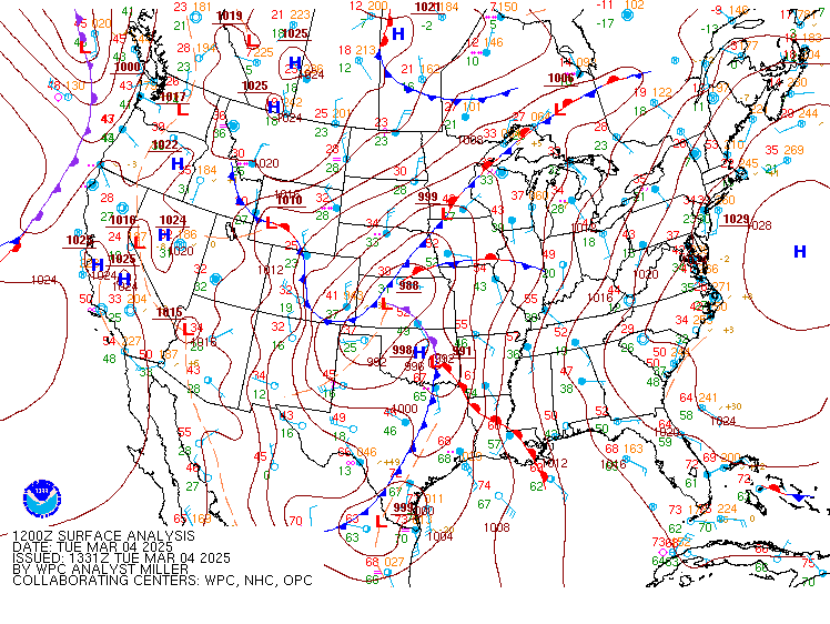
After an active past two months of winter weather, we saw our most impactful severe weather event of 2025 so far on March 5th. A very strong (~980mb) area of low pressure tracked well to the northwest of the area during the day while a seasonably strong cold front approached from the west. Ahead of the front, southerly flow increased with gradient winds of 20-35 mph with gusts of 40-50 mph common by late morning. Meanwhile, ongoing convection (well ahead of the front) started to enter western portions of the Wakefield CWA by late morning. Dew points were still in the mid to upper 50s (with temperatures in the 60s) during the late morning, and any surface-based instability was still to our south. However, the kinematic fields were very strong, with 60-80 knots of wind just a few thousand feet above the surface. While sporadic wind damage was observed from the Piedmont to I-95 Corridor, the storms really picked up in intensity during the afternoon when they moved into SE VA. By this time, dew points had risen to near 60°F, and there were a couple hundred J/kg of surface-based CAPE present in the SE.
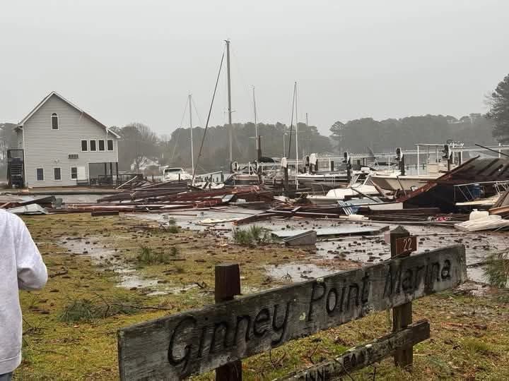
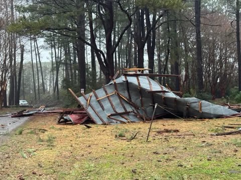
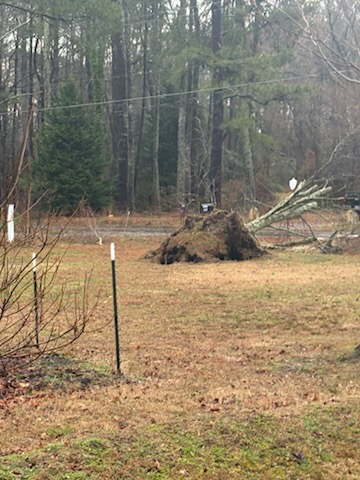
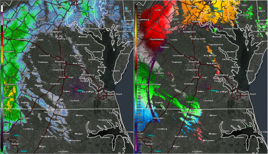
Storms started to show rotation as the approached the NWS Wakefield office, and a Tornado Warning was issued for the office itself! While no tornadoes touched down as the storms passed through interior portions of SE VA and NE NC, more widespread severe wind gusts were observed as the storms tracked through Southampton, Surry, Sussex, and Isle of Wight Counties. In fact, a wind gust of 45 knots/52 mph was recorded at the Wakefield (KAKQ) ASOS! The storms reached peak intensity as they tracked across northern portions of Hampton Roads and especially the Middle Peninsula. Widespread severe wind gusts were observed with extensive tree damage and even some structural damage reported. In fact, the thunderstorm winds (likely in the 70-80 mph range based on the NWS Storm Survey) collapsed a boat house at Ginney Point Marina in Mathews County. The other area that saw the worst of the damage was in Gloucester County, where several trees were downed with one large tree falling on a house. In addition to the wind damage, a waterspout formed on the York River and briefly came onshore as a tornado in southwest Gloucester County. The tornado downed trees and damaged a home near Allmondsville before lifting. Peak winds of 75-85 mph were estimated in the tornado, which was rated EF-0.
Tornado:
|
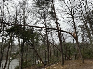
Tornado - Allmondsville
Track Map 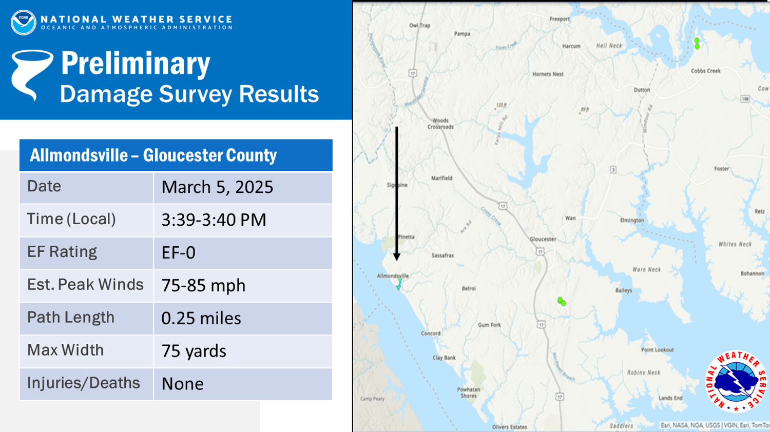 
|
||||||||||||||||
The Enhanced Fujita (EF) Scale classifies tornadoes into the following categories:
| EF0 Weak 65-85 mph |
EF1 Moderate 86-110 mph |
EF2 Significant 111-135 mph |
EF3 Severe 136-165 mph |
EF4 Extreme 166-200 mph |
EF5 Catastrophic 200+ mph |
 |
|||||
Photos
Storm Damage Photos from Gloucester/Mathews Counties
 |
 |
 |
 |
| Cobbs Creek Damage | Cobbs Creek Damage | Gloucester County Damage | Gloucester County Damage |
Radar
Selected Radar Loops
 |
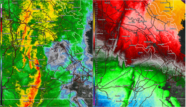 |
| Loop of 0.5° Reflectivity (left) and Base Velocity (right) from 10 AM to 5 PM in ~30 minute increments. Note that Local Storm Reports are overlaid. | Zoomed in Loop of 0.5° Reflectivity (left) and Base Velocity (right) from 3 PM to 4 PM in 1-2 minute increments. |
Storm Reports
1155 AM     Tstm Wnd Dmg     2 S Rubermount          37.04N 78.21W
03/05/2025                   Lunenburg          VA   Dept of Highways

            Tree down on Rt. 723 in the vicinity of
            Rubermont Rd north of Victoria. Time
            estimated.
1152 AM     Tstm Wnd Dmg     2 NW Chula              37.41N 77.93W
03/05/2025                   Amelia             VA   Dept of Highways

            Tree down on Route 633 in the vicinity of
            Dykeland Rd northwest of Chula. Time
            estimated.
1227 PM     Tstm Wnd Gst     1 NNE Longdale          37.67N 77.46W
03/05/2025  E60 MPH          Henrico            VA   Trained Spotter

            Trained spotter estimated 50-60 mph wind
            gusts. Some outdoor furniture was overturned
            by the wind.
1235 PM     Tstm Wnd Dmg     1 ENE Mechanicsville    37.63N 77.34W
03/05/2025                   Hanover            VA   Dept of Highways

            Power lines down on Route 643 in the
            vicinity of Brooks Hollow Park near
            Mechanicsville. Time estimated.
0105 PM     Tstm Wnd Dmg     Westwood                37.60N 77.18W
03/05/2025                   Hanover            VA   Dept of Highways

            Tree down on Route 619 in the vicinity of
            Flannigan Mill Rd just west of the
            Hanover/New Kent county line. Time
            estimated.
1227 PM     Tstm Wnd Dmg     2 WNW Dumbarton         37.61N 77.53W
03/05/2025                   Henrico            VA   Broadcast Media

            Large tree down near the intersection of
            Biscayne and Capehart Rd. Time estimated.
0245 PM     Tstm Wnd Dmg     2 NNW Worrell           36.75N 77.23W
03/05/2025                   Southampton        VA   911 Call Center

            Tree down on Brandy Pond Road near Capron.
            Time estimated.
0256 PM     Tstm Wnd Dmg     1 W Boykins             36.58N 77.22W
03/05/2025                   Southampton        VA   911 Call Center

            Multiple trees down in Branchville and
            Boykins. Time estimated.
0300 PM     Tstm Wnd Dmg     1 NNW Courtland         36.72N 77.07W
03/05/2025                   Southampton        VA   Public

            Downed tree in Courtland. Report via social
            media. Time estimated.
0250 PM     Tstm Wnd Dmg     4 NNE Booker            37.00N 77.26W
03/05/2025                   Sussex             VA   Public

            Tree down on Jerusalem Plank Road in Sussex
            County. Time estimated.
0312 PM     Tstm Wnd Gst     1 NW Wakefield          36.98N 77.00W
03/05/2025  M52 MPH          Sussex             VA   ASOS

            ASOS station KAKQ 1 NW Wakefield.
0325 PM     Tstm Wnd Dmg     1 SE Five Forks         37.24N 76.76W
03/05/2025                   James City         VA   Public

            Tree damage with loud snapping sounds
            reported. Time estimated.
0330 PM     Tstm Wnd Gst     2 S Ewell               37.30N 76.74W
03/05/2025  E56 MPH          James City         VA   Trained Spotter

            Spotter reported a wind gust from a weather
            sensor on top of the James City County Rec
            Center. Time estimated.
0327 PM     Tstm Wnd Dmg     1 E Centerville         37.31N 76.77W
03/05/2025                   James City         VA   Public

            Tree down across the road blocking traffic.
            Time estimated.
0341 PM     Tstm Wnd Gst     Patrick Henry Fiel      37.13N 76.49W
03/05/2025  M62 MPH          City of Newport NewVA   ASOS

            The Patrick Henry ASOS measured a gust of 62
            mph at 341 pm.
0340 PM     Tstm Wnd Dmg     Yorktown                37.23N 76.50W
03/05/2025                   York               VA   Public

            Tree damage in Yorktown. Report received via
            social media. Time estimated.
0340 PM     Tstm Wnd Dmg     1 SE Tabb               37.11N 76.44W
03/05/2025                   York               VA   Public

            Tree damage and a flagpole snapped. Report
            received via social media. Time estimated.
0354 PM     Marine Tstm Wind 5 NW Silver Beach       37.54N 76.02W
03/05/2025  M56 MPH          ANZ631             VA   Mesonet

            Mesonet station RPLV2 Rappahannock Light.
0353 PM     Marine Tstm Wind 4 SSW Raleigh Terrace   36.95N 76.39W
03/05/2025  M53 MPH          ANZ638             VA   Mesonet

            Mesonet station XMGL Middle Ground
            Lighthouse.
0347 PM     Marine Tstm Wind 2 N Poquoson            37.16N 76.38W
03/05/2025  M52 MPH          ANZ632             VA   Mesonet

            Mesonet station XPQR Poquoson River Light.
0355 PM     Tstm Wnd Dmg     1 ENE Oyster Point      37.11N 76.50W
03/05/2025                   City of Newport NewVA   911 Call Center

            Report of tree down on Jefferson Ave.
0345 PM     Tstm Wnd Dmg     2 NNE Beaconsdale       37.09N 76.46W
03/05/2025                   City of Newport NewVA   911 Call Center

            Report of a tree down on Omni blvd.
0341 PM     Tstm Wnd Dmg     3 ENE Carrollton        36.97N 76.51W
03/05/2025                   Isle of Wight      VA   NWS Employee

            Trees down near the James River Bridge. Time
            estimated.
0425 PM     Non-Tstm Wnd Gst Salisbury-Wicomico      38.34N 75.51W
03/05/2025  M60 MPH          Wicomico           MD   ASOS

            The Salisbury ASOS measured a wind gust of
            60 mph ahead of the line of storms.
0320 PM     Tstm Wnd Dmg     1 ENE Bethel Church     36.96N 76.69W
03/05/2025                   Isle of Wight      VA   NWS Employee

            Trees snapped along Foursquare Rd. Time
            estimated.
0350 PM     Tstm Wnd Dmg     2 N Harmony Village     37.60N 76.49W
03/05/2025                   Middlesex          VA   Public

            Report from mPING: 1-inch tree limbs broken;
            Shingles blown off.
0344 PM     Tstm Wnd Dmg     1 SSW Soles             37.48N 76.45W
03/05/2025                   Mathews            VA   Dept of Highways

            Reports of multiple trees down blocking the
            road. Time estimated.
0352 PM     Tstm Wnd Dmg     2 E Lewiston Woodville  36.11N 77.15W
03/05/2025                   Bertie             NC   911 Call Center

            Power lines down on Jack Branch Road. Time
            estimated.
0445 PM     Tstm Wnd Dmg     Hertford                36.18N 76.47W
03/05/2025                   Perquimans         NC   911 Call Center

            Power lines down throughout Perquimans
            County.
0439 PM     Tstm Wnd Dmg     Sunbury                 36.44N 76.61W
03/05/2025                   Gates              NC   911 Call Center

            Power lines down. Time estimated.
0410 PM     Tstm Wnd Dmg     Callao                  37.97N 76.56W
03/05/2025                   Northumberland     VA   911 Call Center

            A couple of trees down. Time estimated.
0342 PM     Tstm Wnd Dmg     1 SE Tabb               37.11N 76.44W
03/05/2025                   York               VA   Public

            Report from mPING: 3-inch tree limbs broken;
            Power poles broken.
0441 PM     Lightning        2 SE Churchland         36.84N 76.38W
03/05/2025                   City of Portsmouth VA   Emergency Mngr

            Fire response for a house due to a lightning
            strike. No major damage.
0350 PM     Tstm Wnd Gst     1 NW Hallwood           37.08N 76.31W
03/05/2025  M56 MPH          City of Hampton    VA   Trained Spotter
0538 PM     Marine Tstm Wind 7 SW Fishermans Island  37.04N 76.08W
03/05/2025  M54 MPH          ANZ632             VA   Mesonet

            Mesonet station XBBT Third Island.
0345 PM     Tstm Wnd Dmg     1 SE Allmondsville      37.39N 76.64W
03/05/2025                   Gloucester         VA   Emergency Mngr

            Reports of trees and power lines down. Time
            estimated.
0220 PM     Tstm Wnd Dmg     Oak Hill Corner         37.16N 77.07W
03/05/2025                   Surry              VA   Dept of Highways

            Tree down near the intersection of Oak Hill
            and Laurel Springs Road. Time estimated.
0520 PM     Tstm Wnd Dmg     1 W Greenbrier          36.79N 76.23W
03/05/2025                   City of Chesapeake VA   Public

            Report from mPING: 1-inch tree limbs broken;
            Shingles blown off.
0225 PM     Tstm Wnd Dmg     2 NNW Emporia           36.72N 77.55W
03/05/2025                   Greensville        VA   911 Call Center

            A few trees down throughout the county. Time
            estimated.
0542 PM     Tstm Wnd Gst     1 WSW Kiptopeke State P 37.17N 75.99W
03/05/2025  M62 MPH          Northampton        VA   Buoy

            Buoy station KPTV2 Kiptopeke, VA.
0525 PM     Tstm Wnd Dmg     Ocean Pines             38.38N 75.15W
03/05/2025                   Worcester          MD   911 Call Center

            Several trees down in Ocean Pines. Time
            estimated.
0555 PM     Tstm Wnd Dmg     Parksley                37.79N 75.65W
03/05/2025                   Accomack           VA   911 Call Center

            Tree down on a house in Parksley. Time
            estimated from radar data.
0350 PM     Tstm Wnd Dmg     1 NNW Cobbs Creek       37.53N 76.40W
03/05/2025                   Mathews            VA   Public

            Tree and structure damage were reported at
            Ginny Creek Marina. Time estimated.
0335 PM     Tstm Wnd Gst     Williamsburg Airport    37.24N 76.72W
03/05/2025  M59 MPH          James City         VA   AWOS

            51 knot gust measured at KJGG.
0345 PM     Tstm Wnd Dmg     2 N Beaconsdale         37.09N 76.46W
03/05/2025                   City of Newport NewVA   Fire Dept/Rescue

            Tree down on the corner of Omni Boulevard
            and Rock Landing Drive.
0343 PM     Tstm Wnd Dmg     2 NE Lee Hall           37.21N 76.56W
03/05/2025                   City of Newport NewVA   Public

            Report from mPING: 1-inch tree limbs broken;
            Shingles blown off.
0338 PM     Tstm Wnd Dmg     1 W Menchville          37.09N 76.54W
03/05/2025                   City of Newport NewVA   Public

            Report from mPING: 3-inch tree limbs broken;
            Power poles broken.
0312 PM     Tstm Wnd Dmg     1 ENE Ivor              36.91N 76.89W
03/05/2025                   Southampton        VA   NWS Employee

            Large limbs and a tree down in Ivor.
0339 PM     Tstm Wnd Gst     1 W Beaconsdale         37.06N 76.49W
03/05/2025  E63 MPH          City of Newport NewVA   Other Federal

            Estimated tstm wind gust of 55 kt. Vsby less
            than 1/4 mile in heavy rain. Retired USAF
            meteorologist.
0331 PM     Tstm Wnd Dmg     2 SE Zuni               36.84N 76.80W
03/05/2025                   Isle of Wight      VA   Public

            Report from mPING: 1-inch tree limbs broken;
            Shingles blown off.
1245 PM     Non-Tstm Wnd Dmg 2 SE East New Market    38.58N 75.90W
03/05/2025                   Dorchester         MD   Public

            Report from mPING: 1-inch tree limbs broken;
            Shingles blown off. Occurred in gradient
            wind in advance of convection.
0300 PM     Non-Tstm Wnd Gst Cradock                 36.80N 76.33W
03/05/2025  M49 MPH          City of Portsmouth VA   Public

            Occurred in gradient wind in advance of
            convection. Measured at 1134 AM and 300 PM
            EST.
0147 PM     Tstm Wnd Dmg     1 W Palls               37.65N 77.08W
03/05/2025                   King William       VA   Public

            Time estimated from radar.
0445 PM     Tstm Wnd Dmg     2 SSE Hickory           36.63N 76.21W
03/05/2025                   City of Chesapeake VA   Public

            Trees down.
1200 AM     Rain             1 N Richmond Internatio 37.52N 77.32W
03/06/2025  M2.69 Inch       Henrico            VA   ASOS

            ASOS station KRIC Richmond Intl Airport.
            2.65 inches measured between 1 and 4 PM EST
            3/5. Daily record for 3/5. 4th highest daily
            total on record for the month of March.
1200 AM     Rain             3 S Horntown            37.93N 75.47W
03/06/2025  M2.17 Inch       Accomack           VA   ASOS

            ASOS station KWAL Wallops Island. 1.97
            inches measured between 4 and 7 PM EST.
0549 PM     Tstm Wnd Dmg     Oyster                  37.29N 75.92W
03/05/2025                   Northampton        VA   Other Federal

            Wind damage to the Oyster tide gauge. Time
            estimated from radar.
0430 PM     Non-Tstm Wnd Dmg Crisfield               37.98N 75.85W
03/05/2025                   Somerset           MD   Broadcast Media

            Large tree down and fence damage. Time
            estimated from mesonet station Crisfield
            XCRS. Peak gust at XCRS did not occur with
            convection.
Environment
Synoptic summary.
 |
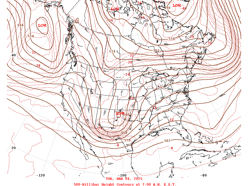 |
| Loop of WPC Surface Analysis from 12z/7 AM on 3/4 to 12z/7 AM on 3/6 in 3 hour increments | Loop of WPC 500mb Analysis from 12z on 3/4 to 12z on 3/7 in 24 hour increments |
Near-storm environment summary.
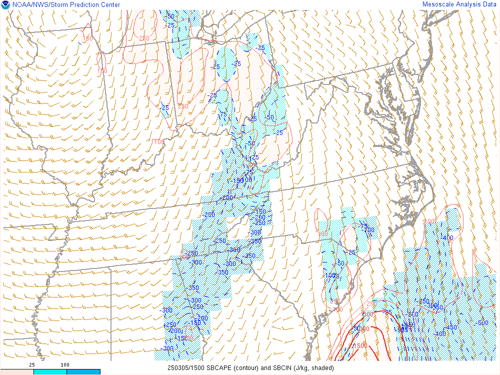 |
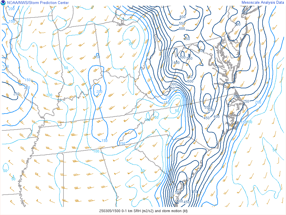 |
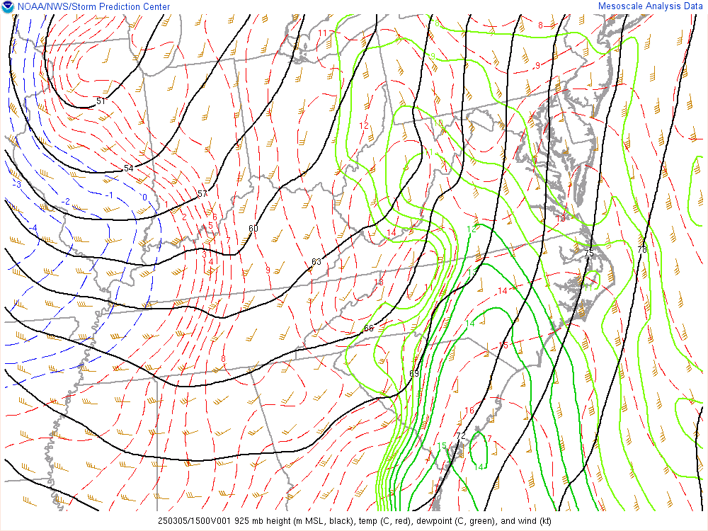 |
| Loop of SBCAPE from 10 AM to 5 PM | Loop of 0-1km SRH from 10 AM-5 PM | Loop of 925mb Height/Temp/Dew Point/Wind from 10 AM-5 PM |
Additional environmental data.
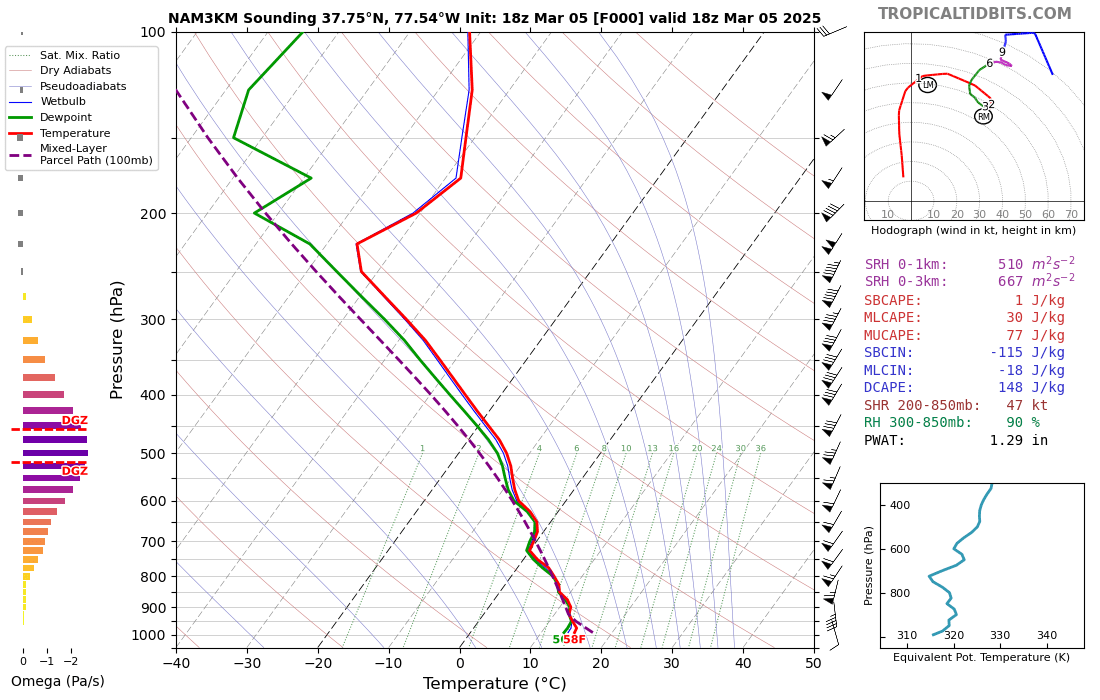 |
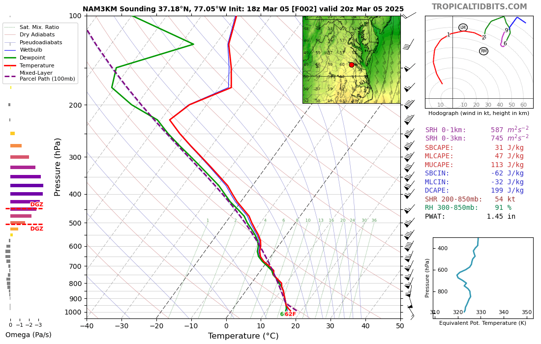 |
| 18z NAMNest Analysis Sounding from KOFP (Ashland Regional Airport in Hanover County) | 20z/3 PM NAMNest 2 Hour Forecast Sounding from KJGG (Williamsburg Airport in James City County) |
 |
Media use of NWS Web News Stories is encouraged! Please acknowledge the NWS as the source of any news information accessed from this site. |
|


 Coastal Flood
 Heat
Heat