Wakefield National Weather Service
Marine Zone Expansion to 60 NM Offshore
OVERVIEW
Beginning on or about March 3, 2026, National Weather Service (NWS) Weather Forecast Office (WFO) Wakefield, VA (AKQ) will assume forecast, watch, and warning responsibility for the coastal waters from Fenwick Island DE to Currituck Beach Light NC from 20 to 60 Nautical Miles (NM) offshore. Routine forecast services for these waters were previously the responsibility of the Ocean Prediction Center (OPC), with warning responsibility divided between WFO AKQ and OPC. This change is part of a regional improvement that will result in all forecasts and warnings for coastal waterways within 60 NM of shore originating from the local WFO across the entire Contiguous United States (CONUS). There will be no change to the current forecast and warning services provided by WFO AKQ for coastal waterways within 20 NM of shore.
JUSTIFICATION
The coastal waterways are lifelines of commerce in Mid-Atlantic, frequented by commercial, recreational, and research vessels year-round in addition to the Coastal Virginia Offshore Wind Project. Major shipping lanes pass just off our coast, with ships passing between the coast and the offshore canyons. Vessels traverse the waters just offshore the Mid-Atlantic coast moving from port to port and fishing offshore at sites such as artificial reefs and the canyons. These activities primarily take place within 60 NM of shore, with mariners depending on reliable weather forecasts from the National Weather Service to ensure the safety of themselves and their crew, passengers, and cargo while on the water.
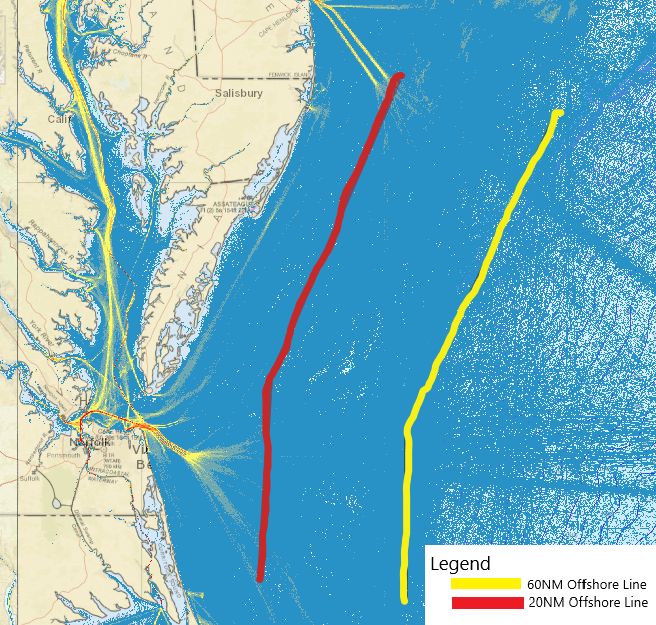
The Graphic above shows that most cargo and tanker vessels traverse about 15-60 NM offshore of Maryland, Virginia and northern Outer Banks. Expanding WFO AKQ forecast and warning responsibility to 60 NM offshore will cover significantly more commercial traffic.
With the redesignation of all forecast and warning responsibility for the coastal waters within 60 NM of shore to the local WFO, users will experience these benefits:
Improved forecast service continuity, with local WFO’s now responsible for issuing routine forecasts and warnings for all marine waters out to 60 NM offshore for the entire CONUS.
Increased number of forecast parameters with temperature, precipitation chances, and weather type among the parameters that are now available for mariners from 20 to 60 NM offshore out to 5 days in the future.
Improved forecast resolution, with point and click forecast capability now enabling mariners to get hourly forecasts for specific points (such as offshore artificial reefs) anywhere within 60 NM of shore out to 5 days in the future.
Expanded suite of short and long-fused watch/warning and advisory products to alert mariners to the potential for a variety of hazardous weather conditions.
WFO’s now have the capability to deliver Impact-based Decision Support Services (IDSS) to partners in support of incident response for incidents that occur anywhere within 60 NM of shore.
ZONE CHANGE DESCRIPTIONS
|
Previous Coverage |
 |
|
NEW (MARCH 2026) COVERAGE |
 |
| AREA | PREVIOUS ZONE NAME(S) | PREVIOUS ZONE NUMBER(S) | NEW ZONE NAME | NEW ZONE NUMBER |
| Waters from Fenwick Island DE to Chintoteague VA from 20 to 40 nm |
Waters from Fenwick Island DE to Chintoteague VA from 20 to 40 nm |
ANZ670
|
Waters from Fenwick Island DE to Chintoteague VA from 20 to 60 NM | ANZ680 |
| Waters from Chincoteague VA to Parramore Island VA from 20 to 40 nm |
Waters from Chincoteague VA to Parramore Island VA from 20 to 40 nm |
ANZ672 |
Waters from Chincoteague VA to Parramore Island VA from 20 to 60 NM | ANZ682 |
| Waters from Parramore Island VA to Cape Charles Light VA from 20 to 40 nm |
Waters from Parramore Island VA to Cape Charles Light VA from 20 to 40 nm |
ANZ674 |
Waters from Parramore Island VA to Cape Charles Light VA from 20 to 60 NM | ANZ684 |
| Waters from Cape Charles Light to Virginia - North Carolina Border from 20 to 40 nm |
Waters from Cape Charles Light to Virginia - North Carolina Border from 20 to 40 nm |
ANZ676 |
Waters from Cape Charles Light to Virginia - North Carolina Border from 20 to 60 NM | ANZ686 |
| Waters from NC VA border to Currituck Beach Light NC from 20 to 40 nm |
Waters from NC VA border to Currituck Beach Light NC from 20 to 40 nm |
ANZ678 |
Waters from NC VA border to Currituck Beach Light NC from 20 to 60 NM | ANZ688 |
FORECAST RESOURCES
| Product Name | WMO Header | AWIPS ID |
| Coastal Waters Forecast | FZUS51 | CWFAKQ |
| Marine Weather Message | WHUS71 | MWWAKQ |
| Special Marine Warning | WHUS51 | SMWAKQ |
| Marine Weather Statement | FZUS72 | MWSAKQ |
| Watch Clearance Notification | WWUS61 | WCNAKQ |
One of the most immediate and reliable ways to receive forecasts, watches, and warnings for the waterways of the Delmarva through Northern Outer Banks is through NOAA Weather Radio. The following table and map outline the best transmitter for area waterways:
| AREA | TRANSMMITTER LOCATION | TRANSMITTER FREQUENCY |
| Delmarva Peninsula including the city of Salisbury, MD | Salisbury, MD | 162.475 mhz |
| Lower Eastern Shore including the cities of Exmore, Chincoteague, and Pocomoke |
Accomack, VA |
162.525 mhz |
| Southeast VA & Northeast NC, including Tidewater area, Hampton Roads and Northeast Outer Banks | Driver, VA | 162.550 mhz |
Routine forecasts and warnings for mariners in VA, MD, eastern North Carolina waters can be found online at weather.gov/akq/marine.
Alternatively, to get the forecast for a specific point, visit weather.gov/marine/point and click on the map or enter you lat/lon.
Recorded area marine forecasts can be accessed by calling 757-899-4200, then follow menu selection (item 4).
CONTACT
Please submit any questions or comments to:
Eric Seymour
Warning Coordination Meteorologist
National Weather Service
Wakefield
10009 General Mahone Hwy
Wakefield, VA 23888
757-899-5734


 Coastal Flood
 Heat
Heat