Overview
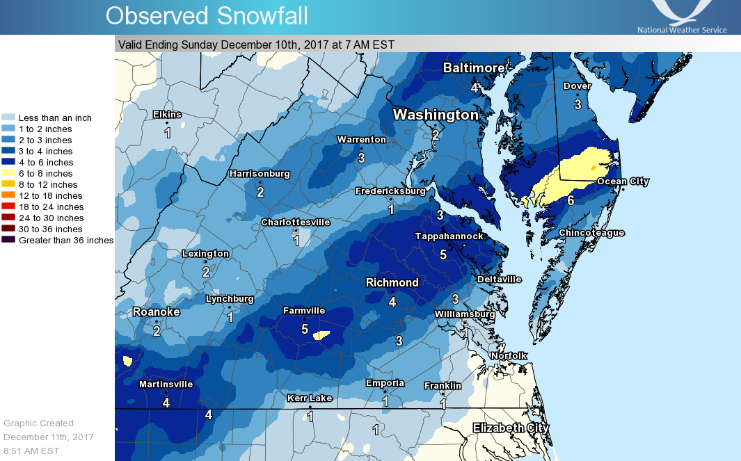
Here is the observed storm total snowfall for the Winter Storm of December 8-9, 2017. Please note that this map is interpolated, and not all spots may be an exact representation of what you may have experienced in your neighborhood. For specific amounts, please see the information below the graphic.
The National Weather Service in Wakefield would like to thank everyone for their timely snowfall reports over the weekend, including VDOT, MDOT, NCDOT, Cooperative Observers, COCORAHS observers, and the public. We greatly appreciate it!
********************STORM TOTAL SNOWFALL********************

LOCATION          STORM TOTAL     TIME/DATE   COMMENTS
                     SNOWFALL           OF
                     /INCHES/   MEASUREMENT

MARYLAND

...Dorchester County...
   3 S Cambridge          7.0  1245 AM 12/10  Storm total
   1 SE Cambridge         2.8  1208 AM 12/09  911 Call Center

...Somerset County...
   Princess Anne          2.0   535 PM 12/08  Public

...Wicomico County...
   Salisbury              7.0  1225 AM 12/09  Social Media
   Delmar                 7.0  1030 AM 12/09  East Line Road
   2 SW Salisbury         4.0  1112 PM 12/08  Social Media
   Pittsville             4.0  1110 PM 12/08  Trained Spotter
   Fruitland              3.0   700 PM 12/08  Other Federal
   1 NNW Lakewood         2.7   610 PM 12/08  Accumulation on grass

...Worcester County...
   Berlin                 4.0  1030 AM 12/09  Pitts Road
   Ocean City             2.0  1228 AM 12/09  Social Media

VIRGINIA

...Accomack County...
   WALLOPS ISLAND         0.8  1211 AM 12/09  Storm total snowfall

...AMELIA County...
   AMELIA COURT HOUSE     4.0   600 AM 12/09  DEPT OF HIGHWAYS

...Caroline County...
   Ruther Glen            2.0   805 PM 12/08  Social Media

...CHESTERFIELD County...
   1 SSE MANCHESTER       5.5   900 AM 12/09  PUBLIC

...Chesterfield County...
   5 NW Pocahontas Stat   4.0  1138 PM 12/08  Social Media
   7 E Chester            3.3   600 PM 12/09  NWS Employee
   Moseley                3.0   715 PM 12/08  Near Richmond Zoo
   4 SW Bon Air           2.8  1027 PM 12/08  Trained Spotter
   2 WSW Meadowville      1.0   700 PM 12/08  Social Media

...City of Petersburg...
   Petersburg             2.5   300 PM 12/09  Social Media

...City of Richmond...
   3 N Richmond           3.5  1118 AM 12/09  Bellevue Section

...DINWIDDIE County...
   DINWIDDIE              2.0   600 AM 12/09  DEPT OF HIGHWAYS

...Goochland County...
   2 NE Hadensville       1.0  1114 PM 12/08  Social Media

...Greensville County...
   Purdy                  0.5   700 PM 12/09  Trained Spotter

...HANOVER County...
   MECHANICSVILLE         5.0   830 AM 12/09  PUBLIC

...Hanover County...
   Ashland                3.0   600 PM 12/08  Co-Op Observer
   Atlee                  3.0  1121 PM 12/08  Social Media
   5 E Montpelier         2.4   600 PM 12/08  CoCoRaHS

...HENRICO County...
   ERIN SHADES            3.5   830 AM 12/09  PUBLIC

...Henrico County...
   2 NNE Short Pump       4.1   447 AM 12/10  Social Media
   2 E Short Pump         3.8  1216 AM 12/09  Trained Spotter
   3 N Short Pump         3.5  1119 PM 12/08  Trained Spotter
   1 NNE Longdale         3.0  1040 PM 12/08  Trained Spotter
   RICHMOND               1.0   700 PM 12/08  ASOS
   Sandston               1.0   700 PM 12/08  Snow and sleet

...LANCASTER County...
   LANCASTER              2.5   600 AM 12/09  DEPT OF HIGHWAYS

...LUNENBURG County...
   LUNENBURG              3.5   600 AM 12/09  DEPT OF HIGHWAYS

...Lunenburg County...
   1 NNE Victoria         2.6  1027 PM 12/08  Trained Spotter
   Kenbridge              2.5  1111 PM 12/08  Social Media
   3 NW Dundas            2.0  1027 PM 12/08  Trained Spotter

...MECKLENBURG County...
   SOUTH HILL             3.0   600 AM 12/09  DEPT OF HIGHWAYS

...Mecklenburg County...
   4 WNW South Hill       1.0   930 PM 12/08  Social Media

...NORTHUMBERLAND County...
   1 ESE AVALON           3.0   600 AM 12/09  DEPT OF HIGHWAYS

...NOTTOWAY County...
   NOTTOWAY               3.0   600 AM 12/09  DEPT OF HIGHWAYS

...POWHATAN County...
   POWHATAN               3.0   600 AM 12/09  PUBLIC

...Powhatan County...
   1 WNW Holly Hills      4.0  1116 PM 12/08  Social Media

...Prince Edward County...
   Farmville              3.5   730 PM 12/08  Social Media

...Prince George County...
   2 SSE Richard Bland    2.8   730 PM 12/09  Storm Total Snowfall
   2 SSE Fort Lee         1.8   700 PM 12/09  Storm Total Snowfall
   Disputanta             0.5   953 AM 12/09  Slush

...RICHMOND County...
   KENNARD                5.0   600 AM 12/09  DEPT OF HIGHWAYS

...WESTMORELAND County...
   WESTMORELAND           4.5   600 AM 12/09  DEPT OF HIGHWAYS

...Westmoreland County...
   Oak Grove              1.5  1122 PM 12/08  Social Media


**********************24 HOUR SNOWFALL**********************

LOCATION              24 HOUR     TIME/DATE   COMMENTS
                     SNOWFALL           OF
                     /INCHES/   MEASUREMENT

MARYLAND

...Dorchester County...
   2 SE Linkwood          3.5   900 AM 12/09  CoCoRaHS

...Somerset County...
   2 SSW Princess Anne    4.0   815 AM 12/09  CoCoRaHS
   2 E Oriole             3.9   800 AM 12/09  CoCoRaHS
   Deal Island            3.1   700 AM 12/09  CoCoRaHS

...Wicomico County...
   Delmar                 6.3   819 AM 12/09  CoCoRaHS
   1 W Parsonsburg        5.5   700 AM 12/09  CoCoRaHS

...Worcester County...
   3 E Bishopville        4.1   500 AM 12/09  CoCoRaHS
   1 SSW Ocean Pines      2.0   700 AM 12/09  CoCoRaHS
   Ocean Pines            2.0   730 AM 12/09  CoCoRaHS
   1 NW Cape Isle Of Wi   1.7   700 AM 12/09  CoCoRaHS
   4 SE Ironshire         1.3   800 AM 12/09  CoCoRaHS

VIRGINIA

...Accomack County...
   3 SSW Modest Town      0.5   605 AM 12/09  CoCoRaHS

...Brunswick County...
   5 N Alberta            2.2   800 AM 12/09  Co-Op Observer

...Caroline County...
   1 S Dawn               4.6   700 AM 12/09  CoCoRaHS
   3 NNW Burruss Corner   4.0   700 AM 12/09  CoCoRaHS

...Chesterfield County...
   Midlothian             3.8   800 AM 12/09  CoCoRaHS
   3 SSW Chesterfield     3.0   800 AM 12/09  CoCoRaHS
   3 WSW Beach            3.0   700 AM 12/09  CoCoRaHS
   3 SSW Midlothian       2.5   800 AM 12/09  CoCoRaHS
   4 SSW Midlothian       1.5   700 AM 12/09  CoCoRaHS
   2 SSW Meadowville      0.3   500 AM 12/09  CoCoRaHS

...City of Hopewell...
   1 NE Hopewell          3.0   700 AM 12/09  CoCoRaHS

...City of Williamsburg...
   Williamsburg Airport   0.5   700 AM 12/10  CoCoRaHS
   1 ENE Williamsburg     0.2   700 AM 12/10  CoCoRaHS

...Gloucester County...
   2 E Clay Bank          0.4   800 AM 12/10  CoCoRaHS

...Goochland County...
   Crozier                4.0   600 AM 12/09  Co-Op Observer
   2 W Tuckahoe           2.1   700 AM 12/09  CoCoRaHS

...Hanover County...
   Hewlett                4.2   700 AM 12/09  CoCoRaHS
   2 NNW Gilman           1.7   735 AM 12/09  CoCoRaHS

...Henrico County...
   Laurel                 5.0   900 AM 12/09  CoCoRaHS
   2 E Short Pump         3.8  1201 AM 12/09  CoCoRaHS
   Varina                 3.0   700 AM 12/09  CoCoRaHS
   Elko                   2.8   800 AM 12/09  CoCoRaHS

...James City County...
   1 N Five Forks         0.1   700 AM 12/10  CoCoRaHS

...King and Queen County...
   1 NE West Point        2.5   600 AM 12/09  CoCoRaHS

...Lancaster County...
   1 ESE Mollusk          2.5   700 AM 12/09  CoCoRaHS

...Louisa County...
   1 NNE Zion Crossroad   1.3   700 AM 12/10  CoCoRaHS

...Mathews County...
   Port Haywood           0.5   700 AM 12/10  CoCoRaHS

...Mecklenburg County...
   Clarksville            0.4   700 AM 12/09  Co-Op Observer

...Middlesex County...
   Stampers               0.7   700 AM 12/10  CoCoRaHS

...Northumberland County...
   2 NNE Lottsburg        2.5   700 AM 12/09  CoCoRaHS

...Prince Edward County...
   Farmville              5.0   700 AM 12/09  CoCoRaHS

...Prince George County...
   3 S Garysville         1.5   700 AM 12/09  CoCoRaHS

...Sussex County...
   Nws Offfice            0.7  1200 AM 12/10  Co-Op Observer

...Westmoreland County...
   5 ESE Montross         3.2   800 AM 12/09  CoCoRaHS


***********************SNOW ON GROUND***********************

LOCATION                 SNOW     TIME/DATE   COMMENTS
                     ON GROUND           OF
                     /INCHES/   MEASUREMENT

VIRGINIA

...Brunswick County...
   5 N Alberta            2.0   800 AM 12/10  Co-Op Observer

...Goochland County...
   Crozier                4.0   600 AM 12/10  Co-Op Observer

...Mecklenburg County...
   Clarksville            1.0   700 AM 12/09  Co-Op Observer

&&
 |
Media use of NWS Web News Stories is encouraged! Please acknowledge the NWS as the source of any news information accessed from this site. |
|


 Coastal Flood
 Heat
Heat