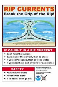
Hazardous beach conditions are expected into Wednesday for most northwest lower MI beaches, as well as some Lake Huron beaches. Read More >
|
|
|
|
295
FZUS53 KAPX 211847
SRFAPX
Surf Zone Forecast
National Weather Service Gaylord MI
247 PM EDT Tue Jul 21 2026
MIZ031-220415-
Manistee-
Including the Lake Michigan Beaches of Manistee County
247 PM EDT Tue Jul 21 2026
...BEACH HAZARDS STATEMENT IN EFFECT THROUGH WEDNESDAY EVENING...
.REST OF TODAY...
Swim Risk*..................High.
Wave Height.................4 to 6 feet.
Water Temperature...........In the lower 70s.
Weather.....................Partly sunny. Scattered showers with
isolated thunderstorms.
High Temperature............In the lower 70s.
Winds.......................Northwest winds around 20 mph.
Sunrise.....................6:22 AM.
Sunset......................9:22 PM.
.WEDNESDAY...
Swim Risk*..................High.
Wave Height.................4 to 6 feet.
Weather.....................Sunny.
High Temperature............In the upper 60s.
Winds.......................North winds 15 to 20 mph.
Sunrise.....................6:23 AM.
Sunset......................9:21 PM.
.THURSDAY...Wave height 2 feet or less. Sunny. Highs around 70.
Southwest winds around 10 mph.
.FRIDAY...Wave height 2 feet or less. Sunny. Highs in the mid 70s.
Southwest winds around 10 mph.
.SATURDAY...Wave height 2 feet or less. Sunny. Highs in the mid 70s.
Southwest winds around 15 mph.
&&
Swim Risk Category
* Low Risk - Large waves and dangerous currents are not expected,
however dangerous currents may exist at any time near piers,
breakwalls, and river outlets.
* Moderate Risk - Breaking waves and currents are expected. Stay away
from dangerous areas like piers, breakwalls, and river outlets.
Always have a flotation device with you in the water.
* High Risk - Life-threatening waves and currents are expected. Stay
out of the water and stay away from dangerous areas like piers and
breakwalls.
** For thunderstorm, waterspout, and UV definitions see:
https://www.weather.gov/beach/apx
$$
MIZ025-220415-
Benzie-
Including the Lake Michigan beaches of Benzie County
247 PM EDT Tue Jul 21 2026
...BEACH HAZARDS STATEMENT IN EFFECT THROUGH WEDNESDAY EVENING...
.REST OF TODAY...
Swim Risk*..................High.
Wave Height.................4 to 6 feet.
Water Temperature...........In the mid 60s.
Weather.....................Partly sunny. Isolated showers.
High Temperature............In the lower 70s.
Winds.......................Northwest winds around 20 mph.
Sunrise.....................6:20 AM.
Sunset......................9:23 PM.
.WEDNESDAY...
Swim Risk*..................High.
Wave Height.................3 to 5 feet.
Weather.....................Sunny.
High Temperature............In the upper 60s.
Winds.......................North winds 15 to 20 mph.
Sunrise.....................6:21 AM.
Sunset......................9:22 PM.
.THURSDAY...Wave height 2 feet or less. Sunny. Highs in the lower
70s. Southwest winds around 10 mph.
.FRIDAY...Wave height 2 feet or less. Sunny. Highs in the upper 70s.
Southwest winds around 10 mph.
.SATURDAY...Wave height 2 feet or less. Mostly sunny. Highs in the
upper 70s. Southwest winds around 15 mph.
&&
Swim Risk Category
* Low Risk - Large waves and dangerous currents are not expected,
however dangerous currents may exist at any time near piers,
breakwalls, and river outlets.
* Moderate Risk - Breaking waves and currents are expected. Stay away
from dangerous areas like piers, breakwalls, and river outlets.
Always have a flotation device with you in the water.
* High Risk - Life-threatening waves and currents are expected. Stay
out of the water and stay away from dangerous areas like piers and
breakwalls.
** For thunderstorm, waterspout, and UV definitions see:
https://www.weather.gov/beach/apx
$$
MIZ020-220415-
Leelanau-
Including the Lake Michigan beaches of Leelanau County
247 PM EDT Tue Jul 21 2026
...BEACH HAZARDS STATEMENT IN EFFECT THROUGH WEDNESDAY EVENING...
.REST OF TODAY...
Swim Risk*..................High.
Wave Height.................5 to 8 feet.
Water Temperature...........In the lower 70s.
Weather.....................Mostly cloudy. Isolated showers.
High Temperature............In the mid 70s.
Winds.......................Northwest winds around 20 mph.
Sunrise.....................6:17 AM.
Sunset......................9:22 PM.
.WEDNESDAY...
Swim Risk*..................High.
Wave Height.................3 to 5 feet.
Weather.....................Sunny.
High Temperature............In the upper 60s.
Winds.......................Northwest winds 15 to 20 mph.
Sunrise.....................6:18 AM.
Sunset......................9:21 PM.
.THURSDAY...Wave height 2 feet or less. Sunny. Highs in the lower
70s. Southwest winds around 10 mph.
.FRIDAY...Wave height 2 feet or less. Sunny. Highs in the upper 70s.
Southwest winds around 10 mph.
.SATURDAY...Wave height 2 feet or less. Mostly sunny. Highs in the
upper 70s. Southwest winds around 15 mph.
&&
Swim Risk Category
* Low Risk - Large waves and dangerous currents are not expected,
however dangerous currents may exist at any time near piers,
breakwalls, and river outlets.
* Moderate Risk - Breaking waves and currents are expected. Stay away
from dangerous areas like piers, breakwalls, and river outlets.
Always have a flotation device with you in the water.
* High Risk - Life-threatening waves and currents are expected. Stay
out of the water and stay away from dangerous areas like piers and
breakwalls.
** For thunderstorm, waterspout, and UV definitions see:
https://www.weather.gov/beach/apx
$$
MIZ026-220415-
Grand Traverse-
Including the Grand Traverse Bay beaches of Grand Traverse County
247 PM EDT Tue Jul 21 2026
.REST OF TODAY...
Swim Risk*..................High.
Wave Height.................4 to 6 feet.
Water Temperature...........In the lower 70s.
Weather.....................Mostly cloudy. Scattered showers with
isolated thunderstorms.
High Temperature............In the lower 70s.
Winds.......................Northwest winds around 20 mph.
Sunrise.....................6:17 AM.
Sunset......................9:21 PM.
.WEDNESDAY...
Swim Risk*..................Moderate.
Wave Height.................2 to 4 feet.
Weather.....................Sunny.
High Temperature............In the upper 60s.
Winds.......................Northwest winds 15 to 20 mph.
Sunrise.....................6:18 AM.
Sunset......................9:20 PM.
.THURSDAY...Wave height 2 feet or less. Sunny. Highs in the mid 70s.
Southwest winds around 5 mph.
.FRIDAY...Wave height 2 feet or less. Sunny. Highs in the upper 70s.
Southwest winds around 10 mph.
.SATURDAY...Wave height 2 feet or less. Mostly sunny. Highs in the
upper 70s. Southwest winds around 10 mph.
&&
Swim Risk Category
* Low Risk - Large waves and dangerous currents are not expected,
however dangerous currents may exist at any time near piers,
breakwalls, and river outlets.
* Moderate Risk - Breaking waves and currents are expected. Stay away
from dangerous areas like piers, breakwalls, and river outlets.
Always have a flotation device with you in the water.
* High Risk - Life-threatening waves and currents are expected. Stay
out of the water and stay away from dangerous areas like piers and
breakwalls.
** For thunderstorm, waterspout, and UV definitions see:
https://www.weather.gov/beach/apx
$$
MIZ021-220415-
Antrim-
Including the Lake Michigan beaches of Antrim County
247 PM EDT Tue Jul 21 2026
...BEACH HAZARDS STATEMENT IN EFFECT THROUGH WEDNESDAY EVENING...
.REST OF TODAY...
Swim Risk*..................High.
Wave Height.................4 to 7 feet.
Water Temperature...........In the lower 70s.
Weather.....................Mostly cloudy. Scattered showers.
High Temperature............In the lower 70s.
Winds.......................Northwest winds around 20 mph.
Sunrise.....................6:15 AM.
Sunset......................9:21 PM.
.WEDNESDAY...
Swim Risk*..................High.
Wave Height.................3 to 5 feet.
Weather.....................Sunny.
High Temperature............In the upper 60s.
Winds.......................Northwest winds 15 to 20 mph.
Sunrise.....................6:16 AM.
Sunset......................9:20 PM.
.THURSDAY...Wave height 2 feet or less. Sunny. Highs in the lower
70s. Southwest winds around 10 mph.
.FRIDAY...Wave height 2 feet or less. Sunny. Highs in the upper 70s.
Southwest winds around 10 mph.
.SATURDAY...Wave height 2 feet or less. Mostly sunny. Highs in the
upper 70s. Southwest winds around 10 mph.
&&
Swim Risk Category
* Low Risk - Large waves and dangerous currents are not expected,
however dangerous currents may exist at any time near piers,
breakwalls, and river outlets.
* Moderate Risk - Breaking waves and currents are expected. Stay away
from dangerous areas like piers, breakwalls, and river outlets.
Always have a flotation device with you in the water.
* High Risk - Life-threatening waves and currents are expected. Stay
out of the water and stay away from dangerous areas like piers and
breakwalls.
** For thunderstorm, waterspout, and UV definitions see:
https://www.weather.gov/beach/apx
$$
MIZ099-220415-
Charlevoix-
Including the Lake Michigan beaches of Charlevoix County
247 PM EDT Tue Jul 21 2026
...BEACH HAZARDS STATEMENT IN EFFECT THROUGH WEDNESDAY EVENING...
.REST OF TODAY...
Swim Risk*..................High.
Wave Height.................4 to 7 feet.
Water Temperature...........Around 70.
Weather.....................Mostly cloudy. Isolated showers.
High Temperature............In the lower 70s.
Winds.......................Northwest winds around 20 mph.
Sunrise.....................6:14 AM.
Sunset......................9:21 PM.
.WEDNESDAY...
Swim Risk*..................High.
Wave Height.................3 to 5 feet.
Weather.....................Sunny.
High Temperature............In the upper 60s.
Winds.......................Northwest winds 15 to 20 mph.
Sunrise.....................6:15 AM.
Sunset......................9:20 PM.
.THURSDAY...Wave height 2 feet or less. Sunny. Highs in the lower
70s. Southwest winds around 10 mph.
.FRIDAY...Wave height 2 feet or less. Sunny. Highs in the upper 70s.
Southwest winds around 10 mph.
.SATURDAY...Wave height 2 feet or less. Mostly sunny. Highs in the
upper 70s. Southwest winds around 15 mph.
&&
Swim Risk Category
* Low Risk - Large waves and dangerous currents are not expected,
however dangerous currents may exist at any time near piers,
breakwalls, and river outlets.
* Moderate Risk - Breaking waves and currents are expected. Stay away
from dangerous areas like piers, breakwalls, and river outlets.
Always have a flotation device with you in the water.
* High Risk - Life-threatening waves and currents are expected. Stay
out of the water and stay away from dangerous areas like piers and
breakwalls.
** For thunderstorm, waterspout, and UV definitions see:
https://www.weather.gov/beach/apx
$$
MIZ016-220415-
Emmet-
Including the Lake Michigan beaches of Emmet County
247 PM EDT Tue Jul 21 2026
...BEACH HAZARDS STATEMENT IN EFFECT THROUGH WEDNESDAY EVENING...
.REST OF TODAY...
Swim Risk*..................High.
Wave Height.................4 to 7 feet.
Water Temperature...........Around 70.
Weather.....................Mostly cloudy. Isolated showers.
High Temperature............Around 70.
Winds.......................Northwest winds around 20 mph.
Sunrise.....................6:12 AM.
Sunset......................9:20 PM.
.WEDNESDAY...
Swim Risk*..................High.
Wave Height.................3 to 5 feet.
Weather.....................Sunny.
High Temperature............In the upper 60s.
Winds.......................Northwest winds 15 to 20 mph.
Sunrise.....................6:13 AM.
Sunset......................9:19 PM.
.THURSDAY...Wave height 2 feet or less. Sunny. Highs in the lower
70s. Southwest winds around 10 mph.
.FRIDAY...Wave height 2 feet or less. Sunny. Highs in the mid 70s.
Southwest winds around 10 mph.
.SATURDAY...Wave height 2 feet or less. Mostly sunny. A slight chance
of showers. Highs in the mid 70s. Southwest winds around 15 mph.
&&
Swim Risk Category
* Low Risk - Large waves and dangerous currents are not expected,
however dangerous currents may exist at any time near piers,
breakwalls, and river outlets.
* Moderate Risk - Breaking waves and currents are expected. Stay away
from dangerous areas like piers, breakwalls, and river outlets.
Always have a flotation device with you in the water.
* High Risk - Life-threatening waves and currents are expected. Stay
out of the water and stay away from dangerous areas like piers and
breakwalls.
** For thunderstorm, waterspout, and UV definitions see:
https://www.weather.gov/beach/apx
$$
MIZ017-220415-
Cheboygan-
Including the Lake Huron beaches of Cheboygan County
247 PM EDT Tue Jul 21 2026
.REST OF TODAY...
Swim Risk*..................High.
Wave Height.................3 to 5 feet.
Water Temperature...........Around 70.
Weather.....................Mostly cloudy. Scattered showers.
High Temperature............In the lower 70s.
Winds.......................Northwest winds around 20 mph.
Sunrise.....................6:10 AM.
Sunset......................9:19 PM.
.WEDNESDAY...
Swim Risk*..................High.
Wave Height.................3 to 5 feet.
Weather.....................Sunny.
High Temperature............Around 70.
Winds.......................Northwest winds 15 to 20 mph.
Sunrise.....................6:11 AM.
Sunset......................9:18 PM.
.THURSDAY...Wave height 2 feet or less. Sunny. Highs in the mid 70s.
West winds around 10 mph.
.FRIDAY...Wave height 2 feet or less. Sunny. Highs around 80.
Southwest winds around 10 mph.
.SATURDAY...Wave height 2 feet or less. Mostly sunny. A slight chance
of showers. Highs in the upper 70s. Southwest winds around 10 mph.
&&
Swim Risk Category
* Low Risk - Large waves and dangerous currents are not expected,
however dangerous currents may exist at any time near piers,
breakwalls, and river outlets.
* Moderate Risk - Breaking waves and currents are expected. Stay away
from dangerous areas like piers, breakwalls, and river outlets.
Always have a flotation device with you in the water.
* High Risk - Life-threatening waves and currents are expected. Stay
out of the water and stay away from dangerous areas like piers and
breakwalls.
** For thunderstorm, waterspout, and UV definitions see:
https://www.weather.gov/beach/apx
$$
MIZ018-220415-
Presque Isle-
Including the Lake Huron beaches of Presque Isle County
247 PM EDT Tue Jul 21 2026
...BEACH HAZARDS STATEMENT IN EFFECT THROUGH WEDNESDAY EVENING...
.REST OF TODAY...
Swim Risk*..................High.
Wave Height.................5 to 8 feet.
Water Temperature...........In the upper 60s.
Weather.....................Partly sunny. Scattered showers with
isolated thunderstorms.
High Temperature............In the mid 70s.
Winds.......................Northwest winds around 20 mph.
Sunrise.....................6:07 AM.
Sunset......................9:15 PM.
.WEDNESDAY...
Swim Risk*..................High.
Wave Height.................5 to 8 feet.
Weather.....................Sunny.
High Temperature............In the upper 60s.
Winds.......................Northwest winds 15 to 20 mph.
Sunrise.....................6:09 AM.
Sunset......................9:14 PM.
.THURSDAY...Wave height 2 feet or less. Sunny. Highs in the lower
70s. West winds around 10 mph.
.FRIDAY...Wave height 2 feet or less. Sunny. Highs around 80.
Southwest winds around 10 mph.
.SATURDAY...Wave height 2 feet or less. Mostly sunny. Highs around
80. Southwest winds around 10 mph.
&&
Swim Risk Category
* Low Risk - Large waves and dangerous currents are not expected,
however dangerous currents may exist at any time near piers,
breakwalls, and river outlets.
* Moderate Risk - Breaking waves and currents are expected. Stay away
from dangerous areas like piers, breakwalls, and river outlets.
Always have a flotation device with you in the water.
* High Risk - Life-threatening waves and currents are expected. Stay
out of the water and stay away from dangerous areas like piers and
breakwalls.
** For thunderstorm, waterspout, and UV definitions see:
https://www.weather.gov/beach/apx
$$
MIZ024-220415-
Alpena-
Including the Lake Huron beaches of Alpena County
247 PM EDT Tue Jul 21 2026
.REST OF TODAY...
Swim Risk*..................High.
Wave Height.................3 to 5 feet.
Water Temperature...........In the upper 60s.
Weather.....................Partly sunny. Numerous showers and
scattered thunderstorms.
High Temperature............In the mid 70s.
Winds.......................Northwest winds around 20 mph.
Sunrise.....................6:07 AM.
Sunset......................9:13 PM.
.WEDNESDAY...
Swim Risk*..................High.
Wave Height.................4 to 6 feet.
Weather.....................Partly sunny until 7 AM, then sunny.
High Temperature............In the upper 60s.
Winds.......................Northwest winds 15 to 20 mph.
Sunrise.....................6:08 AM.
Sunset......................9:12 PM.
.THURSDAY...Wave height 2 feet or less. Sunny. Highs in the lower
70s. West winds around 5 mph.
.FRIDAY...Wave height 2 feet or less. Sunny. Highs in the upper 70s.
South winds around 10 mph.
.SATURDAY...Wave height 2 feet or less. Mostly sunny. Highs in the
upper 70s. South winds around 10 mph.
&&
Swim Risk Category
* Low Risk - Large waves and dangerous currents are not expected,
however dangerous currents may exist at any time near piers,
breakwalls, and river outlets.
* Moderate Risk - Breaking waves and currents are expected. Stay away
from dangerous areas like piers, breakwalls, and river outlets.
Always have a flotation device with you in the water.
* High Risk - Life-threatening waves and currents are expected. Stay
out of the water and stay away from dangerous areas like piers and
breakwalls.
** For thunderstorm, waterspout, and UV definitions see:
https://www.weather.gov/beach/apx
$$
MIZ030-220415-
Alcona-
Including the Lake Huron beaches of Alcona County
247 PM EDT Tue Jul 21 2026
.REST OF TODAY...
Swim Risk*..................Moderate.
Wave Height.................2 to 3 feet.
Water Temperature...........In the upper 60s.
Weather.....................Partly sunny. Numerous showers and
scattered thunderstorms.
High Temperature............In the upper 70s.
Winds.......................Northwest winds around 15 mph.
Sunrise.....................6:08 AM.
Sunset......................9:11 PM.
.WEDNESDAY...
Swim Risk*..................Moderate.
Wave Height.................2 to 4 feet.
Weather.....................Mostly sunny.
High Temperature............Around 70.
Winds.......................Northwest winds 15 to 20 mph.
Sunrise.....................6:09 AM.
Sunset......................9:10 PM.
.THURSDAY...Wave height 2 feet or less. Sunny. Highs in the mid 70s.
Southwest winds around 5 mph.
.FRIDAY...Wave height 2 feet or less. Sunny. Highs in the upper 70s.
Southwest winds around 10 mph.
.SATURDAY...Wave height 2 feet or less. Sunny. Highs in the upper
70s. South winds around 10 mph.
&&
Swim Risk Category
* Low Risk - Large waves and dangerous currents are not expected,
however dangerous currents may exist at any time near piers,
breakwalls, and river outlets.
* Moderate Risk - Breaking waves and currents are expected. Stay away
from dangerous areas like piers, breakwalls, and river outlets.
Always have a flotation device with you in the water.
* High Risk - Life-threatening waves and currents are expected. Stay
out of the water and stay away from dangerous areas like piers and
breakwalls.
** For thunderstorm, waterspout, and UV definitions see:
https://www.weather.gov/beach/apx
$$
MIZ036-220415-
Iosco-
Including the Lake Huron beaches of Iosco County
247 PM EDT Tue Jul 21 2026
.REST OF TODAY...
Swim Risk*..................Moderate.
Wave Height.................2 to 3 feet.
Water Temperature...........Around 70.
Weather.....................Mostly sunny. Numerous showers and
scattered thunderstorms.
High Temperature............In the lower 80s.
Winds.......................Northwest winds around 15 mph.
Sunrise.....................6:10 AM.
Sunset......................9:10 PM.
.WEDNESDAY...
Swim Risk*..................Moderate.
Wave Height.................2 to 3 feet.
Weather.....................Mostly sunny.
High Temperature............In the lower 70s.
Winds.......................Northwest winds 15 to 20 mph.
Sunrise.....................6:11 AM.
Sunset......................9:10 PM.
.THURSDAY...Wave height 2 feet or less. Sunny. Highs in the mid 70s.
West winds around 5 mph.
.FRIDAY...Wave height 2 feet or less. Sunny. Highs in the upper 70s.
Southwest winds around 10 mph.
.SATURDAY...Wave height 2 feet or less. Sunny. Highs in the upper
70s. Southwest winds around 10 mph.
&&
Swim Risk Category
* Low Risk - Large waves and dangerous currents are not expected,
however dangerous currents may exist at any time near piers,
breakwalls, and river outlets.
* Moderate Risk - Breaking waves and currents are expected. Stay away
from dangerous areas like piers, breakwalls, and river outlets.
Always have a flotation device with you in the water.
* High Risk - Life-threatening waves and currents are expected. Stay
out of the water and stay away from dangerous areas like piers and
breakwalls.
** For thunderstorm, waterspout, and UV definitions see:
https://www.weather.gov/beach/apx
$$
MIZ042-220415-
Arenac-
Including the Lake Huron beaches of Arenac County
247 PM EDT Tue Jul 21 2026
.REST OF TODAY...
Swim Risk*..................Moderate.
Wave Height.................2 to 3 feet.
Water Temperature...........In the lower 70s.
Weather.....................Mostly sunny. Numerous showers and
scattered thunderstorms.
High Temperature............In the lower 80s.
Winds.......................West winds around 15 mph.
Sunrise.....................6:12 AM.
Sunset......................9:11 PM.
.WEDNESDAY...
Swim Risk*..................Low.
Wave Height.................2 feet or less.
Weather.....................Mostly sunny.
High Temperature............In the lower 70s.
Winds.......................Northwest winds 15 to 20 mph.
Sunrise.....................6:13 AM.
Sunset......................9:10 PM.
.THURSDAY...Wave height 2 feet or less. Sunny. Highs in the mid 70s.
Northwest winds around 5 mph.
.FRIDAY...Wave height 2 feet or less. Sunny. Highs in the upper 70s.
Southeast winds around 5 mph.
.SATURDAY...Wave height 2 feet or less. Sunny. Highs in the lower
80s. South winds around 5 mph.
&&
Swim Risk Category
* Low Risk - Large waves and dangerous currents are not expected,
however dangerous currents may exist at any time near piers,
breakwalls, and river outlets.
* Moderate Risk - Breaking waves and currents are expected. Stay away
from dangerous areas like piers, breakwalls, and river outlets.
Always have a flotation device with you in the water.
* High Risk - Life-threatening waves and currents are expected. Stay
out of the water and stay away from dangerous areas like piers and
breakwalls.
** For thunderstorm, waterspout, and UV definitions see:
https://www.weather.gov/beach/apx
$$
MIZ095-220415-
Western Mackinac-
Including the Lake Michigan beaches of Western Mackinac County
247 PM EDT Tue Jul 21 2026
.REST OF TODAY...
Swim Risk*..................Moderate.
Wave Height.................2 to 3 feet.
Water Temperature...........In the upper 60s.
Weather.....................Partly sunny. Isolated showers.
High Temperature............In the upper 60s.
Winds.......................Northwest winds around 20 mph.
Sunrise.....................6:12 AM.
Sunset......................9:25 PM.
.WEDNESDAY...
Swim Risk*..................Low.
Wave Height.................2 feet or less.
Weather.....................Sunny.
High Temperature............In the upper 60s.
Winds.......................Northwest winds 15 to 20 mph.
Sunrise.....................6:13 AM.
Sunset......................9:24 PM.
.THURSDAY...Wave height 2 feet or less. Sunny. Highs in the lower
70s. Southwest winds around 10 mph.
.FRIDAY...Wave height 2 feet or less. Sunny. Highs in the mid 70s.
Southwest winds around 15 mph.
.SATURDAY...Wave height 2 feet or less. Mostly sunny. A chance of
showers. Highs in the lower 70s. Southwest winds around 20 mph.
&&
Swim Risk Category
* Low Risk - Large waves and dangerous currents are not expected,
however dangerous currents may exist at any time near piers,
breakwalls, and river outlets.
* Moderate Risk - Breaking waves and currents are expected. Stay away
from dangerous areas like piers, breakwalls, and river outlets.
Always have a flotation device with you in the water.
* High Risk - Life-threatening waves and currents are expected. Stay
out of the water and stay away from dangerous areas like piers and
breakwalls.
** For thunderstorm, waterspout, and UV definitions see:
https://www.weather.gov/beach/apx
$$
MIZ096-220415-
Eastern Mackinac-
Including the Lake Michigan and Huron beaches of Eastern Mackinac
County
247 PM EDT Tue Jul 21 2026
.REST OF TODAY...
Swim Risk*..................High.
Wave Height.................3 to 5 feet.
Water Temperature...........In the mid 60s.
Weather.....................Mostly cloudy. Scattered showers.
High Temperature............Around 70.
Winds.......................Northwest winds around 20 mph.
Sunrise.....................6:10 AM.
Sunset......................9:21 PM.
.WEDNESDAY...
Swim Risk*..................Moderate.
Wave Height.................2 to 3 feet.
Weather.....................Sunny.
High Temperature............In the upper 60s.
Winds.......................Northwest winds 15 to 20 mph.
Sunrise.....................6:11 AM.
Sunset......................9:20 PM.
.THURSDAY...Wave height 2 feet or less. Sunny. Highs in the lower
70s. West winds around 10 mph.
.FRIDAY...Wave height 2 feet or less. Sunny. Highs in the mid 70s.
Southwest winds around 15 mph.
.SATURDAY...Wave height 2 feet or less. Mostly sunny. A slight chance
of showers. Highs in the mid 70s. Southwest winds around 15 mph.
&&
Swim Risk Category
* Low Risk - Large waves and dangerous currents are not expected,
however dangerous currents may exist at any time near piers,
breakwalls, and river outlets.
* Moderate Risk - Breaking waves and currents are expected. Stay away
from dangerous areas like piers, breakwalls, and river outlets.
Always have a flotation device with you in the water.
* High Risk - Life-threatening waves and currents are expected. Stay
out of the water and stay away from dangerous areas like piers and
breakwalls.
** For thunderstorm, waterspout, and UV definitions see:
https://www.weather.gov/beach/apx
$$
MIZ088-220415-
Eastern Chippewa-
Including the Lake Huron beaches of Chippewa County
247 PM EDT Tue Jul 21 2026
.REST OF TODAY...
Swim Risk*..................Moderate.
Wave Height.................2 to 4 feet.
Water Temperature...........In the mid 60s.
Weather.....................Partly sunny. Scattered showers.
High Temperature............Around 70.
Winds.......................West winds around 20 mph.
Sunrise.....................6:06 AM.
Sunset......................9:18 PM.
.WEDNESDAY...
Swim Risk*..................Moderate.
Wave Height.................2 to 3 feet.
Weather.....................Sunny.
High Temperature............In the upper 60s.
Winds.......................Northwest winds 15 to 20 mph.
Sunrise.....................6:07 AM.
Sunset......................9:17 PM.
.THURSDAY...Wave height 2 feet or less. Sunny. Highs in the lower
70s. West winds around 10 mph.
.FRIDAY...Wave height 2 feet or less. Sunny. Highs in the upper 70s.
Southwest winds around 10 mph.
.SATURDAY...Wave height 2 feet or less. Mostly sunny. A slight chance
of showers. Highs in the mid 70s. South winds around 10 mph.
&&
Swim Risk Category
* Low Risk - Large waves and dangerous currents are not expected,
however dangerous currents may exist at any time near piers,
breakwalls, and river outlets.
* Moderate Risk - Breaking waves and currents are expected. Stay away
from dangerous areas like piers, breakwalls, and river outlets.
Always have a flotation device with you in the water.
* High Risk - Life-threatening waves and currents are expected. Stay
out of the water and stay away from dangerous areas like piers and
breakwalls.
** For thunderstorm, waterspout, and UV definitions see:
https://www.weather.gov/beach/apx
$$
MIZ098-220415-
Beaver Island-
Including the beaches of Beaver Island
247 PM EDT Tue Jul 21 2026
...BEACH HAZARDS STATEMENT IN EFFECT THROUGH WEDNESDAY EVENING...
.REST OF TODAY...
Swim Risk*..................High.
Wave Height.................4 to 7 feet.
Water Temperature...........In the upper 60s.
Weather.....................Mostly cloudy until 4 PM, then partly
sunny.
High Temperature............Around 70.
Winds.......................Northwest winds around 20 mph.
Sunrise.....................6:14 AM.
Sunset......................9:23 PM.
.WEDNESDAY...
Swim Risk*..................Moderate.
Wave Height.................2 to 4 feet.
Weather.....................Sunny.
High Temperature............In the upper 60s.
Winds.......................Northwest winds 15 to 20 mph.
Sunrise.....................6:15 AM.
Sunset......................9:22 PM.
.THURSDAY...Wave height 2 feet or less. Sunny. Highs in the mid 70s.
Southwest winds around 10 mph.
.FRIDAY...Wave height 2 feet or less. Sunny. Highs in the upper 70s.
Southwest winds around 15 mph.
.SATURDAY...Wave height 2 feet or less. Mostly sunny. A slight chance
of showers. Highs in the mid 70s. Southwest winds around 20 mph.
&&
Swim Risk Category
* Low Risk - Large waves and dangerous currents are not expected,
however dangerous currents may exist at any time near piers,
breakwalls, and river outlets.
* Moderate Risk - Breaking waves and currents are expected. Stay away
from dangerous areas like piers, breakwalls, and river outlets.
Always have a flotation device with you in the water.
* High Risk - Life-threatening waves and currents are expected. Stay
out of the water and stay away from dangerous areas like piers and
breakwalls.
** For thunderstorm, waterspout, and UV definitions see:
https://www.weather.gov/beach/apx
$$
MIZ097-220415-
Mackinac Island-
Including the beaches of Mackinac Island
247 PM EDT Tue Jul 21 2026
.REST OF TODAY...
Swim Risk*..................Moderate.
Wave Height.................2 to 4 feet.
Water Temperature...........In the upper 60s.
Weather.....................Mostly cloudy until 4 PM, then mostly
sunny until 5 PM, then mostly cloudy.
Scattered showers.
High Temperature............In the upper 60s.
Winds.......................Northwest winds around 20 mph.
Sunrise.....................6:09 AM.
Sunset......................9:20 PM.
.WEDNESDAY...
Swim Risk*..................Moderate.
Wave Height.................2 to 3 feet.
Weather.....................Sunny.
High Temperature............In the upper 60s.
Winds.......................Northwest winds 15 to 20 mph.
Sunrise.....................6:11 AM.
Sunset......................9:19 PM.
.THURSDAY...Wave height 2 feet or less. Sunny. Highs in the lower
70s. West winds around 15 mph.
.FRIDAY...Wave height 2 feet or less. Sunny. Highs in the mid 70s.
Southwest winds around 15 mph.
.SATURDAY...Wave height 2 feet or less. Mostly sunny. A slight chance
of showers. Highs in the mid 70s. Southwest winds around 15 mph.
&&
Swim Risk Category
* Low Risk - Large waves and dangerous currents are not expected,
however dangerous currents may exist at any time near piers,
breakwalls, and river outlets.
* Moderate Risk - Breaking waves and currents are expected. Stay away
from dangerous areas like piers, breakwalls, and river outlets.
Always have a flotation device with you in the water.
* High Risk - Life-threatening waves and currents are expected. Stay
out of the water and stay away from dangerous areas like piers and
breakwalls.
** For thunderstorm, waterspout, and UV definitions see:
https://www.weather.gov/beach/apx
$$