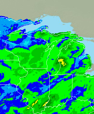
Please use the links below to find out more information on current flooding issues and details of any warnings that may be currently issued.
Quick Links:
Latest Information
|
||||||||
Current River/Streamflow Information
|
|||||
Precipitation Info/Forecasts
|
||||||||
871

ACUS01 KWNS 230522

SWODY1

SPC AC 230521


Day 1 Convective Outlook

NWS Storm Prediction Center Norman OK

1221 AM CDT Thu Jul 23 2026


Valid 231200Z - 241200Z


...THERE IS A SLIGHT RISK OF SEVERE THUNDERSTORMS ACROSS PORTIONS OF

WESTERN KANSAS...


...SUMMARY...

Widely scattered severe storms capable of severe wind gusts and

large hail are possible over portions of the central and southern

High Plains Thursday afternoon and evening. More isolated

occurrences of damaging wind are possible from the middle Texas

coast into Deep South Texas, the eastern Carolinas, and parts of the

Columbia Basin into the northern Rockies.


...Synopsis...


A short-wave trough over the central Rockies late this evening is

forecast to progress slowly into the central High Plains by Thursday

afternoon, within the northeast periphery of a strengthening

mid/upper-level high over the southern Rockies. Downstream from

those developments, a short-wave trough will translate through New

England with a trailing vorticity ribbon and associated belt of

enhanced mid-level flow across the southern Mid-Atlantic. Elsewhere,

Tropical Storm Bertha is forecast to advance from just off the

southwest LA coast to the middle TX coast by Thursday evening.


At the surface, a stationary front currently extending from the CO

Front Range through the OK and TX Panhandles into the Red River

Valley is forecast to drift north through portions of western KS on

Thursday immediately ahead of a thermal low/lee cyclone over

southeast CO and southwest KS. A dryline will extend south from the

surface low-front triple point into the central or eastern OK and TX

Panhandles by mid- to late afternoon.


...Central and southern High Plains...


Strong boundary-layer heating is forecast in the vicinity of the

surface front and dryline Thursday afternoon with temperatures in

the mid 90s to around 105. The hot temperatures will combine with

dewpoints in the mid 50s to mid 60s and modestly steep mid-level

lapse rates to yield a narrow axis of moderate instability with

MLCAPE of 1500-2500 J/kg. Forcing for ascent preceding the

short-wave trough is expected to contribute to isolated to widely

scattered thunderstorms by mid afternoon from the vicinity of the

thermal low in southeast CO to along the front and dryline from

northeast CO into the OK and TX Panhandles.


Forecast soundings along the front indicate a vertically veering

wind profile with 30-35 kt of deep-layer shear, which will be

sufficient for at least episodic supercell structures with a risk

for large hail. In contrast, the storms forming in the hot, deeply

mixed air mass west of the boundary are more likely to produce

sporadic severe wind gusts. A corridor of potentially more

concentrated severe wind gusts may materialize across portions of

southwest KS by evening, where a number of the 00z CAMs indicate the

evolution of an organized cold pool.


...Middle Texas Coast to Deep South Texas...


A channel of enhanced mid-level flow is forecast to precede Bertha

atop a hot and moist boundary layer, with moderate instability

developing by afternoon along the middle TX coast. Similar to

Wednesday, widely scattered thunderstorms are expected during the

afternoon within an environment characterized by 30-40 kt of

deep-layer shear, steep low-level lapse rates, and high PW content.

As such, the potential will exist for locally damaging downburst

winds as storms spread southwest along the coast into Deep South TX

during the afternoon and evening hours.


...Columbia Basin into northern Rockies...


Mid/upper-level winds are forecast to strengthen across the area on

Thursday in tandem with a subtle disturbance moving through portions

of OR and WA. Daytime heating along favored terrain in conjunction

with the glancing influence of the passing disturbance will aid in

isolated to widely scattered thunderstorms by mid afternoon within a

moderately unstable and steep lapse rate environment. The

strengthening upper-level winds will enhance vertical shear,

supporting the potential for some storm organization with an

associated risk for locally damaging wind gusts and marginally

severe hail.


...Eastern Carolinas...


Thunderstorms are expected to be ongoing at 12Z Thursday along a

west-to-east-oriented front in NC. Breaks in the clouds south of the

early-day storms will combine with a moist boundary layer to yield

an axis of moderate instability by afternoon across portions of

southeast NC into far eastern SC. A corridor of more concentrated

thunderstorm development is possible in that area, near the

intersection of the outflow from the morning storms with the

sea-breeze boundary. Modest deep-layer shear will coincide with

steepening low-level lapse rates and high PW content to yield

locally intense wet microbursts capable of damaging winds.


..Mead/Weinman.. 07/23/2026


$$
964

ACUS02 KWNS 230523

SWODY2

SPC AC 230521


Day 2 Convective Outlook

NWS Storm Prediction Center Norman OK

1221 AM CDT Thu Jul 23 2026


Valid 241200Z - 251200Z


...THERE IS A SLIGHT RISK OF SEVERE THUNDERSTORMS ACROSS PORTIONS OF

NORTH DAKOTA INTO NORTHWEST MINNESOTA...


...SUMMARY...

Isolated severe thunderstorms are possible on Friday across portions

of the Dakotas into northern Minnesota.


...Dakotas into northern MN...


Strengthening northwesterly flow aloft will overspread the region

Friday afternoon into early Saturday in response to a shortwave

upper trough moving across Manitoba/western Ontario and the northern

Great Lakes. At the surface, a front will develop south/southeast

across parts of north Dakota and northern MN.


South/southwesterly low-level flow ahead of the front will transport

modest boundary layer moisture northward across parts of ND/SD and

northern/central MN. This will occur on the eastern periphery of a

strong upper ridge building over the Rockies/High Plains. As a

result of upper ridging, warm temperatures in the 850-700 mb layer

may result in at least weak capping over portions of the region.

Nevertheless, a plume of steep midlevel lapse rates will support

moderate destabilization (1000-2000 J/kg MLCAPE).


Vertically veering wind profiles, also increasing in speed with

height, will result in supercell wind profiles. Forecast soundings

show a well-mixed boundary layer, with steep 0-3 km lapse rates.

Organized cells are expected to develop by late afternoon near the

surface boundary and spread east/southeast with time through the

evening. A low-level jet is also forecast to increase during the

evening/nighttime hours. The main risk with these storms will be

from large hail and strong to severe wind gusts. If storms can

become surface-based, a tornado or two also could occur. The

strengthening low-level jet could maintain elevated convection into

the nighttime hours across northern MN, but instability weakens an

inhibition increases with south and east extent across the Upper MS

Valley. This should keep severe potential relatively confined within

a narrow corridor across portions of the Dakotas into northern MN.


...SC vicinity...


Isolated to scattered thunderstorms are expected Friday afternoon

within a moderately unstable and very moist airmass. Vertically

veering flow, increasing to around 20-30 kt around 1-3 km will

provide around 25 kt effective shear as a surface boundary sags

south and east across the region. This may be sufficient for a

couple of organized clusters capable of producing sporadic wind

damage.


..Leitman.. 07/23/2026


$$
815

NWUS53 KAPX 221338

LSRAPX


Preliminary Local Storm Report...Summary

National Weather Service Gaylord MI

938 AM EDT Wed Jul 22 2026


...Maximum Winds Observed Across Northern Michigan July 21, 2026...


..TIME...   ...EVENT...      ...CITY LOCATION...     ...LAT.LON...

..DATE...   ....MAG....      ..COUNTY LOCATION..ST.. ...SOURCE....

            ..REMARKS..


0221 PM     Non-Tstm Wnd Gst 1 SW Frankfort          44.63N 86.25W

07/21/2026  M48 MPH          LMZ346             MI   Mesonet


            Mesonet station XFLT Frankfort Light.


0555 PM     Non-Tstm Wnd Gst 1 ESE Roscommon County  44.35N 84.67W

07/21/2026  M43 MPH          Roscommon          MI   ASOS


            ASOS station KHTL Houghton Lake - Roscommon

            County Airport.


0606 PM     Non-Tstm Wnd Gst 4 NNW Bay Mills         46.48N 84.63W

07/21/2026  M42 MPH          Chippewa           MI   Buoy


            Buoy station PTIM4 Point Iroquois, MI.


0606 PM     Non-Tstm Wnd Gst 4 NNW Bay Mills         46.48N 84.63W

07/21/2026  M42 MPH          Chippewa           MI   Buoy


            Buoy station PTIM4 Point Iroquois, MI.


0406 PM     Non-Tstm Wnd Gst 3 NNW Munuscong         46.28N 84.21W

07/21/2026  M42 MPH          LSZ322             MI   Buoy


            Buoy station WNEM4 West Neebish Island, MI.


0719 PM     Non-Tstm Wnd Gst 1 NNE Leland            45.02N 85.76W

07/21/2026  M42 MPH          LMZ344             MI   Mesonet


            Mesonet station XLEL Leland Harbor.


0413 PM     Non-Tstm Wnd Gst 3 SSE East Tawas        44.25N 83.46W

07/21/2026  M41 MPH          Iosco              MI   Mesonet


            Mesonet station XTAW Tawas Point.


0800 PM     Non-Tstm Wnd Gst 4 SW Leland             44.98N 85.83W

07/21/2026  M40 MPH          LMZ344             MI   Mesonet


            Mesonet station 45183 3 WSW Leland.


0428 PM     Non-Tstm Wnd Gst 1 SSW Gaylord           45.02N 84.68W

07/21/2026  M39 MPH          Otsego             MI   ASOS


            ASOS station KGLR Gaylord - Otsego County

            Airport.


0348 PM     Non-Tstm Wnd Gst 1 WNW Pellston          45.57N 84.80W

07/21/2026  M39 MPH          Emmet              MI   ASOS


            ASOS station KPLN Pellston - Rgnl Airport Of

            Emmet County.


0937 PM     Non-Tstm Wnd Gst 2 SE Traverse City      44.73N 85.57W

07/21/2026  M38 MPH          Grand Traverse     MI   ASOS


            ASOS station KTVC Traverse City - Cherry

            Capital Airport.


0445 PM     Non-Tstm Wnd Gst 1 SSE Kinross           46.25N 84.47W

07/21/2026  M38 MPH          Chippewa           MI   AWOS


            AWOS station KCIU Kinross - Chippewa County

            International Arpt.


0340 PM     Non-Tstm Wnd Gst 7 NNE Northport         45.21N 85.55W

07/21/2026  M38 MPH          LMZ344             MI   Mesonet


            Mesonet station GTLM4 6 NE Northport.


&&


$$
011
FXUS63 KAPX 230609
AFDAPX
Area Forecast Discussion
National Weather Service Gaylord MI
209 AM EDT Thu Jul 23 2026
.KEY MESSAGES...
-High pressure continues to support quiet and overall dry weather
through Friday.
-Active weather pattern returns early next week with showers at times.
&&
.DISCUSSION...
Issued at 207 AM EDT Thu Jul 23 2026
Pattern Synopsis:
Yesterday`s deep longwave trough from Northern Ontario/Quebec
quickly broke down overnight, forming a quasi-zonal flow pattern
across the CONUS this morning. Heights will slowly start to rise
across the Midwest, slowly building temperatures back to near
climatological normals with highs in the mid/upper 70s for most
parts of the CWA. Surface high pressure centered over the
Illinois/Iowa border continues to keep conditions dry and sunny
today and Friday.
The midlevel pattern turns to split flow this weekend across North
America, featuring a large-scale closed low pressure over Hudson Bay
and low amplitude riding over the American Rockies. Weak forcing and
synoptic systems being forced north and south of the Great Lakes
Region will keep conditions dry the majority of the weekend, but
scattered showers remain possible at times from disheveled vicinity
boundaries and waves. The next chance of widespread showers and
storms holds off until next week as a shortwave digs across the
northwoods. Overall, this system appears to be quite moisture-
starved from being cut off due to aforementioned ridging, but if
timing prevails, this round of convection could return some
beneficial rainfall to the region for the first time in several days.
Forecast Details:
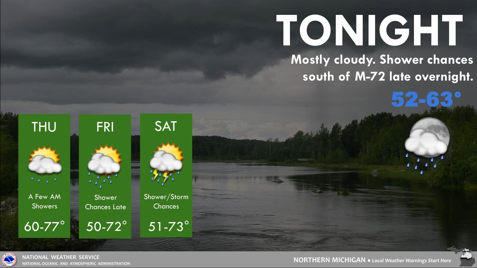
Today and Friday: Surface high pressure with slowly climbing
midlevel heights will bring typical pleasant summertime conditions.
Highs remain in the upper 70s to low 80s today with light southwest
winds. While the majority of the CWA is dry all day, one or two
brief sprinkles tied to a wave tracking across Southern Ontario
could make its way into northern Chippewa County, but showers will
deteriorate over land trying to overcome the low level dry
layer so only one or two localized areas could observe a trace.
No measurable precipitation is expected through Friday.
Saturday and Sunday: A surface low develops over Northern Alberta
and weakens as it moves toward the Canadian east coast. An attached
front will drag across the southern Canadian provinces, delivering
light amounts of moisture to the U.S. Canadian Border. Scattered
showers are expected this Saturday for Michigan`s Eastern Upper
Peninsula. With a disheveled low beginning to break apart, this
front will lose organization as it passes, leaving the majority of
the precipitation closer to the Wisconsin Border. For Chippewa and
Mackinac counties, only a tenth of an inch or less is expected for
most locations. Sunday will likely remain dry but feature increasing
cloud cover with an approaching shortwave.
Monday through Wednesday Outlook: The aforementioned shortwave
trough develops surface low pressure lee of the Canadian Rockies and
moves to the Upper Great Lakes this Monday. Showers and storms will
persist, returning widespread measurable QPF to the CWA for the
first time in several days. Highest rainfall probabilities (40-60%)
remain between a tenth and a quarter inch but embedded convection
will likely change totals as we head closer to early next week.
Surface high pressure appears to build on the backside of this
system as it heads downstream, returning sunny skies and dry weather
through the end of the forecast period.
&&
.AVIATION /00Z TAFS THROUGH 00Z FRIDAY/...
Issued at 1152 PM EDT Wed Jul 22 2026
VFR. Light winds tonight, as high pressure approaches. Dry air
will limit cloud potential. A westerly breeze develops Thursday.
&&
.APX WATCHES/WARNINGS/ADVISORIES...
MI...None.
MARINE...Small Craft Advisory from noon today to 8 PM EDT this evening
for LHZ345-346.
Small Craft Advisory from noon today to 8 PM EDT this evening
for LMZ341-342-344.
&&
$$
DISCUSSION...SJC
AVIATION...JZ
548

ACUS11 KWNS 222344

SWOMCD

SPC MCD 222343

COZ000-230145-


Mesoscale Discussion 1713

NWS Storm Prediction Center Norman OK

0643 PM CDT Wed Jul 22 2026


Areas affected...northeast Colorado


Concerning...Severe potential...Watch unlikely


Valid 222343Z - 230145Z


Probability of Watch Issuance...20 percent


SUMMARY...The potential for a few severe wind gusts is expected to

increase across the discussion area this evening. The areal coverage

of the threat is expected to remain too limited to warrant a watch

issuance.


DISCUSSION...Recent radar trends indicate thunderstorms gradually

increasing in areal coverage across portions of Lincoln and Kit

Carson Counties, to the north of a stalled front. The storms are

developing within the western edge of a more moist and unstable

boundary layer (i.e., MLCAPE up to 1000-2000 J/kg), and within a

zone of stronger east to southeast surface winds. Aided by a gust

front approaching from the west, latest CAM guidance suggests the

potential for upscale growth into a loosely organized complex or

line by 01-02Z.


The current KGLD VWP is sampling a 1-km deep layer of southeast

winds, which will enhance storm-relative inflow into the developing

storms. When coupled with steep low/mid-level lapse rates and

boundary-layer temperature-dewpoint spreads of 30+ degrees, the

setup appears supportive of a few severe wind gusts this evening.


..Mead/Mosier.. 07/22/2026


...Please see www.spc.noaa.gov for graphic product...


ATTN...WFO...GLD...BOU...


LAT...LON   39160355 39870376 40620387 40970359 40870269 39790245

            39030262 38870309 39160355


MOST PROBABLE PEAK WIND GUST...55-70 MPH
221

WGUS53 KAPX 210415

FFWAPX

MIC055-210745-

/O.NEW.KAPX.FF.W.0020.260721T0415Z-260721T0745Z/

/00000.0.ER.000000T0000Z.000000T0000Z.000000T0000Z.OO/


BULLETIN - EAS ACTIVATION REQUESTED

Flash Flood Warning

National Weather Service Gaylord MI

1215 AM EDT Tue Jul 21 2026


The National Weather Service in Gaylord has issued a


* Flash Flood Warning for...

  Central Grand Traverse County in northern Michigan...


* Until 345 AM EDT.


* At 1215 AM EDT, Doppler radar indicated thunderstorms producing

  heavy rain across the warned area. Between 0.5 and 2 inches of

  rain have fallen. Additional rainfall amounts of 1 to 2 inches are

  possible in the warned area. Flash flooding is ongoing or expected

  to begin shortly.


  HAZARD...Flash flooding caused by thunderstorms.


  SOURCE...Radar.


  IMPACT...Flash flooding of small creeks and streams, urban

           areas, highways, streets and underpasses as well as

           other poor drainage and low-lying areas.


* Some locations that will experience flash flooding include...

  Traverse City, Traverse City State Park, Spider Lake, Grawn,

  Williamsburg and Bates.


PRECAUTIONARY/PREPAREDNESS ACTIONS...


Turn around, don`t drown when encountering flooded roads. Most flood

deaths occur in vehicles.


Be especially cautious at night when it is harder to recognize the

dangers of flooding.


Flooding is occurring or is imminent. It is important to know where

you are relative to streams, rivers, or creeks which can become

killers in heavy rains. Campers and hikers should avoid streams or

creeks.


&&


LAT...LON 4482 8550 4476 8539 4466 8538 4462 8549

      4465 8568 4477 8581 4478 8571 4478 8569

      4478 8564 4478 8562 4488 8558 4487 8548


FLASH FLOOD...RADAR INDICATED


$$


Cornish
810

WGUS83 KAPX 181434

FLSAPX


Flood Advisory

National Weather Service Gaylord MI

Issued by National Weather Service Marquette MI

1034 AM EDT Sat Jul 18 2026


MIC007-119-181444-

/O.EXP.KAPX.FA.Y.0028.000000T0000Z-260718T1430Z/

/00000.N.ER.000000T0000Z.000000T0000Z.000000T0000Z.OO/

Alpena MI-Montmorency MI-

1034 AM EDT Sat Jul 18 2026


...FLOOD ADVISORY HAS EXPIRED...


The Flood Advisory has expired for a portion of northern Michigan,

including the following areas, Alpena and Montmorency.


Flood waters have receded. Flooding is no longer expected to pose a

threat. Please continue to heed remaining road closures.


&&


LAT...LON 4511 8411 4511 8331 4502 8325 4504 8335

      4506 8337 4507 8337 4505 8344 4502 8344

      4499 8341 4496 8344 4494 8343 4492 8340

      4491 8339 4488 8331 4486 8332 4486 8377

      4502 8410


$$


NJL