A More Detailed Look at the Mississippi River Flood of 1965
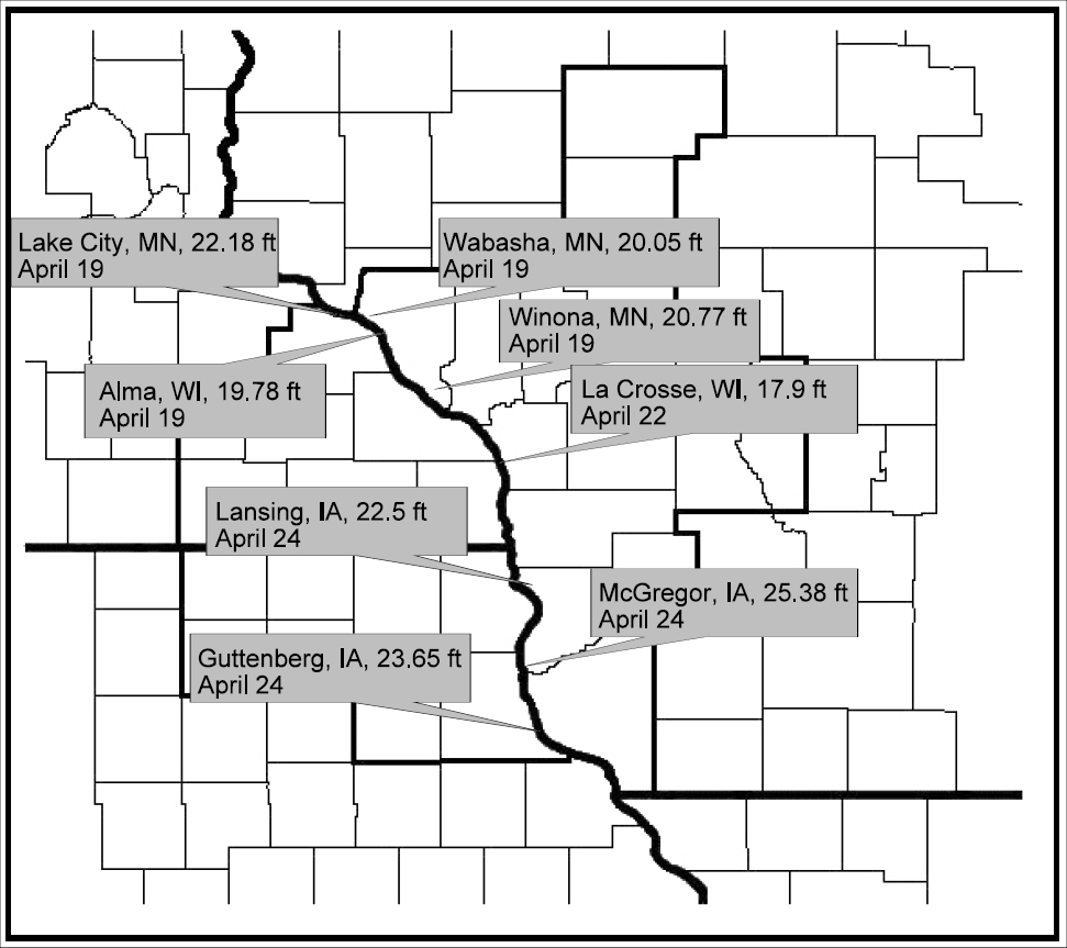
| Record snowmelt floods affected residents along the Mississippi River from about 100 miles north of Minneapolis, MN to Hannibal, MO from mid April through early May. Many of the record crests from this flood still stand today. This includes: 22.18 feet at Lake City, MN on April 19th; 20.05 feet at Wabasha, MN on April 19th; 20.77 feet at Winona, MN on April 19th; 17.90 feet at La Crosse, WI on April 21st; 22.50 feet at Lansing, IA on April 24th; and 25.38 feet at McGregor, IA on April 24th). The Mississippi River was above flood stage anywhere from 15 to 29 days in these locations. More details on the flooding (including hydrographs) can be found for each of the aforementioned sites below. |
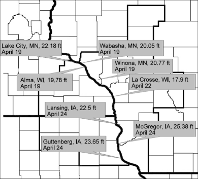
Record Crests from the Mississippi River Flood of 1965 |
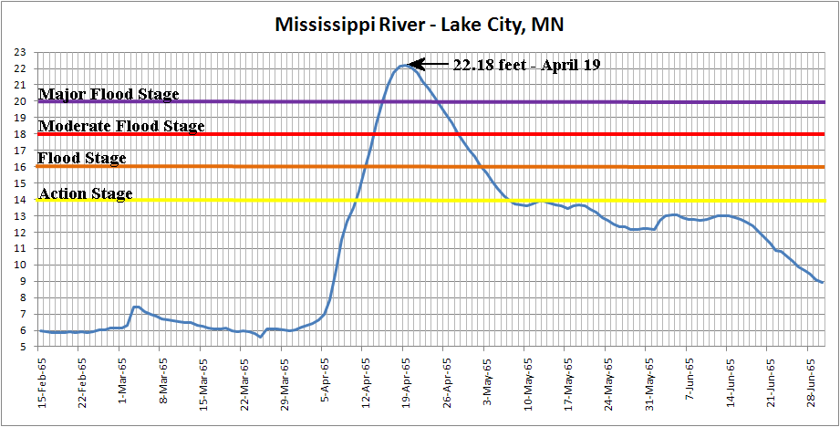
Lake City, MN
| At Lake City, Minnesota, the Mississippi River went above its flood stage (16 feet) on April 12th. The river reached moderate flood stage (18 feet) late on April 13th and major flood stage (20 feet) on April 15th. The river crested at a record 22.18 feet on April 19th. This surpassed the previous record of 19.17 feet on April 18, 1952. The river then fell below major flood stage late on April 24th and moderate flood stage on April 28th. The river finally fell below flood stage on May 2nd. This was 21 days after the river flooding began. The river then lingered within two to three feet of flood stage through mid June. |
Lake City, MN hydrograph constructed
from 8 AM river stages
|
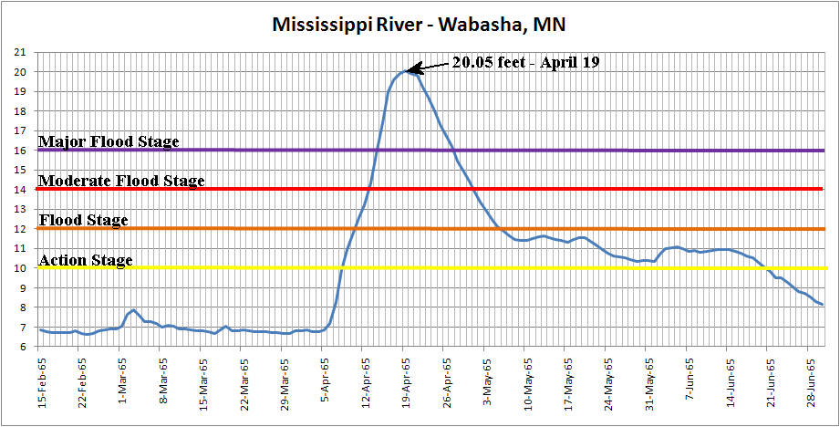
Wabasha, MN
| At Wabasha, Minnesota, the Mississippi River went above its flood stage (12 feet) on April 10th. The river reached moderate flood stage (14 feet) early on April 13th and major flood stage (16 feet) on April 14th. The river crested at a record 20.05 feet on April 19th. This surpassed the previous record of 16.71 feet on April 18, 1952. The river then fell below major flood stage on April 27th and moderate flood stage early on May 1st. The river finally fell below flood stage late on May 5th. This was 26 days after the river flooding began. The river then lingered within two feet of flood stage through mid June. |
Wabasha, MN hydrograph constructed
from 8 AM river stages
|
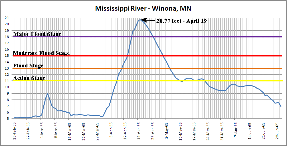
Winona, MN
| At Winona, Minnesota, the Mississippi River went above its flood stage (13 feet) on April 10th. The river reached moderate flood stage (15 feet) on April 13th and major flood stage (18 feet) on April 16th. The river crested at a record 20.77 feet on April 19th. This surpassed the previous record of 17.91 feet on April 20, 1952. The river then fell below major flood stage on April 26th and moderate flood stage on May 1st. The river finally fell below flood stage early on May 5th. This was 26 days after the river flooding began. The river then lingered within two to three feet of flood stage through mid June. |
Winona, MN hydrograph constructed
from 8 AM river stages
|
Flood predictions from the U.S. Weather Bureau and local actions taken based from Winona Daily News articles:
- March 19th: Joseph H. Strub Jr., hydrologist at the U.S. Weather Bureau said that "if additional rainfall occurs, crests at Winona will be near those of 1952."
- March 31st: Joseph H. Strub Jr., hydrologist at the U.S. Weather Bureau said that "heavy April rains may mean a record crest for Winona."
- April 7th: Joseph H. Strub Jr., hydrologist at the U.S. Weather Bureau predicted an 18-foot or higher crest.
- April 8th: Winona city officials met that morning and came up with a plan to throw up an 18-foot temporary dike around the city's vulnerable east side and ordered high-volume pumps to handle overloads at the sewage treatment plant. The same day, Joseph H. Strub Jr., hydrologist at the U.S. Weather Bureau revised his flood predictions and now the river was expected to crest at nearly 21 feet (nine feet over flood stage, and nearly three feet higher than the "hundred year" flood of 1952) or . That night Mayor Rudy Ellings called a meeting of contractors and challenged them to erect a dike. They marked out four sectors - from lock and dam 5A on Prairie Island to Mankato Avenue. Within 24 hours, construction had begun.
- From April 9th through April 19th: As many as 5,000 people worked to build, and later monitor, the temporary dikes. They filled 1.3 million sand bags and worked round the clock for 10 days, using almost 300 trucks, 25 to 30 bulldozers, 8 earth movers, 10 drag lines and a dozen backhoes.
- April 19th: Early in the morning, William Fitzgerald collapsed and died after delivering a load of sand bags. He was 35 years old and he had operated Hill Top Tavern near Stockton. This was Winona's only fatality contributed to the flood. The Mississippi River at Winona, MN crested at 20.77 feet. The dikes worked, and Winona remained, for the most part, dry.
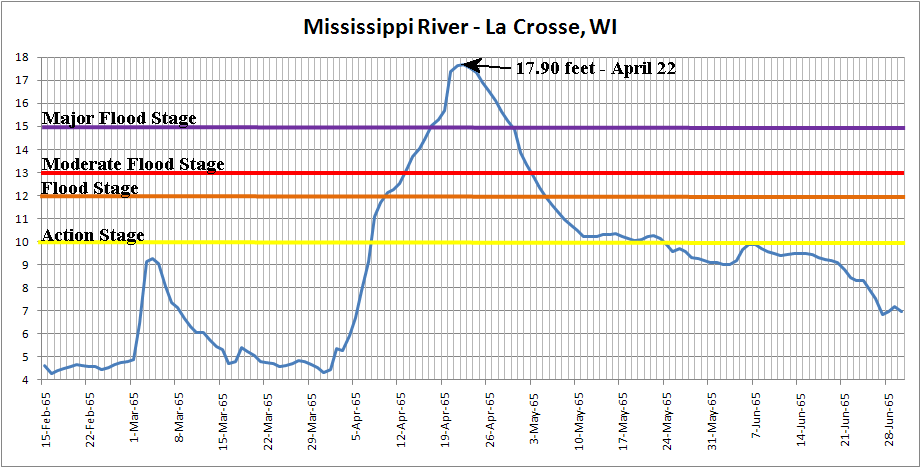
La Crosse, WI
| At La Crosse, Wisconsin, the Mississippi River went above its flood stage (12 feet) early on April 10th. The river reached moderate flood stage (13 feet) on April 13th and major flood stage (15 feet) on April 17th. The river crested at a record 17.90 feet on April 22nd. This surpassed the previous record of 15.30 feet on April 20, 1952. The river then fell below major flood stage late on April 29th and moderate flood stage early on May 3rd. The river finally fell below flood stage early on May 5th. This was 26 days after the river flooding began. The river then lingered within two to three feet of flood stage through mid June. |
La Crosse, WI hydrograph constructed
from 8 AM river stages
|
Local actions and flooding based from La Crosse Tribune articles:
- April 6: The Minneapolis Weather Bureau predicts the Mississippi River will crest at 16 feet on April 21 in La Crosse.
- April 7: Ice jams smash into the dam at Dresbach, MN. The gates are opened wide to let the ice through before more damage is done.
- April 8: Wisconsin Governor Warren Knowles declares a state of emergency in the La Crosse area and the Common Council authorizes what it calls a "blank check" for the city's flood-fighting effort.
- April 9: A tug boat breaks up a West Channel ice jam that had been threatening the bridge and natural gas pipe lines. The Minneapolis Weather Bureau revises their crest prediction, saying the river might reach 17.5 to 18 feet.
- April 10: As the river surpasses flood stage (12 feet) during the early morning hours, sand bags and plastic sheeting are placed along the water front.
- April 11: Evacuations pick up on Green and Barron islands.
- April 12: The Milwaukee Road and Burlington Northern end rail service to La Crosse. City crews build dikes on the North Side and along Highway 53. The Minneapolis Weather Bureau crest prediction is revised to 18 feet.
- April 13: Emergency traffic control is set up on French Island, and the National Guardsmen are added to the dike-building effort.
- April 14: President Lyndon Johnson flies over La Crosse while inspecting flood and tornado damage in the Midwest. La Crosse Mayor Milo Knutson warns residents newly built dikes might not hold.
- April 15: Water follows a Milwaukee Road track along the Black River and floods an area near the Causeway. Lang Drive and Gillette Street are closed. National Guardsmen are ordered to patrol the dikes 24 hours a day.
- April 16: An early-morning fire destroys the studios of WKBT-TV and WKBH-Radio. The city ties its previous high-water record of 15.30 feet set in 1952 (April 20). Portions of the Causeway are under water, and the Coast Guard begins patrolling to discourage river traffic and to protect property. A La Crescent man, 55-year old Roland Fischer, drowns while trying to ferry fellow employees to the Northern States Power Company plant.
- April 17: The Clinton Street Bridge is closed, and businesses along the Causeway are surrounded by water. The dikes are holding, but there is seepage.
- April 18: Many residents observe Easter, but National Guardsmen patrolling the dikes are issued weapons because of vandalism reports. Crews begin adding another 2 feet to the Highway 53 dike.
- April 19: A North Side dike breaks and water pours in near the Black River, flooding 25 homes on the south end of the North Side. A washout is spotted beneath a Texas Oil Company gasoline storage tank along the Black River. The tank, containing 107,000 gallons of gasoline, holds on. Two runways at the airport are flooded. Both French Island and the North Side lose telephone service.
- April 20: The river crests at what is then believed to be 17.70 feet. This crest was raised to 17.90 feet on May 1st. The river stays near its crest for three days. The La Crosse Weather Bureau is moved into the telephone company's downtown building. Another row of sandbags is placed on the city's 4.8 miles of dikes, which are credited with keeping most of the North Side dry. A new mayor, Warren Loveland, is sworn in and says flood-control operations won't be changed.
- April 22: A corner of the W. A. Roosevelt Company building at 230 N. Front Street sags when a footing washes out. Water pressure under the building causes the basement floor to explode.
- April 24: City officials meet and begin to discuss cleanup operations.
- April 25: The National Guard stops patrolling the dikes.
- April 27: City crews begin removing some dikes.
- April 28: Lang Drive is open again. City officials estimate nearly $1.2 million has been spent fighting the flood, even though thousands of volunteers helped fill sandbags.
- April 30: Highway 35 and Causeway are open. The river (14.86 feet at 8 AM) is still above flood stage, but residents were moving back into their homes, and businesses along the Causeway are being cleaned and prepared to open.
- May 1: The river's crest was revised upward. High-water marks inside a building at Front and Mount Vernon Streets, where a gauge has provided flood readings, show the water reached 17.90 feet.
- May 5: Mississippi River finally falls below flood stage (12 feet).
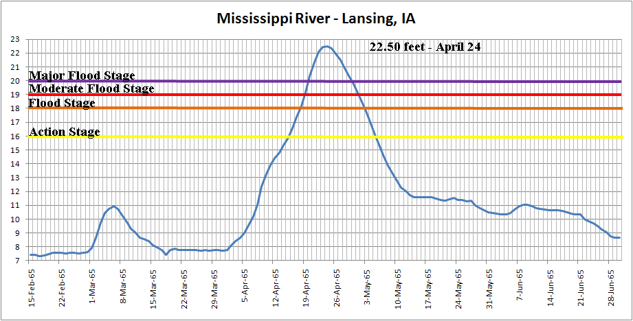
Lansing, IA
| At Lansing, Iowa, the Mississippi River went above its flood stage (18 feet) on April 18th. The river reached moderate flood stage (19 feet) on April 19th and major flood stage (20 feet) early on April 20th. The river crested at a record 22.50 feet on April 24th. This surpassed the previous record of 19.90 feet on June 20, 1880. The river then fell below major flood stage late on April 29th and moderate flood stage on May 1st. The river finally fell below flood stage late on May 2nd. This was 15 days after the river flooding began. |
Lansing, IA hydrograph constructed
from 8 AM river stages
|
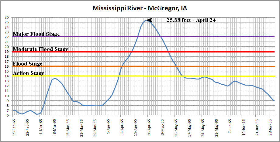
McGregor, IA
| At McGregor, Iowa, the Mississippi River went above its flood stage (16 feet) on April 12th. The river reached moderate flood stage (19 feet) on April 17th and major flood stage (22 feet) on April 20th. The river crested at a record 25.38 feet on April 24th. This surpassed the previous record of 21.00 feet on June 20, 1880. The river then fell below major flood stage on May 2nd and moderate flood stage on May 6th. The river finally fell below flood stage late on May 10th. This was 29 days after the river flooding began. The river then lingered within two to three feet of flood stage through mid June. |
McGregor, IA hydrograph constructed
from 8 AM river stages
|


 Weather Story
 Weather Map
 Local Radar