| Main Page | Details on the Flooding | Why did it occur? | Other Mississippi River Floods |
| Media Accounts | Personal Accounts | Flooding Pictures | Acknowledgements |
Several factors contributed to this record flood:
| Temperatures from November 28th through Christmas of 1964 ranged from 3 to 7 degrees below normal across the region. At the same time, there was little, if any, snow on the ground. For example at La Crosse, WI, there was one inch or less (no snow was on the ground from December 5th through December 19th) through the aforementioned time period. At the same time, temperatures averaged 17.1degrees which was 6.3 degrees below the normal of 23.4 degrees. The combination of the below normal temperatures and lack of snow allowed the frost to penetrate deep into the ground. With the winter of 1964-65 being the 7th coldest of the 20th century in Minnesota (average temperature of 6.1 degrees which was 5.5 degrees colder than the 1901-2000 average of 11.6 degrees) and the 17th coldest of the 20th century in Wisconsin (average temperature of 13.2 degrees which was 3.4 degrees colder than the 1901-2000 average of 16.6 degrees), the frost depth remained abnormally deep right into early April of 1965. |
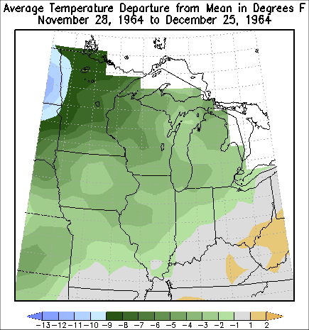
Temperature Departure from Normal from
November 28 through December 25, 1964 |
| During March of 1965, a series of winter storms (March 1-3, March 10-12, March 17-18, and March 27-29) produced abundant snow across much of Minnesota and parts of Wisconsin. The hardest hit areas were the river basins of the Minnesota (March snowfall totals ranged from 14.1 inches at Tyler, MN to 58.0 inches at Bird Island - most of the basin saw snow amounts ranging from 30 to 40 inches), St. Croix (March snowfall totals ranged from 24.0 inches at Grantsburg, WI to 33.0 inches at Minong, WI), and Chippewa (March snowfall totals ranged from 16.3 inches at Baldwin, WI to 33.0 inches at Spring Valley, WI). This is very significant because the eventual snow melt from these three large river basins would flow into the Mississippi River just north of the National Weather Service La Crosse, WI Hydrologic Service area. Locally, March snowfall totals ranged from 8.0 inches at Winona, MN to 23.5 inches at Hatfield, WI (most locations saw anywhere from 10 to 20 inches). The eventual snow melt would produce flooding along the Cedar, Root, Black, and South Fork Zumbro rivers. This helped keep the Mississippi River stages high until they could be further enhanced by flows from the Minnesota, St. Croix, and Chippewa rivers. |
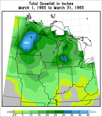 Total Snowfall for March 1965 |
| March of 1965 was one of the coldest Marches ever recorded in both Minnesota and Wisconsin. Minnesota had an average temperature of 14.8 degrees. This was 11.2 degrees colder than the 1901-2000 average of 26.0 degrees. It was their second coldest March. Only 1899 was colder with an average temperature of 13.3 degrees. Wisconsin had an average temperature of 21.4 degrees. This was 7.5 degrees colder than the 1901-2000 average of 28.9 degrees. This was the fifth coldest March of the 20th century and sixth coldest March ever recorded (these records date back to 1895). These colder than average temperature prevented the gradual melting and runoff of the snowpack. | 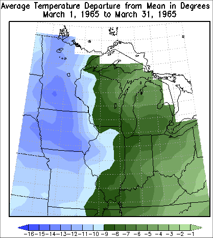
March 1965 Temperature
Departures from Normal
|
| Between April 1 and April 15 of 1965, 2.50 to 3.50 inches of rain fell across the region. Normally the rain would sink into the ground. However, with the frozen ground, the rain had no place to go other than into streams and rivers. In addition, the rain melted the abnormally deep snow pack, resulting in even more water. Therefore, streams and rivers rose quickly, causing the Mississippi River to reach record flood stages by mid April of 1965. | 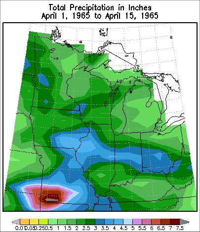 Precipitation from April 1 through April 15, 1965 |


 Weather Story
 Weather Map
 Local Radar