Overview
|
Very heavy rain on Saturday and Sunday, June 7-8th 2008, resulted in record flooding across a large portion of the region, along with a few bouts of hail, damaging winds, and tornadoes. On Saturday the 7th, a significant return of moisture and warmth during the overnight hours Friday led to the development of a cluster of thunderstorms which moved out of southern Minnesota into western Wisconsin Saturday morning. These storms posed a small hail risk, with rainfall amounts around an inch as they moved along and north of the Interstate 90 corridor through noon. During the early afternoon hours on Saturday, the remnants of these storms encountered greater instability as warmth and moisture continued to feed into the area on a very strong southerly flow over Iowa. A severe thunderstorm developed over Monroe county early in the afternoon, and moved east along Interstate 90 with an attendant threat of tornadoes, damaging winds, and large hail. This was the first of what would be numerous supercell thunderstorms which then developed over much of the area of south of Interstate 90 through the rest of the afternoon into the early evening. All of these storms exhibited strong circulations on radar, with numerous reports of rotating wall clouds, funnel clouds, and brief tornadoes. Given the extreme amounts of moisture, these storms also exhibited a very high rainfall rate, which led to 1 to 2 inch rainfall amounts in an hour or so. As these storms congealed into a larger scale line of thunderstorms, the repeat (or training) of these storms led to flash flooding conditions through the evening and overnight. For further information on the tornadoes, read the tornado summary for that day. On Sunday the 8th, the warm front was lingering across the region, but a cold front was quickly tracking east out of the northern Plains. Showers and storms would redevelop during the day in the vicinity of the warm front, while a line of storms developed out ahead of the cold front, with these tracking across the region Sunday night. Again, copious amounts of moisture lead to periods of heavy rain, while a few storms produced damaging winds. The severe weather activity, aside from the heavy rain, was much less locally compared to Saturday. |
|
Flooding
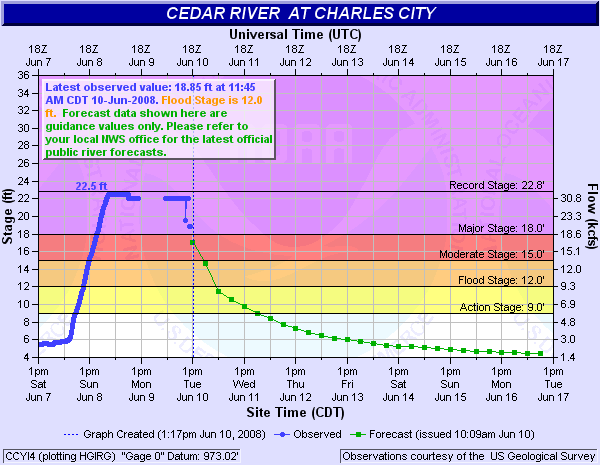
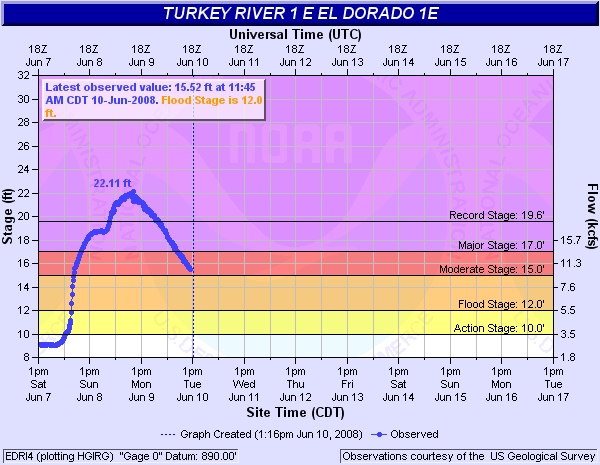
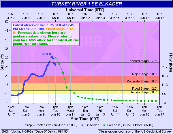
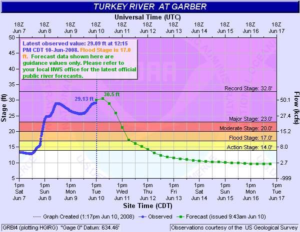
The hydrographs below are "snapshots" of how the rivers responded to the rainfall and runoff, along with the forecast at that given time. These hydrographs are from either late morning or early afternoon of Tuesday, June 10th.
| Upper Iowa River at Decorah | |
 |
Historical Crests:
|
| Upper Iowa River at Dorchester | |
 |
Historical Crests:
|
| Cedar River at Charles City | |
 |
Historical Crests:
|
| Turkey River at El Dorado | |
 |
Historical Crests:
Flood Categories:
|
| Turkey River at Elkader | |
 |
Historical Crests:
|
| Turkey River at Garber | |
 |
Historical Crests:
|
| Kickapoo River at Ontario | |
 |
Historical Crests:
|
| Kickapoo River at La Farge | |
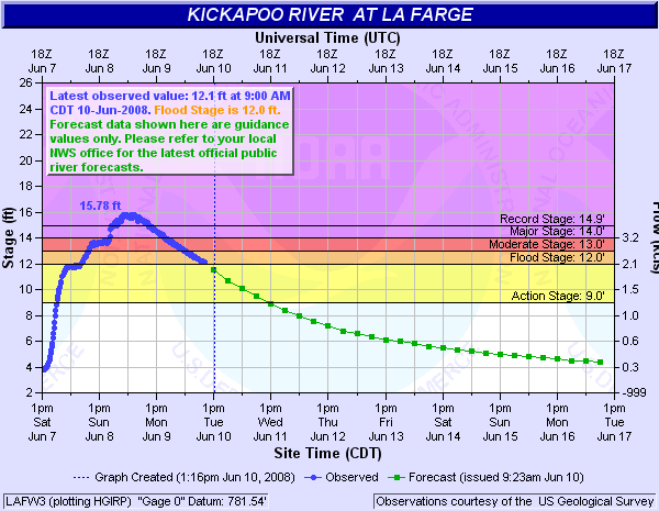 |
Historical Crests:
|
| Kickapoo River at Viola | |
 |
Historical Crests:
|
| Kickapoo River at Readstown | |
 |
Historical Crests:
|
| Kickapoo River at Soldiers Grove | |
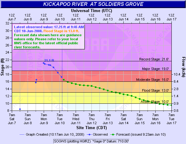 |
Historical Crests:
|
| Kickapoo River at Gays Mills | |
 |
Historical Crests:
|
| Kickapoo River at Steuben | |
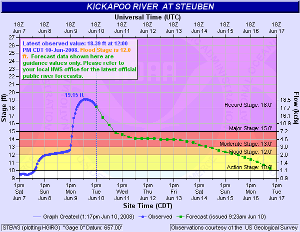 |
Historical Crests:
|
County Impacts:
Allamakee County, Iowa
Chickasaw County, Iowa
Clayton County, Iowa
Fayette County, Iowa
Floyd County, Iowa
Howard County, Iowa
Mitchell County, Iowa
Winneshiek County, Iowa
Fillmore County, Minnesota
Houston County, Minnesota
Mower County, Minnesota
Adams County, Wisconsin
Crawford County, Wisconsin
Grant County, Wisconsin
Juneau County, Wisconsin
Richland County, Wisconsin
Vernon County, Wisconsin
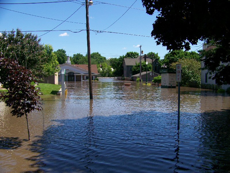
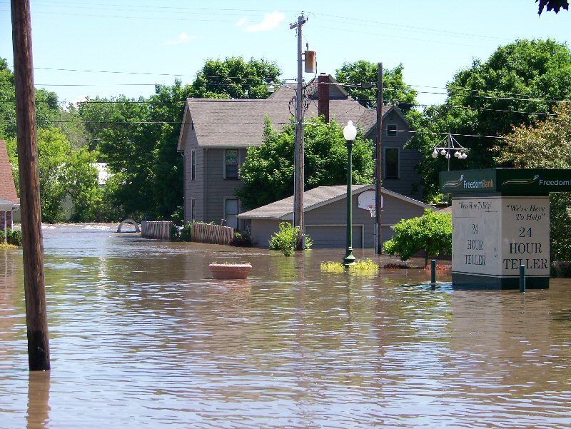
Photos:
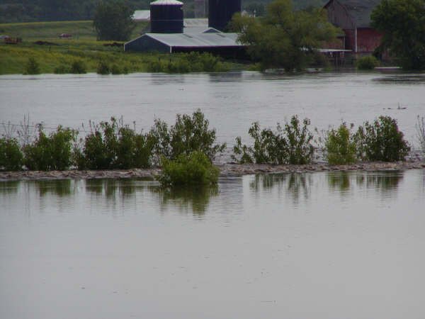
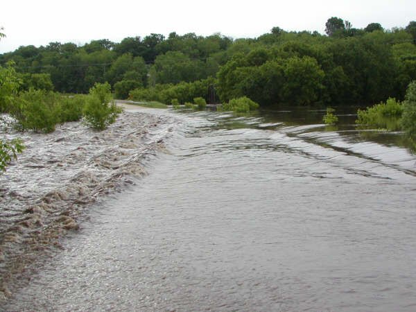
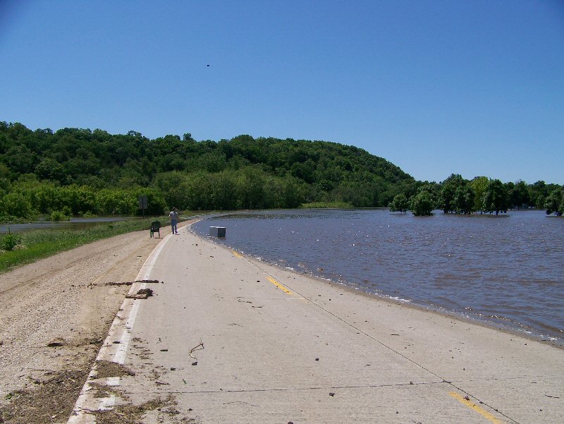
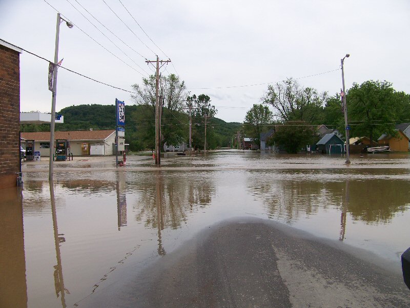
Eldorado, IA
 |
 |
 |
 |
 |
 |
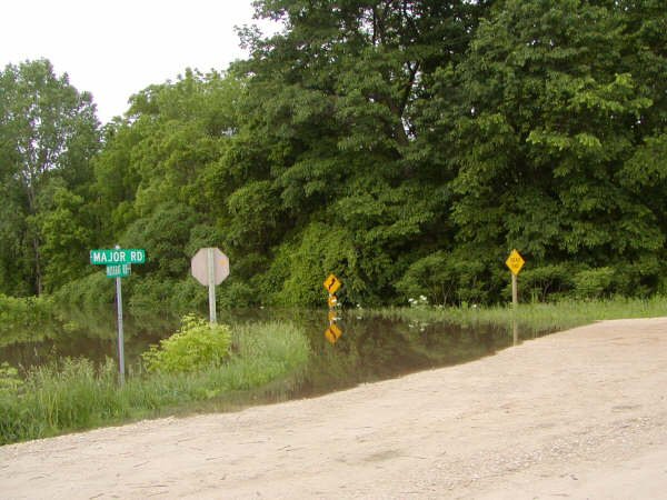 |
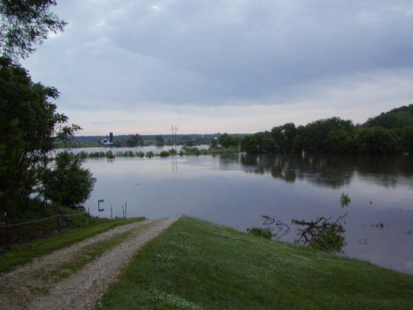
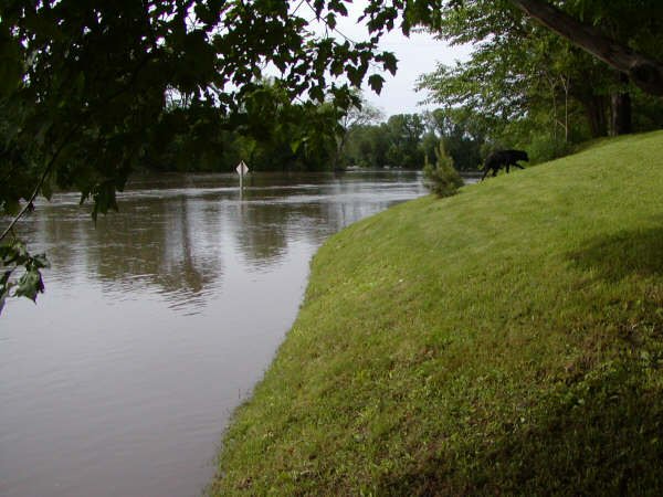
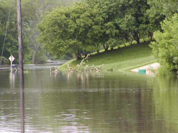
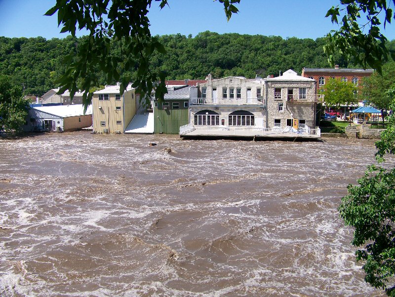
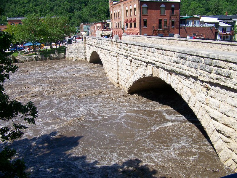
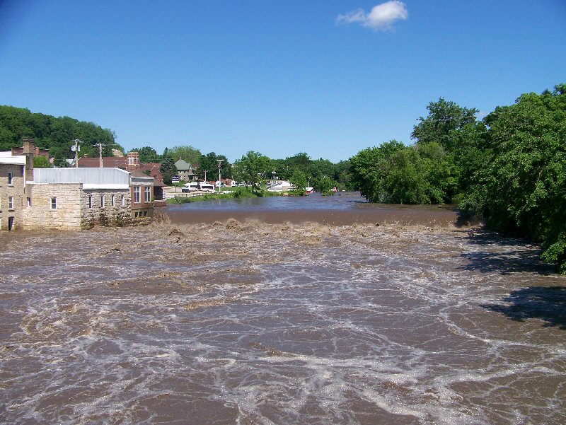
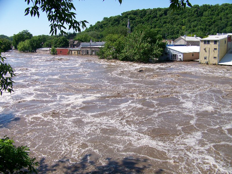
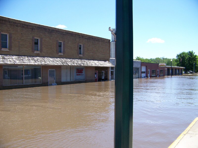
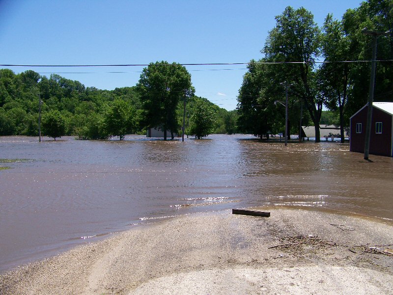
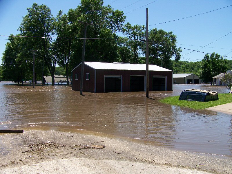
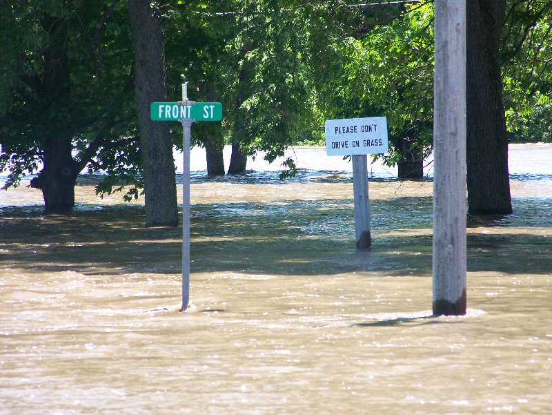
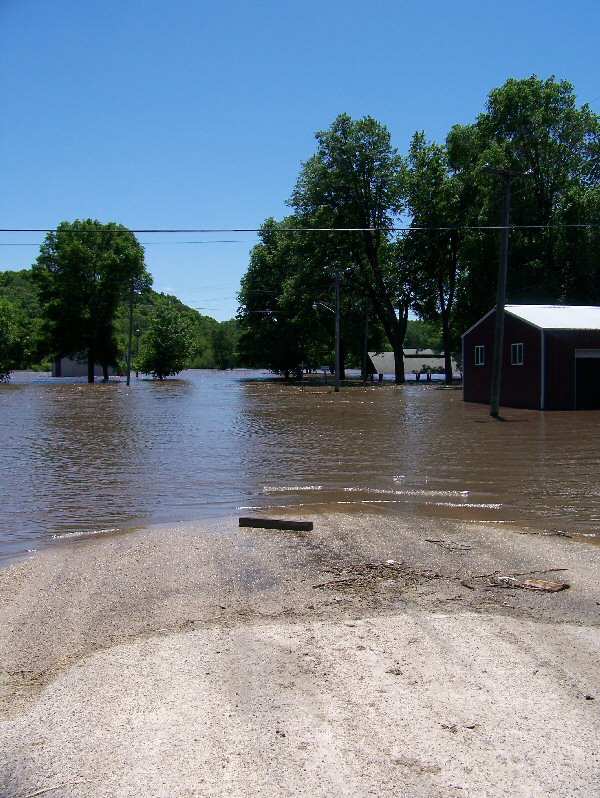
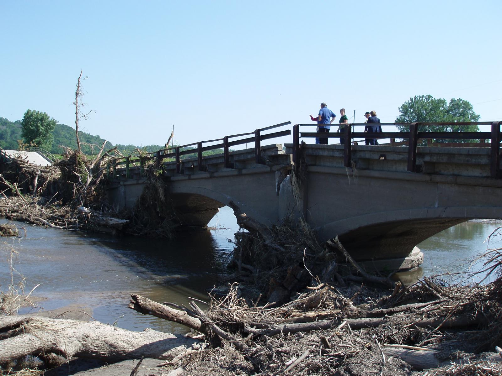
Elkader, IA
 |
 |
 |
 |
 |
 |
 |
 |
 |
 |
 |
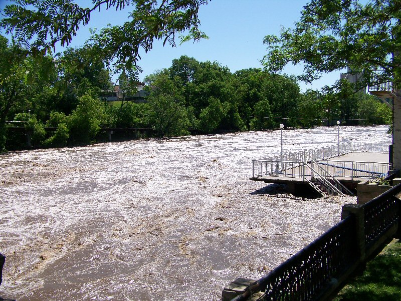
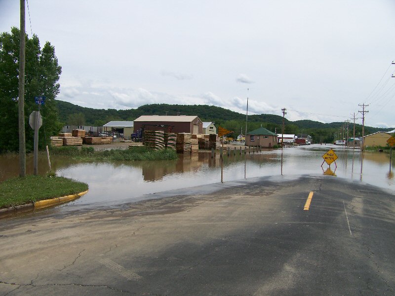
Garber, IA
 |
 |
 |
 |
 |
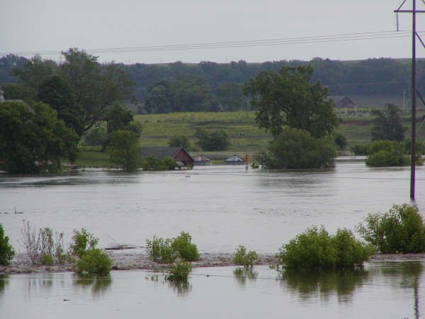
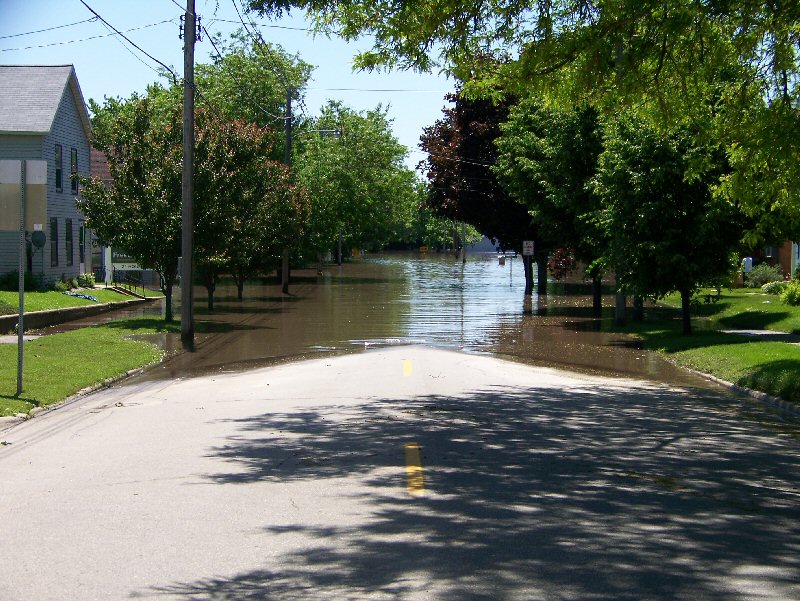
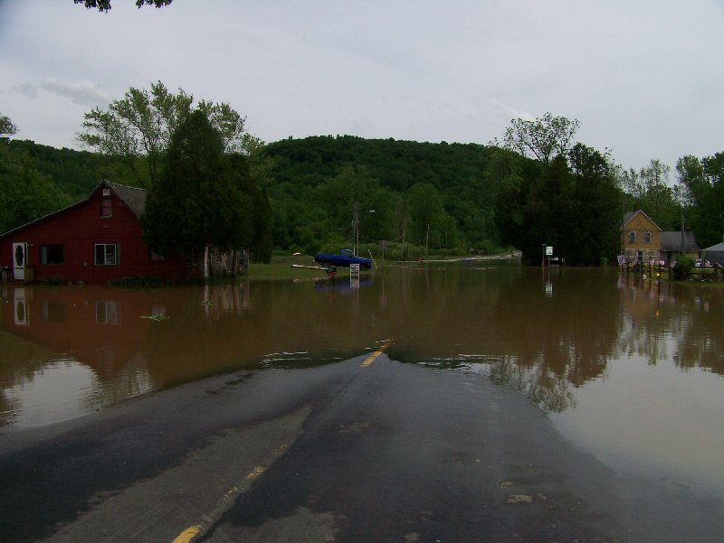
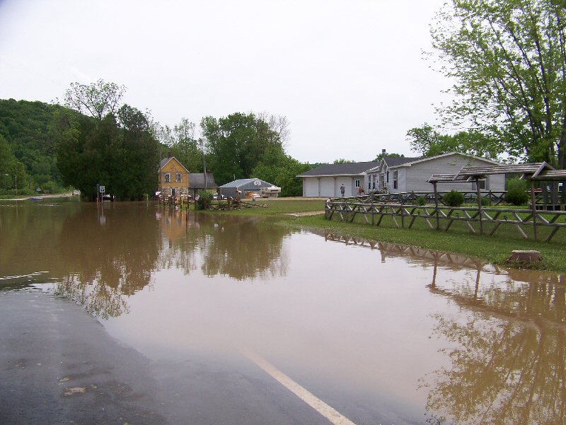
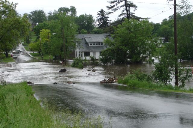
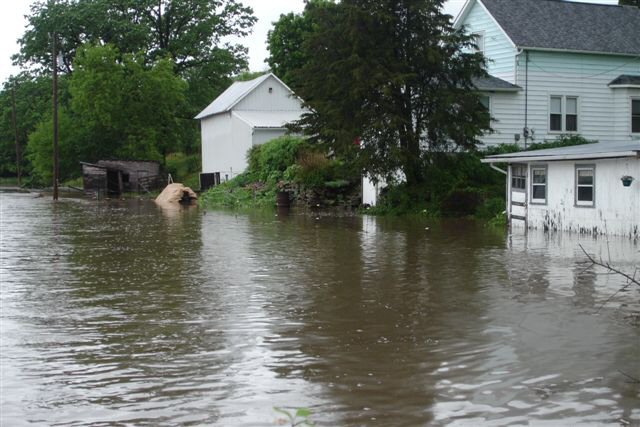
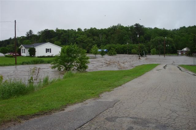
La Farge, WI
 |
 |
 |
 |
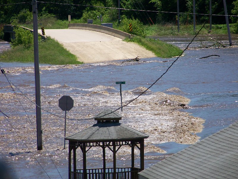
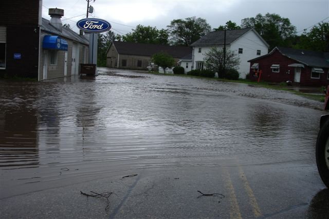
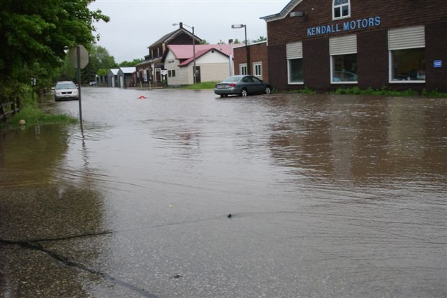
Kendall, WI
 |
 |
 |
 |
 |
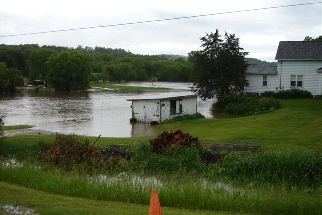 |
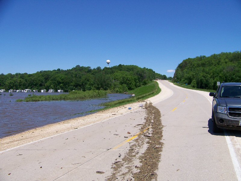
Miscellaneous
 |
 |
 |
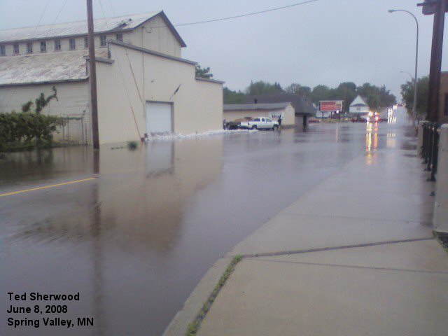 |
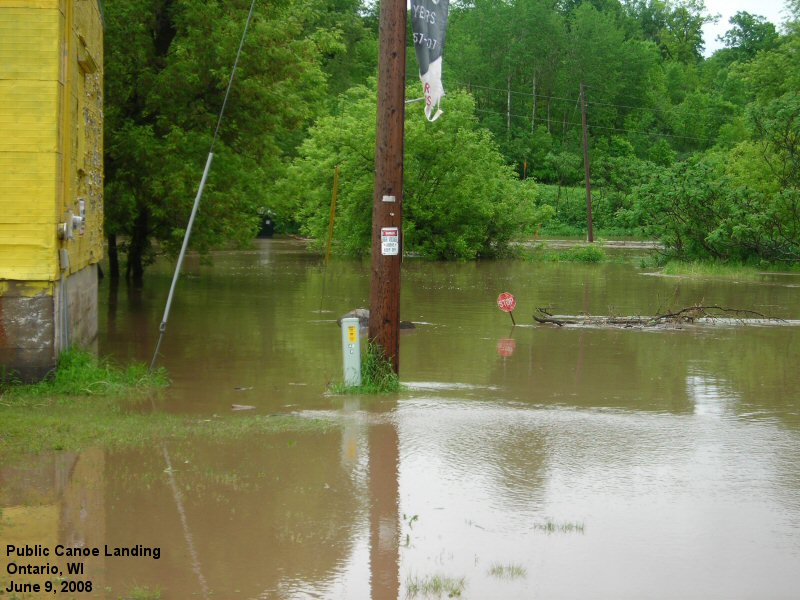
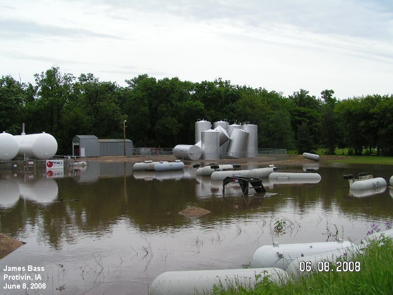
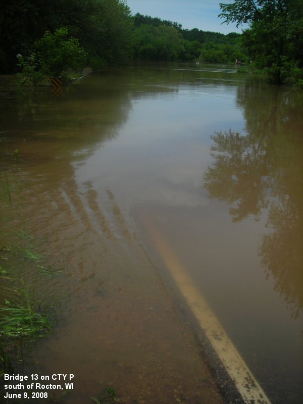
| Ontario, WI | Protovin, IA | Rocton, WI | Spring Valley, MN |
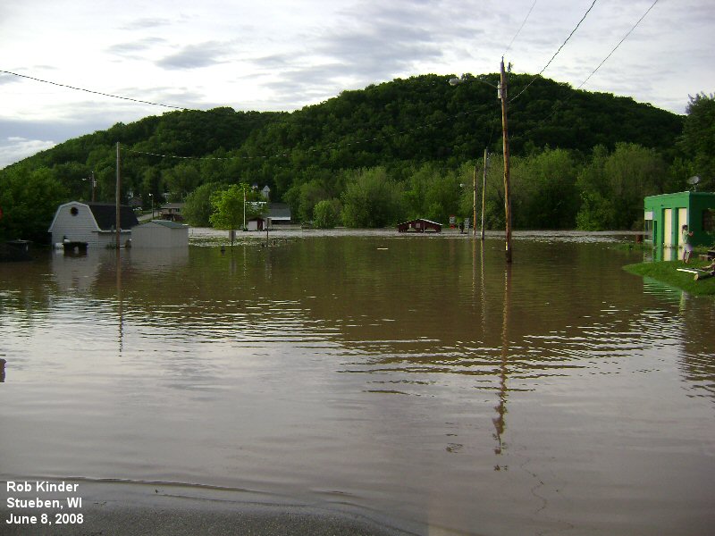 |
 |
 |
|
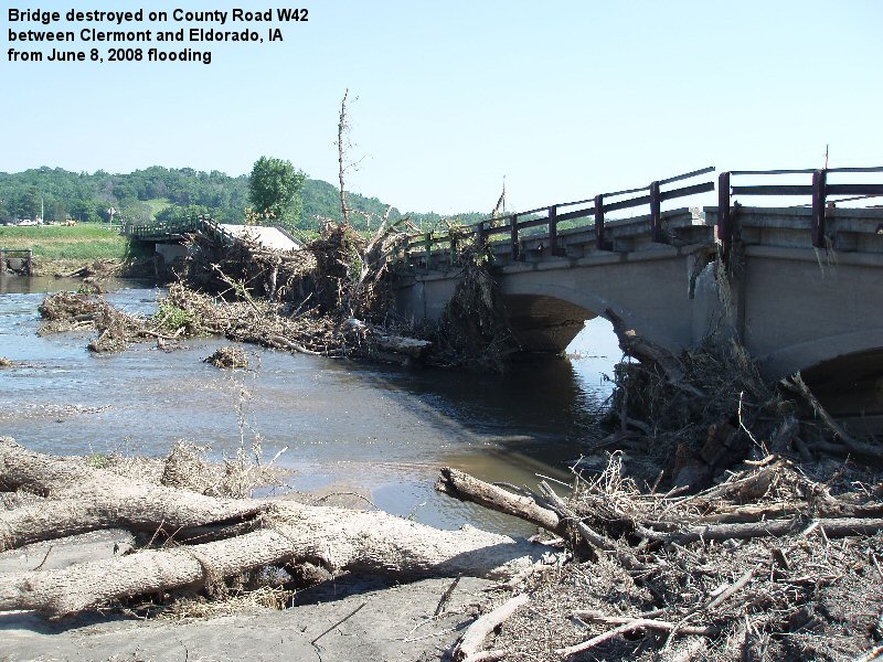
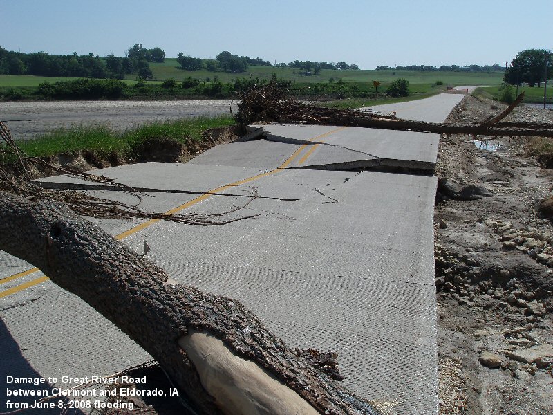
| Steuben, WI | Damage between Clermont and Eldorado, IA | Damage between Clermont and Eldorado, IA |
Storm Reports from June 7, 2008
PRELIMINARY LOCAL STORM REPORT...CORRECTED
NATIONAL WEATHER SERVICE LA CROSSE WI
249 PM CDT MON JUN 09 2008

..TIME...   ...EVENT...      ...CITY LOCATION...     ...LAT.LON...
..DATE...   ....MAG....      ..COUNTY LOCATION..ST.. ...SOURCE....
            ..REMARKS..

0942 AM     HAIL             NELSON                  44.42N 92.00W
06/07/2008  M0.75 INCH       BUFFALO            WI   LAW ENFORCEMENT

            PENNY SIZE HAIL

1155 AM     HAIL             3 SE SPARTA             43.91N 90.77W
06/07/2008  E1.00 INCH       MONROE             WI   TRAINED SPOTTER

1245 PM     TSTM WND GST     5 S KENDALL             43.72N 90.37W
06/07/2008  E50.00 MPH       VERNON             WI   AMATEUR RADIO

1248 PM     TSTM WND GST     4 S KENDALL             43.74N 90.37W
06/07/2008  E60.00 MPH       MONROE             WI   TRAINED SPOTTER

1249 PM     TSTM WND GST     2 W ELROY               43.74N 90.31W
06/07/2008  M60.00 MPH       MONROE             WI   AMATEUR RADIO

0116 PM     TSTM WND DMG     3 SE KENDALL            43.76N 90.33W
06/07/2008                   MONROE             WI   AMATEUR RADIO

            TREE BLOCKING ROAD AND ROAD WASHOUT ON MISSOURI ROAD NEAR
            COUNTY V.

0116 PM     TSTM WND DMG     KENDALL                 43.79N 90.37W
06/07/2008                   MONROE             WI   AMATEUR RADIO

            MINOR STRUCTURAL DAMAGE TO HOUSE IN KENDALL. POWER LINES
            DOWN. POSSIBLE DAMAGE TO AN AUTOMOBILE IN KENDALL.

0116 PM     TSTM WND GST     10 S ADAMS              43.81N 89.82W
06/07/2008  E0.00 MPH        ADAMS              WI   AMATEUR RADIO

            60 MPH WIND GUST AT HIGHWAY 82 AND 13. ONE HALF INCH HAIL
            ALSO REPORTED.

0121 PM     HAIL             1 W ADAMS               43.96N 89.84W
06/07/2008  E0.88 INCH       ADAMS              WI   AMATEUR RADIO

            NICKEL HAIL JUST WEST OF ADAMS/FRIENDSHIP

0137 PM     HEAVY RAIN       ONTARIO                 43.72N 90.59W
06/07/2008  M3.60 INCH       VERNON             WI   CO-OP OBSERVER

0143 PM     TSTM WND GST     15 SE MAUSTON           43.65N 89.87W
06/07/2008  E0.00 MPH        JUNEAU             WI   EMERGENCY MNGR

            60 MPH WINDS AT THE INTERSTION OF HIGHWAY 13 AND COUNTY
            Q.

0143 PM     TSTM WND GST     15 SE MAUSTON           43.65N 89.87W
06/07/2008  E60.00 MPH       JUNEAU             WI   EMERGENCY MNGR

            60 MPH WIND AT INTERSECTION OF HIGH 13 AND COUNTY Q

0152 PM     TORNADO          2 S WAUZEKA             43.06N 90.90W
06/07/2008                   GRANT              WI   LAW ENFORCEMENT

            BRIEF EF0 TORNADO TOUCHDOWN ON DNR LAND IN THE NORTHERN
            PART OF GRANT COUNTY SOUTH OF WAUZEKA. THERE WERE ALSO
            NUMEROUS FUNNELS REPORTED FROM THIS SUPERCELL TORNADO
            TOUCHDOWN THROUGH BOSCOBEL AND MUSCODA ALONG THE
            WISCONSIN RIVER AS THE STORM TRACKED NORTHEAST. NO OTHER
            CONFIRMED TORNADOES OCCURRED HOWEVER. THIS REPORT
            REPLACES THE UNCONFIRMED TORNADO REPORT 10ESE BOSCOBEL AT
            205 PM.

0154 PM     TSTM WND GST     5 W BIG SPRING          43.67N 89.73W
06/07/2008  E60.00 MPH       ADAMS              WI   AMATEUR RADIO

            LARGE TREES DOWN ON HIGHWAY 23

0205 PM     TORNADO          10 ESE BOSCOBEL         43.08N 90.52W
06/07/2008                   GRANT              WI   LAW ENFORCEMENT

            TORNADO ON GROUND NEAR WOODMAN

0210 PM     FUNNEL CLOUD     BOSCOBEL                43.14N 90.70W
06/07/2008                   GRANT              WI   AMATEUR RADIO

0215 PM     TSTM WND GST     BOSCOBEL                43.14N 90.70W
06/07/2008  E50.00 MPH       GRANT              WI   LAW ENFORCEMENT

0215 PM     HAIL             4 SW ALTA VISTA         43.15N 92.47W
06/07/2008  M0.50 INCH       CHICKASAW          IA   LAW ENFORCEMENT

0302 PM     FUNNEL CLOUD     1 W NORTH WASHINGTON    43.12N 92.43W
06/07/2008                   CHICKASAW          IA   LAW ENFORCEMENT

0325 PM     HAIL             4 SW ALTA VISTA         43.15N 92.47W
06/07/2008  E0.50 INCH       CHICKASAW          IA   LAW ENFORCEMENT

0336 PM     FUNNEL CLOUD     2 W RACINE              43.78N 92.52W
06/07/2008                   MOWER              MN   TRAINED SPOTTER

0411 PM     HAIL             UTICA                   43.98N 91.95W
06/07/2008  E0.50 INCH       WINONA             MN   TRAINED SPOTTER

0438 PM     HAIL             WILSON                  43.95N 91.70W
06/07/2008  E0.50 INCH       WINONA             MN   TRAINED SPOTTER

0438 PM     FLOOD            WINONA                  44.05N 91.66W
06/07/2008                   WINONA             MN   EMERGENCY MNGR

            STREET FLOODING IN WINONA

0445 PM     TORNADO          2 NW STACYVILLE         43.46N 92.81W
06/07/2008                   MITCHELL           IA   LAW ENFORCEMENT

            CONFIRMED EF0 TORNADO WITH NO DAMAGE FOUND. PHOTOGRAPHED
            BY STACEYVILLE PD CHIEF. TORNADO TIME WINDOW 445 PM TO
            450 PM.

0450 PM     TORNADO          3 NNW PERKINS           43.82N 91.67W
06/07/2008                   HOUSTON            MN   LAW ENFORCEMENT

            BRIEF EF0 TORNADO REPORTED BY PUBLIC AND CAPTURED ON
            VIDEO. ON THE GROUND 1-2 SECONDS. NO DAMAGE FOUND. LAW
            ENFORCEMENT VIEWED VIDEO FOOTAGE OF BRIEF TORNADO. THIS
            REPLACES THE PRELIMINARY REPORT OF A TORNADO 2 NW MONEY
            CREEK AT 500 PM.

0500 PM     TORNADO          2 W MONEY CREEK         43.82N 91.66W
06/07/2008                   HOUSTON            MN   PUBLIC

            PUBLIC REPORT OF TORNADO ALONG DEER RIDGE ROAD

0500 PM     TSTM WND DMG     2 NW MONEY CREEK        43.84N 91.64W
06/07/2008                   HOUSTON            MN   LAW ENFORCEMENT

            SHED DAMAGED BUT THEY DID NOT SEE A TORNADO. COULD BE
            STRAIGHT LINE WIND.

0507 PM     HAIL             4 SE GRAND MEADOW       43.66N 92.52W
06/07/2008  M1.00 INCH       MOWER              MN   LAW ENFORCEMENT

0508 PM     TSTM WND GST     ADAMS                   43.56N 92.72W
06/07/2008  E65.00 MPH       MOWER              MN   TRAINED SPOTTER

0518 PM     HAIL             HOLMEN                  43.96N 91.26W
06/07/2008  E1.00 INCH       LA CROSSE          WI   AMATEUR RADIO

            ALSO 2.7 INCHES OF RAIN

0525 PM     TSTM WND DMG     ONALASKA                43.89N 91.22W
06/07/2008                   LA CROSSE          WI   TRAINED SPOTTER

            LARGE TREES BLOWN DOWN.

0528 PM     TSTM WND GST     1 E OSTRANDER           43.61N 92.41W
06/07/2008  E60.00 MPH       FILLMORE           MN   AMATEUR RADIO

0530 PM     FLOOD            4 NE WITOKA             43.97N 91.56W
06/07/2008                   WINONA             MN   EMERGENCY MNGR

            CEDAR CREEK OUT OF ITS BANKS AND FLOODING FIELDS ALONG
            HIGHWAY 9

0530 PM     HAIL             3 S SPRING VALLEY       43.64N 92.39W
06/07/2008  E0.75 INCH       FILLMORE           MN   AMATEUR RADIO

0535 PM     TSTM WND DMG     BARRE MILLS             43.84N 91.12W
06/07/2008                   LA CROSSE          WI   TRAINED SPOTTER

            TREES BLOWN DOWN.

0540 PM     HAIL             CHERRY GROVE            43.58N 92.28W
06/07/2008  E0.88 INCH       FILLMORE           MN   PUBLIC

0545 PM     TORNADO          3 E BARRE MILLS         43.84N 91.06W
06/07/2008                   LA CROSSE          WI   NWS EMPLOYEE

            NWS EMPLOYEE SURVEYED DAMAGE AROUND AND EAST OF BARRE
            MILLS. SOME WIND DAMAGE NEAR BARRE MILLS BUT BRIEF
            TORNADO TRACK EAST OF THERE WITH DAMAGE TO TREES AND
            ROOFS OF HOMES. PRELIM. RATING IS EF1. TIME IS APPROX.

0545 PM     TORNADO          3 E BARRE MILLS         43.84N 91.06W
06/07/2008                   LA CROSSE          WI   AMATEUR RADIO

            TORNADO ON THE GROUND WITH DEBRIS

0548 PM     TORNADO          1 S LIBERTY POLE        43.47N 90.90W
06/07/2008                   VERNON             WI   EMERGENCY MNGR

            SHED DAMAGED AND MACHINERY THROWN INTO FIELDS.

0551 PM     HAIL             4 NW HARMONY            43.60N 92.07W
06/07/2008  E0.75 INCH       FILLMORE           MN   FIRE DEPT/RESCUE

0554 PM     HAIL             BRISTOL                 43.55N 92.18W
06/07/2008  E1.75 INCH       FILLMORE           MN   FIRE DEPT/RESCUE

0554 PM     HAIL             PRESTON                 43.67N 92.08W
06/07/2008  E1.00 INCH       FILLMORE           MN   TRAINED SPOTTER

0601 PM     FLOOD            LEON                    43.88N 90.83W
06/07/2008                   MONROE             WI   TRAINED SPOTTER

            WATER OVER HIGHWAY 27 AT JACKPOT AVE

0601 PM     TORNADO          4 S VIROQUA             43.50N 90.89W
06/07/2008                   VERNON             WI   PUBLIC

            WEAK TORNADO BRIEFLY TOUCHED DOWN NEAR HIGHWAY T SOUTH OF
            VIROQUA

0610 PM     FLOOD            2 S SPARTA              43.91N 90.81W
06/07/2008                   MONROE             WI   TRAINED SPOTTER

            PONDING OF WATER REPORTED AGAIN JUST SOUTH OF SPARTA
            ABOUT 1 MILE SOUTH OF INTERSTATE 90.

0629 PM     FUNNEL CLOUD     YUBA                    43.54N 90.43W
06/07/2008                   RICHLAND           WI   PUBLIC

0636 PM     HEAVY RAIN       TUNNEL CITY             44.00N 90.57W
06/07/2008  M1.98 INCH       MONROE             WI   TRAINED SPOTTER

0637 PM     FLOOD            2 NE WITOKA             43.95N 91.59W
06/07/2008                   WINONA             MN   EMERGENCY MNGR

            PLEASANT VALLEY CREEK AND CEDAR CREEK BOTH OUT OF THEIR
            BANKS. BUT STARTING TO RECEDE NOW.

0637 PM     HAIL             4 S HILLSBORO           43.60N 90.34W
06/07/2008  E0.75 INCH       VERNON             WI   LAW ENFORCEMENT

0638 PM     TSTM WND GST     2 N HUB CITY            43.50N 90.35W
06/07/2008  E60.00 MPH       RICHLAND           WI   AMATEUR RADIO

            REPORTED AT HWY 80 AND COUNTY ROADS CC.

0645 PM     TSTM WND GST     5 W CAZENOVIA           43.53N 90.30W
06/07/2008  E65.00 MPH       RICHLAND           WI   EMERGENCY MNGR

            ALSO HALF INCH HAIL AT TIME. LOTS OF DEBRIS BLOWING
            THROUGH THE AIR.

0652 PM     TSTM WND GST     GENOA                   44.12N 92.62W
06/07/2008  E45.00 MPH       OLMSTED            MN   LAW ENFORCEMENT

0657 PM     FLOOD            ELROY                   43.74N 90.27W
06/07/2008                   JUNEAU             WI   LAW ENFORCEMENT

            WATER OVER MILLER ROAD AND AREA CREEKS ALL RUNNING VERY
            HIGH.

0704 PM     FLASH FLOOD      VIROQUA                 43.56N 90.89W
06/07/2008                   VERNON             WI   LAW ENFORCEMENT

            SHERIFF DEPT GETTING LOTS OF CALL ABOUT WATER OVER ROADS
            AND BACKED UP DRAINAGE AREAS.

0717 PM     HAIL             3 S LYNDON STATION      43.67N 89.89W
06/07/2008  E1.00 INCH       JUNEAU             WI   LAW ENFORCEMENT

0725 PM     HEAVY RAIN       1 N LEON                43.89N 90.83W
06/07/2008  M3.00 INCH       MONROE             WI   TRAINED SPOTTER

            3 INCHES OF RAIN SINCE 515 PM

0733 PM     HAIL             4 S PLAINVILLE          43.66N 89.82W
06/07/2008  E0.75 INCH       JUNEAU             WI   AMATEUR RADIO

            AT ROCKY ARBOR STATE PARK

0751 PM     FLOOD            MABEL                   43.52N 91.77W
06/07/2008                   FILLMORE           MN   EMERGENCY MNGR

            WATER OVER HIGHWAY 44 FROM RICEFORD CREEK

0751 PM     FLOOD            GRANGER                 43.50N 92.10W
06/07/2008                   FILLMORE           MN   EMERGENCY MNGR

            WATER OVER HIGHWAY 30 FROM TRIBUTARIES TO UPPER IOWA
            RIVER

0812 PM     FLOOD            1 W MABEL               43.52N 91.79W
06/07/2008                   FILLMORE           MN   LAW ENFORCEMENT

            TRIBUTARY TO RICEFORD CREEK FLOODING OVER HIGHWAY 44

0812 PM     FLOOD            1 N MABEL               43.53N 91.77W
06/07/2008                   FILLMORE           MN   LAW ENFORCEMENT

            LARGE AMOUNT OF WATER OVER HIGHWAY 43 FROM A TRIBUTARY TO
            RICEFORD CREEK

0850 PM     FLOOD            1 S CAZENOVIA           43.51N 90.20W
06/07/2008                   RICHLAND           WI   AMATEUR RADIO

            WATER OVER ROADS. COUNTY I...COUNTY NN...AND HIGHWAY 58.

0901 PM     FLOOD            3 E WONEWOC             43.65N 90.16W
06/07/2008                   JUNEAU             WI   LAW ENFORCEMENT

            WATER OVER GEIER ROAD FROM CROSSMAN CREEK

0901 PM     FLOOD            2 S MAUSTON             43.77N 90.08W
06/07/2008                   JUNEAU             WI   LAW ENFORCEMENT

            WATER OVER ROADS FROM 3SW OF MAUSTON TO 3 SE OF MAUSTON.
            ROADS AFFECTED INCLUDE PETROWITZ ROAD...DONLIN
            ROAD...CARRIG ROAD. THIS FROM ONE MILE CREEK...STEWART
            CREEK...AND CATTAIL VALLEY CREEK.

0910 PM     TSTM WND DMG     4 N PRAIRIE DU CHIEN    43.10N 91.14W
06/07/2008                   CRAWFORD           WI   LAW ENFORCEMENT

            TREE BLOWN DOWN ON TO MILL COULEE ROAD

0911 PM     TSTM WND DMG     2 N LYNXVILLE           43.28N 91.05W
06/07/2008                   CRAWFORD           WI   LAW ENFORCEMENT

            TREE BLOWN DOWN ON TO STATE HIGHWAY 35

0921 PM     FLOOD            2 S CHESTER             43.46N 92.36W
06/07/2008                   HOWARD             IA   AMATEUR RADIO

            WATER OVER ROADS FROM 3SW OF CHESTER TO 2S OF CHESTER.
            FLOODED ROADS INCLUDE 50TH AND FIR AVE...75TH AND
            FIR...40TH STREET 2S OF CHESTER...AND 50TH AND DALE.
            FLOODING FROM BEAVER CREEK...TRIBUTARIES TO CRANE
            CREEK...AND STAFF CREEK.

0937 PM     TSTM WND DMG     4 SE SOLDIERS GROVE     43.35N 90.72W
06/07/2008                   CRAWFORD           WI   LAW ENFORCEMENT

            TREE BLOWN DOWN ON TO A VEHICLE BREAKING ITS WIND SHIELD

1055 PM     FLOOD            2 W LIBERTY             43.52N 90.77W
06/07/2008                   VERNON             WI   LAW ENFORCEMENT

            HIGHWAY 56 CLOSED BETWEEN VIROQUA AND VIOLA DUE IN PART
            TO FLOODING OF BISHOP BRANCH

1055 PM     FLOOD            CHASEBURG               43.65N 91.10W
06/07/2008                   VERNON             WI   LAW ENFORCEMENT

            WATER OVER HIGHWAY 162

1055 PM     FLOOD            2 S HILLSBORO           43.63N 90.34W
06/07/2008                   VERNON             WI   LAW ENFORCEMENT

            WATER OVER HIGHWAY 80 SOUTH OF HILLSBORO

1100 PM     FLOOD            VALLEY                  43.65N 90.53W
06/07/2008                   VERNON             WI   CO-OP OBSERVER

            WARNER CREEK OVERTOPPED A BRIDGE IN VALLEY.


&&
THIS SUMMARY IS FOR SATURDAY JUNE 7 2008.
Storm Reports from June 8, 2008
PRELIMINARY LOCAL STORM REPORT...SUMMARY
NATIONAL WEATHER SERVICE LA CROSSE WI
252 PM CDT MON JUN 09 2008
..TIME... ...EVENT... ...CITY LOCATION... ...LAT.LON...
..DATE... ....MAG.... ..COUNTY LOCATION..ST.. ...SOURCE....
..REMARKS..
1210 AM FLASH FLOOD 1 NE LA FARGE 43.59N 90.62W
06/08/2008 VERNON WI CO-OP OBSERVER
SMALL MUD SLIDE ON MUNSON ROAD
1210 AM FLOOD VALLEY 43.65N 90.53W
06/08/2008 VERNON WI CO-OP OBSERVER
WARNER CREEK NEARLY OVER A BRIDGE ALONG COUNTY ROAD P
JUST WEST OF VALLEY. COUNTY P CLOSED WEST OF VALLEY
TOWARD HIGHWAY 131.
1251 AM TSTM WND DMG ADAMS 43.56N 92.72W
06/08/2008 MOWER MN LAW ENFORCEMENT
BRANCHES BLOWN DOWN
0120 AM HAIL CHERRY GROVE 43.58N 92.28W
06/08/2008 M0.50 INCH FILLMORE MN TRAINED SPOTTER
0125 AM TSTM WND GST LE ROY 43.51N 92.51W
06/08/2008 M47.00 MPH MOWER MN FIRE DEPT/RESCUE
0125 AM HEAVY RAIN LE ROY 43.51N 92.51W
06/08/2008 M1.45 INCH MOWER MN FIRE DEPT/RESCUE
1.45 INCHES OF RAIN HAS FALLEN SINCE MIDNIGHT
0132 AM HAIL HUTTON 43.61N 92.05W
06/08/2008 E1.00 INCH FILLMORE MN EMERGENCY MNGR
0200 AM FLASH FLOOD 3 E RUSH CREEK 43.37N 91.08W
06/08/2008 CRAWFORD WI LAW ENFORCEMENT
MUD SLIDE OCCURRED ON COUNTY ROAD B ABOUT 4.5 MILES FROM
HIGHWAY 27.
0204 AM TSTM WND DMG 3 N LYNXVILLE 43.29N 91.05W
06/08/2008 CRAWFORD WI LAW ENFORCEMENT
TREE BLOWN DOWN ONTO HIGHWAY 35
0530 AM FLASH FLOOD BURR OAK 43.45N 91.88W
06/08/2008 WINNESHIEK IA LAW ENFORCEMENT
FLOODING REPORTED IN THE TOWN
0530 AM FLASH FLOOD DECORAH 43.31N 91.79W
06/08/2008 WINNESHIEK IA LAW ENFORCEMENT
FLOODING REPORTED IN THE CITY
0530 AM FLASH FLOOD 1 E PROTIVIN 43.22N 92.07W
06/08/2008 WINNESHIEK IA LAW ENFORCEMENT
DUE TO FLASH FLOODING EVACUATIONS ARE TAKING PLACE ON
200TH STREET
0545 AM FLASH FLOOD 1 SW DORCHESTER 43.46N 91.53W
06/08/2008 ALLAMAKEE IA LAW ENFORCEMENT
MUD SLIDE REPORTED CAMP TAHIGWA GIRL SCOUT CAMP. THE
STAFF WAS TRAPPED THERE BUT THEY ARE ALRIGHT.
0545 AM FLASH FLOOD DORCHESTER 43.47N 91.52W
06/08/2008 ALLAMAKEE IA LAW ENFORCEMENT
*** 3 INJ *** PEOPLE ARE REPORTED ON TOP OF THEIR CARS
AND IN TREES WAITING TO BE RESCUED. IN ADDITION...THERE
WAS A COUPLE IN A TRAILER SURROUNDED BY WATER. THEY ARE
WAITING FOR RESCUE BY BOAT. THREE MINOR INJURIES
REPORTED. THESE PEOPLE WERE TREATED AND RELEASED.
0600 AM HEAVY RAIN STODDARD 43.66N 91.22W
06/08/2008 M5.50 INCH VERNON WI LAW ENFORCEMENT
BETWEEN 6 AM SATURDAY AND 6 AM SUNDAY
0700 AM HEAVY RAIN DORCHESTER 43.47N 91.52W
06/08/2008 M9.09 INCH ALLAMAKEE IA MESONET
FROM 7 AM SATURDAY THROUGH 7 AM SUNDAY
0715 AM FLASH FLOOD 3 SW RENO 43.57N 91.32W
06/08/2008 HOUSTON MN TRAINED SPOTTER
7.18 INCHES OF RAIN MEASURED 3SW RENO. BRIDGE OVER CLEAR
CREEK REPORTED AS DAMAGED AND UNSAFE TO TRAVEL OVER.
STATE ROUTE 26 CLOSED DUE TO MUDSLIDES. COUNTY ROADS
5...23...31...AND 249 CLOSED DUE TO HIGH WATER AND
WASHOUTS. THESE ROAD REPORTS FROM HOUSTON COUNTY
EMERGENCY MANAGER.
0715 AM HEAVY RAIN 2 N LA CRESCENT 43.86N 91.30W
06/08/2008 M3.02 INCH WINONA MN NWS EMPLOYEE
0715 AM FLASH FLOOD ELGIN 42.96N 91.63W
06/08/2008 FAYETTE IA LAW ENFORCEMENT
SAND BAGGING IS TAKING PLACE ALONG THE TURKEY RIVER
0715 AM FLASH FLOOD 1 S OELWEIN 42.66N 91.91W
06/08/2008 FAYETTE IA LAW ENFORCEMENT
FLOODING REPORTED
0715 AM FLASH FLOOD MAYNARD 42.77N 91.88W
06/08/2008 FAYETTE IA LAW ENFORCEMENT
HIGHWAY 150 FLOODED SOUTH OF MAYNARD
0720 AM FLASH FLOOD 1 E GRANGER 43.50N 92.08W
06/08/2008 FILLMORE MN LAW ENFORCEMENT
COUNTY ROAD 30 FLOODED
0720 AM FLASH FLOOD 1 N MABEL 43.53N 91.77W
06/08/2008 FILLMORE MN LAW ENFORCEMENT
COUNTY ROAD 28 FLOODED
0830 AM FLASH FLOOD CHASEBURG 43.65N 91.10W
06/08/2008 VERNON WI LAW ENFORCEMENT
HIGHWAY 162 FLOODED. CORRECTED DAY FROM JUNE 7 TO JUNE 8.
0855 AM FLASH FLOOD DECORAH 43.31N 91.79W
06/08/2008 WINNESHIEK IA LAW ENFORCEMENT
EVACUATING THE DECORAH CAMPGROUND
0900 AM FLASH FLOOD VIOLA 44.07N 92.27W
06/08/2008 OLMSTED MN LAW ENFORCEMENT
HIGHWAY 56 FLOODED. CORRECTED DAY FROM JUNE 7 TO JUNE 8.
0900 AM FLASH FLOOD LA FARGE 43.58N 90.64W
06/08/2008 VERNON WI LAW ENFORCEMENT
HIGHWAY 131 CLOSED BETWEEN LA FARGE AND ONTARIO.
CORRECTED DAY FROM JUNE 7 TO JUNE 8.
0915 AM HEAVY RAIN PRESTON 43.67N 92.08W
06/08/2008 M4.29 INCH FILLMORE MN PUBLIC
0915 AM FLASH FLOOD 3 W VIROQUA 43.56N 90.95W
06/08/2008 VERNON WI LAW ENFORCEMENT
SPRINGVILLE ROAD FLOODED
0922 AM HEAVY RAIN STODDARD 43.66N 91.22W
06/08/2008 E7.50 INCH VERNON WI PUBLIC
0936 AM HEAVY RAIN 7 N MABEL 43.62N 91.77W
06/08/2008 M4.50 INCH FILLMORE MN PUBLIC
1115 AM HEAVY RAIN LYLE 43.51N 92.94W
06/08/2008 M5.30 INCH MOWER MN PUBLIC
1237 PM FLOOD LA FARGE 43.58N 90.64W
06/08/2008 VERNON WI TRAINED SPOTTER
LOWER 1/3RD OF LA FARGE CITY HAS BEEN EVACUATED. HWY 82
WEST OF TOWN IMPASSABLE. RIVER STILL SLOWLY RISING.
1246 PM FLOOD OSAGE 43.28N 92.81W
06/08/2008 MITCHELL IA LAW ENFORCEMENT
HWY 9 CLOSED EAST OF OSAGE DUE TO BRIDGE DETERIORATION.
1246 PM FLOOD GRANGER 43.50N 92.10W
06/08/2008 FILLMORE MN LAW ENFORCEMENT
SANDBAGGING IN GRANGER.
1246 PM FLOOD DECORAH 43.31N 91.79W
06/08/2008 WINNESHIEK IA LAW ENFORCEMENT
SANDBAGGING REPORTED IN DECORAH...FT ATKINSON...AND
SPILLVILLE.
1246 PM FLOOD RICHLAND CENTER 43.34N 90.38W
06/08/2008 RICHLAND WI EMERGENCY MNGR
TRAVEL ACROSS THE COUNTY VERY DIFFICULT. STATE HIGHWAYS
131...56...80...CLOSED AND UNDER WATER. COUNTY ROADS
UNDERWATER INCLUDE...I AT HWY 80...HIGHWAY C...HIGHWAY F
TO EXCELSIOR...HIGHWAY Q AT HIGHWAY E...TOWER ROAD AT
COUNTY HIGHWAY U.
0125 PM FLOOD STEUBEN 43.18N 90.86W
06/08/2008 CRAWFORD WI LAW ENFORCEMENT
SANDBAGGING IN STEUBEN...FLOODING ON TOWNSHIP
ROADS...NUMEROUS ROCK AND MUD SLIDES ON HWYS 35/60.
0154 PM FLOOD MABEL 43.52N 91.77W
06/08/2008 FILLMORE MN LAW ENFORCEMENT
NUMEROUS COUNTY ROADS CLOSED IN SOUTHERN PART OF FILLMORE
COUNTY DUE TO WATER OVER THE ROADWAYS...INCLUDING 28 BY
MABEL...30 EAST OF GRANGER...5 SOUTH OF 44...AND 118 AT
FORESTVILLE PARK.
0210 PM FLOOD STODDARD 43.66N 91.22W
06/08/2008 VERNON WI LAW ENFORCEMENT
MUDSLIDES ON HWY 35/162 HAS RESULTED IN ROAD CLOSURES
BETWEEN STODDARD AND CHASEBURG.
0400 PM FLOOD 2 E OSAGE 43.28N 92.77W
06/08/2008 MITCHELL IA EMERGENCY MNGR
HIGHWAY 9 EAST OF OSAGE IS CLOSED SINCE CREEK HAS FLOODED
BRIDGE. ROAD WILL STAY CLOSED UNTIL BRIDGE CAN BE
INSPECTED. OTHER ROADS IN COUNTY ARE APPARENTLY OPEN AND
FLOOD WATERS HAVE RECEEDED SOMEWHAT.
0400 PM FLOOD NORA SPRINGS 43.14N 93.01W
06/08/2008 FLOYD IA EMERGENCY MNGR
LEVEE FAILED ON SHELL ROCK. 60 SECTIONS OF ROAD...2
RAILROAD TRACKS...AND 1 COUNTY BRIDGE UNDER WATER.
0400 PM FLOOD ROCKFORD 43.05N 92.95W
06/08/2008 FLOYD IA EMERGENCY MNGR
ARMY CORP OF ENGINEERS FLOOD MARK OF 1999 HAS BEEN
SURPASSED AND HALF OF TOWN IS UNDER WATER.
0423 PM HEAVY RAIN DE SOTO 43.43N 91.20W
06/08/2008 M5.72 INCH VERNON WI CO-OP OBSERVER
WEEKEND RAIN TOTAL.
0423 PM HEAVY RAIN CALMAR 43.18N 91.87W
06/08/2008 M4.47 INCH WINNESHIEK IA PUBLIC
WEEKEND RAIN TOTAL SO FAR.
0448 PM FLOOD DAVIS CORNERS 43.36N 92.30W
06/08/2008 HOWARD IA EMERGENCY MNGR
ALL SECONDARY ROADS ARE FLOODED THROUGH OUT THE COUNTY.
LOTS OF WASH OUTS BUT HIGHWAYS 63 AND 9 OPEN.
0451 PM FLASH FLOOD ELROY 43.74N 90.27W
06/08/2008 JUNEAU WI BROADCAST MEDIA
MUDSLIDE ALONG HIGHWAY 80 NEAR TOWN. EVACUATION OF
TRAILER PARK TAKING PLACE.
0456 PM FLOOD MAUSTON 43.80N 90.08W
06/08/2008 JUNEAU WI LAW ENFORCEMENT
CONSIDERING EVACUATIONS DUE TO RISING RIVER LEVELS.
0456 PM FLOOD ELROY 43.74N 90.27W
06/08/2008 JUNEAU WI LAW ENFORCEMENT
HAVING TO EVACUATE ONE STREET IN TOWN DUE TO HIGH WATER.
MUDSLIDES IN AREA.
0457 PM HEAVY RAIN 4 S LANSING 43.30N 91.23W
06/08/2008 M1.81 INCH ALLAMAKEE IA CO-OP OBSERVER
SINCE 7 AM THIS MORNING. FLOODING HIGHER NOW THAN
OVERNIGHT.
0507 PM FLASH FLOOD 2 S SPRING GROVE 43.53N 91.64W
06/08/2008 HOUSTON MN EMERGENCY MNGR
MUDSLIDES REPORTED SOUTH OF TOWN.
0517 PM HEAVY RAIN 3 NE STODDARD 43.69N 91.18W
06/08/2008 M5.95 INCH VERNON WI NWS EMPLOYEE
TOTAL WEEKEND RAIN SO FAR WITH 100 PERCENT RUNOFF.
0537 PM HEAVY RAIN 5 S VIROQUA 43.49N 90.89W
06/08/2008 M8.20 INCH VERNON WI PUBLIC
3.2 INCHES OF RAIN SINCE 7AM. 8.2 FOR WEEKEND TOTAL SO
FAR.
0547 PM HEAVY RAIN 1 NW VALLEY 43.66N 90.55W
06/08/2008 M9.00 INCH VERNON WI PUBLIC
WEEKEND TOTAL. 4.50 TODAY SO FAR.
0550 PM FLOOD VIROQUA 43.56N 90.89W
06/08/2008 VERNON WI LAW ENFORCEMENT
SEWER SYSTEMS BACKING UP IN TOWN. HIGH WATER EVERYWHERE.
0553 PM FLOOD SPRING VALLEY 43.69N 92.39W
06/08/2008 FILLMORE MN EMERGENCY MNGR
BARRICADING SOME STREETS IN TOWN BUT HIGHWAY 63 IS OPEN.
0555 PM TSTM WND GST EDGEWOOD 42.64N 91.40W
06/08/2008 M59.00 MPH CLAYTON IA FIRE DEPT/RESCUE
0611 PM HEAVY RAIN 1 N LA CRESCENT 43.84N 91.30W
06/08/2008 M4.18 INCH HOUSTON MN NWS EMPLOYEE
0614 PM TSTM WND GST PATCH GROVE 42.94N 90.97W
06/08/2008 E50.00 MPH GRANT WI EMERGENCY MNGR
0620 PM FLASH FLOOD 2 NW CHASEBURG 43.68N 91.13W
06/08/2008 VERNON WI NWS EMPLOYEE
MUDSLIDES ALONG HIGHWAY 162 HAVE CLOSED IT.
0624 PM TSTM WND DMG CASSVILLE 42.72N 90.99W
06/08/2008 GRANT WI EMERGENCY MNGR
TREES DOWN.
0625 PM FLASH FLOOD S PATCH GROVE 42.94N 90.97W
06/08/2008 GRANT WI EMERGENCY MNGR
MUDSLIDES WITH TREES GOING DOWN.
0626 PM FLOOD MUSCODA 43.19N 90.43W
06/08/2008 GRANT WI EMERGENCY MNGR
WATER OVER ROADS NEAR TOWN.
0627 PM TSTM WND GST DICKEYVILLE 42.63N 90.59W
06/08/2008 E40.00 MPH GRANT WI EMERGENCY MNGR
0627 PM TSTM WND DMG CASSVILLE 42.72N 90.99W
06/08/2008 GRANT WI EMERGENCY MNGR
LOTS OF TREES BLOWN DOWN NEAR HIGHWAY 133. WATER ALSO
OVER ROADS.
0627 PM FLASH FLOOD PATCH GROVE 42.94N 90.97W
06/08/2008 GRANT WI EMERGENCY MNGR
HIGHWAYS 35 AND 18 CLOSED DUE TO MUDSLIDES AND DEBRIS.
0628 PM TSTM WND GST FENNIMORE 42.98N 90.65W
06/08/2008 M35.00 MPH GRANT WI EMERGENCY MNGR
0635 PM TSTM WND DMG 5 S BOSCOBEL 43.07N 90.70W
06/08/2008 GRANT WI EMERGENCY MNGR
LOTS OF TREES BLOWN DOWN ALONG HWY 61 BETWEEN BOSCOBEL
AND FENNIMORE. COUNTY ROAD P ALSO HAS TREES DOWN.
0636 PM HEAVY RAIN GRAND MEADOW 43.71N 92.57W
06/08/2008 M4.65 INCH MOWER MN CO-OP OBSERVER
WEEKEND RAIN TOTAL. MINOR FLOODING IN AREA INCLUDING SOME
CLOSED ROADS. CREEKS COMING UP.
0647 PM HEAVY RAIN 3 NE STODDARD 43.69N 91.18W
06/08/2008 M6.20 INCH VERNON WI NWS EMPLOYEE
0706 PM FLOOD DECORAH 43.31N 91.79W
06/08/2008 WINNESHIEK IA LAW ENFORCEMENT
EXTENSIVE FLOODING ACROSS THE COUNTY. SOME EVACUATIONS
TAKING PLACE IN DECORAH. MANY SECONDARY ROADS CLOSED OR
WASHED OUT.
0718 PM HEAVY RAIN LE ROY 43.51N 92.51W
06/08/2008 M5.38 INCH MOWER MN FIRE DEPT/RESCUE
0722 PM HEAVY RAIN KENDALLVILLE 43.43N 92.03W
06/08/2008 M7.00 INCH WINNESHIEK IA PUBLIC
2.2 INCHES HAS FALLEN SINCE 10AM TODAY.
0727 PM TSTM WND GST HAZEL GREEN 42.53N 90.44W
06/08/2008 E49.00 MPH GRANT WI EMERGENCY MNGR
0735 PM TSTM WND GST DICKEYVILLE 42.63N 90.59W
06/08/2008 E60.00 MPH GRANT WI FIRE DEPT/RESCUE
0750 PM HEAVY RAIN 1 N LA CRESCENT 43.84N 91.30W
06/08/2008 M5.41 INCH HOUSTON MN NWS EMPLOYEE
WEEKEND RAIN TOTAL. 1.23 IN THE PAST HOUR.
0807 PM HEAVY RAIN 1 S LA CROSSE 43.81N 91.23W
06/08/2008 M6.45 INCH LA CROSSE WI AMATEUR RADIO
WEEKEND RAIN TOTAL. 3.49 TODAY.
0829 PM FLASH FLOOD LANCASTER 42.85N 90.71W
06/08/2008 GRANT WI LAW ENFORCEMENT
MANY MUDSLIDES AND HIGH WATER IN VALLEYS.
0829 PM FLOOD PRAIRIE DU CHIEN 43.04N 91.14W
06/08/2008 CRAWFORD WI LAW ENFORCEMENT
STARTING TO HAVE PROBLEMS ON SECONDARY ROADS AND ALONG
HIGHWAY 131. SOME MUDSLIDES REPORTED ALONG HIGHWAY 35 AS
WELL WHICH HAS CLOSED ONE LANE.
0835 PM FLOOD MAUSTON 43.80N 90.08W
06/08/2008 JUNEAU WI LAW ENFORCEMENT
PROBLEMS IN ELROY WITH BARABOO RIVER AND LOTS OF
MUDSLIDES. WORRIED ABOUT HIGH WATER IN MAUSTON.
0835 PM FLASH FLOOD MELVINA 43.80N 90.78W
06/08/2008 MONROE WI LAW ENFORCEMENT
MUDSLIDES AND SOME TOWNSHIP ROADS CLOSED.
0835 PM FLOOD 7 S ADAMS 43.46N 92.72W
06/08/2008 MITCHELL IA LAW ENFORCEMENT
COUPLE ROADS IN FAR SOUTH END OF COUNTY WITH WATER
PROBLEMS.
0835 PM FLOOD DECORAH 43.31N 91.79W
06/08/2008 WINNESHIEK IA LAW ENFORCEMENT
HIGHWAYS 52 AND 9 ARE OPEN BUT NEARLY EVERY OTHER HIGHWAY
IS FLOODED OR HAS WATER NEAR IT. SOME TOWNS FLOODED.
0835 PM FLOOD ELKADER 42.86N 91.40W
06/08/2008 CLAYTON IA LAW ENFORCEMENT
MOST SECONDARY ROADS ARE EITHER DAMAGED OR UNDER WATER.
HIGHWAY 52 NEAR MILLVILLE WILL LIKELY BE CLOSED AT SOME
POINT.
0835 PM FLOOD WAUKON 43.27N 91.48W
06/08/2008 ALLAMAKEE IA LAW ENFORCEMENT
NUMEROUS PROBLEMS IN DORCHESTER. MANY ROADS WASHED OUT
INCLUDING MOST SECONDARY ROADS.
0835 PM FLOOD WEST UNION 42.96N 91.81W
06/08/2008 FAYETTE IA LAW ENFORCEMENT
SECONDARY ROADS FLOODED.
0835 PM FLOOD CRESCO 43.37N 92.12W
06/08/2008 HOWARD IA LAW ENFORCEMENT
LOTS OF ROADS CLOSED MAINLY NORTH END OF COUNTY.
0835 PM FLASH FLOOD NEW HAMPTON 43.06N 92.31W
06/08/2008 CHICKASAW IA LAW ENFORCEMENT
LOTS OF FLOODING EVERYWHERE. HIGHWAY 18 CLOSED IN SPOTS
AND HIGHWAY 63 SOUTH OF TOWN MAY NEED TO BE CLOSED.
0835 PM FLOOD NORA SPRINGS 43.14N 93.01W
06/08/2008 FLOYD IA LAW ENFORCEMENT
MOST SECONDARY ROADS ARE WASHED OUT.
0835 PM FLOOD OSAGE 43.28N 92.81W
06/08/2008 MITCHELL IA LAW ENFORCEMENT
SOME SECONDARY ROADS CLOSED AND LOTS OF WASHED OUT
BRIDGES AND CULVERTS. HWY 9 EAST OF OSAGE STILL CLOSED.
0835 PM FLOOD CALEDONIA 43.63N 91.50W
06/08/2008 HOUSTON MN LAW ENFORCEMENT
ALL ROADS CLOSED. FLOODING WIDESPREAD.
0835 PM FLOOD PRESTON 43.67N 92.08W
06/08/2008 FILLMORE MN LAW ENFORCEMENT
SOUTHERN HALF OF COUNTY FLOODED OUT. HIGHWAY 63 IN SPRING
VALLEY CLOSING. COUNTY ROAD 15 BEING SHUT DOWN.
0835 PM FLOOD AUSTIN 43.67N 92.97W
06/08/2008 MOWER MN LAW ENFORCEMENT
NUMEROUS ROADS HAVE WATER ON THEM OR CLOSED...ESPECIALLY
SOUTH END OF COUNTY.
&&
THIS SUMMARY IS FOR SUNDAY JUNE 8 2008.
Rain Reports
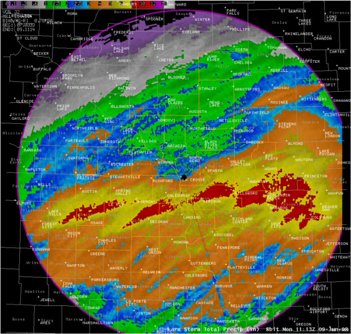
 PUBLIC INFORMATION STATEMENT
NATIONAL WEATHER SERVICE LA CROSSE WI
1204 PM CDT MON JUN 09 2008

...JUNE 7-8 2008 STORM TOTAL RAINFALL...

LOCATION                  RAINFALL    TIME          LAT/LON

IOWA

...ALLAMAKEE COUNTY...
DORCHESTER                7.30        0800 PM
LANSING 4SE               5.35        0700 AM  43.32N 91.16W
WAUKON                    4.99        0700 AM  43.27N 91.48W

...CHICKASAW COUNTY...
ION                       6.14        0800 PM

...CLAYTON COUNTY...
EDGEWOOD                  7.28        0700 AM  42.65N 91.40W
STRAWBERRY POINT          4.37        0700 AM  42.68N 91.53W
MARQUETTE                 4.27        0800 PM
ELKADER 6SSW              4.00        0700 AM  42.78N 91.45W
LITTLEPORT                3.74        0800 PM
ELKADER                   3.31        0700 AM  42.84N 91.40W

...FAYETTE COUNTY...
WAUCOMA 3SE               5.24        0700 AM  43.02N 91.98W
FAYETTE                   3.45        0700 AM  42.83N 91.80W
CLERMONT                  3.14        0800 PM
OELWEIN 1E                3.13        0700 AM  42.68N 91.88W

...FLOYD COUNTY...
COLWELL                   5.10        0700 AM  43.16N 92.59W
CHARLES CITY              4.78        0700 AM  43.05N 92.67W
ROCKFORD                  4.73        0830 PM

...HOWARD COUNTY...
ELMA                      6.25        0700 AM  43.24N 92.43W
CRESCO                    4.30        0800 PM

...MITCHELL COUNTY...
ST ANSGAR                 5.64        0800 PM
OSAGE                     5.13        0700 AM  43.28N 92.80W

...WINNESHIEK COUNTY...
BLUFFTON                  7.23        0800 PM
KENDALLVILLE              7.00        0720 PM
DECORAH                   6.60        0800 PM
FORT ATKINSON             5.30        0739 PM


MINNESOTA

...FILLMORE COUNTY...
HARMONY                   7.35        0700 AM  43.56N 92.01W
SPRING VALLEY 8SSE        4.70        0800 PM
SPRING VALLEY             4.36        0700 AM  43.69N 92.39W
SPRING VALLEY 3SW         4.14        0700 AM  43.66N 92.41W

...HOUSTON COUNTY...
RENO 3SW                  10.10       0800 PM
BROWNSVILLE               6.10        0800 PM
LA CRESCENT 1N            5.41        0748 PM
HOUSTON                   4.72        0800 PM
SPRING GROVE 4N           4.05        0800 PM

...MOWER COUNTY...
GRAND MEADOW              3.65        0800 PM
AUSTIN                    2.85        0800 PM
AUSTIN - KAAL             2.08        0800 PM

...OLMSTED COUNTY...
ROCHESTER                 1.83        0800 PM

...WABASHA COUNTY...
THEILMAN                  1.71        0700 AM  44.29N 92.19W

...WINONA COUNTY...
WINONA DAM 5A             2.49        0700 AM  44.09N 91.67W


WISCONSIN

...ADAMS COUNTY...
ARKDALE                   5.25        0800 PM

...BUFFALO COUNTY...
MONDOVI 6S                1.23        0700 AM  44.48N 91.67W

...CRAWFORD COUNTY...
STEUBEN                   5.37        0800 PM
GAYS MILLS                3.40        0800 PM
PRAIRIE DU CHIEN          3.08        0800 PM

...GRANT COUNTY...
ROCKVILLE                 5.15        0800 PM
BURTON                    4.58        0800 PM
FENNIMORE                 3.03        0700 AM  42.98N 90.65W
CUBA CITY                 2.93        0700 AM  42.60N 90.43W

...JACKSON COUNTY...
TAYLOR                    2.06        0700 AM  44.32N 91.12W

...JUNEAU COUNTY...
HUSTLER                   6.25        0800 PM
NECEDAH 2SE               5.98        0700 AM  44.00N 90.04W
NECEDAH 3E                5.75        0800 PM
NECEDAH 2NE               4.71        0800 PM
VOLK FIELD                4.62        0800 PM

...LA CROSSE COUNTY...
LA CROSSE 5 SE            7.44        0700 AM  43.77N 91.15W
WEST SALEM 1W             4.57        0700 AM  43.90N 91.10W
LA CROSSE                 4.42        0700 AM  43.87N 91.27W
ONALASKA 2N               3.70        0700 AM  43.92N 91.22W
HOLMEN 2S                 3.60        0700 AM  43.93N 91.25W
FOUR CORNERS              1.95        0700 AM  44.07N 90.92W

...MONROE COUNTY...
NORWALK                   7.20        0604 PM
WILTON                    5.25        0800 PM
TUNNEL CITY 1S            4.47        0700 AM  44.01N 90.57W
SPARTA                    3.91        0800 PM
WARRENS 5WSW              2.44        0700 AM  44.10N 90.59W

...TAYLOR COUNTY...
GAD                       1.93        0700 AM  45.14N 90.20W

...VERNON COUNTY...
WESTBY 3ENE               9.24        0700 AM
ONTARIO                   9.84        0800 PM
VALLEY 1NW                9.00        0546 PM
VIROQUA                   8.46        0700 AM  43.54N 90.87W
HILLSBORO                 7.55        0800 PM
LA FARGE                  7.53        0700 AM  43.57N 90.64W
STODDARD 3NE              6.83        0700 AM
DESOTO                    6.58        0700 AM  43.43N 91.20W
LA FARGE                  6.39        0800 PM
GENOA                     4.50        0800 PM
READSTOWN                 3.41        0800 PM

OBSERVATIONS ARE COLLECTED FROM A VARIETY OF SOURCES WITH VARYING
EQUIPMENT AND EXPOSURE. NOT ALL DATA LISTED IS CONSIDERED OFFICIAL.

FOR THIS...AND A WEALTH OF OTHER RIVER AND WEATHER INFORMATION...
VISIT OUR WEBSITE AT  WEATHER.GOV/LACROSSE
 |
Media use of NWS Web News Stories is encouraged! Please acknowledge the NWS as the source of any news information accessed from this site. |
|


 Weather Story
 Weather Map
 Local Radar