
Dangerous heat will expand from the Gulf Coast into the Southern Plains and Desert Southwest through week's end. Additional extreme heat impacting the Pacific Northwest will shift to the northern Plains by the weekend. Tropical Storm Bertha is expected to continue to impact portions of the northwestern Gulf Coast from south central Louisiana to the upper Texas coast today. Read More >
Overview
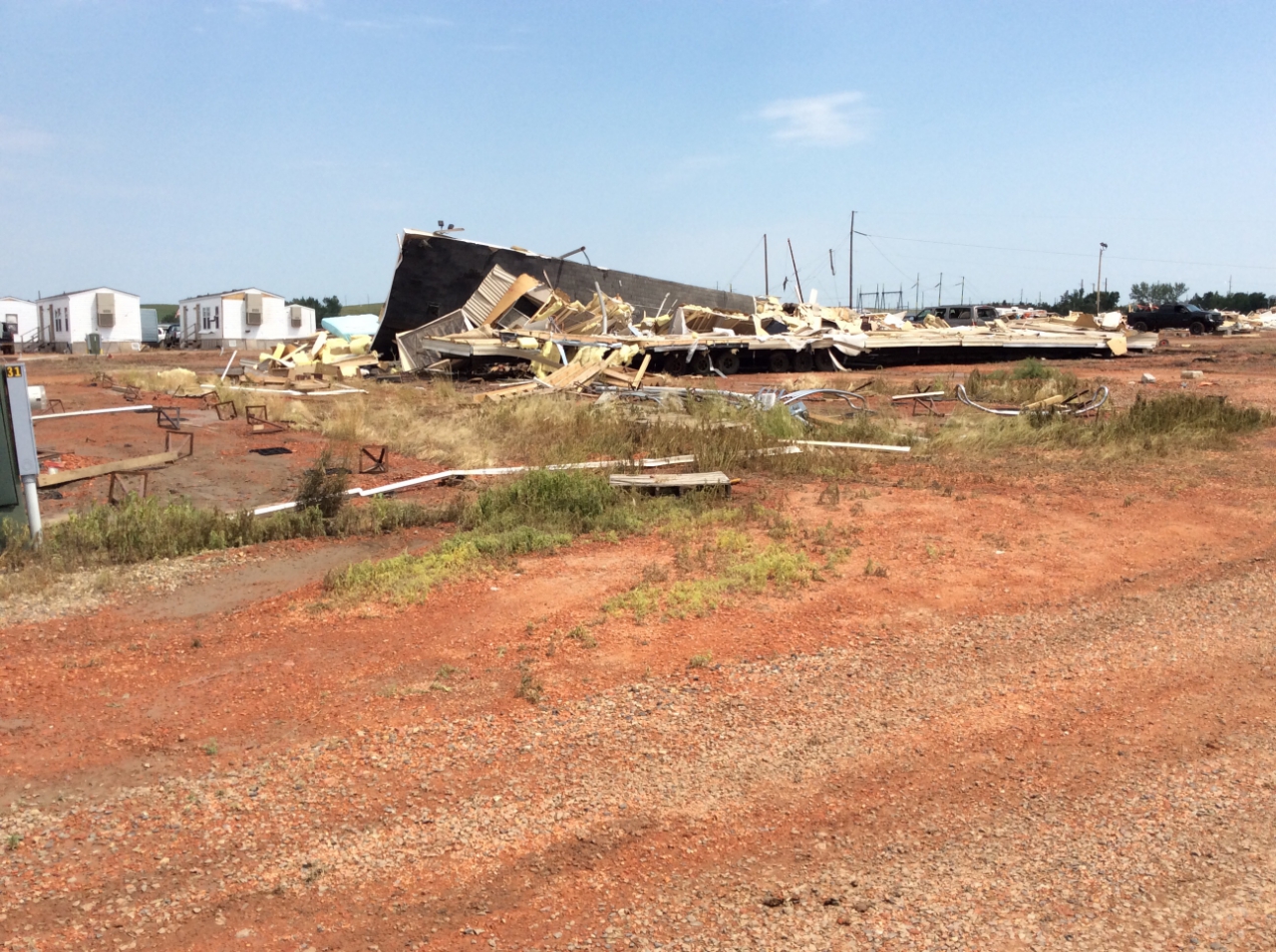
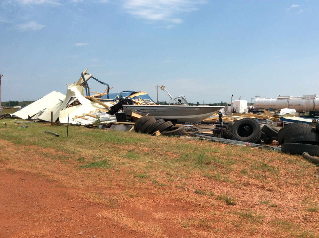
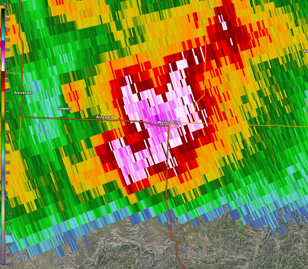
Significant severe thunderstorms impacted northwest and parts of central North Dakota late Monday evening, July 9th, into the early morning hours of Tuesday, July 10th, 2018. The National Weather Service storm damage assessment team confirmed that an EF2 tornado impacted the Watford City area around 12:45 AM CDT July 10th.
Tornado:
|
Tornado - Watford City Area
Track Map .png) 
|
||||||||||||||||||
The Enhanced Fujita (EF) Scale classifies tornadoes into the following categories:
| EF0 Weak 65-85 mph |
EF1 Moderate 86-110 mph |
EF2 Significant 111-135 mph |
EF3 Severe 136-165 mph |
EF4 Extreme 166-200 mph |
EF5 Catastrophic 200+ mph |
 |
|||||
Hail/Wind:
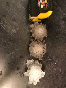
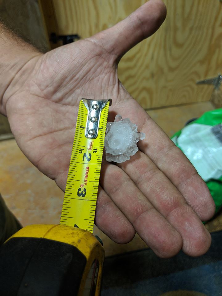
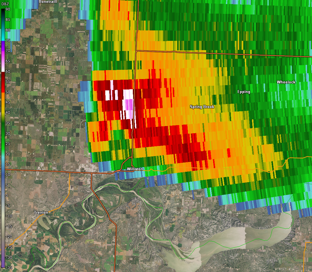
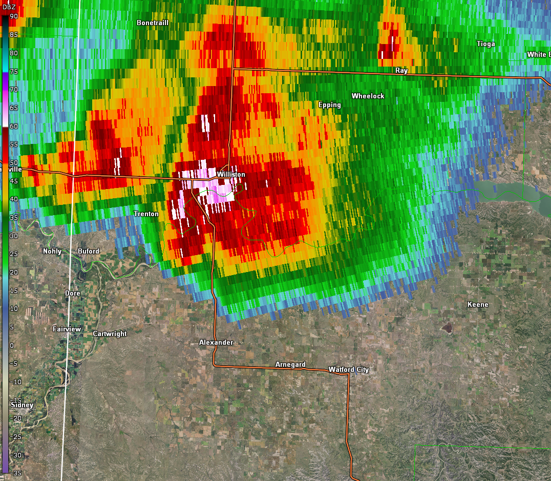
On the evening of July 9th, 2018, powerful supercell thunderstorms moved into northwestern North Dakota from northeast Montana and southeast Saskatchewan, Canada. The leading supercell just missed Williston to the north, but trained spotters reported golf ball size hail 6 miles southwest of Grenora and the storm also produced quarter size hail 5 miles northeast of Williston, before weakening. The second storm that would go on to produce the EF2 tornado at Watford City during the early morning hours of July 10th, put down golf ball to tennis ball size hail west of Williston and tennis ball size hail about 12 miles southwest of Bonetrail. While the brunt of this storm skirted Williston to the west, quarter to golf ball size hail was reported within the city limits. Additionally, a 62 mph thunderstorm wind gust was measured at Sloulin Field International Airport in Williston with this second storm.
In addition to the tornado, the second storm produced a swath of 75 mph straight line winds across parts of McKenzie County.
.jpeg) |
 |
.jpg) |
 |
|
Golf Ball to Tennis Ball Size Hail West of Williston (Photo Credit Unknown) |
Golf Ball Size Hail 10 Miles Northwest of Williston (Photo taken by a Firefighter, Relayed to the NWS via Emergency Manager) | Half Dollar Size Hail in Williston (Photo Taken by Amy Johnson) | Hail From 7 Miles West of Williston (Photo Taken by Emily Wion) |
Photos & Video:
 |
 |
 |
 |
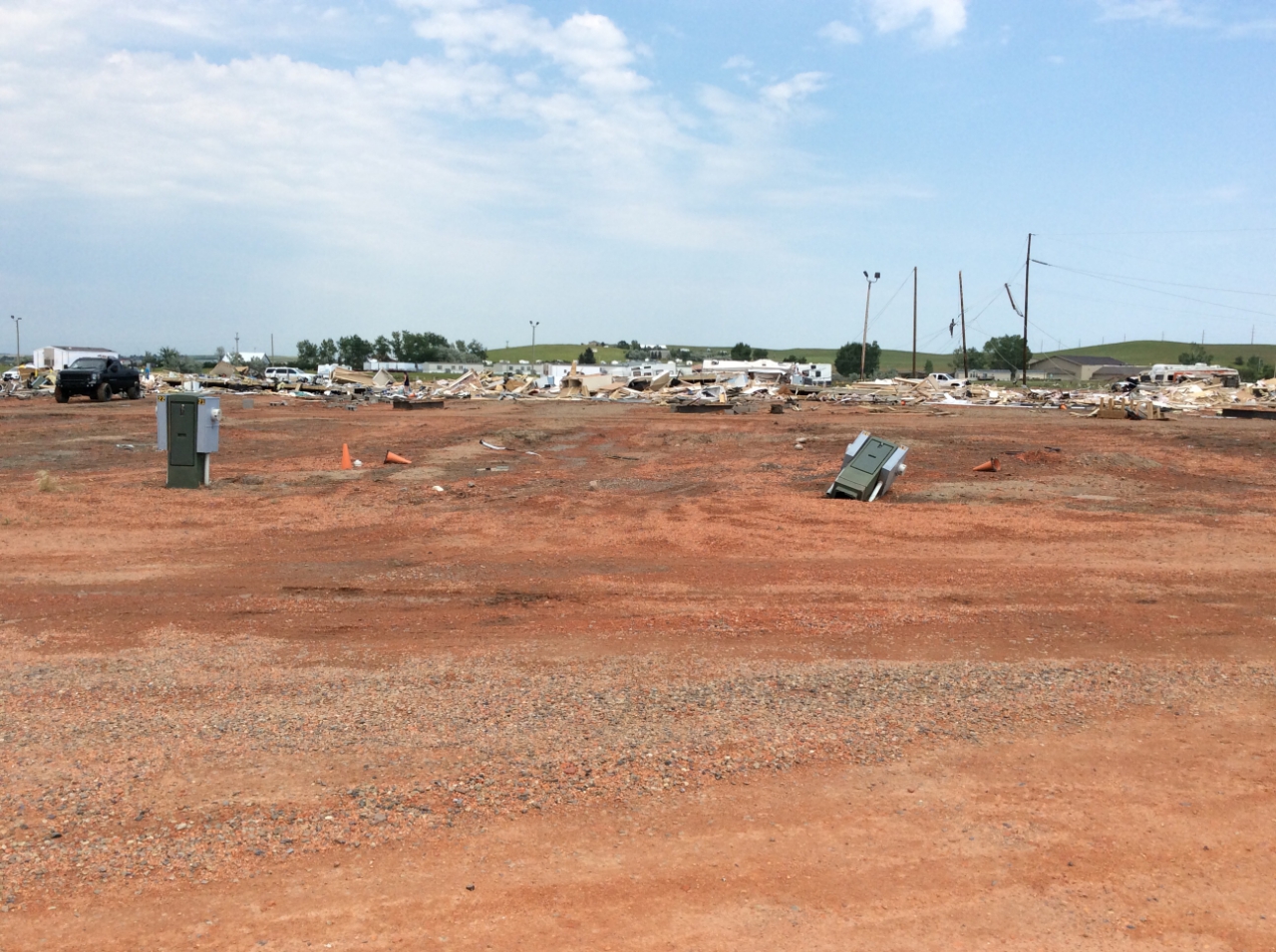
| Destroyed Manufactured Home - Single Wide, Watford City (NWS Damage Survey Photo) | Destroyed Small Storage Building, Watford City (NWS Damage Survey Photo) |
Wider View of Destroyed Manufactured Homes and RVs, Watford City (NWS Damage Survey Photo) |
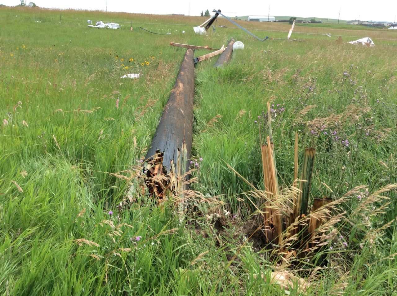
Wooden Power Pole, Watford City (NWS Damage Survey Photo) |
.jpg) |
.jpg) |
 |
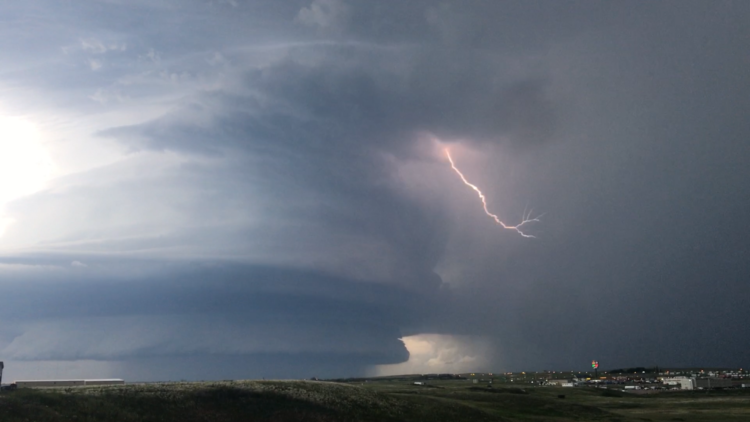 |
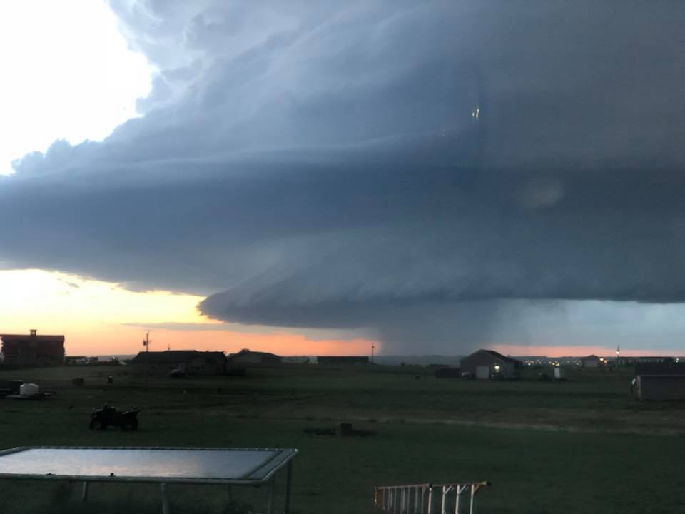
| Initial Supercell Looking Northwest from Williston on the Evening of 7/9/2018. (Photo Taken by Jordan Muir) | Initial Supercell Looking Northwest from Williston on the Evening of 7/9/2018. (Photo Taken by Cindy Lindvig-Getzlaff) | Initial Supercell Looking Northwest from Williston on the Evening of 7/9/2018. (Photo Taken by Amy Patterson-Sanders) | Initial Supercell Looking Northwest from Williston on the Evening of 7/9/2018. (Photo Taken by Tasha Herrin) |
Radar:
Radar Images from the Storms
 |
 |
 |
.gif) |
| Large-hail-producing supercell thunderstorm north of Williston around 1010 PM CDT | Storm impacting Williston with large hail and strong winds around 1130 PM CDT | Tornado-producing storm impacting the Watford City area around 1245 AM CDT | Event radar loop |
Storm Reports
..TIME...   ...EVENT...      ...CITY LOCATION...     ...LAT.LON...
..DATE...   ....MAG....      ..COUNTY LOCATION..ST.. ...SOURCE....
            ..REMARKS..

0915 PM     HAIL             6 SW GRENORA            48.56N 104.03W
07/09/2018  E1.75 INCH       WILLIAMS           ND   TRAINED SPOTTER

            HAIL SIZES RANGED FROM DIME TO GOLF BALL.

0915 PM     HAIL             9 SSW GRENORA           48.51N 104.04W
07/09/2018  E1.00 INCH       WILLIAMS           ND   TRAINED SPOTTER

            CORRECTS PREVIOUS HAIL REPORT FROM 9 SSW
            GRENORA. NICKEL TO QUARTER SIZE HAIL LASTED
            FOR ABOUT A MINUTE.

1015 PM     FUNNEL CLOUD     5 NW WILLISTON          48.21N 103.70W
07/09/2018                   WILLIAMS           ND   FIRE DEPT/RESCUE

            LOCATION APPROXIMATE. FIREFIGHTER WITNESSED
            A FUNNEL CLOUD NORTHWEST OF WILLISTON.
            RELAYED BY EMERGENCY MANAGER.

1025 PM     HAIL             5 NNE WILLISTON         48.21N 103.58W
07/09/2018  E1.00 INCH       WILLIAMS           ND   TRAINED SPOTTER

            LASTED JUST A FEW MINUTES. HAIL WAS HEAVIER
            JUST NORTH OF SPOTTER.

1038 PM     HAIL             SPRING BROOK            48.26N 103.46W
07/09/2018  E1.00 INCH       WILLIAMS           ND   BROADCAST MEDIA


1040 PM     HAIL             9 WSW BONETRAIL         48.35N 104.00W
07/09/2018  E1.75 INCH       WILLIAMS           ND   TRAINED SPOTTER

            HAIL LASTED FOR 20 MINUTES (1030-1050 PM).
            BROKEN WINDOW ON THE NORTH SIDE OF HOUSE.

1050 PM     HAIL             12 SSW BONETRAIL        48.26N 103.94W
07/09/2018  E2.50 INCH       WILLIAMS           ND   PUBLIC

            RELAYED THROUGH BROADCAST MEDIA.

1126 PM     HAIL             WILLISTON               48.16N 103.62W
07/09/2018  E1.75 INCH       WILLIAMS           ND   PUBLIC

            RELAYED THROUGH BROADCAST MEDIA.

1130 PM     HAIL             6 NNE TRENTON           48.16N 103.78W
07/09/2018  M1.75 INCH       WILLIAMS           ND   PUBLIC


1131 PM     TSTM WND GST     SLOULIN FIELD-INTL APT  48.18N 103.64W
07/09/2018  M62 MPH          WILLIAMS           ND   ASOS

            ASOS STATION ISN, SLOULIN FIELD-INTL APT.

1148 PM     HAIL             1 E WILLISTON           48.16N 103.60W
07/09/2018  E1.25 INCH       WILLIAMS           ND   EMERGENCY MNGR


1230 AM     HAIL             ALEXANDER               47.85N 103.64W
07/10/2018  E1.00 INCH       MCKENZIE           ND   PUBLIC

            RELAYED THROUGH BROADCAST MEDIA.

1234 AM     TSTM WND GST     ARNEGARD                47.81N 103.44W
07/10/2018  E60 MPH          MCKENZIE           ND   LAW ENFORCEMENT


1245 AM     TORNADO          1 SSW WATFORD CITY      47.78N 103.29W
07/10/2018                   MCKENZIE           ND   NWS STORM SURVEY

            *** 1 FATAL, 28 INJ ***
            TIME ESTIMATED BASED ON RADAR AND EYE
            WITNESS REPORTS. EXTENSIVE AND SEVERE DAMAGE
            AT AN RV / TRAILER PARK ON THE SOUTHWEST
            SIDE OF WATFORD CITY. NWS DAMAGE SURVEY
            CONFIRMS EF2 TORNADO AND BASED ON THAT
            ESTIMATES WIND SPEEDS AROUND 127 MPH. MANY
            SINGLE WIDE MANUFACTURED HOMES AND RVS
            DESTROYED. POWER POLES SNAPPED. STORAGE
            BUILDINGS AND VEHICLES DESTROYED.
            WEATHER.GOV/BIS HAS MORE DETAILS. INJURIES
            AND FATALITY BASED ON NEWS REPORTS.

1255 AM     TSTM WND GST     1 E WATFORD CITY        47.80N 103.26W
07/10/2018  M59 MPH          MCKENZIE           ND   AWOS

            AWOS STATION S25, 1 E WATFORD CITY.

1255 AM     TSTM WND DMG     1 S WATFORD CITY        47.79N 103.28W
07/10/2018                   MCKENZIE           ND   911 CALL CENTER

            STATE RADIO RELAYED POSSIBLY 30-40 CAMPERS
            FLIPPED OVER. TIME ESTIMATED FROM WIND GUST
            REPORT AT WATFORD CITY AWOS.

0104 AM     TSTM WND DMG     WATFORD CITY            47.81N 103.28W
07/10/2018                   MCKENZIE           ND   PUBLIC

            POWER LINES DOWN. RELAYED BY BROADCAST
            MEDIA.
 |
Media use of NWS Web News Stories is encouraged! Please acknowledge the NWS as the source of any news information accessed from this site. |
|

