
A Winter Storm Watch is in effect for southeastern St. Lawrence County in New York. Lake effect snow is expected to develop, with total snow accumulations between 4 and 10 inches possible. Travel could be very hazardous, especially for anyone traveling for the Thanksgiving holiday. Continue to monitor the latest forecasts for updates. Read More >
 Email the author
January 5, 2023 – This week marks the 25th Anniversary of the 1998 Ice Storm that devastated parts of northern New England, northern New York and especially the St. Lawrence River valley of Canada from January 5th through January 9th, 1998.
This storm had historic impacts across northern New York, northern New England and southeast Canada due to the prolonged duration of the event, magnitude of the ice accretion and precipitation amounts. Although the actual weather event lasted from January 5th-9th, the impacts and recovery efforts of power restoration, clearing debris and “returning to normal†lasted weeks, even months for those hardest impacted.
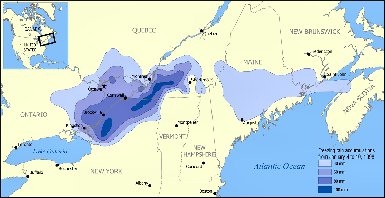
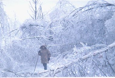
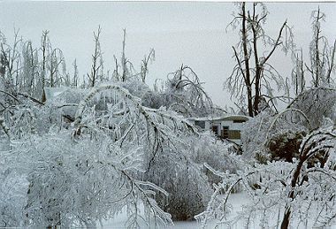
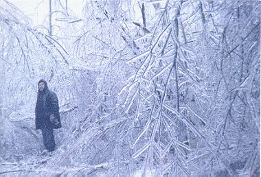
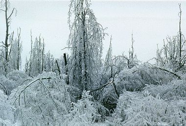
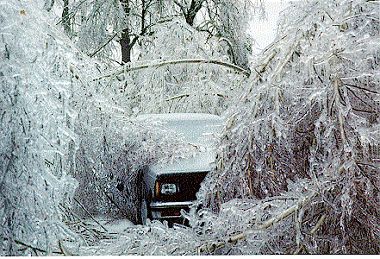
The most infamous aspect of this storm was the destructive ice accumulation of up to 4 inches (100 mm) in portions of northern New York and southeast Canada, with heavy ice accumulation of 3/4-2 inches across portions of northern New England (Figure 1). In addition, the amount of liquid equivalent precipitation that fell across the region during these five days, including more than 5 inches of rain in the Black River Valley in upstate New York, led to major flooding.
 Some of the devastating impacts included the power grid with hundreds of large transmission towers toppled, thousands of poles snapped and utility lines downed resulting in millions of without power, some for longer than 2 weeks. The agriculture industry suffered great losses immediate and long term. Local farmers suffered many losses from structural damage due to ice loading, tons of lost milk production and losses of cattle due to the inability to milk. Additionally, thousands of maple and apple trees were damaged or destroyed that had significant impacts for years due to lost crops. Moreover, millions of acres of forests were damaged or destroyed by this event.
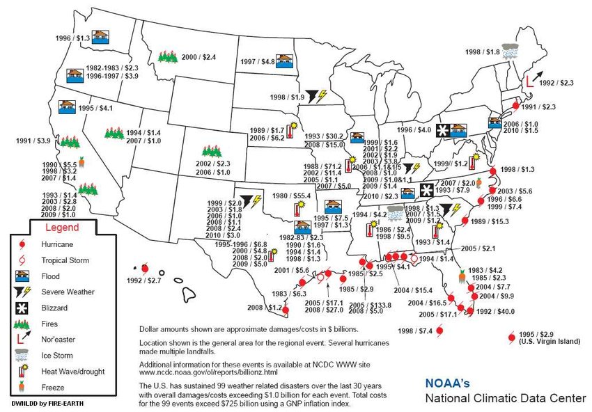
Storm damage estimates for this storm were more than $4 billion ($1.4B in the U.S.) with approximately 40 fatalities. This was and is still today the only billion dollar natural disaster to impact northern New York, Vermont, New Hampshire and Maine since 1980.
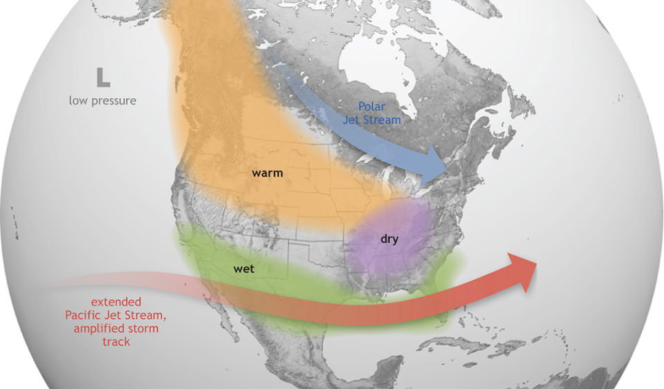 This historic winter storm had its origins from a strong El-Nino pattern that was influencing weather patterns during the winter of 1997-98. Moderate to strong El-Nino patterns are famous for their impacts across the West coast of the United States, especially California.
However, moderate to strong El-Nino's tend to influence the jet stream in two significant ways that can have affects well downstream including the Ice Storm of 1998. First, the subtropical Pacific jet is more active and brings more moisture to the Pacific coast and the southern tier of the United States. Second, the polar and arctic jet streams tend to stay across Canada with temperatures near or above normal across the continental United States.
Meteorological Background
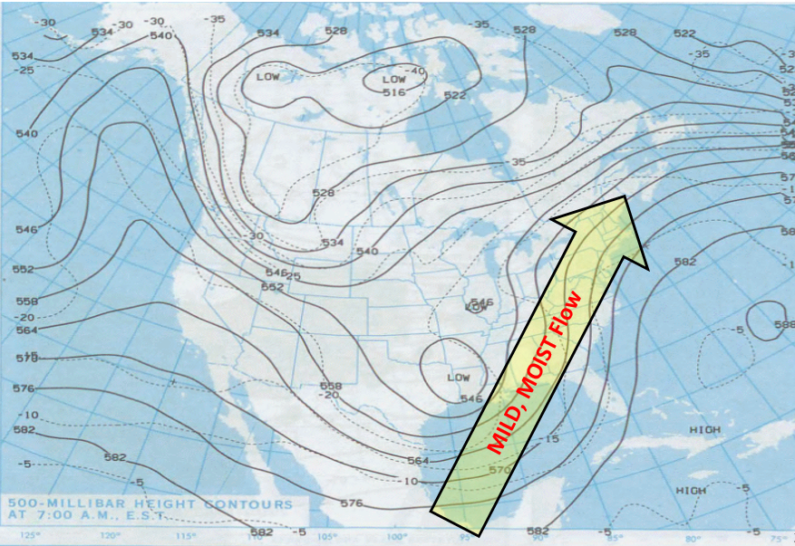
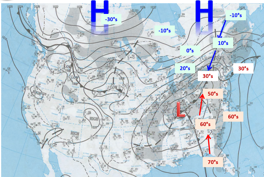
 On January 5th, a long wave trough was across the Rockies while a ridge was building across the East coast of the United States and the Atlantic Ocean. This combination develops a persistent mild southwest to northeast flow from the Pacific Ocean and Mexico to the northeast United States and southeast Canada.
At the surface, an elongated area of cold, arctic high pressure lies from north-central Canada east across Quebec into Nova Scotia with a stationary front draped across the Canadian-United States border with temperatures in the teens and 20's across southern Quebec and southern Ontario, around freezing along the immediate Canadian & New York border, and above freezing elsewhere in New England and New York.
This frontal boundary would be key for temperatures and precipitation during this event. Meanwhile, another boundary that moved through the North Country on the 4th was positioned from the New Jersey shore west to a weak area of low pressure across the Great Lakes with another stationary boundary draped between this system and another surface low across Texas.
 During the night of the 5th, the surface low across the Great Lakes slowly traversed along the stationary boundary that was draped toward the East coast. An overrunning pattern of mild, moist air traveling above cooler, dense air at the surface accounted for a light shield of precipitation that overspread southeast Canada, northern New York and northern Vermont.
Temperatures remained below freezing across southeast Canada and along the immediate Canadian border in New York, thus freezing rain was widespread resulting in the start of ice accumulation.
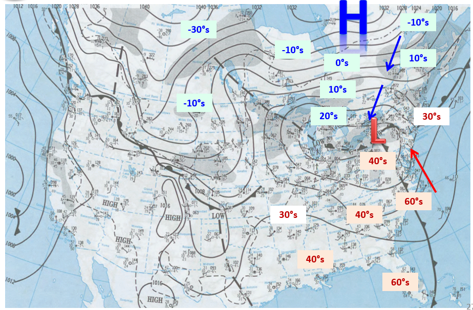
 On the 6th, the strong arctic high pressure system that was located across north central Canada started to migrate toward Quebec, thus creating a stronger pressure gradient between the Great Lakes/Northeast surface low. This stronger gradient and clockwise flow around high pressure accounted for a strengthening flow of cold, dense air from northeast Quebec southwest down the St. Lawrence River Valley of Quebec into the St. Lawrence River and northern Champlain Valleys in New York and Vermont.
Meanwhile, the surface wave along the stationary boundary continued to move south of the region accounting for continued light precipitation. However, with the greater areal expansion of sub-freezing temperatures (mid 20s to lower 30s) came a larger area affected by freezing rain.
Main Event ~ January 7-9th
January 7th would be the table setter for the "main event" that would occur across southeast Canada, northern New York and northern New England later that night and continue through January 9th. During the 7th, arctic high pressure across northeast Quebec would continue to build toward Nova Scotia and eastern Maine, thus maintaining a persistent flow of low-level subfreezing air into the St. Lawrence and Champlain Valleys with temperatures falling into the lower to mid-20s.
Meanwhile, a persistent mild and moist flow above the surface (originating from the Gulf of America) would continue to override the cold low-levels for periods of freezing rain across the Champlain and St. Lawrence Valleys.
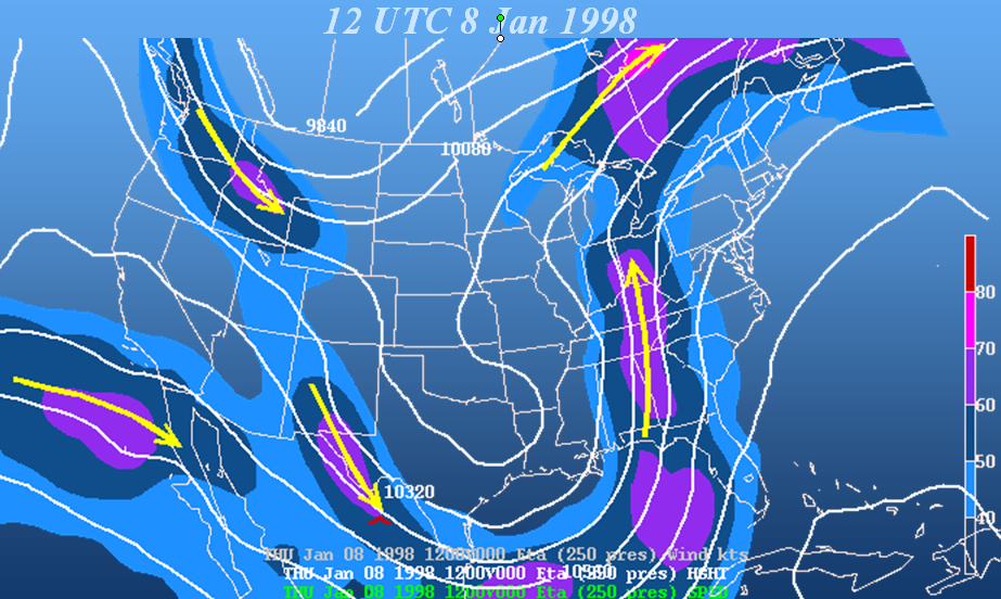
Elsewhere, the deep long wave trough, originally across the Rockies on the 5th, had shifted into Texas and the Gulf of America, with an attendant surface low near the northern Gulf coast. This highly amplified flow interacted with the subtropical jet stream, thus acquiring rich moisture. Both the developing surface low and the deep abundant moisture would travel along the stationary boundary across the Mississippi and Ohio River Valleys, then east into the northeast during the night of the 7th through the 9th.
The Gulf of America surface low tracked along the stationary boundary across the Mississippi and Ohio River Valleys on the 8th and across New England on the 9th.
 Meanwhile, the subtropical jet stream advected a deep moisture plume along and ahead of the surface system.
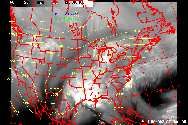
This water vapor image loop from 7 pm EST on January 6th through 7am EST on January 9th clearly shows the deep layered moisture being transported from the Gulf of America toward the Northeast. In addition, the swirling "darker" imagery from New Mexico/Texas and lifting into the Mid-Atlantic is the upper atmospheric storm that delivers the heaviest precipitation to the northeast during the night of January 7th through midday on January 9th.
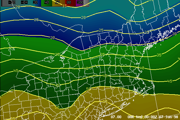
 Steady and heavy precipitation overspread northern New York, northern New England and southeast Canada on the night of the 7th and continued through the 9th with precipitation amounts of several inches observed during this period. Some of these tremendous precipitation amounts set daily records for January 8th (Burlington ~ 2.11" and Massena ~ 1.87").
However, the most devastating and overwhelming aspect of this tremendous precipitation event was the type of precipitation - freezing rain - as surface temperatures remained primarily below freezing, in the 20s for the most part with some minor fluctuations.
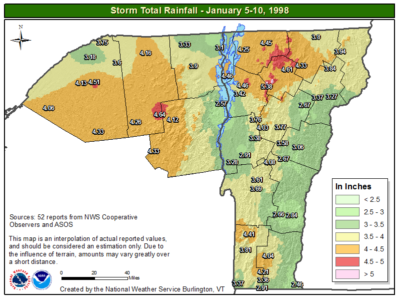 Storm total precipitation for the event from NWS Burlington spotters, Cooperative Weather Observers and NWS/FAA sites ranged from around 1.5" in southern Vermont to amounts exceeding 6" in extreme northern Vermont.
The heaviest precipitation occurred across northern New York and the border counties in Vermont. There was some missing data in northern New York, thus most of the region exceeded 4 inches of precipitation.
 Freezing rain is a meteorological phenomenon that is strongly elevation dependent, but is opposite of standard atmospheric conditions. In a standard atmosphere, the surface of the earth is warmer than the atmosphere above it, thus the temperature cools with height.
Therefore in marginally cold conditions, precipitation originates as snow in the cloud and will fall as snow through much of its travels to the surface, then turn to a cold rain or wet snow in the valleys as the surface temperature is above freezing, with accumulating snow in the higher elevations where the temperature is below freezing. The opposite is true with a freezing rain event.
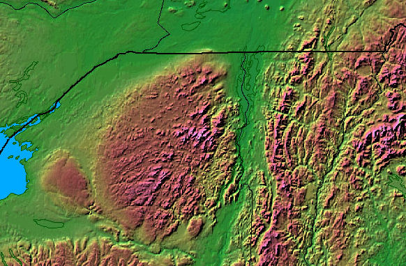
Precipitation will form as snow or rain in the cloud and then fall toward the surface through a relatively mild layer that melts the precipitation into rain until it encounters a shallow cold sub-freezing layer near the surface, where the precipitation still remains as rain, but freezes on contact with various sub-freezing objects. Cold air is denser than mild air, thus in complex terrain, the valley floor is colder than the neighboring higher terrain.
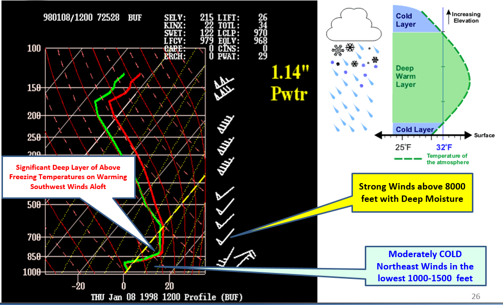
The atmospheric sounding from Buffalo, NY on the morning of January 8th, shows strong southwest winds (50 knots) above 8000 feet bringing in milder air with temperatures above freezing (0 degrees Celsius) from approximately 2000 to 12,000 feet, thus all precipitation is falling in the form of rain. Meanwhile below 1500 feet, winds have shifted to the northeast delivering sub-freezing temperatures at and near the surface. The depth of the sub-freezing air is not deep enough to change rain to sleet/ice pellets, therefore it falls as super cooled rain droplets that instantaneously freeze to surface objects and accumulate over time to produce dangerous icing.
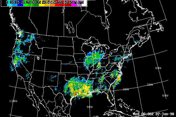
 A 3-hourly increment time lapse loop from 7 pm EST on January 6th through 7am EST on January 9th shows the cold air drainage across the St. Lawrence and Champlain Valleys where temperatures remained primarily below freezing.
Meanwhile, temperatures were just above freezing for most of the event elsewhere across Vermont and northern New York. Also, temperatures were in the 40s and 50s along the New York-Pennsylvania border with several failed attempts for the frontal boundary to move northward toward the North Country.
 The freezing rain with this event was concentrated in the St. Lawrence and Champlain Valleys of Canada, New York and Vermont due to the continued advection of cold, dense air from eastern Quebec down to St. Lawrence River valley into these locations.
Ice had already accumulated to a half inch in the Champlain Valley and up to an inch in the St. Lawrence Valley for several days preceding this heavy precipitation. Therefore, the heavy accumulation and build-up of ice from the 7th through the 9th had devastating and life-threatening consequences across the region.
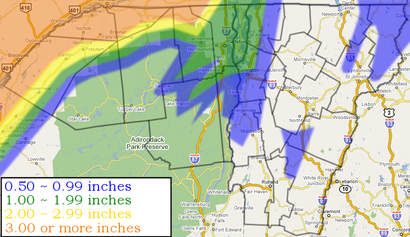 Storm total ice accumulation was greatest in the St. Lawrence Valley of northern New York and Canada with 2 to 4 inches (50 to 100 mm), 1 to 2 inches (25 to 50 mm) of ice accumulated in the northern Champlain Valley (from Burlington, VT to Port Kent, NY northward) with a half to one inch (12.5 to 25 mm) across the central Champlain Valley (Middlebury to Burlington), the eastern foothills of the Adirondacks and western slopes of the Green Mountains, as well as pockets of higher elevations in central and northeast Vermont.
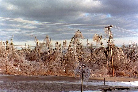
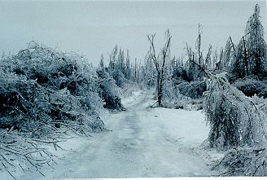
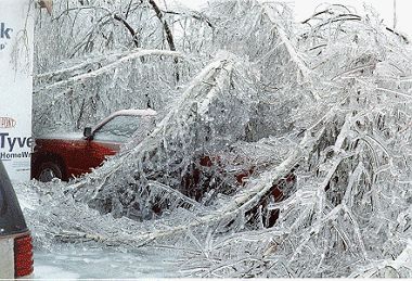
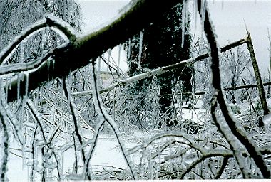
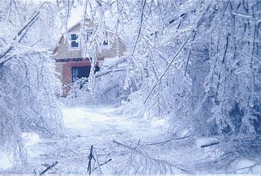
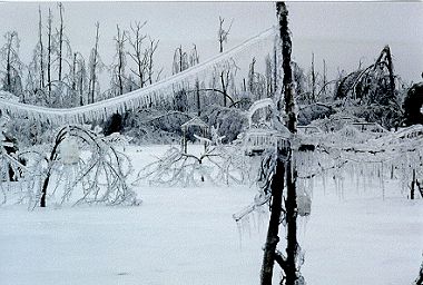
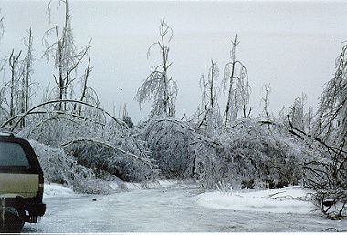
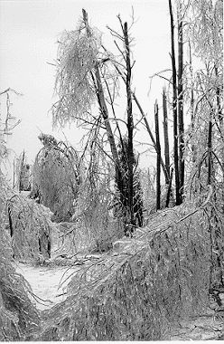
Rapid and tremendous ice accumulation during the night of the 7th and continuing through the 9th downed millions of trees and branches which fell on vehicles, homes and power lines. Thousands of power lines, power poles and electrical towers fell due to the weight of the ice accumulation itself, which accounted for millions of people without power across southeast Canada, northern New York and the Champlain Valley of Vermont. Roads were impassable due to fallen trees, power lines and the extremely treacherous ice accumulation on roadways led to numerous vehicle accidents.
The sheer magnitude of the January 1998 Ice Storm, including its areal coverage, total ice accretion, and duration led to additional "secondary" consequences. The devastation of millions of trees, including maple and apple trees affected the maple sugaring and apple industry for years across the Champlain and St. Lawrence Valleys. Extensive power outages that lasted days and weeks, resulted in businesses closed for extended periods, farmers losing milk and cattle due to the inability to milk cattle, electric utilities seeking assistance from other parts of the country to repair lost infrastructure and the loss of heat in thousands of households. The loss of electricity and reliable heat sources lead to "unsafe" practices to restore these basic necessities. Improper use of portable generators or alternate heat sources such as gas stoves and gas grills lead to scores of carbon monoxide poisoning injuries and unfortunately several deaths.
Summary
The Devastating Ice Storm of January 1998 was a historic storm that affected millions of people across northern New York, northern New England and southeast Canada.
Some of the origins of this storm were tied to a phenomenon in the Pacific Ocean called El-Nino. Deep tropical moisture was supplied by a jet stream pipeline from the Gulf of America which delivered record rainfall across the affected area, while at the same time, low-level cold dense air was supplied by high pressure across Quebec.
Property damage was in the billions of dollars, millions of acres of trees were damaged or destroyed and millions of people lost power for days and even weeks. However, a very large majority of injuries and fatalities with this storm were caused by human, "indirect" sources that are largely preventable. These sources include vehicle accidents, carbon monoxide poisoning, electrocution from touching downed electrical wires during storm clean-up and other injuries resulting from post storm clean-up.
Winter storms occur every year across much of the United States, resulting in "non-preventable" storm damage such as damaged trees, downed power lines, loss of power and treacherous travel (ground and air). However, winter storms often bring about injuries and fatalities that can be "prevented", such as motor vehicle accidents and carbon monoxide poisoning.
NOAA's National Weather Service and other safety agencies strongly urge you to monitor forecasts, prepare for the elements and take precautions when weather hazards arise. Curtail any unnecessary travel during inclement winter weather as motor vehicle accidents are the primary source of storm related injuries and fatalities.
Carbon monoxide poisoning generally occurs as a result of improper usage and ventilation of alternate power and heat sources during a power outage due to a storm. Gas grills, propane heaters and portable generators should NEVER be used inside a home and gas stoves should only be used for cooking, not as an alternate heat source. Carbon monoxide is odorless and tasteless, thus offering no warning of the deadly gas. Battery powered carbon monoxide detectors (unless connected to an outlet provided by a back-up generator) are the easiest and safest way to protect yourself and others from carbon monoxide poisoning.
Carbon monoxide can build up in homes due to blocked heating system exhaust vent usually the result of heavy snowfalls, especially where wind can blow and drift the snow, such as the Valentine’s Day Storm of 2007 and the March 2017 Blizzard. Therefore, it's a good practice to regularly check your exhaust vents during and/or after a heavy snowfall and remove any obstruction by several feet.
Again, It's NEVER too late to plan, review and prepare for winter weather and the hazards before and during the winter season.
Resources
Photo Gallery (Images from Mooers, NY from former NWS Employee John Ferguson)

