HOME
FORECAST
Local
Graphical
Aviation
Marine
Rivers and Lakes
Hurricanes
Severe Weather
Fire Weather
Sunrise/Sunset
Long Range Forecasts
Climate Prediction
Space Weather
PAST WEATHER
Past Weather
Astronomical Data
Certified Weather Data
SAFETY
INFORMATION
Wireless Emergency Alerts
Weather-Ready Nation
Brochures
Cooperative Observers
Daily Briefing
Damage/Fatality/Injury Statistics
Forecast Models
GIS Data Portal
NOAA Weather Radio
Publications
SKYWARN Storm Spotters
StormReady
TsunamiReady
Service Change Notices
EDUCATION
NEWS
SEARCH
Search For
NWS
All NOAA
ABOUT
About NWS
Organization
For NWS Employees
National Centers
Careers
Contact Us
Glossary
Social Media
NWS Transformation
Local forecast by
"City, St" or ZIP code
Sorry, the location you searched for was not found. Please try another search.
Multiple locations were found. Please select one of the following:
Location Help
News Headlines
The Latest Drought Status for Vermont and northern New York!
Information on 2025 BTV Frost Freeze Program
Customize Your
Weather.gov
Enter Your City, ST or ZIP Code
Remember Me
LOADING...
Burlington, VT
Weather Forecast Office
Lake Champlain Point Forecasts
Weather.gov
>
Burlington, VT
> Lake Champlain Point Forecasts
Current Hazards
Briefing Page
River Flooding
Local Outlook
Space
Winter
Drought
Thunderstorms
Hurricanes
Graphical Hazards Outlook
Current Conditions
Observations (Map)
Satellite
Air Quality
Rainfall
Observations (List)
Mesoscale Analysis
Spotter Reports
Local Storm Reports
Webcams
Road Conditions
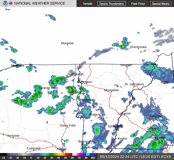
Radar
Local KCXX Enhanced Radar
Local KCXX Standard Radar (low bandwidth)
Regional Standard Radar (low bandwidth)
National Standard Radar (low bandwidth)
Local KTYX Standard Radar (low bandwidth)
Local KTYX Enhanced Radar
Forecasts
Forecasters' Discussion
Aviation
Tropical
Map View
Hourly View
Recreational
Fire Weather
Request Spot Forecast
Avalanche Weather Information
Air Quality
Rivers and Lakes
Current & Past Streamflow
Ensemble River Guidance
River Forecast Centers
River Observations (Map)
River Forecasts (Map)
Spring Flood Outlook
Local Drought Information Statement
Climate and Past Weather
Past Rainfall
CoCoRaHS
24 Hour Summary
Snowfall Records
Past Observed Weather
Drought Outlook
Climate Prediction
Local Climate Data/Records/Maps
Past Weather Event Summaries
Daily Climate Maps
Local Snowfall Analysis Archive
Tropical Cyclone Reports
Local Programs
COOP Program
Local Recorded Web Seminars
SKYWARN
Seasonal Newsletters
Host a NWS Talk
EM Wx Request
Local Research
Local CoCoRaHS Program
Safety Campaigns
Contact Us
Warning Criteria
Current Conditions
as of 8:00 AM EDT Fri Oct 10 2025
Location
Air Temp
(°F)
Wind
(kts)
Water Temp
(°F)
Wave Height
(ft)
Colchester Reef
41
S15G20
N/A
N/A
Diamond Island
36
S06G08
N/A
N/A
Burton Island
40
13G15
N/A
N/A
Note: Marine observations listed above are largely maintained outside of the control of NOAA/NWS, and thus, may be old or missing at times. Data is maintained by the
SUNY Plattsburgh Lake Champlain Research Institute
.
Additional Forecasts & Information
Forecast Discussion
Hazardous Weather
Local Climate
Recreational Forecasts
Regional Weather Conditions
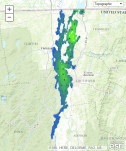
Interactive Forecast Map
Select Basemap
Topographic
Streets
Satellite
Ocean
Click Map to Select Another Point Forecast
About This Forecast
Point
Forecast:
Last Update:
Forecast Valid:
6AM EDT Fri Oct 10, 2025 to
6PM EDT Tue Oct 14, 2025
Radar & Satellite Images
Graphical Forecast
Radar
Current Weather
Rivers & Lakes
Satellite
Forecast Maps
Hour by Hour Forecast
Tropical Weather
Graphical Hazards
Recreational Forecast
Forecaster's Discussion
Text Bulletins
Submit Storm Report
Aviation
Fire Weather/Spot
Heat Safety
Weather Hazard Briefing
Climate Plots
Skywarn
Follow us on X
Follow us on Facebook
Follow us on YouTube
BTV RSS Feed