HOME
FORECAST
Local
Graphical
Aviation
Marine
Rivers and Lakes
Hurricanes
Severe Weather
Fire Weather
Sun/Moon
Long Range Forecasts
Climate Prediction
Space Weather
PAST WEATHER
Past Weather
Heating/Cooling Days
Monthly Temperatures
Records
Astronomical Data
SAFETY
Floods
Tsunamis
Beach Hazards
Wildfire
Cold
Tornadoes
Air Quality
Fog
Heat
Hurricanes
Lightning
Safe Boating
Rip Currents
Thunderstorms
Space Weather
Sun (Ultraviolet Radiation)
Safety Campaigns
Wind
Drought
Winter Weather
INFORMATION
Wireless Emergency Alerts
Brochures
Weather-Ready Nation
Cooperative Observers
Daily Briefing
Damage/Fatality/Injury Statistics
Forecast Models
GIS Data Portal
NOAA Weather Radio
Publications
SKYWARN Storm Spotters
StormReady
TsunamiReady
Service Change Notices
EDUCATION
Be A Force of Nature
NWS Education Home
NEWS
NWS News
Events
Pubs/Brochures/Booklets
NWS Media Contacts
SEARCH
Search For
NWS
All NOAA
ABOUT
About NWS
Organization
Strategic Plan
Commitment to Diversity
For NWS Employees
International
National Centers
Careers
Contact Us
Glossary
Social Media
Local forecast by
"City, St" or ZIP code
Sorry, the location you searched for was not found. Please try another search.
Multiple locations were found. Please select one of the following:
Location Help
News Headlines
Are you #WeatherReady for the Winter?
Check out the Fall 2023 issue of The Lake Breeze Newsletter
NWS Buffalo Winter Weather Page
Customize Your
Weather.gov
Enter Your City, ST or ZIP Code
Remember Me
LOADING...
Buffalo, NY
Weather Forecast Office
NWS Buffalo Weather Dashboard
Weather.gov
>
Buffalo, NY
> NWS Buffalo Weather Dashboard
Current Hazards
River Flooding
Briefing Page
Drought
Space
Local Outlook
Thunderstorms
Hurricanes
Winter
Enhanced Hazardous Weather Outlook (EHWO)
Current Conditions
Observations (List)
Rainfall
Air Quality
Satellite
Observations (Map)
Marine Obs (Map)
Lake Temperatures
Latest Reports (Public Information Statement)
Radar
Local KBUF Standard Radar (low bandwidth)
Local KBUF Enhanced Radar
Regional Standard Radar (low bandwidth)
National Standard Radar (low bandwidth)
Local KTYX Standard Radar (low bandwidth)
Local KTYX Enhanced Radar
Forecasts
Forecasters' Discussion
Hourly View
Map View
Aviation
Tropical
Activity Planner
Marine
UltraViolet
Fire Weather
Surf Zone/Beach
Winter
Rivers and Lakes
River Observations (Map)
River Forecasts (Map)
River Forecasts (Text)
Current & Past Streamflow
Ensemble River Guidance
River Forecast Centers
Climate and Past Weather
Past Observed Weather
24 Hour Summary
CoCoRaHS
Past Rainfall
Snowfall Records
Drought Outlook
Historical Records
Climate Prediction
Winter Season Summaries
Cooperative Observer Data
Lake Effect Page
Drought Information Statement
Local Programs
Office Staff
Tours
SKYWARN
StormReady
Upper Air
NOAA Weather Radio
Student Opportunities
Submit a Storm Report
Social Media Dashboard
Lake Breeze Newsletter
Emergency Management Support
River Ice Spotter Form
NWS Buffalo Weather Dashboard
Mobile Version
Current
Radar
Severe Outlook
Severe Probability
Hydro
Satellite
Marine
Winter
Climate
Forecast
Aviation
Tropical
ALL WATCHES/WARNINGS
|
BUF WATCHES/WARNINGS
|
SVR WATCHES
|
MESOSCALE DISCUSSION
|
NE SURFACE OBS
|
NE SURFACE ANALYSIS
|
STORM REPORTS
BUFFALO
|
MONTAGUE
|
BINGHAMTON
|
STATE COLLEGE
|
CLEVELAND
|
ALBANY
|
PITTSBURGH
|
REGIONAL
|
NATIONAL
DAY 1 OUTLOOK
|
DAY 2 OUTLOOK
|
DAY 3 OUTLOOK
|
DAYS 4-8 OUTLOOK
DAY 1 TORNADO
|
DAY 1 HAIL
|
DAY 1 WIND
|
DAY 2
|
DAY 3
DAY 1 PRECIP
|
DAY 2 PRECIP
|
DAY 3 PRECIP
|
EXCESSIVE RAINFALL
|
RIVER OUTLOOK
|
DROUGHT
NE VISIBLE
|
NE INFRARED
|
NE WATER VAPOR
|
ATLANTIC VIS
|
ATLANTIC IR
|
U.S. VIS
|
U.S. IR
|
U.S. WV
*Static Satellite imagery unavailable after January 3rd, 2018. Most recent imagery here:
https://www.star.nesdis.noaa.gov
BUOYS
|
WAVE HEIGHT
|
WIND SPEED/DIRECTION
DAY 1 SNOW
|
DAY 2 SNOW
|
DAY 3 SNOW
|
DAY 1 FREEZING RAIN
|
DAY 2 FREEZING RAIN
|
DAY 3 FREEZING RAIN
6-10 DAY TEMP
|
6-10 DAY PRECIP
|
8-14 DAY TEMP
|
8-14 DAY PRECIP
|
1MONTH TEMP
|
1 MONTH PRECIP
|
3 MONTH TEMP
|
3 MONTH PRECIP
DAY 1 MAX TEMP
|
DAY 1 MIN TEMP
|
12 hr PROBABILITY OF PRECIP
|
DAY 2 MAX TEMP
|
DAY 2 MIN TEMP
|
12-24 hr PROBABILITY OF PRECIP
PILOT REPORTS
|
TURBULENCE
|
ICING
|
CONVECTION
|
CCFP 2hr
|
CCFP 4hr
|
CCFP 6hr
|
CCFP DAY 2
|
AVIATION CLIMATE
TROPICAL WEATHER OUTLOOK
|
EASTERN US TROPICAL VIS SATELLITE
|
EASTERN US TROPICAL IR SATELLITE
|
EASTERN US TROPICAL WV SATELLITE
|
DAY 1-5 RAINFALL
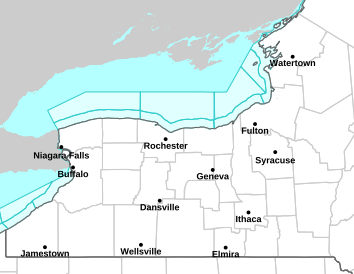
Current Watches, Advisories, and Warnings
Local Watches and Warnings
United States Watches and Warnings
Radar
Current Weather
Rivers & Lakes
Satellite
Forecast Maps
Hour by Hour Forecast
Winter Weather
Graphical Hazards
Montague Radar
Beach and Surf
Text Bulletins
Marine Forecasts
Skywarn
NOAA Weather Radio
Forecaster's Discussion
Fire Weather
Submit Storm Report
Climate Plots
Follow us on Twitter
Follow us on Facebook
Follow us on YouTube
BUF RSS Feed