
Extreme heat continues today from the central Plains to the lower Mississippi River Valley, over southeast Montana, and from southern California into the Southwest Deserts. Extreme Heat Warnings remain in effect. Severe thunderstorms capable of strong to severe wind gusts and large hail are possible across the Great Lakes into the Ohio Valley today into tonight. Read More >
Water Level rankings are rankings relative to the specific station. For example, Bangor's #2 rank on Jan 10 means this was the 2nd highest water level that gage has read, since records started there in 2012 (right column).
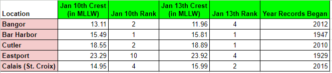
* Observed water levels are preliminary
If you have a coastal flood report you'd like to share with us, please feel free to send an email to nws.caribou@noaa.gov!
..TIME...   ...EVENT...      ...CITY LOCATION...     ...LAT.LON...
..DATE...   ....MAG....      ..COUNTY LOCATION..ST.. ...SOURCE....
            ..REMARKS..

0915 AM     Coastal Flood    Penobscot               44.46N 68.71W
01/10/2024                   Hancock            ME   Public

            Southern Bay Rd flooded.

0825 AM     Coastal Flood    3 NW Bar Harbor         44.42N 68.25W
01/10/2024                   Hancock            ME   Public

            Route 3 has water and debris on the road.

0843 AM     Coastal Flood    Seawall                 44.25N 68.30W
01/10/2024                   Hancock            ME   Trained Spotter

            Large rocks and water on Seawall Rd and is
            completely impassible.

0915 AM     Coastal Flood    4 SSW Brooklin          44.21N 68.60W
01/10/2024                   Hancock            ME   Public

            Sunshine Causeway inundated with 1-2 feet of
            water.

0915 AM     Coastal Flood    2 NE Stonington         44.18N 68.64W
01/10/2024                   Hancock            ME   Public

            Oceanville Causeway flooded to at least 3
            feet deep and possibly over 4 feet deep from
            surge waters moving from south to north over
            the causeway, carrying large chunks of marsh
            and other debris.

0915 AM     Coastal Flood    1 SSW Seawall           44.24N 68.30W
01/10/2024                   Hancock            ME   Public

            Video shows an estimated 2-3 feet of water
            over Seawall Road with property damage and
            water beginning to inundate structures.

0915 AM     Coastal Flood    1 SSW Tremont           44.24N 68.36W
01/10/2024                   Hancock            ME   Public

            Lopaus Point Rd inundated with several feet
            of fast-moving water, as seen on video on
            social media.

0915 AM     Coastal Flood    1 NW Castine            44.40N 68.81W
01/10/2024                   Hancock            ME   Fire Dept/Rescue

            Wadsworth Cove Rd washed out and closed
            until further notice due to potential for
            road collapse.

0915 AM     Coastal Flood    1 S Tremont             44.24N 68.35W
01/10/2024                   Hancock            ME   Public

            Dock house washed into the sea, as seen on
            videos on social media. Dock house was over
            100 years old.

0918 AM     Coastal Flood    Machias                 44.72N 67.45W
01/10/2024                   Washington         ME   911 Call Center

            Updates previous coastal flood report from
            Machias. Dike in Machias is closed due to
            water overtopping the dike. Court St is
            flooded as a result.

0920 AM     Coastal Flood    Milbridge               44.53N 67.88W
01/10/2024                   Washington         ME   Public

            Wyman Rd by Rt 1 under a few feet of water.

0920 AM     Coastal Flood    2 SE Milbridge          44.52N 67.86W
01/10/2024                   Washington         ME   Public

            Chipmans Wharf destroyed.

0925 AM     Coastal Flood    Brewer                  44.80N 68.77W
01/10/2024                   Penobscot          ME   Fire Dept/Rescue

            Water coming over the banks behind the
            Seadog restaurant.

0930 AM     Coastal Flood    1 SSE Trenton           44.43N 68.37W
01/10/2024                   Hancock            ME   911 Call Center

            Rt 3/Bar Harbor Road between Trenton and
            Mount Desert Island at least partially
            underwater with a lane closure.

0945 AM     Coastal Flood    1 NNE Swans Island      44.15N 68.45W
01/10/2024                   Hancock            ME   Broadcast Media

            Delayed report. Photo via social media
            showed a large section of a boat shop broke
            free and floating in the Swans Island
            harbor. Time estimated around High Tide.

0954 AM     Coastal Flood    Castine                 44.39N 68.80W
01/10/2024                   Hancock            ME   Fire Dept/Rescue

            Boatyard under 5 to 10 feet of water with
            structures and vehicles inundated and
            sustaining damage.

1000 AM     Coastal Flood    Winter Harbor           44.39N 68.08W
01/10/2024                   Hancock            ME   Public

            Multiple structures inundated in downtown
            Winter Harbor.

1000 AM     Coastal Flood    Orland                  44.57N 68.74W
01/10/2024                   Hancock            ME   Fire Dept/Rescue

            Orland River out of its banks with
            inundation of a building near Castine Road.
            Flooding due to tidal surge up the river.

1000 AM     Coastal Flood    4 WSW Sedgwick          44.29N 68.69W
01/10/2024                   Hancock            ME   Public

            Video shows approximately a foot of water
            over Little Deer Isle Rd at the southwestern
            end of the Deer Isle Bridge.

1013 AM     Coastal Flood    1 E Southwest Harbor    44.28N 68.31W
01/10/2024                   Hancock            ME   Public

            Delayed Report. Photo via social media
            showed 6-12 inches of flooding of the Clark
            Point Road point at the US Coast Guard
            Station.

1028 AM     Coastal Flood    Milbridge               44.54N 67.88W
01/10/2024                   Washington         ME   Amateur Radio

            Corrects time of previous coastal flood
            report from Milbridge. Tidal flooding of the
            Narraguagus River in downtown Milbridge.

1030 AM     Coastal Flood    1 ENE Machias           44.72N 67.45W
01/10/2024                   Washington         ME   Fire Dept/Rescue

            US-1 closed in Machias with at least a foot
            of water across the road. Photo shows
            vehicles and structures inundated.

1031 AM     Coastal Flood    5 S Milbridge           44.46N 67.88W
01/10/2024                   Washington         ME   Amateur Radio

            Most piers destroyed in Pigeon Hill Bay.

1033 AM     Coastal Flood    1 WSW Seal Harbor       44.29N 68.26W
01/10/2024                   Hancock            ME   Trained Spotter

            Updates previous coastal flood report from 1
            WSW Seal Harbor. Rt 3/Peabody Rd completely
            washed out at Barley Beach/Little Long Pond.

1047 AM     Coastal Flood    1 SSE Addison           44.60N 67.74W
01/10/2024                   Washington         ME   Emergency Mngr

            East Side Rd underwater.

1048 AM     Coastal Flood    Brewer                  44.79N 68.77W
01/10/2024                   Penobscot          ME   Public

            Delayed Report. Brewer waterfront park
            walking path inundated at the time of high
            tide.

1048 AM     Coastal Flood    1 NNW Milbridge         44.55N 67.89W
01/10/2024                   Washington         ME   Emergency Mngr

            Kansas Rd in Milbridge underwater.

1100 AM     Coastal Flood    Bangor                  44.80N 68.77W
01/10/2024                   Penobscot          ME   Fire Dept/Rescue

            Parking garage flooding due to upriver
            surge. Propane tanks and dumpsters floated.
            Time estimated.

1100 AM     Coastal Flood    Bangor                  44.80N 68.77W
01/10/2024                   Penobscot          ME   Fire Dept/Rescue

            Maine Judicial Center parking lot flooded
            due to upriver surge. Time estimated.

1125 AM     Coastal Flood    Roque Bluffs            44.62N 67.48W
01/10/2024                   Washington         ME   Emergency Mngr

            State Park in Roque Bluffs is underwater
            with the dune gone. Johnson Cove Rd is
            underwater leaving people stranded on the
            other side. Rip rap is on the road. Side of
            Schoppee Point road partially collapsed.
            Three telephone poles down.

0120 PM     Coastal Flood    4 SSE Winter Harbor     44.34N 68.05W
01/10/2024                   Hancock            ME   Other Federal

            Big boulder on Schoodic Loop Rd with
            significant damage to the road. Lots of rip
            rap on the surface.

0300 PM     Coastal Flood    1 SSW Seawall           44.24N 68.30W
01/10/2024                   Hancock            ME   Trained Spotter

            Seawall Rd remains flooded with extensive
            damage to the road and subsurface.

0900 AM     Coastal Flood    3 SW Sorrento           44.47N 68.23W
01/10/2024                   ANZ052             ME   Trained Spotter

            Hancock Point pier washed out at high tide.

0905 AM     Coastal Flood    4 S East Surry          44.44N 68.47W
01/10/2024                   ANZ052             ME   Fire Dept/Rescue

            Road closed due to multiple trees and power
            lines down and surge overtopping road with
            small rocks.

0910 AM     Coastal Flood    4 WSW Sedgwick          44.28N 68.68W
01/10/2024                   ANZ052             ME   Fire Dept/Rescue

            Deer Isle Causeway closed due to water
            overtopping the causeway. Video from Deer
            Isle Fire Dept social media.

0915 AM     Coastal Flood    2 ENE Seal Harbor       44.32N 68.20W
01/10/2024                   ANZ052             ME   Public

            Otter Cove Causeway on Park Loop Rd has very
            large boulders and some trees deposited onto
            it.
..TIME...   ...EVENT...      ...CITY LOCATION...     ...LAT.LON...
..DATE...   ....MAG....      ..COUNTY LOCATION..ST.. ...SOURCE....
            ..REMARKS..

1145 AM     Coastal Flood    Penobscot               44.46N 68.71W
01/13/2024                   Hancock            ME   Public

            Southern Bay Rd flooded, but not as deep as
            Jan 10.

1035 AM     Coastal Flood    4 WSW Sedgwick          44.28N 68.68W
01/13/2024                   Hancock            ME   Fire Dept/Rescue

            Deer Isle Causeway closed due to flooding.

1105 AM     Coastal Flood    Stonington              44.16N 68.66W
01/13/2024                   Hancock            ME   Public

            Parking lot on west side of Atlantic Ave
            flooded up to base of businesses.

1114 AM     Coastal Flood    1 ENE Machias           44.72N 67.45W
01/13/2024                   Washington         ME   911 Call Center

            The Dike closed due to flooding.

1116 AM     Coastal Flood    1 SSW Seawall           44.24N 68.30W
01/13/2024                   Hancock            ME   Public

            Water has breached the road and is flowing
            into the pond.

1130 AM     Coastal Flood    Calais                  45.19N 67.28W
01/13/2024                   Washington         ME   Public

            Minor flooding of waterfront park at high
            tide.

1145 AM     Coastal Flood    1 SE Southwest Harbor   44.27N 68.31W
01/13/2024                   Hancock            ME   Public

            Shore Rd Manset area of Southwest Harbor
            flooded with water lapping at several
            structures.

1145 AM     Coastal Flood    Seal Harbor             44.30N 68.24W
01/13/2024                   Hancock            ME   Public

            Numerous small rocks and vegetation
            deposited on Peabody Dr by Seal Harbor
            Beach.

1145 AM     Coastal Flood    2 ESE Lamoine           44.47N 68.28W
01/13/2024                   Hancock            ME   Public

            Marlboro Beach Rd badly damaged.

1145 AM     Coastal Flood    2 NE Cranberry Isles    44.26N 68.24W
01/13/2024                   Hancock            ME   Public

            Isleford Dock Restaurant flooded.

1145 AM     Coastal Flood    3 SW Sorrento           44.47N 68.23W
01/13/2024                   Hancock            ME   Public

            Structure at Hancock Town Pier inundated.

1200 PM     Coastal Flood    Milbridge               44.53N 67.88W
01/13/2024                   Washington         ME   Public

            Wyman Rd flooded near the intersection with
            US-1/Main St.

1200 PM     Coastal Flood    Lubec                   44.86N 66.98W
01/13/2024                   Washington         ME   Public

            Several structures flooded on Water St near
            the intersection of Mowry St.

1200 PM     Coastal Flood    Eastport                44.91N 66.98W
01/13/2024                   Washington         ME   Public

            Chowderhouse Pier destroyed.

1200 PM     Coastal Flood    Pembroke                44.95N 67.16W
01/13/2024                   Washington         ME   Public

            Shore Rd flooded.

1200 PM     Coastal Flood    3 NE Edmunds            44.90N 67.11W
01/13/2024                   Washington         ME   Public

            Southern end of Leighton Point Rd flooded.

1200 PM     Coastal Flood    3 NW Eastport           44.93N 67.04W
01/13/2024                   Washington         ME   Public

            Water over Toll Bridge rd.

1200 PM     Coastal Flood    Winter Harbor           44.39N 68.08W
01/13/2024                   Hancock            ME   Public

            Main St in downtown Winter Harbor flooded to
            a depth of about 3 feet.

1200 PM     Coastal Flood    Tremont                 44.25N 68.35W
01/13/2024                   Hancock            ME   Public

            Intersection of Flat Iron and Tremont Rd
            flooded.

1200 PM     Coastal Flood    Machias                 44.72N 67.46W
01/13/2024                   Washington         ME   Public

            Extensive flooding in downtown Machias,
            though not quite as bad as Jan 10.

1200 PM     Coastal Flood    Bucksport               44.57N 68.79W
01/13/2024                   Hancock            ME   Public

            Flooding of Veterans Park and riverfront
            walkway at high tide.

1214 PM     Coastal Flood    Castine                 44.39N 68.80W
01/13/2024                   Hancock            ME   Fire Dept/Rescue

            Dock is flooded and closed.

1230 PM     Coastal Flood    1 W Roque Bluffs        44.61N 67.49W
01/13/2024                   Washington         ME   Trained Spotter

            Video and photos show significant coastal
            erosion and some additional damage occurring
            to stairs near the beach that were damaged
            January 10th.

1245 PM     Coastal Flood    3 SW Brooklin           44.23N 68.61W
01/13/2024                   Hancock            ME   Public

            Water over Reach Rd at Oak Point Causeway.


 Coastal Flood