
Heat expands across the Desert Southwest, Plains, Mississippi Valley and Midwest into Monday. Fire weather concerns continue for portions of the Intermountain West. Active monsoonal moisture fuels thunderstorms over the Southwest with possible flash flooding. Tropical cyclone Fausto in the Pacific, should weaken as it approaches Hawaii; Dangerous surf, swells and rip currents are expected. Read More >

...PRECIPITATION REPORTS FROM DEC 17-18, 2023 STORM...

Location                     Amount    Time/Date       Provider

...Maine...

...Aroostook County...
1 E Orient                   2.10 in   0800 AM 12/19   Trained Spotter
Westfield NERON Site         1.99 in   0800 AM 12/19   HADS
3 WNW Oxbow                  1.92 in   0700 AM 12/19   Mesonet
Linneus                      1.66 in   1030 AM 12/19   CWOP
1 NNW Macwahoc               1.61 in   0824 AM 12/19   Trained Spotter
Clayton Lake                 1.58 in   0700 AM 12/19   AWOS
1 S Houlton                  1.58 in   0725 AM 12/19   Trained Spotter
Presque Isle 1.3 WSW         1.55 in   0700 AM 12/19   COCORAHS
1 E Houlton                  1.49 in   0700 AM 12/19   ASOS
0.9 E Eagle Lake             1.37 in   0945 AM 12/19   COOP
3 WSW Fish River Lake        1.30 in   0700 AM 12/19   Public
AROOSTOOK NWR LIMESTONE 4 NN 1.28 in   1005 AM 12/19   HADS
Grand Isle                   1.21 in   1016 AM 12/19   CWOP
3 NW Caribou                 1.20 in   0828 AM 12/19   Trained Spotter
Fort Kent 1 SE               1.19 in   0700 AM 12/19   COOP
2 SSE Castle Hill            1.10 in   0700 AM 12/19   COCORAHS
New Sweden 4.9 NNW           1.06 in   0630 AM 12/19   COCORAHS
CARIBOU                      0.98 in   1030 AM 12/19   CWOP
Caribou                      0.95 in   0700 AM 12/19   ASOS
Frenchville Airport          0.94 in   0700 AM 12/19   ASOS
Caribou                      0.86 in   1025 AM 12/19   CWOP
Dickey                       0.79 in   0700 AM 12/19   Mesonet
Westmanland 2.9 N            0.77 in   0700 AM 12/19   COCORAHS
Woodland                     0.66 in   1028 AM 12/19   CWOP
Van Buren 1 NNE              0.60 in   0700 AM 12/19   COOP

...Hancock County...
Otis                         2.83 in   1026 AM 12/19   CWOP
Mariaville 1.4 ESE           2.21 in   0800 AM 12/19   COCORAHS
Bar Harbor                   1.85 in   1005 AM 12/19   CWOP
Blue Hill 4 SSE              1.50 in   0700 AM 12/19   CWOP
Surry                        1.50 in   1015 AM 12/19   CWOP
East Surry                   1.46 in   0800 AM 12/19   COCORAHS
East Surry                   1.43 in   1015 AM 12/19   CWOP
Sedgwick Ridge               1.27 in   0700 AM 12/19   CWOP
Surry 2.5 SSE                1.27 in   0845 AM 12/19   COCORAHS
Acadia National Park         1.27 in   0958 AM 12/19   RAWS
Mount Desert 2.3 NE          1.17 in   0700 AM 12/19   COCORAHS
Southwest Harbor 0.9 NW      1.16 in   0700 AM 12/19   COCORAHS
Deer Isle 1.5 NNE            0.84 in   1015 AM 12/19   CWOP
Winter Harbor-SERC           0.82 in   1017 AM 12/19   CWOP
Brooklin School              0.77 in   0700 AM 12/19   CWOP
Brooksville - 3.5 ESE        0.75 in   1015 AM 12/19   CWOP

...Penobscot County...
Grand Lake Matagamon Dam     3.81 in   0700 AM 12/19   Park/Forest Srvc
Greenfield                   2.83 in   1015 AM 12/19   CWOP
3 NW Patten                  2.73 in   0700 AM 12/19   Mesonet
Alton                        2.62 in   1015 AM 12/19   CWOP
Bangor International Airport 2.57 in   0700 AM 12/19   ASOS
Millinocket                  2.56 in   0700 AM 12/19   ASOS
ROGERS FARM SITE OLD TOWN 2  2.50 in   1005 AM 12/19   HADS
2 ESE Hudson                 2.40 in   1114 AM 12/19   Trained Spotter
Kenduskeag                   2.37 in   1030 AM 12/19   CWOP
Glenburn 1.5 ENE             2.36 in   0700 AM 12/19   COCORAHS
Hermon 1.2 W                 2.36 in   0750 AM 12/19   COCORAHS
Orono 0.6 N                  2.20 in   0700 AM 12/19   COCORAHS
Lincoln 5 SW                 2.05 in   0741 AM 12/19   COOP
4 ESE Orrington              1.84 in   1030 AM 12/19   AWS
0.9 N Lincoln                1.81 in   0700 AM 12/19   COOP
Orono                        1.67 in   1025 AM 12/19   CWOP
Bangor 1.7 ESE               1.49 in   0700 AM 12/19   COCORAHS
Milford                      1.43 in   0758 PM 12/18   Trained Spotter

...Piscataquis County...
East Sangerville             5.38 in   0700 AM 12/19   COOP
Greenville                   4.63 in   0700 AM 12/19   ASOS
2 SSE Kingsbury              4.25 in   1048 AM 12/19   Trained Spotter
Shirley                      4.10 in   0945 AM 12/19   HADS
Abbot 4.6 WNW                3.89 in   0700 AM 12/19   COCORAHS
Beaver Cove                  3.52 in   1030 AM 12/19   CWOP
Ripogenus                    3.49 in   0700 AM 12/19   Mesonet
Dover-foxcroft 2 E           2.27 in   0700 AM 12/19   COOP

...Somerset County...
St. Zacharie Crossing        1.34 in   0945 AM 12/19   HADS

...Washington County...
Baring                       2.89 in   0415 PM 12/18   CWOP
Moosehorn                    2.57 in   1019 AM 12/19   RAWS
3 WNW Princeton              2.46 in   0700 AM 12/19   Mesonet
1.3 NE Topsfield             2.10 in   0700 AM 12/19   COOP
Robbinston                   1.91 in   1158 PM 12/18   COOP
1 S Cooper                   1.74 in   0700 AM 12/19   Mesonet
2 S Whitneyville             1.68 in   0700 AM 12/19   Mesonet
Vanceboro                    1.43 in   1015 AM 12/19   USGS
3 NNE Whiting                1.05 in   0827 AM 12/19   Trained Spotter
Eastport 1.4 ESE             0.92 in   0700 AM 12/19   COCORAHS
Whiting 2.3 WSW              0.75 in   0700 AM 12/19   COCORAHS

...Maritime Stations...
BLUE HILL                    0.97 in   0700 AM 12/19   CWOP
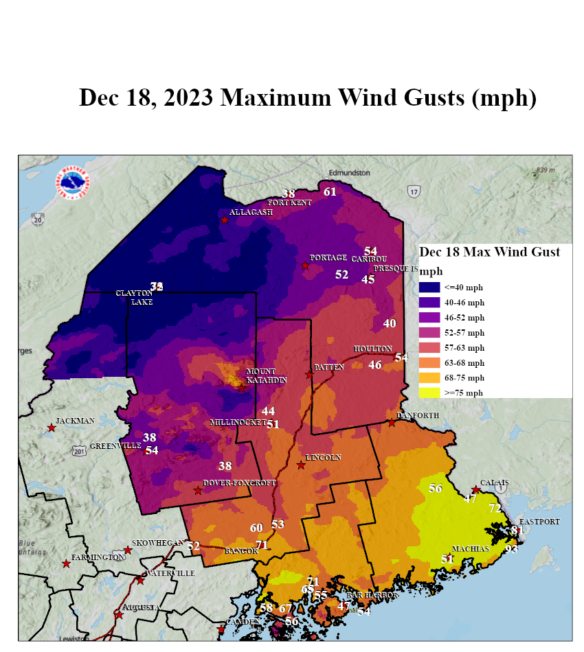
...HIGHEST WIND REPORTS FROM DECEMBER 18, 2023 STORM...

Location                     Speed     Time/Date       Provider

...Maine...

...Aroostook County...
Frenchville Airport          61 MPH    0713 PM 12/18   ASOS
Caribou                      54 MPH    0402 PM 12/18   ASOS
1 E Houlton                  54 MPH    0622 PM 12/18   ASOS
2 SSE Castle Hill            52 MPH    0430 PM 12/18   NWS Employee
Linneus                      46 MPH    0845 PM 12/18   CWOP
Presque Isle Airport         45 MPH    0230 PM 12/18   AWOS
Monticello                   40 MPH    0138 PM 12/18   CWOP
Fort Kent                    38 MPH    1134 PM 12/18   AWOS
CARIBOU                      37 MPH    0700 PM 12/18   CWOP
Bridgewater                  37 MPH    0830 PM 12/18   DAVIS
Caribou                      36 MPH    0738 PM 12/18   CWOP
Clayton Lake                 35 MPH    1109 AM 12/18   AWOS

...Hancock County...
Ellsworth                    71 MPH    0145 PM 12/18   Public
Sedgwick Ridge               67 MPH    0415 PM 12/18   CWOP
East Surry                   65 MPH    0456 PM 12/18
Brooksville - 3.5 ESE        58 MPH    0645 PM 12/18   CWOP
Brooklin School              56 MPH    1230 PM 12/18   CWOP
Bar Harbor Airport           55 MPH    1133 AM 12/18   AWOS
Winter Harbor-SERC           54 MPH    0147 PM 12/18   CWOP
Bar Harbor, ME               51 MPH    0754 PM 12/18   NOS-NWLON
Naskeag                      50 MPH    1253 PM 12/18   CWOP
Blue Hill                    50 MPH    0400 PM 12/18   CWOP
Southwest Hbr.-Seawall       50 MPH    0410 PM 12/18   CWOP
East Surry                   49 MPH    0445 PM 12/18   CWOP
Bar Harbor                   47 MPH    0617 PM 12/18   CWOP
Acadia National Park         47 MPH    0858 PM 12/18   RAWS
Surry                        42 MPH    0400 PM 12/18   CWOP
Lamoine                      39 MPH    0150 PM 12/18   CWOP

...Penobscot County...
Bangor                       71 MPH    0426 PM 12/18   ASOS
Bangor                       68 MPH    0510 PM 12/18   CWOP
2 NE Glenburn                60 MPH    0110 PM 12/18   CWOP
2 N Bangor                   57 MPH    0304 PM 12/18   Trained Spotter
1.1 W Milford                53 MPH    0430 PM 12/18   MESOWEST
Plymouth                     52 MPH    1058 AM 12/18   CWOP
Millinocket                  51 MPH    1130 AM 12/18   ASOS
Millinocket                  44 MPH    0235 PM 12/18   CWOP
Orono                        42 MPH    0533 PM 12/18   CWOP

...Piscataquis County...
Greenville                   54 MPH    1234 PM 12/18   ASOS
1 E Greenville               51 MPH    0554 PM 12/18   AWOS
1.0 NE Brownville Junction   38 MPH    0515 PM 12/18   MESOWEST
Beaver Cove                  38 MPH    0620 PM 12/18   CWOP

...Washington County...
2 E Trescott                 93 MPH    0409 PM 12/18   Trained Spotter
Eastport                     81 MPH    0630 PM 12/18   NOS-NWLON
8 NE Charlotte               72 MPH    0900 PM 12/18   CO-OP Observer
1 W Eastport                 66 MPH    0635 PM 12/18   Mesonet
Eastport                     61 MPH    0100 PM 12/18   Trained Spotter
1 SSE Princeton              56 MPH    0104 PM 12/18   AWOS
1 SW Machias                 51 MPH    0631 PM 12/18   AWOS
Marshfield                   49 MPH    0504 PM 12/18   CWOP
1 W Eastport                 48 MPH    1257 PM 12/18   AWOS
Baring                       47 MPH    0145 PM 12/18   CWOP
Cutler Farris Wharf          43 MPH    0906 PM 12/18   NOS-NWLON
Moosehorn                    42 MPH    1219 PM 12/18   RAWS

...Maritime Stations...
15 ESE Frenchboro            69 MPH    0500 PM 12/18   NDBC
BLUE HILL                    64 MPH    0500 PM 12/18   CWOP
24 SSE Roque Bluffs          63 MPH    0630 PM 12/18   NDBC
12 SE Cranberry Isles        56 MPH    0704 PM 12/18   NDBC
Gouldsboro                   51 MPH    0615 PM 12/18   DAVIS


 Coastal Flood