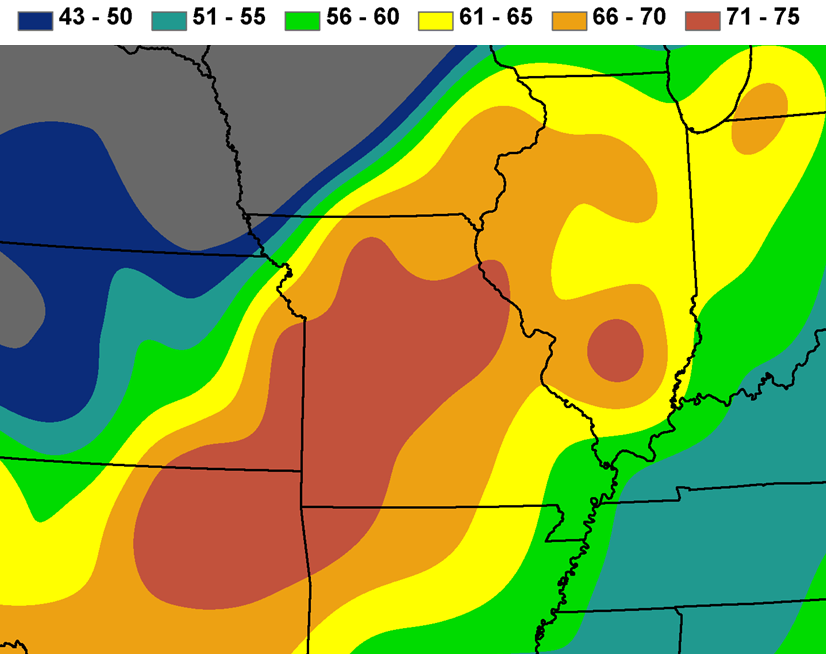
On November 11, 1911, a very strong cold front produced unprecedented temperature falls across most of the central U.S. as well as widespread damaging winds and severe thunderstorms. A large area of low pressure, stretching from Wisconsin southwest across Iowa and into Kansas, had been nearly stationary for a couple of days allowing a long cold front to sharpen across the region as warm air was pumped up ahead of the system, and unseasonably cold air flowed in behind it. On the 11th the low pressure center and cold front advanced across southeastern Iowa and the rest of the Midwest, reaching the Ohio River Valley by sunset.
The passage of this cold front was historic for the rapidity of temperature falls behind it. Most of Iowa was already behind the front on the 11th so temperatures never warmed substantially. However, in the southeast, abundant sunshine and southerly breezes ahead of the front brought temperatures up into the 70s before midday. Between about noon and 2:00 pm the front swept through that corner of the state with rain showers changing to sleet and then snow. At Albia, the temperature rose to 72°F by late morning, then the front moved through and blizzard conditions were reported in the afternoon as the temperature fell to 5°F by 9:00 pm, making a drop of 67°F in less than 12 hours. At Keokuk, the temperature peaked at 79°F just after noon, then as the front moved through it fell by 37°F in one hour and reached 14°F at midnight with an inch of sleet falling in the evening. The high temperature at Keokuk the following day was only 17°F. Talk about extremes!
Further south and east temperature falls were even more pronounced across parts of Illinois, Missouri, and Oklahoma. At Oklahoma City, OK and Springfield, MO the daily record high and low temperatures for November 11 were both set in 1911 and have been unmatched in 100+ years since. At Springfield the temperature reached 80°F at just after 3:00 pm, then the front moved through at 3:45 pm and the temperature fell by nearly 40°F in just 15 minutes. The temperature then to 21°F at 7:00 pm and 13°F at midnight in Springfield. Winds gusted to as high as 74 mph behind the front while reports of rain, hail, sleet and snow all occurred within a period of less than two hours.
Across parts of Wisconsin, Illinois, Indiana, and Michigan the passage of the front was accompanied by severe thunderstorms and tornadoes. Several tornadoes produced F3 or F4 damage with fatalities as far north as Wisconsin. A weaker tornado was also observed just west and northwest of Davenport. Strong winds behind the front resulted in numerous injuries and widespread damage to farm buildings, trees, windmills, utility lines, etc. In Chicago a man died from heat stroke on November 11, then two people froze to death the following day. Many of the records set during the Great Blue Norther of 1911 have not been equaled in a century, and those who experienced it remembered that day for the rest of their lives.
