Below is information on the storm damage surveys conducted by the National Weather Service in Des Moines, Iowa.
A total of 17 tornadoes touched down in Iowa on April 9, with 12 of these tornadoes occurring in the Des Moines NWS CWA.
The tornado that touched down west of Pocahontas and moved east southeast was given an EF4 rating. This is the strongest tornado to hit Iowa since the EF4 tornado that touched down near Sibley, Iowa in June 2010. Fortunately people were able to take cover in their basements and there were no injuries with this violent tornado.
Thank you to the property owners who allowed us on to their properties to document and photograph the damage they experienced.
For reference, the Enhanced Fujita tornado scale classifies tornadoes into the following categories:
- EF0: wind speeds of 65 to 85 mph.
- EF1: wind speeds of 86 to 110 mph.
- EF2: wind speeds of 111 to 135 mph.
- EF3: wind speeds of 136 to 165 mph.
- EF4: wind speeds of 166 to 200 mph.
- EF5: wind speeds of greater than 200 mph.
Click on an map or photo below to view a larger version
Map of all Tornadoes from April 9, 2011
Click to enlarge--Does not include the
Crawford County tornado.
|
Radar Loop from 7:00pm to 12:00am
Click to load loop--May take a few
minutes to load.
|
| Tornado Track |
Damage Photos |
|
.jpg)
|
|
Quick facts:
- Event date: April 9, 2011
- Event time: 8:23 PM to 8:55 PM CDT
- Intensity rating: EF3
- Event location: Sac County - Started about 3 miles NW of Odebolt and ended about 1.5 miles east of Schaller.
- Peak wind: 140 mph
- Peak path width: 1 mile
- Path length: 10.14 miles
- Injuries: None known
- Fatalities: 0
| Tornado Track |
Damage Photos |
|
|
|
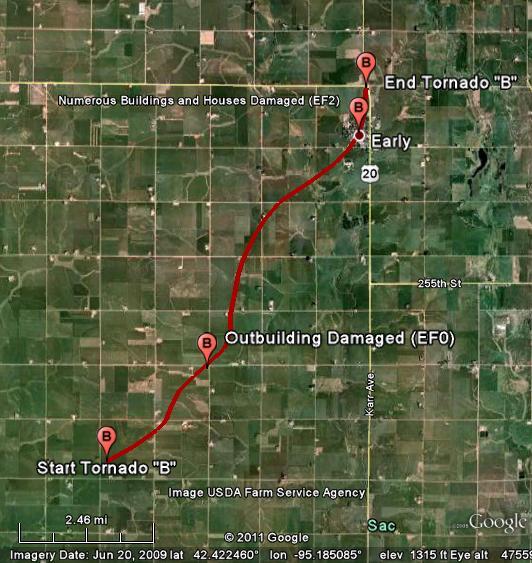
Quick facts:
- Event date: April 9, 2011
- Event time: 8:29 PM to 8:54 PM CDT
- Intensity rating: EF2
- Event location: Sac County - Started around 4.5 miles north of Odebolt and ended just north of Early.
- Peak wind: 132 mph
- Peak path width: 660 yards
- Path length: 8.34 miles
- Injuries: None known
- Fatalities: 0
| Tornado Track |
|
|
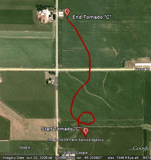
Quick facts:
- Event date: April 9, 2011
- Event time: 8:38 PM to 8:40 PM CDT
- Intensity rating: EF0
- Event location: Sac County - About 5 miles southwest of Early
- Peak wind: 70 mph
- Peak path width: 100 yards
- Path length: 0.75 miles
- Injuries: 0
- Fatalities: 0
- Additional notes: This was a satellite tornado of the tornado which passed through Early. This tornado did a small loop shortly after forming as it moved just west of due north.
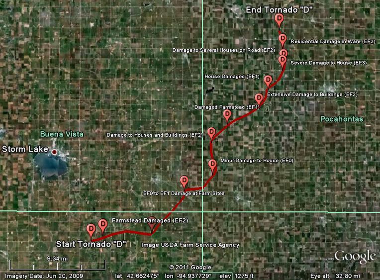
Tornado "D"--Sac, Buena Vista, and Pocahontas Counties
|
| Tornado Track |
Damage Photos |
|
|
|
Quick facts:
- Event date: April 9, 2011
- Event time: 9:08 PM to 10:07PM CDT
- Intensity rating: EF3
- Event location: Sac, Buena Vista and Pocahontas Counties
- Peak wind: 140 mph
- Peak path width: 1.5 miles
- Path length: About 30 miles
- Injuries: A few minor injuries
- Fatalities: 0
- Additional notes: This long track tornado was on the ground nearly an hour and tracked through 3 counties. The tornado produced numerous satellite tornadoes as it moved to the northeast.
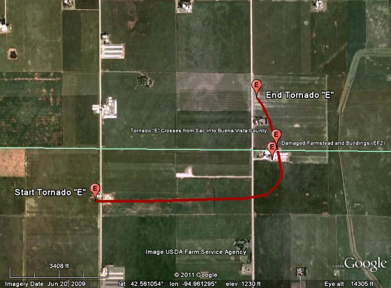
Tornado "E"-- Sac and Buena Vista Counties
|
| Tornado Track |
|
|
Quick facts:
- Event date: April 9, 2011
- Event time: 9:24PM to 9:27PM CDT
- Intensity rating: EF2
- Event location: Northern Sac and far Southeastern Buena Vista Counties
- Peak wind: 115 mph
- Peak path width: 220 yards
- Path length: 1.75 miles
- Injuries: None known
- Fatalities: 0
- Additional notes: This was the first satellite tornado of Tornado D.
Tornado "F"-- Crawford County
|
Brief touchdown--no map or damage photos available.
Quick facts:
- Event date: April 9, 2011
- Event time: 7:37PM to 7:38PM CDT
- Intensity rating: EF1
- Event location: 6 miles northwest of Ricketts
- Peak wind: 90 mph
- Peak path width: 75 yards
- Path length: 0.69 miles
- Injuries: 0
- Fatalities: 0
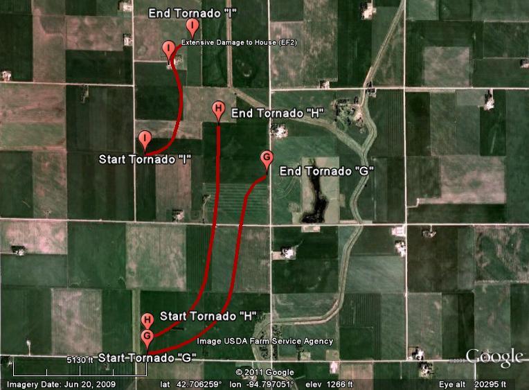
Tornadoes "G, H and I"-- Pocahontas County
|
| Tornado Tracks |
|
|
Quick facts:
Tornado G
- Event date: April 9, 2011
- Event time: 9:55PM to 9:58PM CDT
- Intensity rating: EF1
- Event location: Pocahontas County - About 8 miles west southwest of Pocahontas
- Peak wind: 90 mph
- Peak path width: 100 yards
- Path length: 1.5 miles
- Injuries: 0
- Fatalities: 0
Tornado H
- Event date: April 9, 2011
- Event time: 9:55PM to 9:58PM CDT
- Intensity rating: EF1
- Event location: Pocahontas County - About 8 miles west southwest of Pocahontas
- Peak wind: 90 mph
- Peak path width: 100 yards
- Path length: 1.6 miles
- Injuries: 0
- Fatalities: 0
Tornado I
- Event date: April 9, 2011
- Event time: 9:56PM to 9:57PM CDT
- Intensity rating: EF2
- Event location: Pocahontas County - About 8 miles west of Pocahontas
- Peak wind: 115 mph
- Peak path width: 146 yards
- Path length: 0.9 miles
- Injuries: 0
- Fatalities: 0
Additional notes: Tornadoes G and H were a cyclonic/anticyclonic pair. G was the anticyclonic tornado. These were all satellite tornadoes to Tornado D.
Tornado "J"-- Pocahontas County
|
| Tornado Track |
Damage Photos |
|

|
|
Quick facts:
- Event date: April 9, 2011
- Event time: 9:54PM to 10:01PM CDT
- Intensity rating: EF4
- Event location: Western Pocahontas county about 10 miles west of Pocahontas
- Peak wind: 170 mph
- Peak path width: 587 yards
- Path length: 3.2 miles
- Injuries: 0
- Fatalities: 0
- Additional notes: This tornado produced low end EF4 damage as determined by the NWS Des Moines office, and in collaboration with multiple wind damage experts. A special thanks to the Iowa Civil Air Patrol for assisting with this survey.
Tornado "K"--Pocahontas County
|
| Tornado Track |
|

|
Quick facts:
- Event date: April 9, 2011
- Event time: 10:08PM to 10:13PM CDT
- Intensity rating: EF1
- Event location: Pocahontas County - About 3 miles west of Pocahontas
- Peak wind: 95 mph
- Peak path width: 250 yards
- Path length: 2.4 miles
- Injuries: 0
- Fatalities: 0
Tornado "L"--Kossuth County
|
| Tornado Track |
Damage Photos |
|

|
|
Quick facts:
- Event date: April 9, 2011
- Event time: 11:19 PM to 11:21 PM CDT
- Intensity rating: EF1
- Event location: Kossuth County - About 10 miles south of Algona
- Peak wind: 90 mph
- Peak path width: 100 yards
- Path length: 0.8 miles
- Injuries: None known
- Fatalities: None known