Scattered thunderstorms with severe gusts, hail and a tornado risk are possible near a cold front from the Ohio Valley to the Mid-Atlantic tonight. Tropical Storm Bertha is expected to bring tropical storm conditions to portions of the Gulf Coast from the panhandle of Florida into Louisiana through Wednesday. Read More >
Overview
|
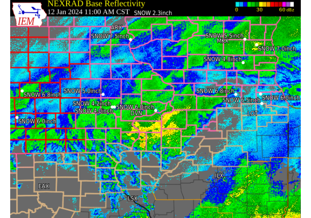
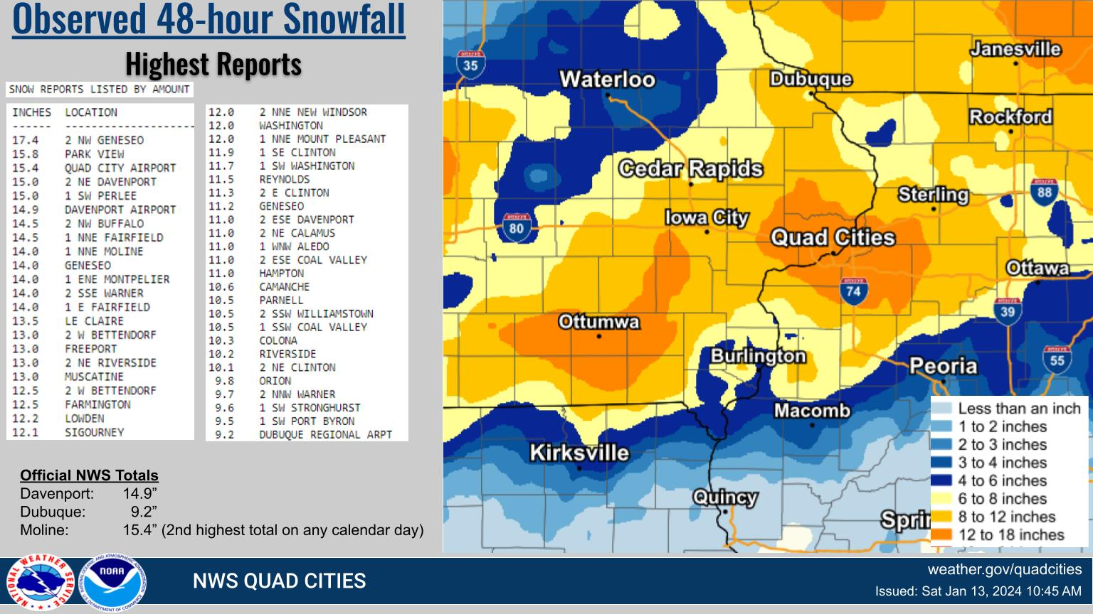
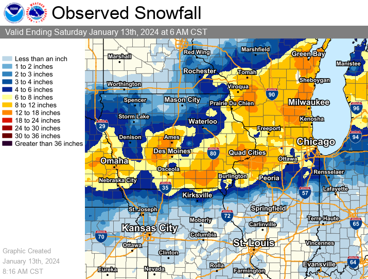
A significant winter storm brought heavy snow and near to blizzard conditions across all of eastern IA, northwest IL, and northeast MO on Friday, January 12. Snowfall amounts between 7 and 15 inches were common, with the higher end of the snowfall totals observed mainly along a line from the Quad Cities metro westward to Fairfield IA. NWS Official Totals Dubuque: 9.2" |
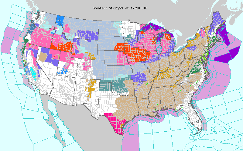 Watch, Warning Advisory Map at Noon Jan 12th, 2024 |
Fast Facts
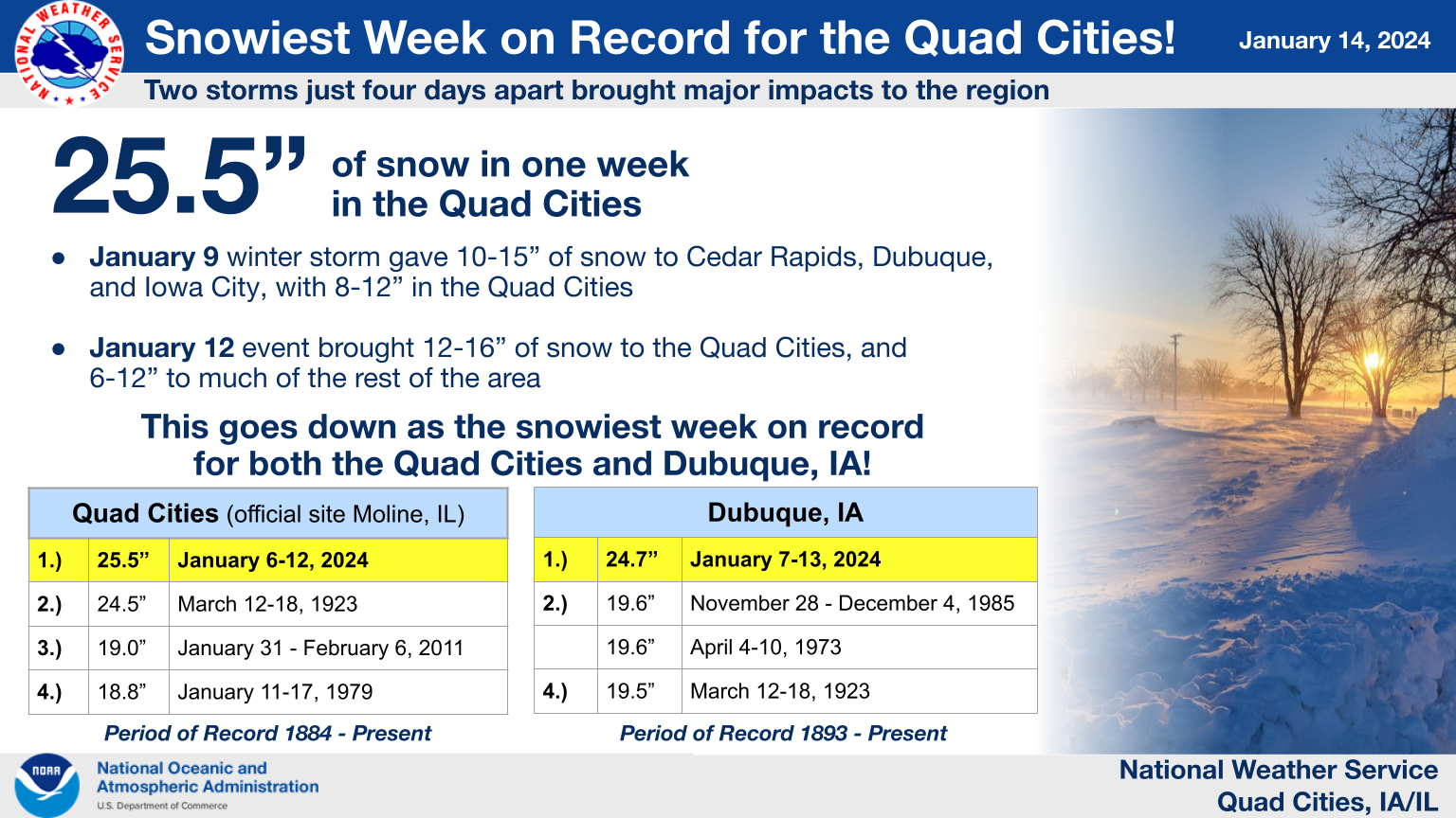
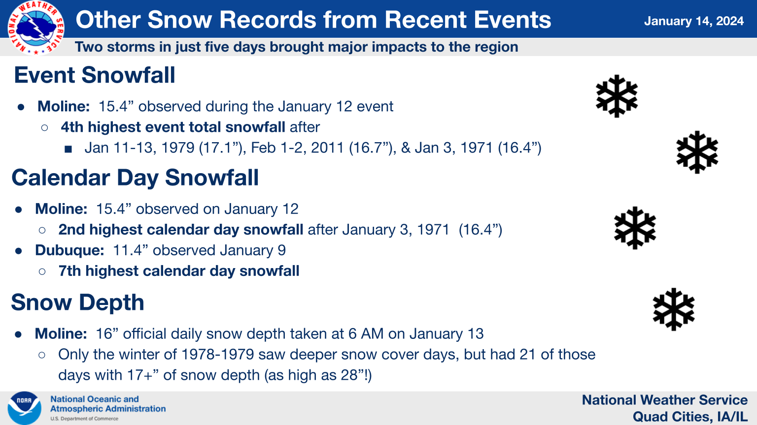
Moline, IL: 4th highest event snowfall (records date back to 1884)
Moline, IL: 2nd highest snowfall for a calendar day on record after January 3, 1971
Second winter storm within the week after the January 9 event, which made for the snowiest week on record for both Moline, IL and Dubuque, IA!
 |
 |
Snow
Snowfall Maps
| Local Snowfall Map | |
 |
|
| Regional Snowfall Map | |
 |
|
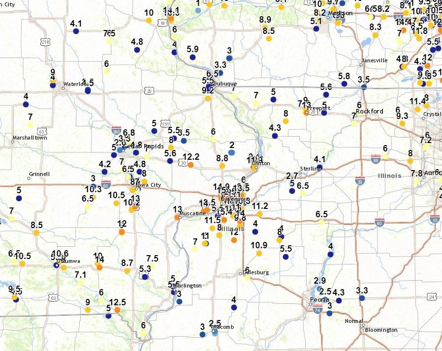
| Local Storm Report Map | |
 |
Snowfall Reports
Public Information Statement
National Weather Service Quad Cities IA IL
1005 AM CST Sat Jan 13 2024

...Highest Snowfall Amounts From January 12th-13th Winter Storm...

Data is through 930 AM on January 13. Observations are collected
from a variety of sources with varying equipment and exposures.
Not all data listed are considered official.

SNOW REPORTS LISTED BY AMOUNT

 INCHES  LOCATION                 ST  COUNTY           TIME
 ------  -----------------------  --  --------------   -------
 17.4    2 NW GENESEO             IL  HENRY            0700 AM
 15.8    PARK VIEW                IA  SCOTT            0700 AM
 15.4    QUAD CITY AIRPORT        IL  ROCK ISLAND      0600 AM
 15.0    2 NE DAVENPORT           IA  SCOTT            0830 PM
 15.0    1 SW PERLEE              IA  JEFFERSON        1100 AM
 14.9    DAVENPORT AIRPORT        IA  SCOTT            0600 AM
 14.5    2 NW BUFFALO             IA  SCOTT            0845 AM
 14.5    1 NNE FAIRFIELD          IA  JEFFERSON        0800 AM
 14.0    1 NNE MOLINE             IL  ROCK ISLAND      0700 AM
 14.0    GENESEO                  IL  HENRY            1200 AM
 14.0    1 ENE MONTPELIER         IA  SCOTT            0730 PM
 14.0    2 SSE WARNER             IL  HENRY            0513 PM
 14.0    1 E FAIRFIELD            IA  JEFFERSON        0405 PM
 13.5    LE CLAIRE                IA  SCOTT            0555 PM
 13.0    2 W BETTENDORF           IA  SCOTT            0730 AM
 13.0    FREEPORT                 IL  STEPHENSON       0652 AM
 13.0    2 NE RIVERSIDE           IA  WASHINGTON       0245 PM
 13.0    MUSCATINE                IA  MUSCATINE        0106 PM
 12.5    2 W BETTENDORF           IA  SCOTT            0932 PM
 12.5    FARMINGTON               IA  VAN BUREN        0603 PM
 12.2    LOWDEN                   IA  CEDAR            1215 AM
 12.1    SIGOURNEY                IA  KEOKUK           0800 AM
 12.0    2 NNE NEW WINDSOR        IL  MERCER           0430 PM
 12.0    WASHINGTON               IA  WASHINGTON       0121 PM
 12.0    1 NNE MOUNT PLEASANT     IA  HENRY            1220 PM
 11.9    1 SE CLINTON             IA  CLINTON          0323 PM
 11.7    1 SW WASHINGTON          IA  WASHINGTON       0700 AM
 11.5    REYNOLDS                 IL  ROCK ISLAND      0259 PM
 11.3    2 E CLINTON              IA  CLINTON          0500 PM
 11.2    GENESEO                  IL  HENRY            0407 PM
 11.0    2 ESE DAVENPORT          IA  SCOTT            0700 AM
 11.0    2 NE CALAMUS             IA  CLINTON          0700 AM
 11.0    1 WNW ALEDO              IL  MERCER           0512 PM
 11.0    2 ESE COAL VALLEY        IL  HENRY            0130 PM
 11.0    HAMPTON                  IL  ROCK ISLAND      0100 PM
 10.6    CAMANCHE                 IA  CLINTON          0700 AM
 10.5    PARNELL                  IA  IOWA             0618 AM
 10.5    2 SSW WILLIAMSTOWN       IA  JOHNSON          0900 PM
 10.5    1 SSW COAL VALLEY        IL  ROCK ISLAND      0227 PM
 10.3    COLONA                   IL  HENRY            0429 PM
 10.2    RIVERSIDE                IA  WASHINGTON       0820 PM
 10.1    2 NE CLINTON             IA  CLINTON          0600 AM
  9.8    ORION                    IL  HENRY            0128 PM
  9.7    2 NNW WARNER             IL  HENRY            0800 AM
  9.6    1 SW STRONGHURST         IL  HENDERSON        0700 AM
  9.5    1 SW PORT BYRON          IL  ROCK ISLAND      1238 PM
  9.2    DUBUQUE REGIONAL ARPT    IA  DUBUQUE          0600 AM
  9.1    2 NE CLINTON             IA  CLINTON          0350 PM
  9.0    1 NW GALENA              IL  JO DAVIESS       0743 AM
  9.0    3 SE IOWA CITY MUNICIPA  IA  JOHNSON          0700 AM
  9.0    2 SE SCIOTO MILLS        IL  STEPHENSON       1049 PM
  9.0    CANTRIL                  IA  VAN BUREN        0302 PM
  8.8    3 NNW DEWITT             IA  CLINTON          0504 PM
  8.7    4 NNE MUSCATINE          IA  MUSCATINE        0700 AM
  8.7    2 NNW OAKLAND MILLS      IA  HENRY            0255 PM
  8.0    MARION                   IA  LINN             0700 AM
  8.0    1 W ELMIRA               IA  JOHNSON          0511 PM
  8.0    3 ESE LORAN              IL  STEPHENSON       0500 PM
  8.0    1 SSW KEWANEE            IL  HENRY            0458 PM
  8.0    OLIN                     IA  JONES            0430 PM
  8.0    1 SW UNIVERSITY HEIGHTS  IA  JOHNSON          0420 PM
  7.8    PRINCETON                IL  BUREAU           0700 AM
  7.5    2 SW YARMOUTH            IA  DES MOINES       0700 AM
  7.5    RICKARDSVILLE            IA  DUBUQUE          0600 AM
  7.5    2 W FREEPORT             IL  STEPHENSON       1055 PM
  7.1    SELMA                    IA  VAN BUREN        0715 AM
  7.0    3 N STOCKTON             IL  JO DAVIESS       0800 AM
  7.0    1 WNW COU FALLS          IA  JOHNSON          0515 PM
  7.0    1 ENE MOUNT VERNON       IA  LINN             0508 PM
  7.0    1 ESE IOWA CITY          IA  JOHNSON          0500 PM
  7.0    2 WNW WOODBINE           IL  JO DAVIESS       0400 PM
  7.0    3 SE DAVENPORT           IA  SCOTT            0102 PM
  6.8    2 NNW MARION             IA  LINN             0545 PM
  6.5    EDMORE                   IA  DUBUQUE          0653 AM
  6.5    2 NNW NORTH LIBERTY      IA  JOHNSON          0750 PM
  6.5    NORTH ENGLISH            IA  IOWA             0456 PM
  6.5    1 NE DEER GROVE          IL  WHITESIDE        0415 PM
  6.0    HANOVER                  IL  JO DAVIESS       0700 AM
  6.0    2 E IOWA CITY            IA  JOHNSON          0700 AM
  6.0    LENA                     IL  STEPHENSON       0634 AM
  6.0    2 ENE HAZLETON           IA  BUCHANAN         0836 PM
  6.0    1 SSW MOOAR              IA  LEE              0650 PM
  6.0    MAQUOKETA                IA  JACKSON          0430 PM
  6.0    2 E HIAWATHA             IA  LINN             0329 PM
  6.0    1 SSW CORDOVA            IL  ROCK ISLAND      0200 PM
  5.8    3 NNE MC CONNELL         IL  STEPHENSON       0700 AM
  5.6    2 ESE FAIRVIEW           IA  JONES            0700 AM
  5.6    STANWOOD                 IA  CEDAR            0300 PM
  5.6    1 NNE DAVIS              IL  STEPHENSON       0100 PM
  5.5    3 W MACOMB               IL  MCDONOUGH        0700 AM
  5.5    1 NW CENTER GROVE        IA  DUBUQUE          0800 PM
  5.5    1 SSE EDMORE             IA  DUBUQUE          0544 PM
  5.5    3 SSW CENTER JUNCTION    IA  JONES            0429 PM
  5.5    1 ENE BURLINGTON REGION  IA  DES MOINES       0416 PM
  5.4    ELIZABETH                IL  JO DAVIESS       0630 AM
  5.0    3 N STOCKTON             IL  JO DAVIESS       0640 PM
  5.0    2 NNE STONE CITY         IA  JONES            0300 PM
  5.0    2 ESE RIDOTT             IL  STEPHENSON       0225 PM
  5.0    3 ENE CHARLIE HEATH MEM  MO  CLARK            0113 PM
  5.0    2 N BURLINGTON           IA  DES MOINES       0100 PM
  4.8    BERTRAM                  IA  LINN             0510 PM
  4.5    DONNELLSON               IA  LEE              0700 AM

$$
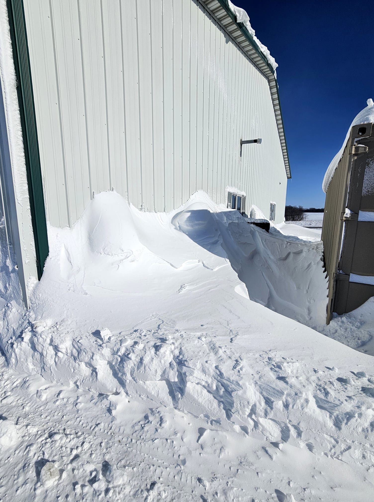
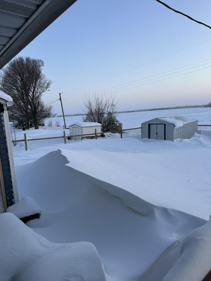
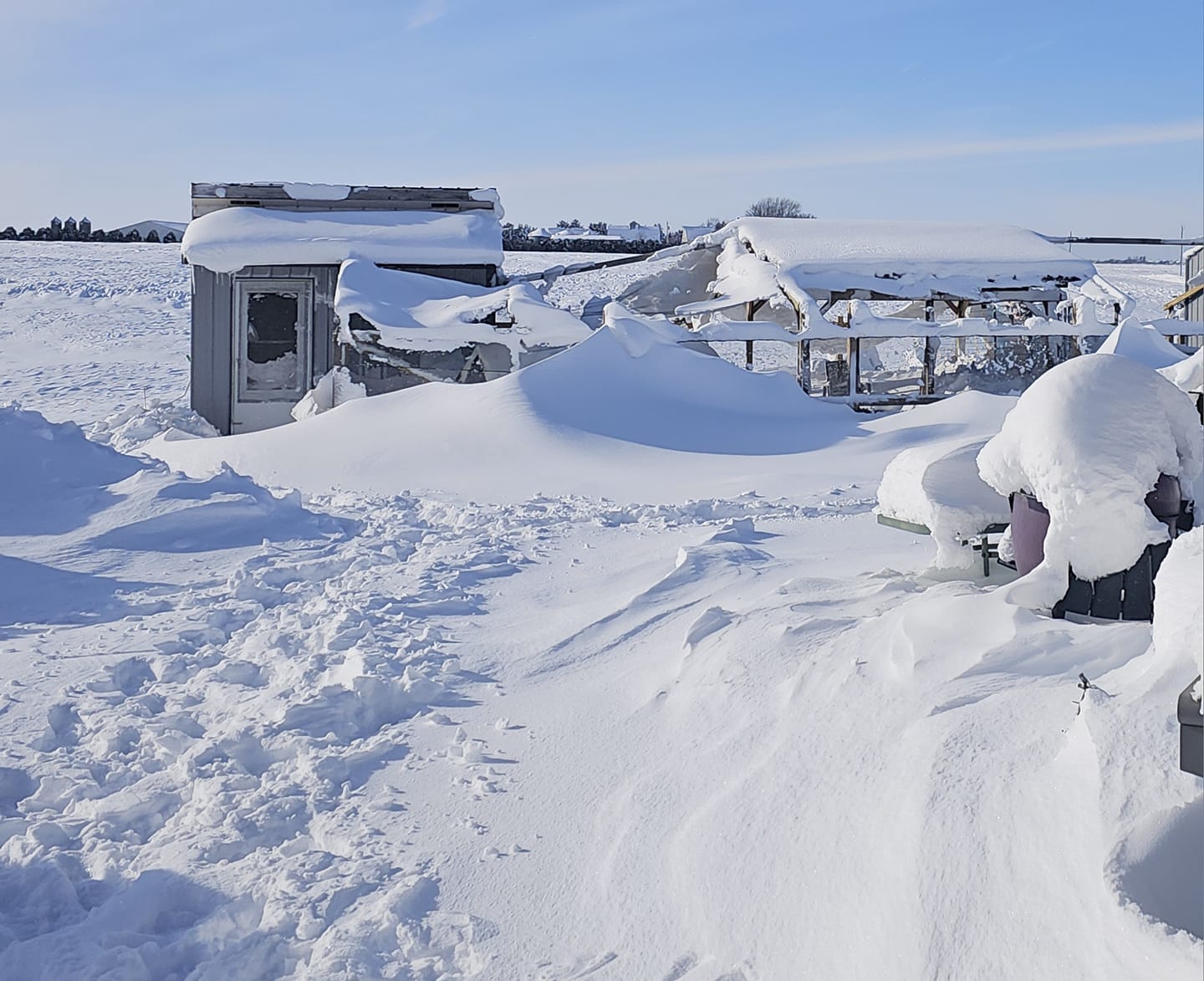
Photos
 |
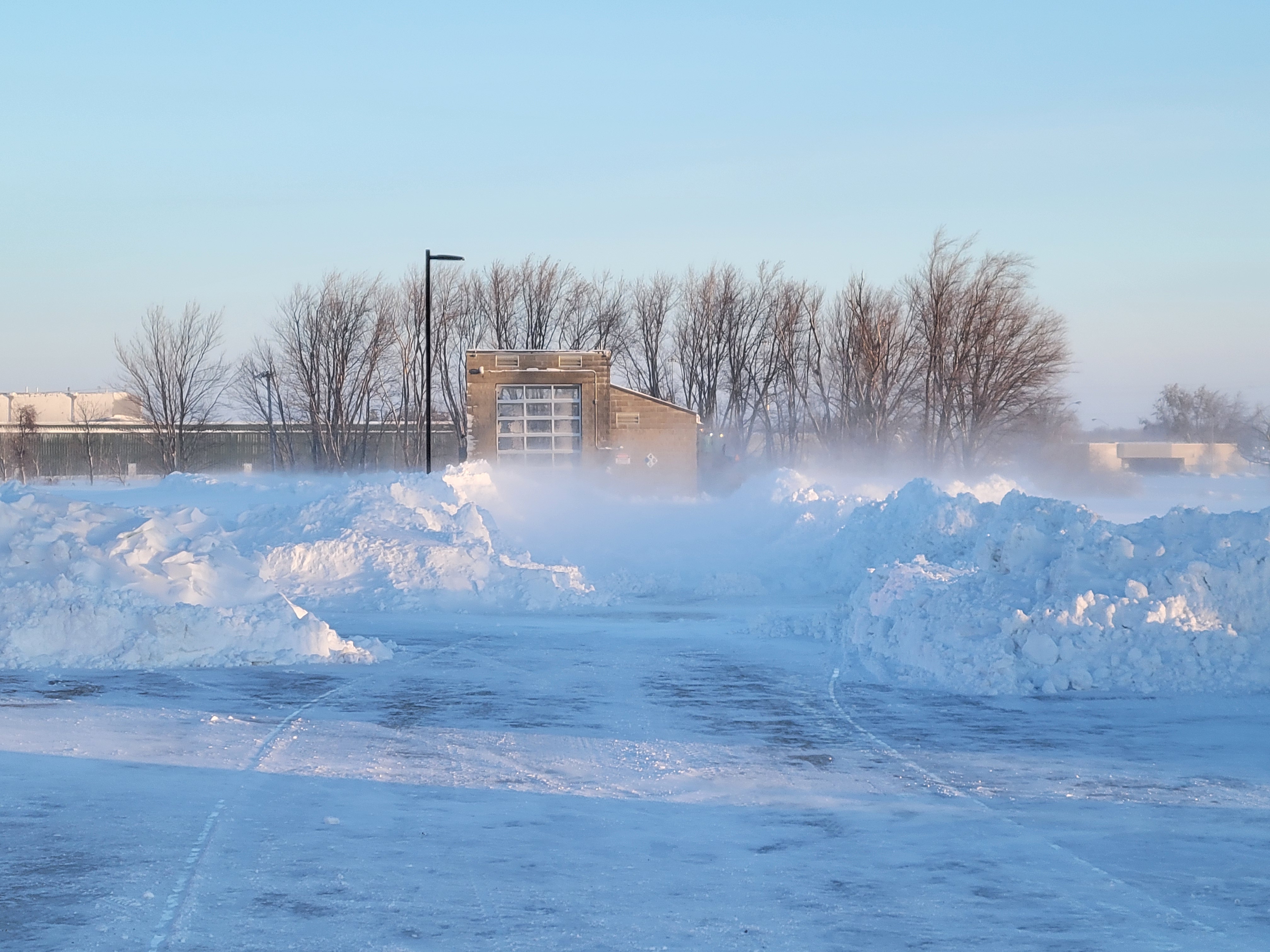 |
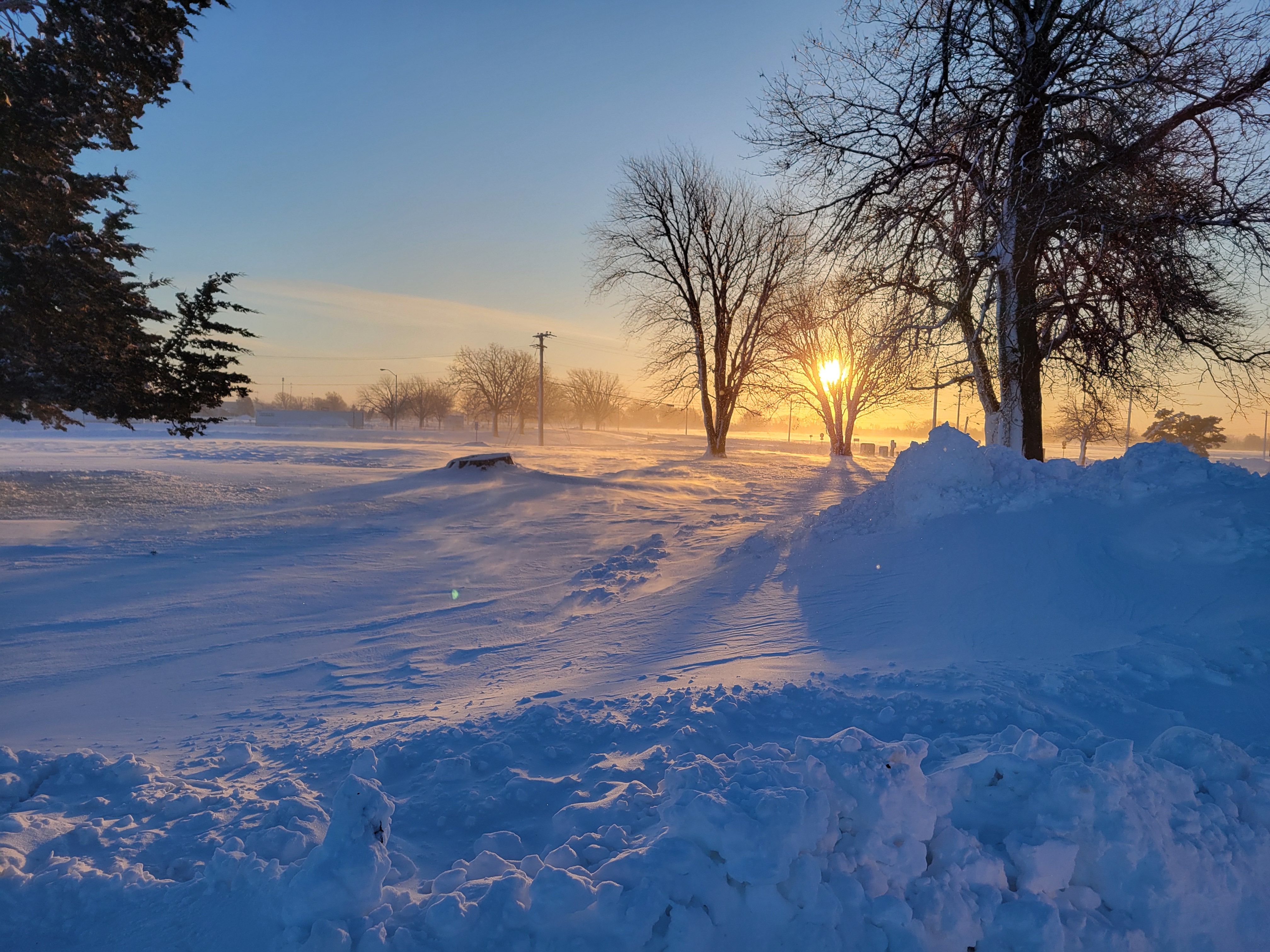 |
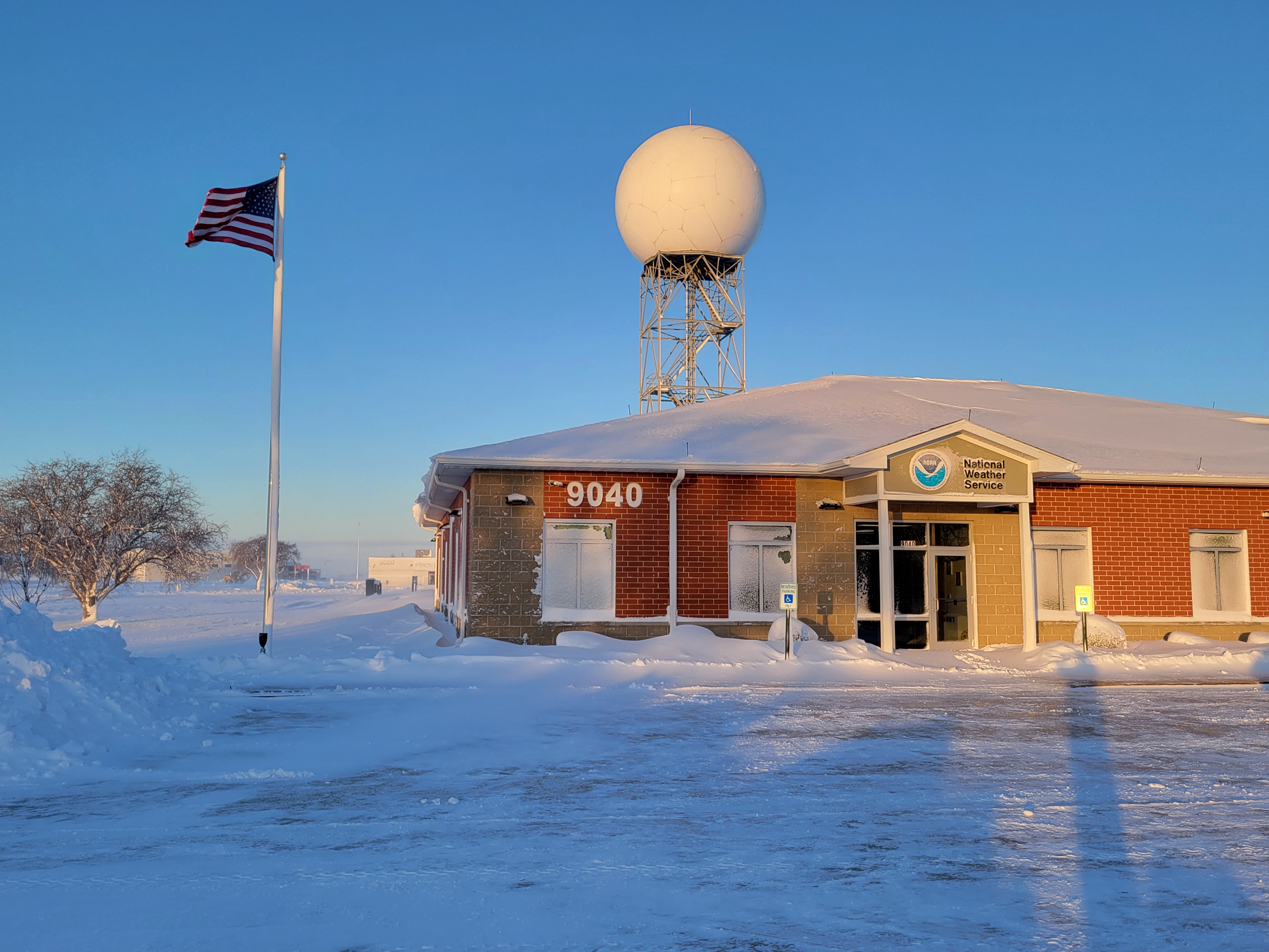
| NWS Quad Cities (Davenport, IA) |
NWS Quad Cities (Davenport, IA) |
NWS Quad Cities (Davenport, IA) |
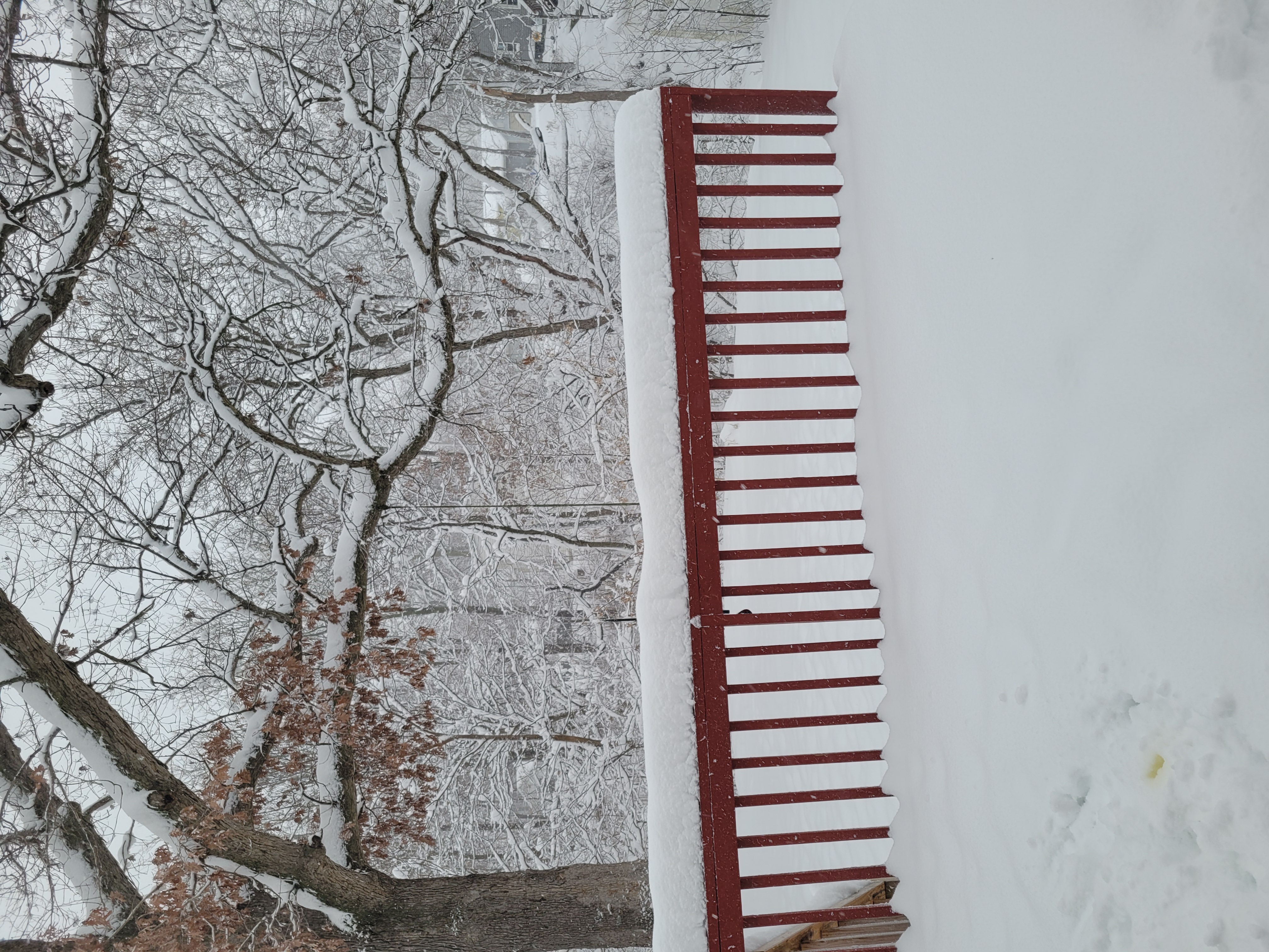 |
 |
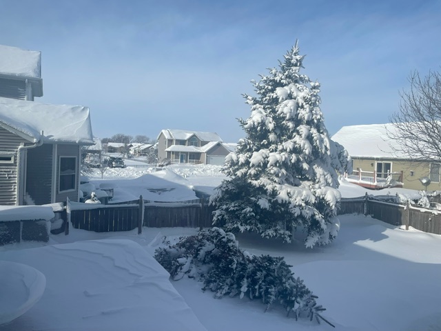 |
| Moline, IL (Tim Gross) |
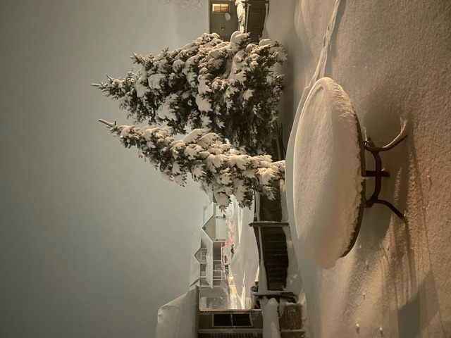
Eldridge, IA | Eldridge, IA Tree Uprooted |
 |
 |
 |
| Dubuque, IA (Eathan Ralston) |
Alpha, IL in Henry County |
Osco, IL in Henry County (Heather Page) |
Maximum Winds
Public Information Statement
National Weather Service Quad Cities IA IL
840 AM CST Sun Jan 14 2024

...HIGHEST OBSERVED WIND GUSTS FROM JANUARY 12-13...

Data is from the winter storm and the time following it when
strong cold air advected into the region. Observations are
collected from a variety of sources with varying equipment
and exposures. Not all data listed are considered official.

Location                     Speed     Time/Date       Provider
---------------------------------------------------------------
Cedar Rapids Arpt            51 MPH    0622 PM 01/13   ASOS
Davenport Arpt               46 MPH    0327 AM 01/13   ASOS
Independence Arpt            45 MPH    0615 PM 01/12   AWOS
Burlington Arpt              43 MPH    1254 AM 01/13   ASOS
Quad City Intl Arpt          43 MPH    0254 PM 01/13   ASOS
Clinton Arpt                 41 MPH    1133 PM 01/13   AWOS
Dubuque Arpt                 41 MPH    1019 PM 01/12   ASOS
Iowa City Arpt               41 MPH    0711 PM 01/12   ASOS
Macomb Arpt                  41 MPH    0515 AM 01/13   AWOS
Muscatine Arpt               39 MPH    0115 AM 01/13   AWOS
Fairfield Arpt               39 MPH    0635 PM 01/12   AWOS
Sterling/Rock Falls Arpt     38 MPH    1228 AM 01/14   AWOS
Vinton Arpt                  38 MPH    0815 PM 01/12   AWOS
Keokuk Arpt                  35 MPH    1155 PM 01/13   AWOS
Mount Pleasant Arpt          35 MPH    0135 AM 01/13   AWOS
Freeport Arpt                32 MPH    0435 AM 01/13   AWOS
Fort Madison Arpt            32 MPH    0155 AM 01/13   AWOS
Cold
Public Information Statement
National Weather Service Quad Cities IA IL
559 PM CST Tue Jan 16 2024

...LOWEST TEMPERATURE OBSERVATIONS FROM JANUARY 14-15...

Location                     Temp      Time/Date       Provider
---------------------------------------------------------------
Fairfield Arpt               -20 F     0115 AM 01/15   AWOS
Iowa City Arpt               -20 F     1152 PM 01/15   ASOS
Cedar Rapids Arpt            -19 F     1152 PM 01/14   ASOS
Clinton Arpt                 -19 F     1156 PM 01/15   AWOS
Sterling/Rock Falls Arpt     -19 F     1156 PM 01/15   AWOS
Burlington Arpt              -18 F     1153 PM 01/14   ASOS
Fort Madison Arpt            -18 F     0735 AM 01/14   AWOS
Quad City Intl Arpt          -18 F     1152 PM 01/15   ASOS
Mount Pleasant Arpt          -18 F     0255 AM 01/15   AWOS
Dubuque Arpt                 -17 F     1153 PM 01/15   ASOS
Keokuk Arpt                  -17 F     0815 AM 01/14   AWOS
Independence Arpt            -17 F     0555 AM 01/15   AWOS
Muscatine Arpt               -17 F     0255 AM 01/15   AWOS
Macomb Arpt                  -16 F     1155 PM 01/14   AWOS
Davenport Arpt               -15 F     1152 PM 01/14   ASOS
Freeport Arpt                -14 F     0815 AM 01/15   AWOS

Observations are collected from a variety of sources with varying
equipment and exposures. We thank all volunteer weather observers
for their dedication. Not all data listed are considered official.
Public Information Statement
National Weather Service Quad Cities IA IL
232 PM CST Sun Jan 14 2024

...MINIMUM WIND CHILL REPORTS...

Location                     WC Temp.  Time/Date       Provider
---------------------------------------------------------------
Cedar Rapids Arpt            -46 F     0452 AM 01/14   ASOS
Clinton Arpt                 -45 F     0826 AM 01/14   AWOS
Independence Arpt            -44 F     0355 AM 01/14   AWOS
Keokuk Arpt                  -43 F     0635 AM 01/14   AWOS
Macomb Arpt                  -43 F     0635 AM 01/14   AWOS
Sterling/Rock Falls Arpt     -43 F     0656 AM 01/14   AWOS
Fairfield Arpt               -42 F     0935 AM 01/14   AWOS
Quad City Intl Arpt          -42 F     0752 AM 01/14   ASOS
Burlington Arpt              -41 F     0553 AM 01/14   ASOS
Davenport Arpt               -41 F     0252 AM 01/14   ASOS
Dubuque Arpt                 -40 F     0853 AM 01/14   ASOS
Iowa City Arpt               -40 F     0752 AM 01/14   ASOS
Mount Pleasant Arpt          -40 F     0715 AM 01/14   AWOS
Fort Madison Arpt            -39 F     0855 AM 01/14   AWOS
Muscatine Arpt               -39 F     0715 AM 01/14   AWOS
Freeport Arpt                -35 F     0635 AM 01/14   AWOS

Observations are collected from a variety of sources with varying
equipment and exposures. We thank all volunteer weather observers
for their dedication. Not all data listed are considered official.
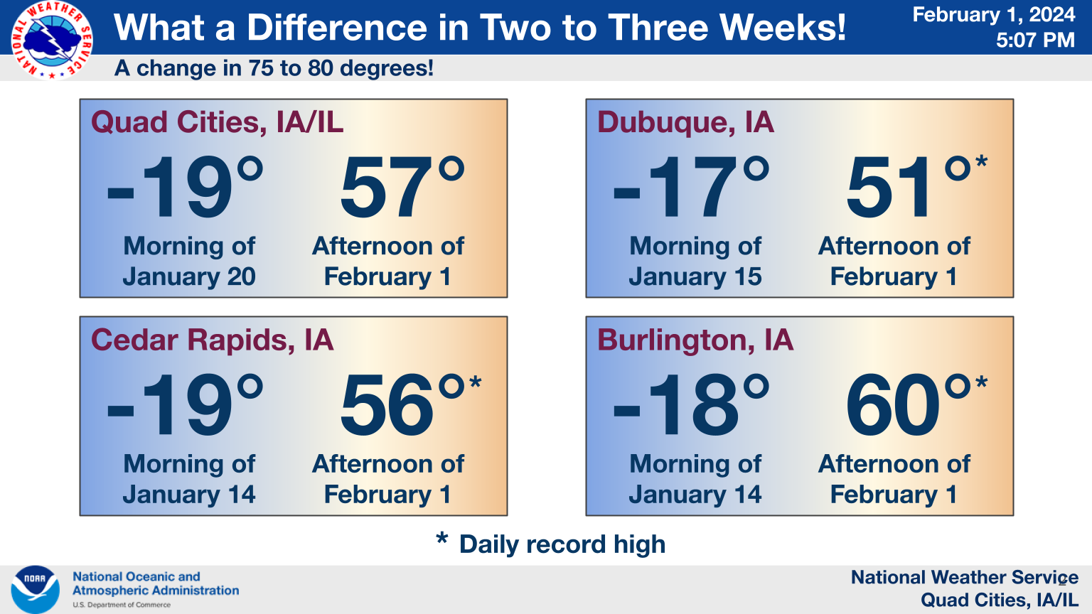 |
| After the significant cold snap, temperatures bounced back relatively quickly, especially considering how much snow was initially on the ground. |
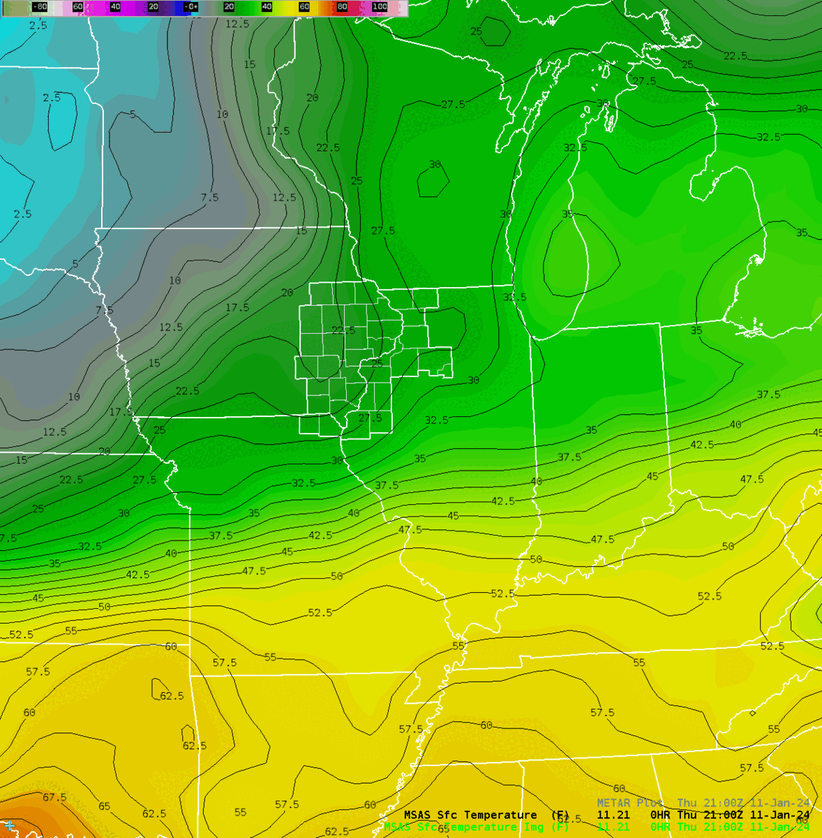
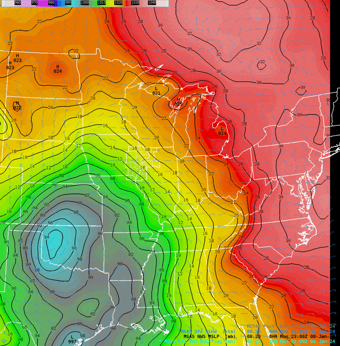
Environment
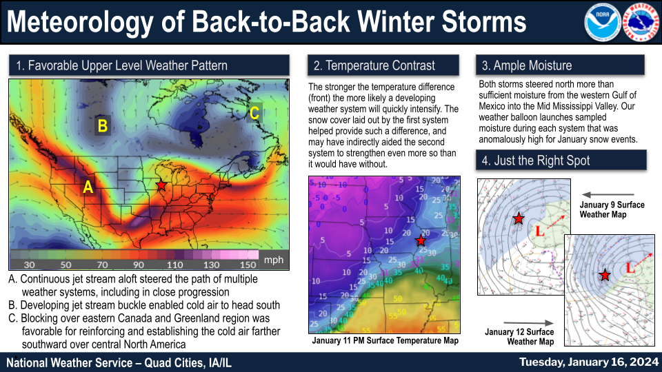 |
| Meteorology of the January 9 and January 12 winter storms within One Week |
 |
 |
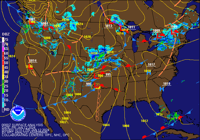 |
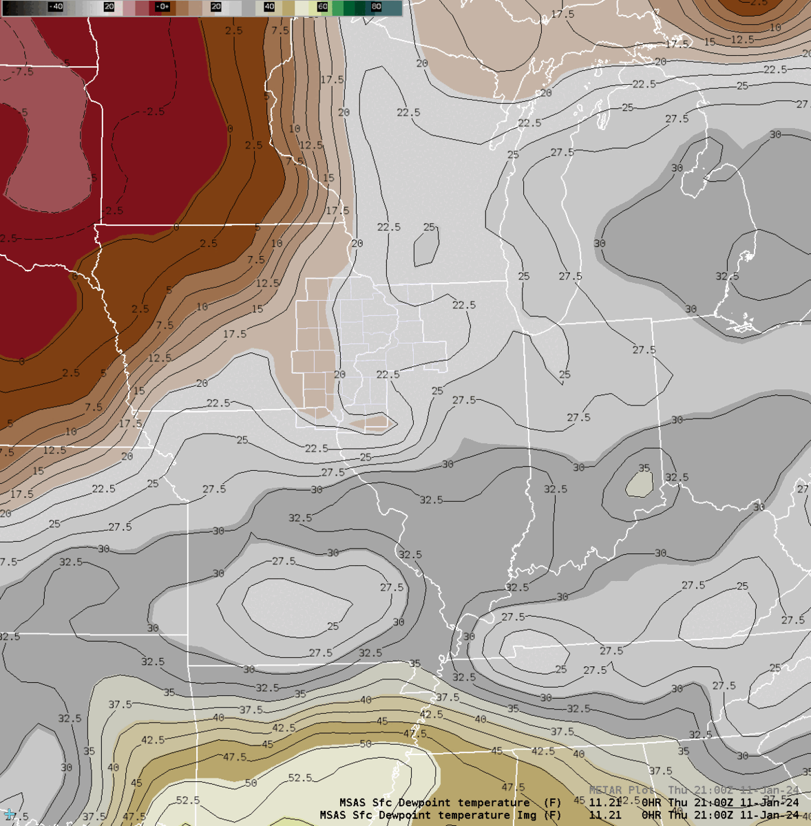
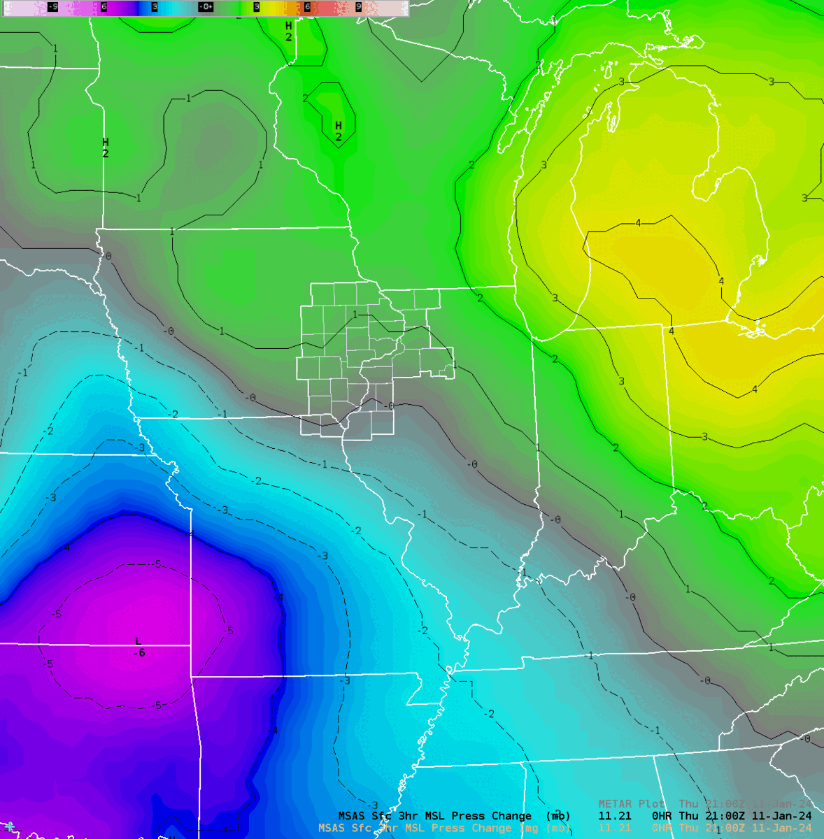
| Figure 1: Temperature Loop from MSAS | Figure 2: MSLP from MSAS analysis | Figure 3: WPC Sea Level Pressure/Fronts/Radar Loop |
 |
 |
|
| Figure 4: Dew Point from MSAS | Figure 5: MSAS 3-hr Pressure Change |
 |
Media use of NWS Web News Stories is encouraged! Please visit our Events Page for a catalog of more events. |
|