A significant heat wave continues for the Rockies, Northern Plains, and Great Lakes into the Mid-Atlantic, peaking in intensity through midweek and lingering across parts of the Northern Plains and Midwest until this weekend. Excessive rainfall my bring life-threatening and locally catastrophic flash and urban flooding across portions of southwestern Texas through early Friday. Read More >
Brief Summary:
(see tabs below for much more, including full narrative and graphics!)
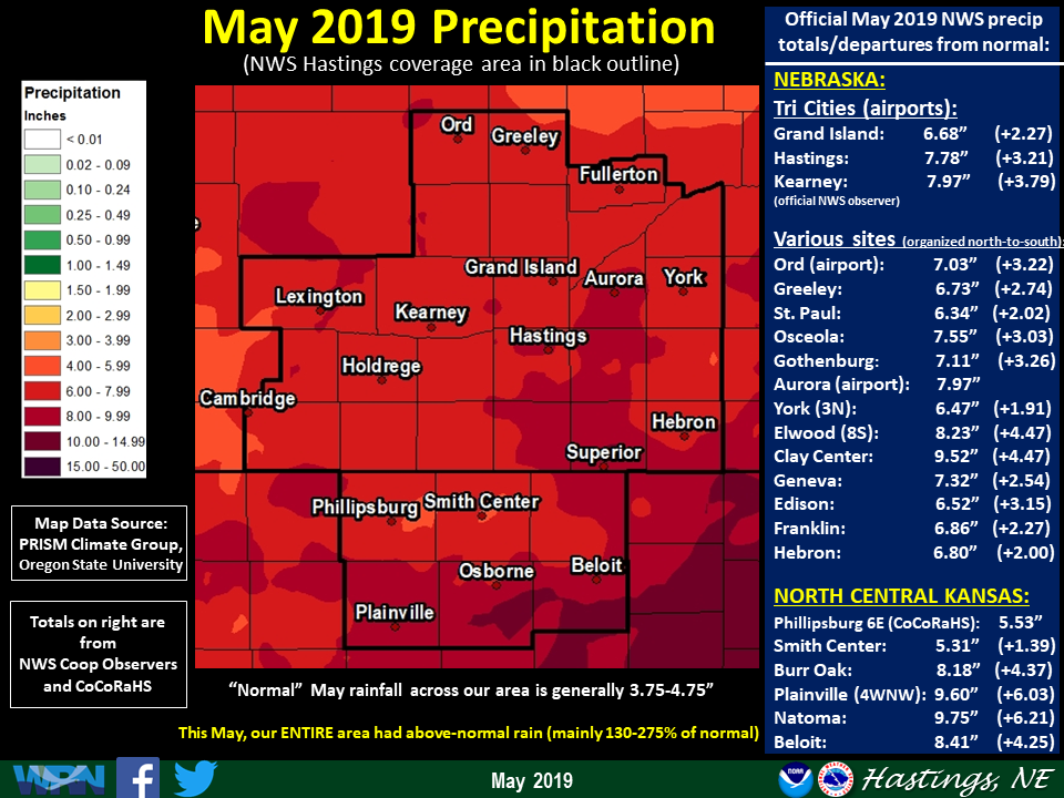
May 2019 will be remembered for being a wet and cool month. Rainfall-wise, the ENTIRE area received solidly above-normal amounts (most areas between 130-220% of normal), with the last part of the month also featuring fairly widespread flooding. Temperature-wise, most places averaged 3-5º cooler than normal. There were eight confirmed tornadoes during the month, several of which caused at least minor damage, but fortunately no injuries (See full narrative in tabs below for much more detail!)
NOTE: All information in this story pertains to the 30-county NWS Hastings Coverage Area
2018 Nebraska Cooperative Observer Precipitation Tables (around 45 sites) |
Narrative
- Rainfall: You know when one of the driest spots in the entire coverage area was still more than 1" above normal, that you're talking about a pretty wet month! Indeed, that was the case during May 2019 as literally the ENTIRE 30-county area was wetter-than-normal, with the majority of places somewhere between 130-220% of normal. Several official NWS stations had a Top-10 wettest May (including 4th-wettest at Hastings airport and 8th-wettest at Kearney airport). Although carrying shorter periods-of-record, a few places even notched their outright-wettest May on record, including Natoma KS (wettest out of 86 with 9.75") and Clay Center (wettest out of 48 with 9.52"). For most locations, the overall-wettest period of the month focused between the 18th-28th, and particulary the 26th-28th. This resulted in fairly extensive (albeit mostly minor) flooding...see separate "Flooding" section below for more on this. Per dozens of NWS/CoCoRaHS observers, a few of the highest-known May totals were quite impressive, featuring: 11.23" east of Hunter KS, 11.20" southeast of Roseland, 11.06" near Fairfield, and 11.02" near Blue Hill and also northeast of Superior. On the "drier" side (but still solidly above normal!) included: 5.22" at Carleton, 5.31" in Smith Center KS, 5.38" at Wilsonville, and 5.53" six miles east of Phillipsburg KS
Focusing on short-term/24-hour-or-less rain totals: many of the highest from NWS and CoCoRaHS/NeRAIN observers were reported during the 24-hour period ending the morning of the 27th, featuring: 4.89" at Polk, 4.17" seven miles west of Osceola, 4.05" near Stamford and 3.96" south-southeast of Roseland.
- Flooding: Going hand-in-hand with the well-above normal rainfall discussed above, flooding became an issue within many counties during the last several days of the month, as most areas received at least 3-6" of rain between the 21st-28th. Fortunately, most of this flooding was of the fairly low-impact variety (and not as serious as what occurred just a few months ago in March), but a number of creeks and rivers breached at least minor flood stage, not to mention the flooding of countless low-lying areas and rural roads. Of the various rounds of heavy rain that occurred in late-May, the most significant one focused between the afternoon of the 26th and the early AM of the 27th. During this 24-hour period, roughly two-thirds of the 30-county area received at least 2-4", particularly within Nebraska counties and also the northwestern half of Phillips County KS. Then, the very next night (the 27th into early AM of the 28th), some of these same areas (particularly in Nebraska) received another 1-2", only worsening or prolonging flooding issues. Although specific instances of flooding during late-May 2019 are too numerous to mention in this narrative, following are some of the more notable highlights (also, see this story for a few flooding photos):
- Flash Flooding (fairly rapid/serious rapid rises along creeks/rural roads): Officially, no Flash Flood Warnings were issued by NWS Hastings. However, based on ground-truth reports, at least "some" flash flooding likely occurred on the evening of the 26th-morning of the 27th in and near Harlan County, where 3-5" fell in a short time. The emergency manager noted that several county roads washed out, including some that hadn't in decades.
- River Flood Warnings (gauge points and areal Warnings for non-forecast points): Several area rivers/creeks went into at least minor flood late in the month, including (but not limited to): South Fork Solomon River (including the Osborne gauge several times), North Fork Solomon River (including the Glade gauge), Republican River (including gauge points at Guide Rock/Hardy), Little Blue River (including gauge points at Deweese/Hebron), Big Blue River in northern Hamilton/Polk counties and Davis Creek in Polk County (Davis Creek washed over Highway 92/81 near Osceola), West Fork Big Blue River through southern Hamilton/York and northern Fillmore counties (water over several roads), School Creek in northeastern Clay County (Highway 6 briefly closed near Saronville), Thompson Creek at Riverton, Prairie Dog Creek in northern Phillips/southern Harlan counties, Buffalo and Spring Creeks in southeastern Dawson County, Clear Creek in northern Polk County.
Of particular note due to its unusual/rare nature:
- The South Fork Solomon River actually breached minor flood at the Osborne gauge FOUR TIMES between the morning of the 22nd and the evening of the 27th, finally falling below flood for good on the morning of the 31st.
- The gauge along the Prairie Dog Creek near Woodruff KS crested around 22 ft. on the 27th, unofficially the 6th-highest crest in its history, and the highest since 1977!
- Extensive flooding occurred in the Overton area due to flooding along the Spring and Buffalo Creeks, including flooding of a truck stop at Interstate 80 exit 248.
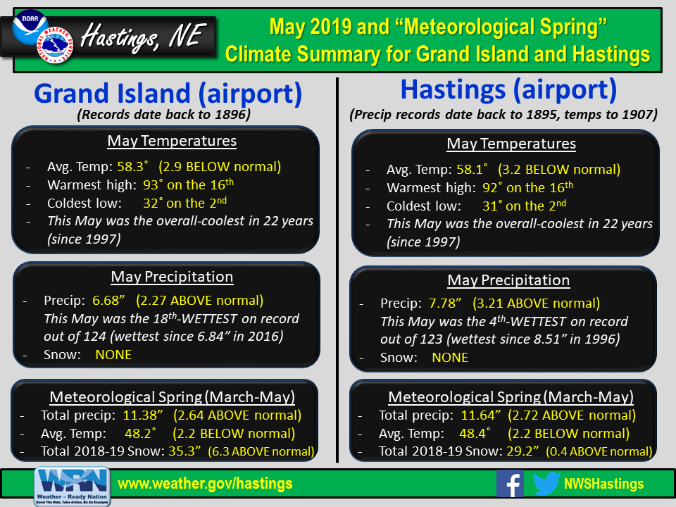
- Temperatures: What a difference a year makes! In sharp contrast to May 2018 (which was a Top 5-to-10 warmest for many), this May was markedly-cooler, with most places averaging a solid 3-5º below normal. As would typically be expected, the overall-coolest week of the month occurred during the first half, between the 6th-12th. During that week, places such as Grand Island, Hastings and Ord failed to reach 60º on four days. In addition, the 10th featured the last widespread freeze of the season within the area, as several primarily northern/western counties dropped into the 28-32º range. Immediately following this notably-cool stretch, the overall-warmest week of the month arrived between the 12th-18th, highlighted by the 16th when the entire area soared into the low-mid 90s. Following the mid-month warmth, a relatively cool stretch resumed to round out the month. In fact, places such as Hastings and Ord went 13-consecutive days (18th-30th) without reaching 80º. Also of note, the 20th-21st were two particularly cool consecutive days, with most places only reaching the mid-40s to low-50s. At Hastings, this was the overall-coldest two-day stretch so late in the spring since 1992!
As for monthly extremes, most all official NWS observers/automated stations recorded their hottest readings on the 16th, including: 95º at Smith Center KS, 94º at Clay Center and 93º at several locations such as Grand Island airport, Hebron airport and Osceola. On the opposite end of the thermometer, the coldest readings of May occurred on the morning of the 10th, featuring: 28º at Ord airport, Ravenna and Greeley, and 29º at Edison and Holdrege.
- Severe Thunderstorms/Tornadoes/Severe Non-Thunderstorm Winds (for official severe storm reports refer to NCEI Storm Events Database):
Even by typically-busy May standards, this was a fairly active month, featuring 8 confirmed tornadoes, including an EF-2 on the afternoon of the 28th in southeastern Osborne/southwestern Mitchell counties (this was the first EF-2 or stronger tornado within the NWS Hastings area in 3-4 years). The majority of severe storms and tornadoes concentrated on five particular days: the 5th, 17th, 26th-28th. Briefly touching on each of these...
- May 5: Severe storms produced mainly large hail within several Nebraska counties, but particularly Hamilton/Adams/Clay. A large supercell storm that dropped almost due-south through Hamilton County yielded a few reports of tennis ball to baseball size hail.
- May 17: A supercell storm tracked northeastward through western and north central Dawson County, producing three tornadoes, including two that narrowly missed the communities of Farnam and Cozad...see this story for more details.
- May 26-28: Severe storms and tornadoes occurred on each of these days, with a cumulative four confirmed tornadoes (including an EF-2 in KS on the 28th), along with several reports of large hail/damaging winds and fairly widespread (albeit mostly minor) flooding...see this story for more details.
- # of confirmed tornadoes during May 2019: 8 (1 rated EF-2 : Osborne/Mitchell counties May 28... 3 rated EF-1: two in Dawson County May 17, one in Franklin County May 26...4 rated EF-0: one in Dawson County May 17, one in Rooks County May 21, one in Nuckolls County May 27, one in Mitchell County May 27)
- Largest known hail stone diameter reported to NWS Hastings: 3" reported three miles east of Codell KS (Rooks County) on the evening of the 28th.
- Strongest known measured thunderstorm wind gust: 69 MPH at few mesonet stations in western Mitchell County KS on the evening of the 17th (unofficial)
- Strongest known measured NON-thunderstorm wind gust: 70 MPH at a mesonet station in rural eastern Rooks County KS on the evening of the 26th (likely associated with a "wake low" pressure event...unofficial)
- Notable wind damage (non-tornadic) reported to NWS Hastings (ground-truth reports): Nothing of particular note, as the vast majority of wind damage reports were associated with confirmed tornadoes.
- # of Severe Thunderstorm Warnings issued by NWS Hastings: 100 (23 more than 2018)
- # of Tornado Warnings issued by NWS Hastings: 17 (4 more than 2018)
Grand Island & Hastings Details (Including 12-Month History):
 |
 |
 |
| Detailed May 2019 info for Grand Island/Hastings (Click to enlarge) |
May 2019 Grand Island Temperature Departures From Normal |
May 2019 Hastings Temperature Departures From Normal |
 |
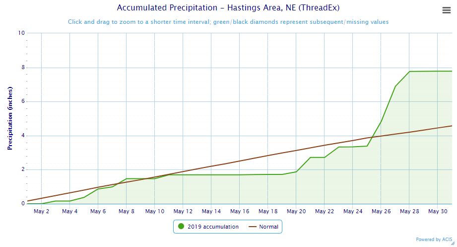 |
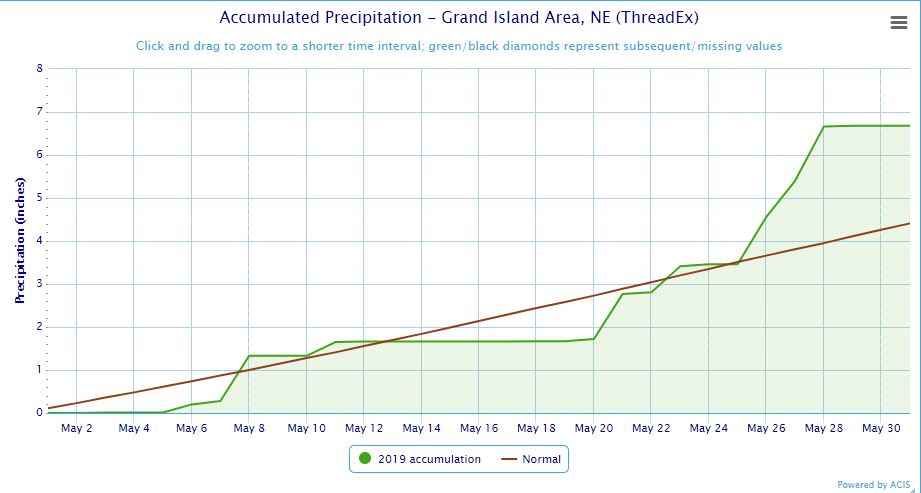
| Grand Island Precipitation Summary: The green line indicates cumulative observed precipitation for May 2019.The brown line indicates "normal" May precipitation based on 30-year data from 1981-2010. (click to enlarge) | Hastings Precipitation Summary: The green line indicates cumulative observed precipitation for May 2019. The brown line indicates "normal" May precipitation based on 30-year data from 1981-2010. (click to enlarge) |
| Grand Island (Regional Airport ASOS) - June 2018 - May 2019 | ||||||||||||
| June | July | Aug. | Sept. | Oct. | Nov. | Dec. | Jan. | Feb. | Mar. | Apr. | May | |
| Average High (F) | 88.2 | 85.8 | 84.3 | 77.4 | 61.3 | 45.9 | 39.5 | 36.4 | 26.8 | 43.8 | 65.7 | 68.9 |
| Average Low (F) | 64.8 | 64.6 | 62.5 | 57.4 | 38.1 | 24.2 | 20.2 | 17.5 | 9.3 | 24.4 | 38.6 | 47.6 |
| Average Temperature (F) | 76.5 | 75.2 | 73.4 | 67.4 | 49.7 | 35.0 | 29.9 | 27.0 | 18.1 | 34.1 | 52.2 | 58.3 |
| Departure From Normal | +5.2 | -1.0 | -0.6 | +2.3 | -2.5 | -3.1 | +3.2 | +1.9 | -11.0 | -5.3 | +1.6 | -2.9 |
| Precipitation (in) | 4.61 | 3.58 | 2.67 | 2.49 | 2.88 | 1.69 | 3.44 | 0.14 | 0.81 | 3.67 | 1.03 | 6.68 |
| Departure From Normal | +0.31 | +0.18 | -0.45 | +0.26 | +1.02 | +0.52 | +2.81 | -0.39 | +0.13 | +1.87 | -1.50 | +2.27 |
| Snowfall (in) | 0.0 | 0.0 | 0.0 | 0.0 | 1.5 | 7.9 | 4.2 | 1.6 | 10.9 | 8.2 | 1.0 | 0.0 |
| Departure From Normal | 0.0 | 0.0 | 0.0 | -0.1 | +0.5 | +4.8 | -0.9 | -4.9 | +4.6 | +2.8 | -0.5 | 0.0 |
| Hastings (Municipal Airport ASOS) - June 2018 - May 2019 | ||||||||||||
| June | July | Aug. | Sept. | Oct. | Nov. | Dec. | Jan. | Feb. | Mar. | Apr. | May | |
| Average High (F) | 87.0 | 85.5 | 83.3 | 76.4 | 60.9 | 46.3 | 39.9 | 37.0 | 27.5 | 43.7 | 65.5 | 68.1 |
| Average Low (F) | 65.0 | 65.1 | 63.1 | 58.2 | 38.7 | 24.9 | 21.9 | 19.4 | 10.8 | 25.5 | 39.6 | 48.1 |
| Average Temperature (F) | 76.0 | 75.3 | 73.2 | 67.3 | 49.8 | 35.6 | 30.9 | 28.2 | 19.2 | 34.6 | 52.5 | 58.1 |
| Departure From Normal | +4.2 | -1.8 | -1.1 | +1.7 | -2.8 | -3.1 | +3.3 | +2.2 | -10.7 | -5.3 | +1.8 | -3.2 |
| Precipitation (in) | 5.91 | 2.19 | 4.40 | 3.69 | 3.04 | 1.52 | 3.13 | 0.07 | 0.68 | 2.65 | 1.21 | 7.78 |
| Departure From Normal | +2.11 | -1.55 | +1.10 | +1.13 | +1.05 | +0.23 | +2.52 | -0.34 | +0.19 | +0.86 | -1.35 | +3.21 |
| Snowfall (in) | 0.0 | 0.0 | 0.0 | 0.0 | 1.1 | 5.5 | 4.3 | 0.9 | 11.6 | 5.3 | 0.5 | 0.0 |
| Departure From Normal | 0.0 | 0.0 | 0.0 | -0.2 | +0.1 | +2.9 | -1.8 | -5.1 | +5.1 | +0.1 | -0.7 | 0.0 |
Kearney - 12 Month Climate History:
All data here is from the official NWS observer at Kearney airport, with 24-hour observations taken around 7 a.m. ** PLEASE NOTE: This official Kearney data often differs slightly from the unofficial data recorded by the automated airport system (KEAR) **
| Kearney Airport (Coop Observer) - June 2018 - May 2019 | ||||||||||||
| June | July | Aug. | Sept. | Oct. | Nov. | Dec. | Jan. | Feb. | Mar. | Apr. | May | |
| Average High (F) | 86.6 | 84.6 | 82.3 | 77.6 | 59.0 | 45.2 | 37.5 | 34.7 | 27.0 | 41.8 | 64.4 | 65.3 |
| Average Low (F) | 62.9 | 63.0 | 59.9 | 55.8 | 35.7 | 22.6 | 18.4 | 17.1 | 7.0 | 22.2 | 36.1 | 44.5 |
| Average Temperature (F) | 74.7 | 73.8 | 71.1 | 66.7 | 47.3 | 33.9 | 28.0 | 25.9 | 17.0 | 32.0 | 50.3 | 54.9 |
| Departure From Normal | +4.9 | -0.9 | -1.5 | +3.2 | -3.6 | -3.1 | +2.1 | +1.3 | -11.1 | -5.7 | +1.6 | -4.6 |
| Precipitation (in) | 2.87 | 6.07 | 2.05 | 1.85 | 3.50 | 0.85 | 3.49 | 0.23 | 1.06 | 4.78 | 1.80 | 7.97 |
| Departure From Normal (in) | -1.06 | +2.79 | -1.03 | -0.22 | +1.46 | -0.17 | +2.92 | -0.26 | +0.51 | +2.99 | -0.43 | +3.79 |
| Snowfall (in) | 0.0 | 0.0 | 0.0 | 0.0 | 1.4 | 5.7 | 8.7 | 1.5 | 12.9 | 8.6 | 3.1 | 0.0 |
| Departure From Normal (in) | 0.0 | 0.0 | 0.0 | -0.2 | +0.7 | +2.6 | +5.2 | -2.9 | +7.8 | +4.0 | +1.3 | 0.0 |
Ord - 12 Month Climate History:
All snowfall data is from the NWS Cooperative Observer in town. In addition, winter precipitation totals often include Cooperative Observer data given that the automated airport equipment is not designed to accurately melt snowfall liquid equivalent (in most cases).
| Ord (Evelyn Sharp Field ASOS) - June 2018 - May 2019 | ||||||||||||
| June | July | Aug. | Sept. | Oct. | Nov. | Dec. | Jan. | Feb. | Mar. | Apr. | May | |
| Average High (F) | 84.0 | 84.0 | 82.2 | 75.4 | 59.5 | 45.3 | 38.6 | 36.5 | 26.3 | 42.7 | 62.8 | 66.5 |
| Average Low (F) | 60.8 | 62.0 | 59.1 | 54.5 | 33.6 | 20.2 | 14.5 | 15.9 | 6.7 | 22.0 | 34.8 | 43.5 |
| Average Temperature (F) | 72.4 | 73.0 | 70.6 | 65.0 | 46.5 | 32.8 | 26.6 | 26.2 | 16.5 | 32.3 | 48.8 | 55.0 |
| Departure From Normal | +3.2 | -1.4 | -2.4 | +1.4 | -3.1 | -3.5 | +1.7 | +1.6 | -11.3 | -5.4 | 0.0 | -4.3 |
| Precipitation (in) | 7.57 | 5.84 | 2.57 | 1.53 | 2.47 | 0.91 | 3.09 | 0.12 | 1.05 | 4.15 | 2.87 | 7.03 |
| Departure From Normal (in) | +3.45 | +2.87 | -0.59 | -0.91 | +0.54 | -0.16 | +2.50 | -0.25 | +0.61 | +2.70 | +0.28 | +3.22 |
| Snowfall (in) | 0.0 | 0.0 | 0.0 | 0.0 | 0.3 | 3.8 | 10.5 | 2.4 | 15.8 | 13.6 | 6.0 | 0.0 |
| Departure From Normal (in) | 0.0 | 0.0 | 0.0 | 0.0 | -0.8 | -1.5 | +3.1 | -4.4 | +9.8 | +7.7 | +3.5 | 0.0 |
Smith Center, KS - 12 Month Climate History:
All data is from the official NWS observer, with 24-hour observations taken around 7 a.m. As a result, data may vary slightly from true "Calendar Day".
| Smith Center KS (NWS Coop Observer) - June 2018 - May 2019 | ||||||||||||
| June | July | Aug. | Sept. | Oct. | Nov. | Dec. | Jan. | Feb. | Mar. | Apr. | May | |
| Average High (F) | 92.2 | 90.7 | 86.9 | 80.9 | 62.5 | 48.6 | 41.1 | 37.4 | 32.4 | 47.0 | 69.5 | 70.5 |
| Average Low (F) | 63.9 | 65.5 | 62.5 | 57.6 | 38.5 | 24.4 | 20.3 | 18.8 | 11.8 | 24.1 | 37.9 | 46.9 |
| Average Temperature (F) | 78.0 | 78.1 | 74.7 | 69.3 | 50.5 | 36.5 | 30.7 | 28.1 | 22.1 | 35.6 | 53.7 | 58.7 |
| Departure From Normal | +4.0 | -1.6 | -2.5 | +1.1 | -4.3 | -3.9 | +1.9 | +0.4 | -9.9 | -6.0 | +1.2 | -5.0 |
| Precipitation (in) | 6.33 | 3.98 | 3.25 | 3.88 | 4.61 | 0.62 | 3.61 | 0.42 | 0.86 | 1.57 | 0.09 | 5.31 |
| Departure From Normal (in) | +2.72 | +0.11 | -0.05 | +1.84 | +2.73 | -0.60 | +2.95 | -0.07 | +0.28 | -0.30 | -2.18 | +1.39 |
| Snowfall (in) | 0.0 | 0.0 | 0.0 | 0.0 | 1.2 | 5.8 | 2.4 | 7.0 | 12.4 | 7.0 | 1.0 | 0.0 |
| Departure From Normal (in) | 0.0 | 0.0 | 0.0 | -0.2 | +0.8 | +4.0 | -0.8 | +3.3 | +8.3 | +4.4 | +0.4 | 0.0 |
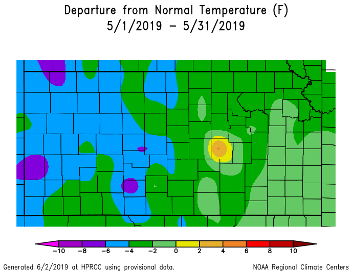
Temperature & Precipitation Departure From Normal Maps:
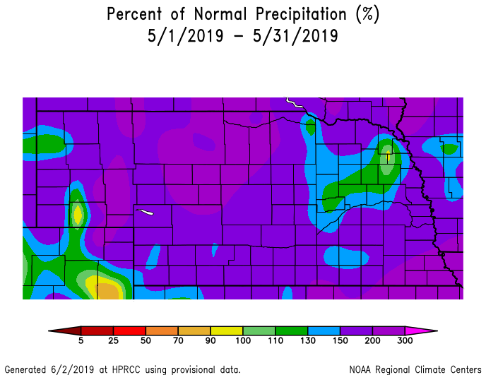
These images depict May 2019 monthly temperature departure from normal & precipitation percent-of-normal for both Nebraska & Kansas. Images are courtesy of the High Plains Regional Climate Center (HPRCC). Please note: These maps occasionally contain "bullseyes" of errant data. For precipitation, you can also generate departure from normal/percent-of-normal maps using the NWS AHPS page, or view local-area images generated each day by NWS Hastings.
 |
 |
 |
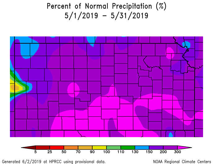 |
| Departure from Normal Temperature - NE (left) & KS (right) | Percent of Normal Precipitation - NE (left) & KS (right) | ||
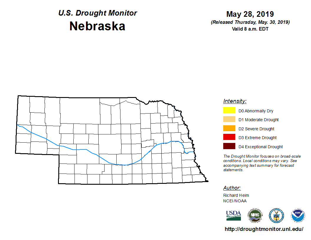
Drought:
The following drought images, current as of May 28, 2019, are courtesy of the U.S. Drought Monitor
Summary of changes during May 2019 across the NWS Hastings coverage area:
Given the well-above-normal rainfall during May across the entire area, the ENTIRE NWS Hastings coverage area remained void of all drought categories during May 2019.
 |
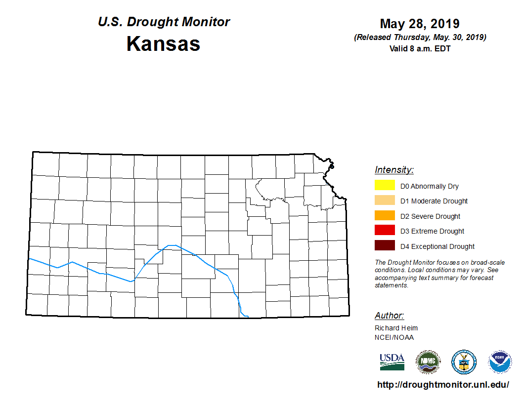 |
| Drought Monitor for Nebraska (left) & Kansas (right). Valid as of May 28, 2019 (click to enlarge) | |
May 2019 Extremes for the NWS Hastings Coverage Area:
...SOME OF THE WARMEST HIGH TEMPERATURES DURING MAY 2019...
(all data from NWS cooperative observers or automated airport sites, with the date it actually occurred indicated in parentheses)
98 degrees...Webster Dam KS (16th)
95 degrees...Smith Center KS (16th)
94 degrees...Clay Center (16th) - Red Cloud (16th)
93 degrees...Cambridge (16th) - Plainville KS 4WNW (16th) - Grand Island airport (16th) - Geneva (16th) - Hebron airport (16th) - Osceola (16th) - York airport (16th) - Kirwin Dam KS
...SOME OF THE COLDEST LOW TEMPERATURES DURING MAY 2019...
(all data from NWS cooperative observers or automated airport sites, with the date it actually occurred indicated in parentheses)
28 degrees...Ravenna (10th) - Greeley (10th) - Ord airport (10th)
29 degrees...Edison (10th) - Holdrege (10th) - Cambridge (10th) - Beaver City - (10th) - Kirwin Dam KS (10th) - Red Cloud (10th)
30 degrees...Oxford 6NNW (10th) - Minden (10th) - Genoa 2W (10th) - Gothenburg (10th) - Hastings NWS office (2nd)
...SOME OF THE HIGHEST MONTHLY RAINFALL TOTALS DURING MAY 2019...
(all data from NWS cooperative observers and CoCoRaHS/NeRAIN observers unless indicated)
11.23"...Hunter KS (9E)
11.20"...Roseland (4SSE)
11.06"...Fairfield (2S)
11.02"...Blue Hill (2NE) - Superior (6NE)
10.76"...Harvard
10.59"...Blue Hill (6ENE)
10.31"...Beloit KS (10SSW)
9.94"...Clay Center (5S)
9.75"...Natoma KS
9.65"...Polk
9.60"...Plainville KS (4WNW)
9.52"...Clay Center
...SOME OF THE LOWEST MONTHLY RAINFALL TOTALS DURING MAY 2019...
(all data from NWS cooperative observers and CoCoRaHS/NeRAIN observers unless indicated)
5.22"...Carleton
5.31"...Smith Center KS
5.38"...Wilsonville
5.53"...Phillipsburg KS (6E)
5.68"...Belgrade
5.71"...Oxford (6NNW)
5.72"...Lebanon KS (7NW)
5.95"...Cozad (4S)
6.06"...Red Cloud
6.29"...Palmer (2W)
 |
Media use of NWS Web News Stories is encouraged! Please acknowledge the NWS as the source of any news information accessed from this site. |
|