
Weather Events of the Decade
2000-2009
 With the end of 2009 comes an end to the first decade of the century and an end to a very interesting period of weather across northern Indiana, southwest lower Michigan, and Northwest Ohio. We want to take time to reflect on these past 10 years and remember the important weather events that affected all of us at times and changed the lives of some forever. Our area saw wild weather ranging from devastating killer tornadoes to crippling winter storms, phenomenal flooding, destructive winds and hail, and incredible lake effect snowfall. There were also periods of great weather as well, There were beautiful winter days with scenic hoar frost on trees, glittering ice creating natural winter wonderlands after damaging ice storms, and peaceful blankets of snow on the ground with crystal clear mornings. There were summers with picture perfect days of bright sunshine, low humidity and comfortable temperatures. For those who like summer heat there were many days with hot temperatures and sauna like conditions. There were mild winters with little snow and unseasonable warmth. But it really is the extreme weather events that had large impacts that we all really remember.
The staff at NWS Northern Indiana has looked back at the weather events over this past decade, 2000 to 2009, and identified 25 of the 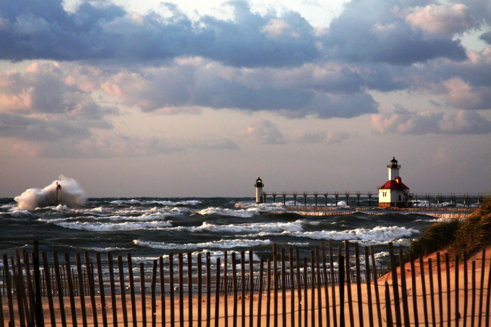 most important weather events that had large impacts within our County Warning and Forecast Area (CWFA). Input from current as well as former staff members who worked here during the decade were collected based on their recollections of high impact events. Several staff members of the Northern Indiana office then ranked these events independently based on their own criteria for importance and significance. The individual rankings were assigned points and a final ranking score was tabulated.
Below is our listing of the most significant weather events of the 2000 to 2009 decade. The 15 most significant are listed first, going from the 15th ranked event to the number 1 ranked event as voted on by our staff. Following the number 1 event is the remaining 10 events which received honorable mention. Several of the events below contain a link to our Archived Weather Events Page where you can find additional information, maps and graphics.
We want to emphasize that all weather events are important and impact people on a daily basis. This is simply our way of trying to determine those events which impacted many lives, had great significance in some way, changed lives, or even changed the way we do our important jobs, which is saving lives! Enjoy the following summary of events. If you have any questions or comments, feel free to send them to Sam Lashley at w-iwx.webmaster@noaa.gov .
15 Most Significant Weather Events of the Decade 2000-2009
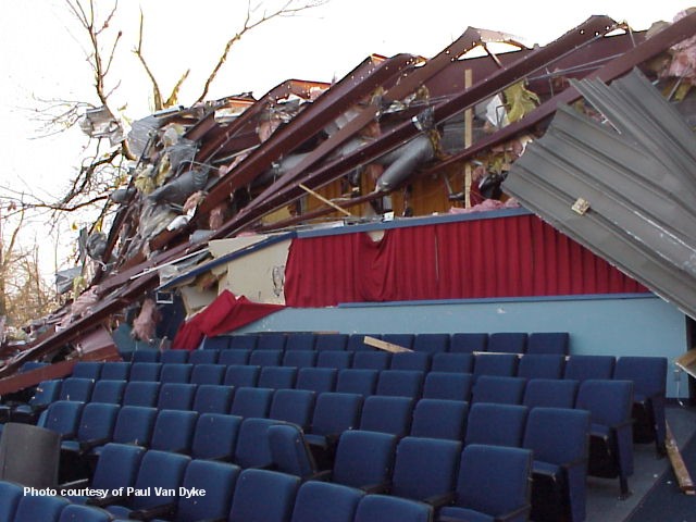
15. Peru Tornado F3 – May 30th, 2004
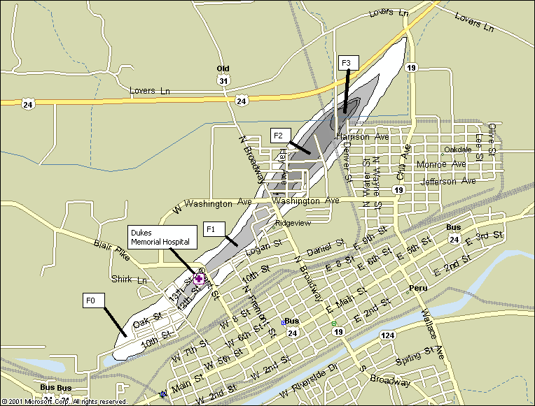 An F3 tornado occurred in Miami County near Peru on Sunday, May 30, 2004. The tornado touched down around 8:55pm. A Tornado Warning had been issued thirteen minutes prior to touchdown, at 8:42pm. The tornado began southwest of Peru and was on the ground for approximately five miles...ending near the intersection of highways 19 and 24. The tornado path was one-eighth to one-fourth of a mile wide. The tornado caused F0 to F1 damage at its onset, then strengthened and caused F2 damage at a trailer park and over the western part of Peru. The tornado then continued to strengthen, causing low-end F3 damage to a large NIPSCO communication tower and tearing the roof off of a factory and knocking down its walls. This damage occurred near the intersection of highways 24 and 19 where the tornado lifted. The tornado had been at F3 strength for about one-third of a mile. Damage also occurred to homes, trees, and other structures.
14. City of Fort Wayne Flash Flood - June 26, 2002
 Phenomenal flash flooding occurred in the city of Fort Wayne and areas of western Allen County as thunderstorms continually redeveloped over central and western parts of the metropolitan area, dropping up to 8 inches of rain (Times Corner) over the course of several hours during the evening. Observers recorded 3.50" of rain in just 90 minutes at the intersection of Taylor and Broadway. Two flash flood warnings were issued for Allen county and the city of Fort Wayne. Numerous cars were stranded in water up to 3 feet deep. Numerous basements were flooded, and most downtown buildings were closed the following day. There was massive damage to buildings in the city from the flooding. There were reports that one building, the Fort Wayne Housing Authority, suffered $750 thousand worth of damage due to the flooding. During the flooding event, there were many rescues of motorists from vehicles stranded by flood water. The Fort Wayne Fire Department assisted 70 disabled vehicles (Fort Wayne Journal Gazette). Most of the heavy rain fell in the Spy Run Creek watershed. The gauge at Spy Run Creek rose to 12.3 feet, its highest stage recorded up to that time (old record was 10.7'). Spy Run Creek rose 9 feet in 8 hours.
Two people were killed and nearly 50 people hurt, including six seriously, when a sudden snow squall swept over Interstate 94 near Benton Center, Michigan, in Berrien County. A narrow and intense snow band associated with a mesoscale low pressure center moved over the interstate and helped cause the large chain reaction accident at 1:30 pm. A total of 60 vehicles were strewn about both carriageways of the busy Chicago-Detroit link for a mile and a half, and closed down a nearly 12-mile stretch of the expressway for over 10 hours. Some vehicles caught fire during the whiteout conditions, and some were so badly damaged that the cars had to be cut apart to extract the occupants. One woman was trapped in her truck for two hours. Snowfall rates were as high as two inches per hour within the band, with total accumulations up to a foot. Winds were around 20 mph. Skies were generally clear or partly cloudy north and south of the narrow snow band. The Northern Indiana office of the National Weather Service issued a Lake Effect Snow Warning for Berrien County at 11:30am, two hours before the crash. This event and several other similar lake effect events are being studied by the NWS Northern Indiana office in hopes of being able to better forecast location, duration, and intensity in the future.
A powerful squall line known as a Derecho brought damaging thunderstorm wind gusts to much of the IWX forecast area. One person was killed when a tree fell on a car at 12:15pm in Coloma, Michigan. Two more people were killed in the same way at 1:00pm in Sturgis, Michigan just three miles north of Colon. Three Rivers experienced 78mph winds at 12:41pm. Hail one inch in diameter was also reported one mile northwest of Fort Wayne, Indiana at 1:45pm and in Decatur, Indiana at 2:27pm.
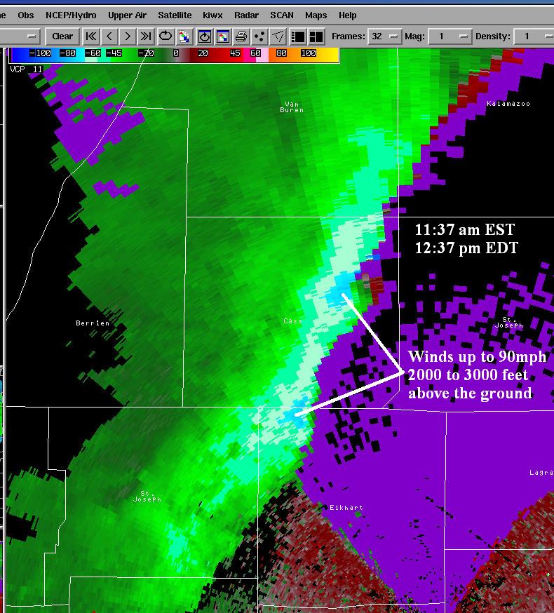
11. Fort Wayne Memorial Weekend Tornado - May 26, 2001
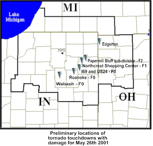 On Saturday May 26th, 2001, a low topped supercell thunderstorm developed in Cass county Indiana, and moved northeast through the Fort Wayne metropolitan area and into northwest Ohio. This thunderstorm produced several tornadoes and numerous funnel clouds. The most damage occurred on the northwest and north side of Fort Wayne, where the damage path indicated an F2 tornado that was 1000 feet wide. An F2 tornado has wind speeds between 113 and 157 mph. The National Weather Service Office in Northern Indiana issued several tornado warnings ahead of this storm. The warning for Allen county and the Fort Wayne metro area was issued 15 minutes prior to the first reported touchdown in southwest Allen county, and 25 minutes before the tornado hit the Northcrest Shopping Center in Fort Wayne at 545 pm EST. Several cars were turned upside down and part of the roof of the shopping complex was torn off. Signs near the shopping center were badly damaged. Several area businesses also sustained wind damage and many vehicles in the parking lots were either overturned or damaged by flying debris. This tornado was classified as an F1 with a path length of one half mile and a width of 500 feet. The tornado lifted briefly but quickly set down again, about a half mile northeast of the mall in the Papermill Bluff sub-division. Numerous homes sustained major damage. Two homes had the roofs completely lifted off, as well as at least two outside walls demolished. The tornado stayed on the ground as it moved into the Papermill Bluff Office Park. Part of an office building was severely damaged while the remainder of the office buildings had broken windows, roof and siding damage. The tornado was rated as an F2 through the subdivision and the office park with major damage. The tornado continued on the ground across St. Joe Center road into another sub-division and the Towne House Retirement home. The roof of the retirement home was partially blown off and numerous trees on the grounds were twisted, broken off and uprooted. Numerous trees in the sub division were also uprooted and torn, and several homes sustained damage. Much of the damage here was F1, but some damage to a few homes indicated brief F2 strength. Several minor injuries were reported with this storm in Allen county, but no major injuries or directly related deaths occurred. Interviews with people in the path of this tornado indicated they had heard warnings for Allen county but did not think the tornado would hit their area.
10. Michigan City Supercell - August 23rd, 2006
 A supercell thunderstorm developed on the afternoon of August 23rd, 2006 along a lake breeze boundary just south of Milwaukee, Wisconsin. The storm moved southeast and then south over Lake Michigan and continued to intensify. As the storm moved onshore in Michigan City, Indiana, a 106 mph wind gust was recorded at the GLERL observation site near the Michigan City lighthouse. The storm produced extensive damage in Michigan City with hundreds of trees and power lines down, some on cars and buildings. A train was blown off the tracks in northern Porter County. Golf ball sized hail, which covered the ground in places, was also reported with this storm. Washington Park in Michigan City was especially hard hit as thunderstorm winds swept in off the lake. The largest in water boat show in the Great Lakes was setting up in the park for a 4 day show when the storm hit. Several boats and trailers were destroyed, and the tents and merchandise were significantly damaged and scattered all over. A few boats were turned upside down in the water while anchored to the piers. The storm continued to produce damage as it moved south through LaPorte County with extensive damage in Westville and the City of LaPorte . As the storm continued south into Starke County, tennis ball sized hail was reported along U.S. Route 30, a few miles west of Hamlet. The storm continued to produce large hail and strong winds as it dropped south through Pulaski and White counties with damage reported in Winamac, Medaryville, and Monticello.
9. Valentine’s Blizzard - February 13th-14th, 2007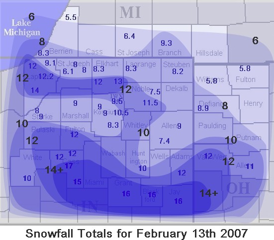
Blizzard conditions and heavy snowfall created impassable roads, large snow drifts and dangerous conditions across most of the IWX CWA. A strong upper level disturbance moved out of the southern plains and helped generate an area of low pressure at the surface in central Texas. The surface low pressure moved northeast across central Kentucky while the upper level disturbance moved across central Indiana. Deep moisture from the Gulf of America was drawn northward ahead of this system which resulted in widespread heavy snow across most of northern Indiana, southwest lower Michigan and Northwest Ohio. At the same time...a very cold arctic high pressure area was settling south across the lower Great Lakes. The pressure gradient between the high and low pressure areas created 20 to 30 mph sustained winds with wind gusts around 45 mph at times. The wind and snow combined to create snow drifts of 4 to 7 feet across the area. Many counties were forced to stop plowing because they could not keep up with the drifting and some trucks were getting stuck themselves. Numerous county roads were closed or nearly impassable. Several NWS employees were unable to drive to work and had to be picked up by others with 4-wheel drive vehicles. The heaviest snow from this system fell across north central Indiana. Snowfall amounts ranged from 12 to 18 inches in the heaviest band which occurred from near Lafayette, Indiana...east to Marion and Portland, Indiana. A secondary heavy snow band also occurred from near Laporte Indiana to Goshen Indiana. 10 to 14 inches were reported in this narrow area.
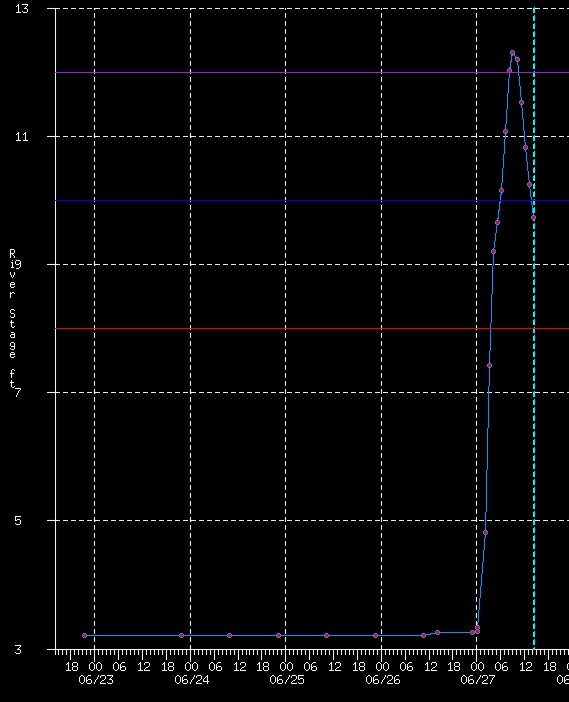
8. Record River Flooding Including Norway Dam - January 8, 2008

January started out with heavy snows across southwestern Lower Michigan and northern Indiana. The New Year’s holiday saw as much as 2 feet of snow fall adjacent to areas of Lake Michigan. The following week, record high temperatures were recorded over the area and then showers and thunderstorms with very heavy rainfall accompanied a cold front that moved across the area. Over 5 inches of rain occurred across parts of northwest Indiana. South Bend reported a record amount of precipitation for the month with 5.34 inches. This value more than doubled the normal amount of 2.27 inches. More than 2 feet of snow was also recorded at South Bend for the month. All of these factors combined to create major to record flooding across Northern Indiana. The northwestern half of the state saw the highest river levels. Three river sites set new record high crests. The Tippecanoe River at Ora crested at 15.63 feet. The old record was 15.22 feet. Bean Creek near Powers observed a record crest of 18.87 feet, topping the record of 18.65 feet. The Pigeon River near Scott crested at 7.32 feet which was above the old record of 6.55 feet. The major river flow along the Tippecanoe River produced a record discharge at the Norway Dam in Monticello Indiana. At its peak, the discharge through the dam was 25,087 CFS and water was near the top of the spillway. This record high discharge resulted in major flooding downstream in the town of Monticello. More than 300 homes were damaged by the flood waters from the Tippecanoe River. This event made national news headlines due to the large scale flooding.
7. Severe Drought to Near Record Flooding - Summer 2007
 After an extended period of very dry weather and weeks of moderate to severe drought...most of northern Indiana...northwest Ohio and southwest lower Michigan experienced very heavy rainfall during the month of August 2007. The months of June and July 2007 were very dry over the entire area, with precipitation deficits of 25 to 50 percent of normal. Moderate drought (D1) was reported across many areas...but eastern Indiana and northwest Ohio reported Severe drought (D2) conditions during July and early August. Many agricultural crops, especially corn, was considered a total loss due to the very dry conditions. Rivers and streams were at critically low levels, as were local ponds and even some lakes. Many areas had imposed watering restrictions.
The month of August brought an extreme and abrupt change in the weather, especially for northwest Ohio. Between August 16th and 22nd...much of northern Indiana...southwest lower Michigan and northwest Ohio received between 4 and 15 inches of rain. Van wert and Putnam counties in northwest Ohio were the hardest hit areas...with the higher amounts of between 8 and 15 inches falling in these counties. This is an astonishing 500 to 600 percent of normal rainfall for this period, which occurred in an area under D2 severe drought conditions. The village of Ottawa Ohio in Putnam county was completely engulfed by flood waters from the Blanchard river. The river crested at 31.7 feet on the 23rd of August...over 8 feet above the flood stage of 23 feet. This was the second highest crest ever at Ottawa, second only to the March 1913 crest of 33.3 feet. Much of the village of Ottawa experienced major flooding and many areas had been evacuated. Flood waters were 4 to 8 feet deep in parts of downtown Ottawa, with first floors of many homes and businesses under water. The drought conditions had made national news headlines due to the loss of corn crops. The flooding of the Blanchard river also made national news with most national network news shows and the Weather Channel doing live reports from areas along the Blanchard.
6. Big Summer Floods - July 2003
Extensive flooding occurred across a large part of northern Indiana and northwest Ohio during what turned out to be the 2nd wettest July on record and the 3rd wettest overall month on record at Fort Wayne. Severe flooding occurred in and around Fort Wayne for nearly two weeks with over 200 private structures, ten businesses, and numerous public facilities damaged in Fort Wayne alone from flooding. The Saint Mary’s River in Decatur reached a record crest of 26.9 feet (flood stage is 17 feet), flooding 200 homes. The Wabash River in Bluffton reached its second highest crest of record, 18.3 feet (flood stage is 10 feet) with widespread flooding along the river. One man was killed near Bluffton along the swollen Wabash River when he was swept off his 4-wheeler and down the river, drowning. Water behind the dam at JE Roush reservoir came within just a few inches of topping the spillway. Damages totaled $16.5 million across Allen, Wells, and Adams counties, with millions more in damages in northwest Ohio. Cass county, IN reported 11.6 inches of rain from July 4th through July 9th.
5. Nappanee Tornado - October 18th, 2007

A single tornado touched down during the late evening hours of October 18th, 2007 and moved through the town of Nappanee, Indiana. Damage associated with this long track tornado began near the intersection of 12B road and Gumwood road...just west of Bourbon around 10:05 pm EDT. Shingle and tree damage was found...consistent with an EF0. As the tornado moved rapidly northeast at over 50 mph, it intensified rapidly, tracking between Bremen and Bourbon. Several structures, trees and power lines suffered varying degrees of damage with the intensity reaching high end EF1 intensity just prior to crossing into Kosciusko county near 1000N along the county line with a path width near 1/2 mile. The tornado continued to intensify over northwest Kosciusko county, reaching EF3 intensity, just south of Nappanee with 17 homes suffering extensive damage. The tornado contracted as it entered into southeast Nappanee, reaching max intensity of a high end EF3 with winds estimated at 165 mph, and caused widespread severe damage to homes and businesses within its quarter mile path width. Over 100 structures suffered significant damage or were destroyed in Nappanee. The tornado continued moving northeast out of town...northeast of Nappanee...but weakened with EF1/EF0 damage observed prior to lifting near the intersection of CR46 and CR17. The tornado path extended for 20 miles with a maximum width of one half mile and a peak intensity of EF3 on the Enhanced Fujita Scale. Despite this tornado moving through the heavily populated area after 10 pm EDT, only minor injuries consisting of bumps, bruises and cuts were reported. This event received national media attention.
4. Severe Ice Storm - January 5th 2005
A severe ice storm devastated portions of northern and central Indiana and northwest Ohio beginning early on the 5th of January and continuing into the 6th. A strong surface low moved north/northeast from Kentucky along a stationary surface front. Moisture advected north by this low combined with arctic air moving in from the northwest to set the stage for a major winter storm. Between 1 and 2 inches of freezing rain occurred. The worst icing and damage was along and just south of the Wabash River in Indiana and around Lima and Van Wert in northwest Ohio. Parts of this area reported ice accumulations in excess of 2 inches on trees and power lines. These severe ice accumulations resulted in widespread power outages…with many areas remaining without power for 3 to 4 weeks. Hundreds of trees and power lines were down with thousands of people without power for nearly the entire month of January.
3. Warren Dunes Rip Currents - July 4th, 2003
 This was the deadliest day in the history of the NWS Northern Indiana office and it was due entirely to rip currents on Lake Michigan. Seven people drowned in a 3 hour period from 12:30 pm to 3:30 pm EDT over a 3 mile stretch of beach in Berrien County Michigan. Red flag warnings had been issued by the Michigan Park Service at Warren Dunes Park for the possibility of rip currents. These warnings were largely ignored by swimmers despite repeated 15 minute announcements on loudspeakers. The bodies of two victims, who owned property southwest of Warren Dunes, were found between 1:30 p.m. (1730z) and 2:45 p.m. (1845 z) at Cherry Beach. Another body was discovered at 3:04 p.m. (1904z) near the owner’s property at Harbert Beach. Three young men drowned around 3:15 p.m. (1915z) while trying to rescue a 12 year old boy at Warren Dunes. One individual drowned off Bethany Beach while trying to rescue someone between 2:53 p.m. (1853z) and 3:53 p.m. (1953z).
During this decade, 11 people have died from rip currents in the NWS IWX CWA, while 6 have died from tornadoes, 5 from severe thunderstorms, and 3 from flooding.
2. Family of Tornadoes - October, 24th, 2001
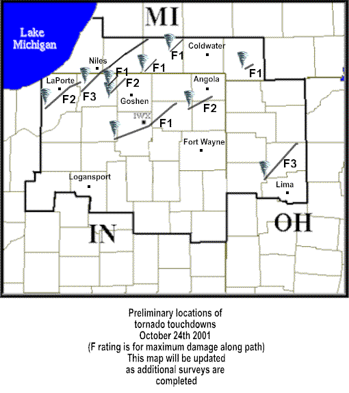
One of the largest single day tornado outbreaks across northern Indiana, southwest lower Michigan, and northwest Ohio occurred on October 24th, 2001. A total of 10 separate tornadoes were recorded, ranging in strength from F1 to F3 on the Fujita Damage Scale. One of the hardest hit areas was near South Bend, Indiana in the Crumstown area. An F3 tornado touched down 1 mile southwest of Crumstown and moved northeast across the northwest part of South Bend to just south of Niles, Michigan and into Cass and St. Joseph counties in Michigan. The path length of this tornado was 42 miles. A total of 4 separate tornado tracks were found across St. Joseph county Indiana. An F3 tornado also occurred in Van Wert and Putnam counties in Ohio. This F3 began just northwest of Delphos in Van Wert county and moved northeast into Putnam county with a path length of 32 miles. The 10 tornadoes on this day affected 14 of the 37 counties in the IWX CWA. In addition to the tornadoes, a long lived squall line which helped developed the tornadoes, produced widespread straight line wind damage across most of the remaining counties in the IWX CWA. Winds of 70 to 80 mph were reported with additional damage.
...and the number 1 event of the decade as remembered and voted on by NWS Northern Indiana Staff...
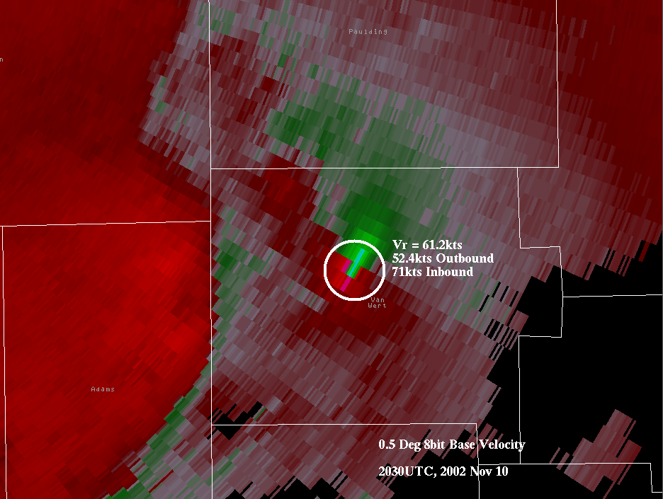
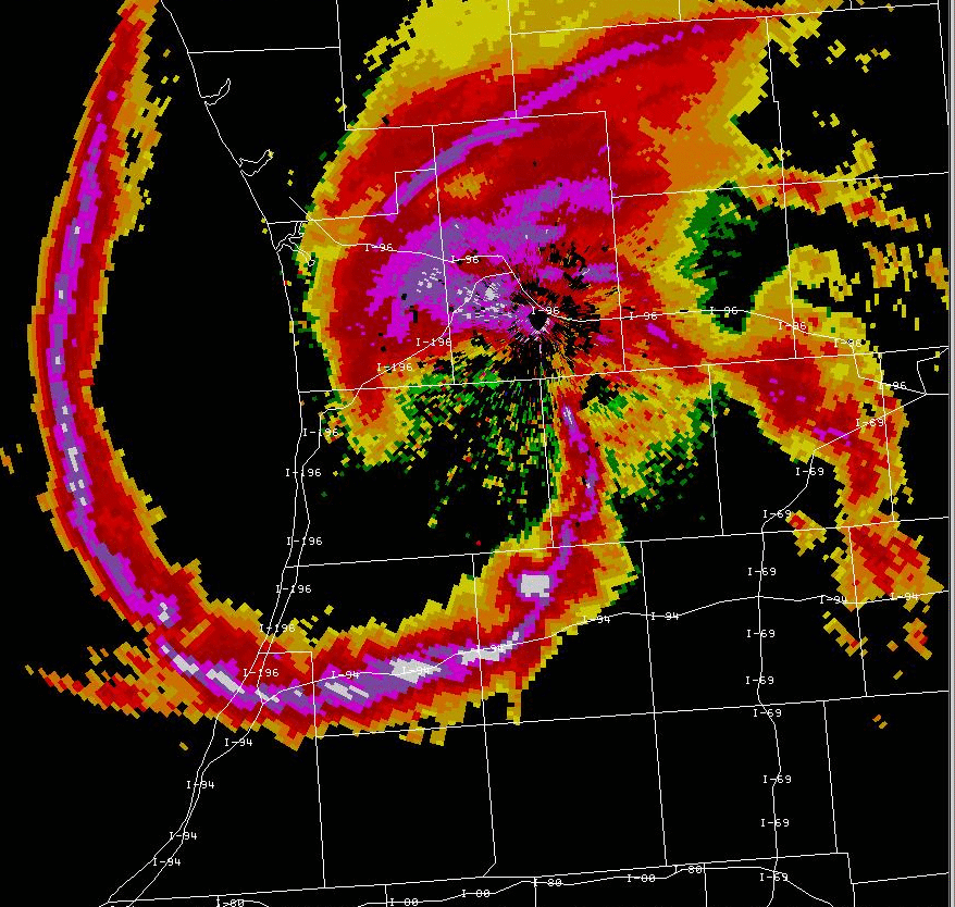
1. Van Wert Tornado Event - November 10th, 2002
A deadly fall tornado outbreak that left 4 people dead and dozens injured. A low top supercell produced tornadoes from Blackford county Indiana northeast into Henry county Ohio. Van Wert Ohio was the hardest hit area with damage indicative of a violent F4 tornado. This event made national news headlines, in part due to the life saving efforts of Emergency Manager Rick McCoy. Mr. McCoy had worked with the National Weather Service to earn his county Storm Ready recognition. As part of his Storm Ready efforts, all public buildings in Van Wert county were equipped with special warning radios by which Mr. McCoy could quickly alert when severe weather threatened. The local movie theatre was one facility that was equipped with these radios and which took a direct hit by the F4 tornado. Very little was left of the movie theatre, which had been packed full just minutes prior to tornado warnings being issued. Cars from the parking lot were hurled into the seats of the theatre as the walls and roof were completely lifted and deposited elsewhere. Because of the efforts of Mr. McCoy and the local theatre manager, the movie had been stopped when NWS tornado warnings were issued and patrons were moved to safe shelters in the interior portion of the building. Only minor injuries occurred at the theatre due to these efforts. The NWS Northern Indiana Office received a prestigious Gold Medal Award from the United States Department of Commerce for Distinguished Achievement during this event.

16. South Bend Record Rainfall - September 12th-14th, 2008
 The monthly rainfall total at South Bend Regional Airport was an amazing 13.92 inches in September 2008...which was 10.13 inches above normal. This shattered the record for the wettest September on record as well as the all-time wettest month on record. The previous wettest september on record was 1977 with 9.01 inches of precipitation. The previous all-time wettest month on record was June 1993 with 10.86 inches of precipitation. Amazingly, nearly 80 percent of the September 2008 rainfall occurred in just 3 days from September 12th through September 14th. During this 3 day period...10.88 inches of rain fell at south bend...with 10.65 inches occurring on September 13th and 14th. This means that more rain fell in just two September days than in any other entire month of September. It also means that more rain fell in just 3 days than in any other entire month on record! The greatest 24 hour rainfall total was 6.88 inches on the 13th and 14th. Official precipitation records at south bend began in 1894. The heavy precipitation in the middle of the month was due largely to the remnants of two tropical storm systems which also interacted with a stalled front across the western great lakes. Tropical storm Lowell moved into the area from the pacific ocean and interacted with the stalled frontal boundary to create the first heavy rainfall event on the 12th and 13th. A brief break in the rainfall occurred before the remnants of hurricane Ike came north and moved across the region on the 14th. All of this rain in a short period of time led to significant flooding across northwest Indiana and parts of southwest lower Michigan. Some areas that had already experienced devastating flooding in January and February once again faced high water and flooding.
17. Michigan City Single Band Snow 26” - December 19th, 2004
The largest lake effect snowstorm in several years hit northwest Indiana and portions of extreme southwest lower Michigan. An intense single band of lake effect snow extending the entire length of lake Michigan came onshore near Benton Harbor Michigan then shifted southwest to western Laporte county and eastern Porter county in Indiana. The band then remained nearly stationary from late Sunday morning through Sunday evening. Snowfall rates within the center of this intense band of lake effect snow were 2 to 3 inches per hour. The heaviest snow was confined to a small area of western Laporte county and eastern Porter county where 15 to 26 inches of snow fell. The highest accumulation was at Michigan City with 26 inches of snow. Westville reported 20 inches and Wanatah 12 inches.
18. Major Winter Flooding – January 2005
Several snow and ice storms in early January lead to an unusually high amount of water being stored on the ground in the form of snow and ice. The liquid equivalent of the snow and ice pack on the ground was between 2 and 3 inches across much of the region by mid January. A significant push of warm air moved into the area on January 12th and produced a rapid melting of all the snow and ice that was on the ground. In addition...heavy rainfall averaging over an inch also occurred during this warm up. The combination of rain and melting snow and ice lead to a huge amount of water that ran off into area rivers and streams. Significant flooding was observed on every major river system in the region. No record river levels were observed...however…many river observing points did reach into the top 5 crests ever recorded. Due to the tireless efforts of the forecasters and other staff at the National Weather Service…the NWS Northern Indiana office along with several other forecast offices and river forecast centers...received The United States Department of Commerce Silver Medal Award...the second highest award given by the department.
19. Westville Indiana 30 inch Lake Effect - February 3-4, 2009
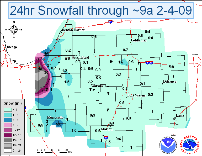
A single band of heavy lake effect snow formed over Lake Michigan on the night of February 3rd and continued into the morning hours of February 4th, 2009. This intense band affected parts of northwest Indiana and extreme southwest Lower Michigan. The heaviest snow fell in Indiana in Porter and western La Porte counties, where several locations reported more than 16 inches of snow through around 9am on the 4th. A snowfall report of 30 inches was received from Westville, Indiana with 30 mph winds, visibility down to 50 feet and rates of 3 to 4 inches per hour.
The National Weather Service office in Northern Indiana (KIWX) accurately predicted the potent cold front and damaging winds that raced across northern Indiana, southwest lower Michigan, and northwest Ohio on the afternoon of March 9th, 2002. Very strong winds in excess of 50 mph caused widespread damage that consisted of uprooted trees, downed power lines and power outages, and significant damage to numerous buildings. The KIWX Zone Forecast from Thursday, March 7th, indicated windy conditions and falling temperatures for Saturday March 9th. A Hazardous Weather Outlook was issued at 500 AM EST Friday March 8th, indicating the potential for very windy conditions. A High Wind Watch was issued at 330 pm Friday March 8th, well over 18 hours before the damaging winds began. A High Wind Warning and a very detailed Zone Forecast were issued before 400 AM EST on Saturday March 9th, nearly 9 hours before the damaging winds entered our area!
21. June 22nd, 2006 Macroburst Winds
A fast moving squall line blasted portions of northern Indiana and northwest Ohio the afternoon of June 22nd with widespread wind damage noted over a large area stretching along an west-east line from Logansport Indiana to Lima Ohio. Peak winds up to 85 mph within the macroburst area were estimated to have occurred with widespread damage to trees...crops and homes. Particularly hard hit areas included southeast Cass county, the towns of Miami, Marion, Van Buren, Liberty Center, Willshire and Lima. In addition...several weak...brief tornadoes occurred in Van Wert and Allen counties.
22. December 15-16, 2007 Thunder Snow Storm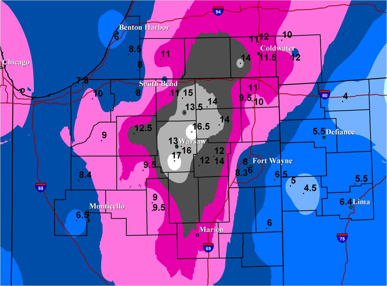
A major winter storm moved across the Great Lakes region Saturday night into Sunday morning on the 15th and 16th producing bands of heavy snow overnight, and even a few reports of thunder snow across the area. The snow came to an end late Sunday morning with a light to moderate lake effect band developing across the northwest portions of the forecast area through the afternoon hours. The heaviest snow fell from Claypool and Columbia City north into Lagrange and Coldwater. Snowfall amounts in this area were between 12 and 18 inches. The rest of the IWX forecast area received 4 to 12 inches of snow in this widespread event. Freezing rain and sleet mixed with the snow Saturday night along and east of Interstate 69 resulting in much lower snowfall totals in these areas. Thunder snow is a rare winter time phenomena, but when it does occur, snowfall rates of 2 to 4 inches per hour generally occur due to the convective nature of the event.
23. December 23rd, 2007 Thin Line Convection with Strong Wind Gusts
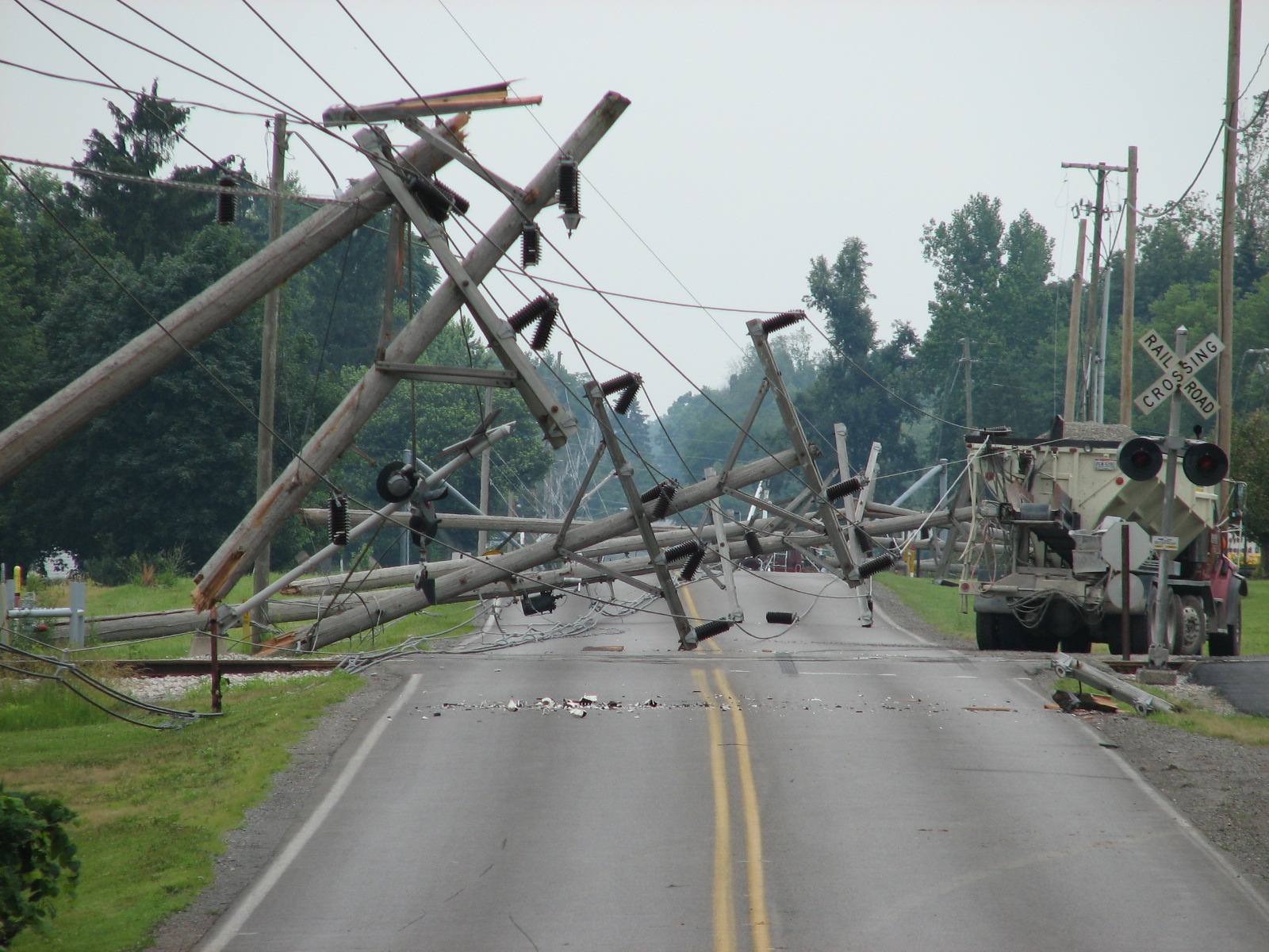
Strong gusty winds occurred along a line of convective showers that developed ahead of a cold front during the early morning hours on December 23rd. There was no thunder reported with these showers though they were convectively induced. Very impressive wind gust speeds were recorded that resulted in downed trees and power lines across the IWX forecast area. Thousands of customers were without power into Christmas due to this powerful line of showers. The area was also under a wind advisory in the wake of the line of showers as strong winds continued behind the cold front. The strongest wind gust reported was 83 mph at 6 am in Metz, which is located in Steuben county in northeast Indiana. LaPorte Indiana recorded a 72 mph gust at 418 am and the South Bend Airport reported 62 mph winds at 432 am. Winds generally ranged from 45 to 83 mph with this event and damage was widespread across the entire area.
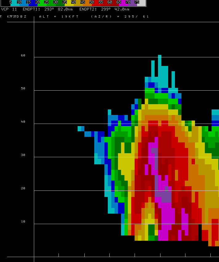
24. Softball Hail and Severe Storms April 9th, 2001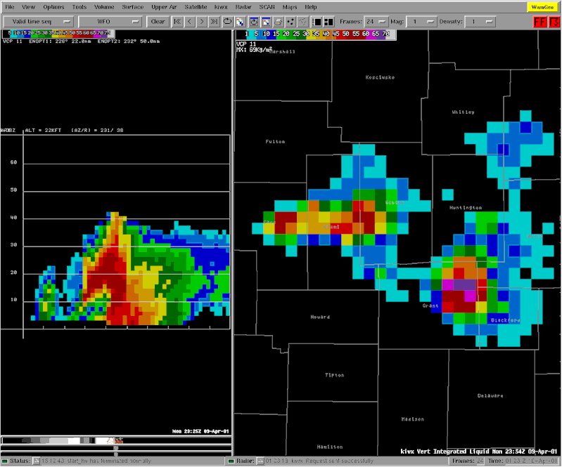
A stalled frontal boundary extended from northern Ohio west into northeast Missouri on April 9th with a developing low pressure wave near Quincy, Illinois. This wave intensified late in the afternoon as a shortwave trough embedded within the southern periphery of a significant upper jet maxima of 120 knots over Minnesota pulled out into the upper Midwest. Wind profilers at both Wolcott Indiana and Winchester Illinois indicated rapid backing low level winds and increasing speed convergence around 2500 feet coincident with rapid convective initiation along the frontal boundary from Logansport to Rensselaer.
Storms rapidly intensified with capes (convective available potential energy, a measure of parcel buoyancy) south of the frontal boundary up to 3000 J/kg. In addition...several storm scale mergers were observed with a left over outflow boundary from prior convection. Thunderstorm intensification was very rapid owing to the large amount of instability in place along and south of a Monticello to Muncie line. Deep layer shear of 50 knots was more than sufficient for supercell development. Indeed most storms along the outflow boundary exhibited strong rotation...mainly at mid-levels but two storms in particular that moved across Cass, Miami, Grant, Blackford and Jay exhibited several tornado vortex signatures (inverted red triangles) that were persistent and quite deep. In addition...a BWER (bounded weak echo region) was associated with the supercell storm that moved through Miami, Grant and Blackford counties and is often seen with tornadic storms. In addition, a VIL image (vertically integrated liquid) did indicate very large hail with this storm which dropped 4.5 inch diameter hail just north of Hartford City. However...during post event analysis...it appears surface winds from 230-250 degrees at 15 knots did not provide enough low-level shear to get the tornadic circulation aloft down to the ground even though storm motions were highly right deviant. Many reports of large hail (up to 4.5 inches) and funnel/wall clouds were received.
25. Warmth, Rain, Snow, Ice January 26th to 31st, 2002
Ice accumulations between one quarter and three quarters of an inch brought down trees and power lines and created havoc on roads across northern Indiana, southwest lower Michigan and Northwest Ohio (IWX CWA) between Wednesday January 30th and Thursday, January 31st. Prior to the ice, heavy snow blanketed northwest Indiana and southwest lower Michigan, where up to 11 inches of snow fell. Prior to this event, record breaking warm temperatures were occurring and the winter had been mild up to this point. This storm was well forecast ahead of time. The NWS Northern Indiana Office (KIWX) issued its first outlook on the storm at 521 AM EST Saturday morning, January 26th! Daily updates were issued through Tuesday, then a winter storm watch was issued Tuesday morning, January 29th. Winter weather advisories and winter storm warnings began Wednesday morning and continued through the event.
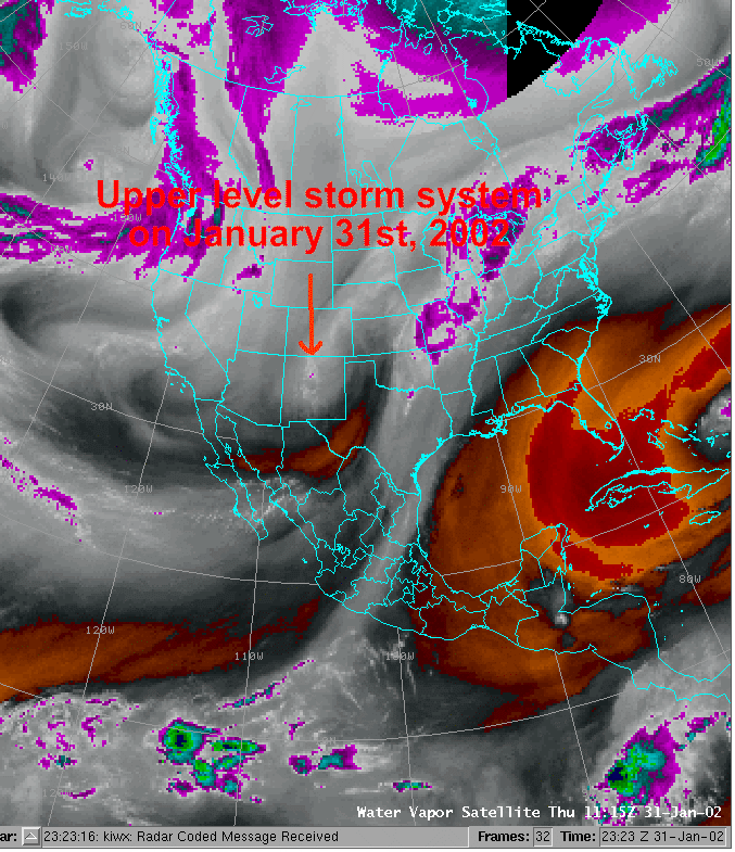 The IWX CWA experienced a wide range of weather conditions during this week. Record breaking warm temperatures began the week with highs in the 50s and 60s on Sunday and Monday. As the arctic front moved toward the region on Tuesday, moderate to heavy rains dropped between a quarter and one inch of rainfall. By early Wednesday, the front had moved into southern Indiana and we began to feel the effects of the cold Canadian air. Highs on Wednesday were only in the 30s, and enough cold air had moved into our northern areas to change the rain to snow. Central areas experienced a mix of rain, sleet and snow, while southern locations received additional rainfall.
Snowfall amounts ranged from just a few inches to almost a foot. A short wave radio operator and observer in Cassopolis, Michigan reported 11 inches of snow. Snowfall amounts from Laporte, St. Joseph, and northern Elkhart counties were between 2 and 6. After midnight Wednesday night, most of the precipitation changed over to freezing rain and sleet. Weather observers reported between one quarter and one half inch of ice accumulations on most objects. The addition of this ice on top of the heavy wet snow was too much weight for many tree limbs and power lines. By daybreak Thursday morning, residents of the tri-state region awoke to the sound of tree limbs crashing to the ground and no power. Initial reports from power companies indicated well over 100,000 people were without power on Thursday morning. Hundreds of trees and tree limbs were reported down, many of them on power lines. Roads were ice covered and treacherous, and several communities issued states of emergencies.
Story composed and written by Sam Lashley - Climate Focal Point - NWS Northern Indiana
Input received from current and former NWS Northern Indiana Staff

