National Weather Service United States Department of Commerce

NWS Jackson NOAA Weather Radio Outage May 6th-May 8th

NOAA Weather Radio broadcasts originating from NWS Jackson will be off air from Tuesday May 6th around 7 AM until Thursday May 8th around 4 PM. Remember to check for updates from other reliable sources of warning information during this outage. Read More >

Click a location below for detailed forecast.

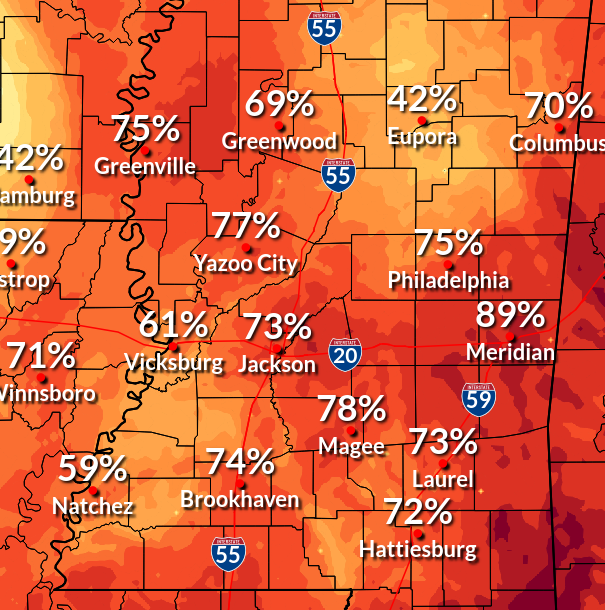
Last Map Update: Mon, May 5, 2025 at 11:24:18 pm CDT

Heavy rainfall is expected mainly Tuesday night with additional heavy rainfall possible through Thursday. Tuesday night will have the greatest threat for flooding. Areas in the far southwest will see the highest rain rates of 4-8 inches.
In addition to the heavy rainfall threat that storms crossing the area late Tuesday will bring, there could be a threat for severe weather, with damaging wind being the primary concern.
Most locations will be dry with lows in the 50s, but a few showers could move in toward daybreak over extreme southwest portions of the area.
Rain chances will be on the increase, especially during the afternoon when thunderstorms with heavy rainfall may move into western portions of the area.


SAFE Page Briefing Probabilistic Graphics Past Weather Events Precip Maps Weather History
SAFE Page Briefing Probabilistic Graphics Past Events Recent Rainfall Weather History
Forecast Discussion
Gridded Forecast Hourly Forecast Forecast Discussion Local Climate Tornado Database Submit Storm Report
    Be Prepared Estar Preparado    
    Be Prepared Estar Preparado