Numerous severe thunderstorms are expected across a broad region from the Ohio Valley to the Mid-Atlantic and Northeast States today into tonight. Swaths of damaging wind gusts are expected and some tornadoes are possible. Bertha is expected to bring tropical storm conditions to portions of the Gulf Coast from the Florida Panhandle westward to southeastern Louisiana later today and Wednesday. Read More >
Overview
|
A strong storm system and associated cold front approached eastern Kentucky on Easter Sunday, with rainfall beginning during the afternoon. As the low pressure system intensified and moved into the Ohio Valley during the evening of the 12th, wind speeds began to drastically increase across eastern Kentucky. The Kentucky Mesonet station in Dorton, (positioned at 2774 feet elevation) recorded a 79 mph wind gust. Several other gusts of 40+ mph occurred, leading to numerous instances of damage across eastern Kentucky. This includes downed trees, power lines, and structural damage, causing several roadways to be blocked for a period of time into the morning of the 13th. As many as 70,000 to 75,000 power outages were reported across eastern Kentucky. As a result of these winds, Kentucky Power reported 318 poles had to be replaced while a total of 33 miles of electric wire were downed. The Storm Reports map below gives much more detail regarding specific impacts. A few notable areas of damage include: - Pikeville where widespread tree and structural damage occurred, including to a marina on Fishtrap Lake and to the roof of a grocery store. An amateur radio and radio station tower were also blown over.
- Roof damage in Hi Hat in Floyd County. - A tree blown onto a car in Cumberland in Harlan County. - Trees blown onto homes in Barbourville. - Uprooted/snapped trees, power poles shifted several inches, and roof damage near Smilax in Leslie County. - A barn destroyed in Stinnett in Leslie County. - Roofs blown off of homes/apartments from Hollyhill to Whitley City, multiple trees downed on homes and across roadways, and hardwood trees snapped in McCreary County. - A tree falling into a house in Corbin and one on top of a car in Williamsburg. - A garage having its roof blown off and door blown out in Hazard. - A tree falling onto a home in Pippa Passes in Knott County. - A tree falling onto and destroying a home in Blackey in Letcher County. Widespread rainfall of 1-2 inches fell, with 3-4 inches over portions of southeast Kentucky and the upper Cumberland Valley. A swift water rescue took place in Bell County as a motorist became stranded in flood waters. |
 Damage to high school scoreboard in Pikeville. Courtesy WYMT. |
 |
|
 |
| Tree down on Baker Hill in Perry County. Courtesy of Johnny Ray Feltner. | Tree snapped on County Road near Kenny Lane in London. Courtesy of Team W700. | Bobby Davis Park Road in Hazard. Courtesy of Johnny Ray Feltner. |
 |
 |
 |
| Barn destroyed in Stinnett. Courtesy of WYMT. | Route 112 between McDowell and Wheelwright in Floyd County. Courtesy of local Sheriff's Office. | Vehicle stranded in flood water on Old Pineville Pike in Bell County. Courtesy of Johnny Ray Feltner. |
 |
 |
| Near Alice Lloyd College. Courtesy of Eddie Scarberry. | Near Alice Lloyd College. Courtesy of Eddie Scarberry. |
Wind
PNSJKL
KYZ044-050>052-058>060-068-069-079-080-083>088-104-106>120-131915-

Public Information Statement
National Weather Service Jackson KY
315 AM EDT Mon Apr 13 2020

...HIGHEST WIND REPORTS FROM SUNDAY EVENING TO EARLY MONDAY MORNING...

Location                     Speed     Time/Date       Lat/Lon
3 E Dorton                   79 MPH    1010 PM 04/12   37.28N/82.52W
1 WNW Yellow Mountain        55 MPH    1045 PM 04/12   37.41N/82.99W
3 WNW Pleasant               53 MPH    1209 AM 04/13   37.75N/82.63W
London-corbin Apt            49 MPH    0953 PM 04/12   37.08N/84.07W
1 WNW Big Black Mountain     46 MPH    0805 PM 04/12   36.92N/82.91W
Shelbiana                    46 MPH    0930 PM 04/12   36.87N/83.83W
Pike County Apt              45 MPH    1115 PM 04/12   37.57N/82.57W
Owingsville 4 S              45 MPH    0115 AM 04/13   38.09N/83.76W
NWS Office/Julian Carroll Ai 44 MPH    0215 AM 04/13   37.59N/83.31W
Peabody                      43 MPH    1101 PM 04/12   37.14N/83.58W
2 N Marshes Siding           42 MPH    0950 PM 04/12   36.77N/84.48W
Crown                        41 MPH    0915 PM 04/12   37.14N/82.85W
Williamsburg                 40 MPH    0937 PM 04/12   36.84N/84.21W
Jackson Apt Raws             40 MPH    1115 PM 04/12   37.59N/83.32W
Nws Jackson                  40 MPH    1120 PM 04/12   37.60N/83.32W

Observations are collected from a variety of sources with varying
equipment and exposures. We thank all volunteer weather observers
for their dedication. Not all data listed are considered official.

$$
 |
| Wind gusts over 40 mph across Kentucky. Courtesy of the Kentucky Mesonet. |
Storm Reports
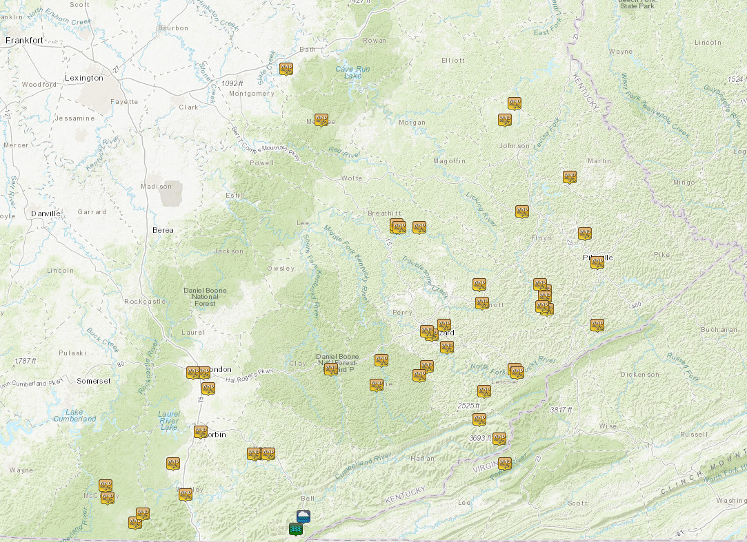 |
| Local storm reports from April 12-13. |
Rainfall
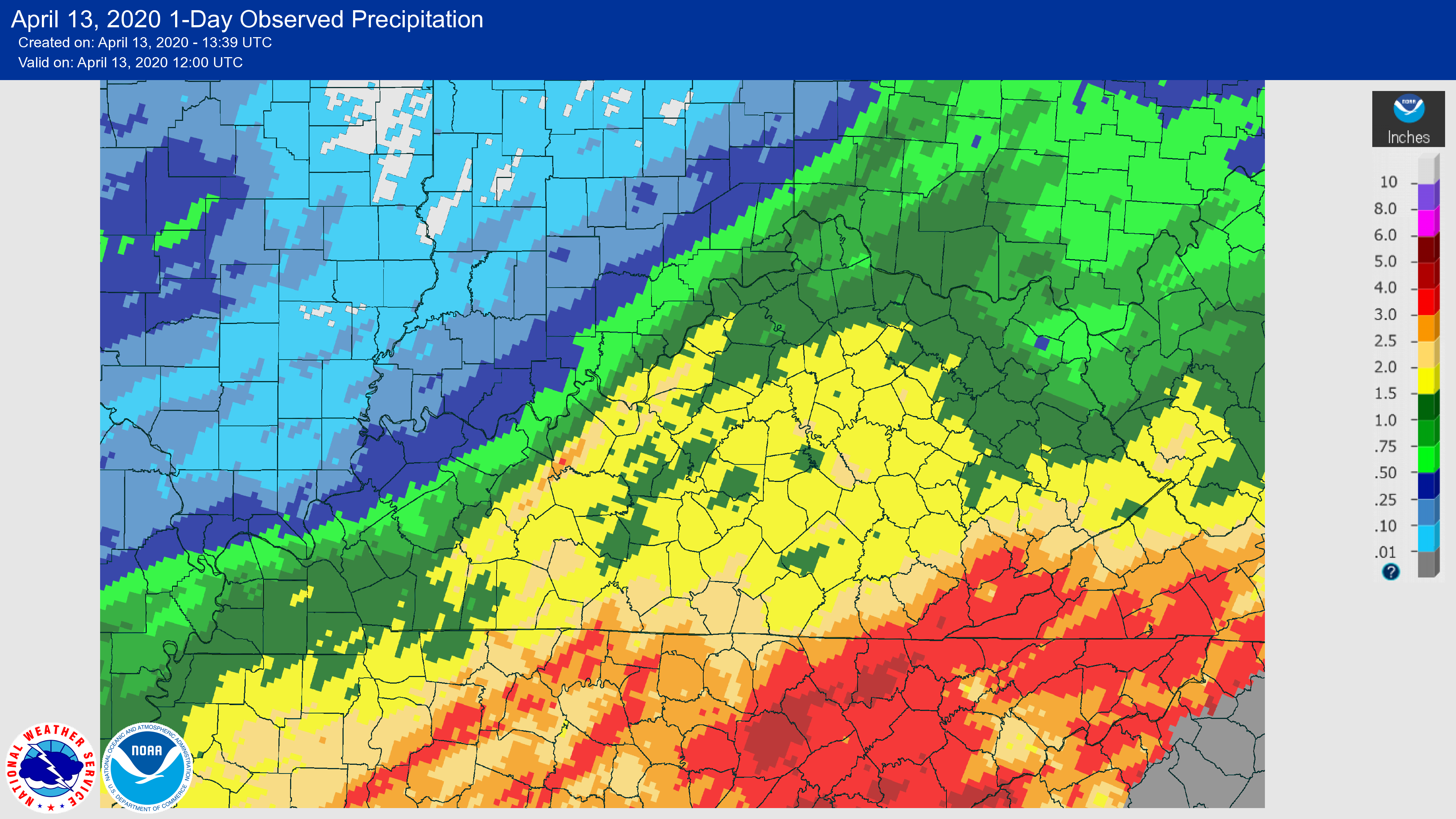 |
| Widespread rainfall amounts of 1-2 inches. Totals of 3-4 inches in the upper Cumberland Valley. |
Environment
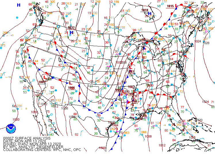 |
| Surface map analysis from 8 p.m. EDT Sunday April 12 through 11 a.m. EDT Monday April 13. |
 |
Media use of NWS Web News Stories is encouraged! Please acknowledge the NWS as the source of any news information accessed from this site. |
|