Overview
|
During the second half of March, precipitation across the region was generally minimal to nil which allowed the forest litter and dead trees/branches to become very dry. This helped set the stage for a high fire danger situation as low pressure developed over the Southern Plains during the early morning hours of March 30th, before lifting northeast and rapidly deepening during the daylight hours. In response to this deepening low, a sharp pressure gradient and strong southerly jet developed across eastern Kentucky during the morning hours of the 30th. This led to wind gusts of around 40 mph at many locations by early afternoon. In addition, a bubble of very warm and dry air over the Southeast US was pulled northward by the low-level jet and further dried by downsloping effects off of the Great Smoky and Cumberland mountains. As a result, relative humidity levels cratered to between 15 and 25 percent while air temperatures soared to near record high levels in the upper 70s to middle 80s. For some of the more sheltered valleys, this rapid warming and drying was manifested by a more than 50 degree diurnal temperature range from morning lows to late day highs. The starkest example of this was the Kentucky Mesonet station near Paintsville which started the day at 30F but recorded temperatures heating up to a summer-like 84F by late in the afternoon. The combination of strong winds, very warm temperatures, very dry fuels, and low relative humidities was very favorable for rapid fire spread and a number of wildfires ended up breaking out across eastern Kentucky. Fortunately, the impacts, in most cases, appear to have been limited to forest and brushy areas. After a brief lull in the gusts during the evening of the 30th, the most intense winds with this storm system roared across eastern Kentucky from midnight to 4 AM on the 31st along and just ahead of a line of decaying showers moving in from the west. While the showers themselves were rather weak, an intense 60-70 knot jet was howling just a few thousand feet off the ground and the shower activity aided in the mix down of the winds. Wind gusts peaked in the 40 to 60 mph range across much of the forecast area during this time frame. (Gusts were generally a bit weaker over the Big Sandy Valley and far eastern Kentucky.) Numerous power outages resulted, especially near/southwest of KY-15. However, some sizeable outages were also reported in Morgan and Floyd counties. Among the hardest hit was Owsley County, where over half the county lost power for a few hours overnight when the powerful winds blew a large tree down and damaged infrastructure near a substation. The winds also blew trees down onto power lines in multiple locations and snapped power poles, most notably in Bell, Knox, Clay, Owsley, Laurel, Rockcastle, and Whitley counties. Some structural damage was also reported, mostly to weakly constructed structures (e.g., carports). The winds however were strong enough to blow the roof off a church in Knox County and off of a home in Wolfe County. The rainfall with the shower line was relatively minimal and many of the wildland fires continued to burn at some locations during the daylight hours of the 31st, but the combination of cooling temperatures, lighter winds, and high humidity levels helped to combat the fire activity. |
Photos
 |
 |
 |
 |
| Structure Damage in the Lacy Creek Area (Courtesy of Johnny Feltner) |
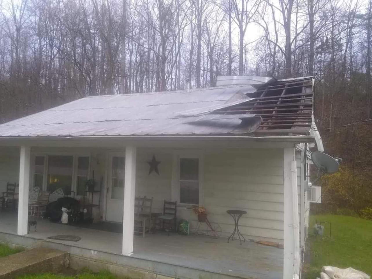
Roof Damage in the Hazel Green Area (Courtesy of Johnny Feltner) |
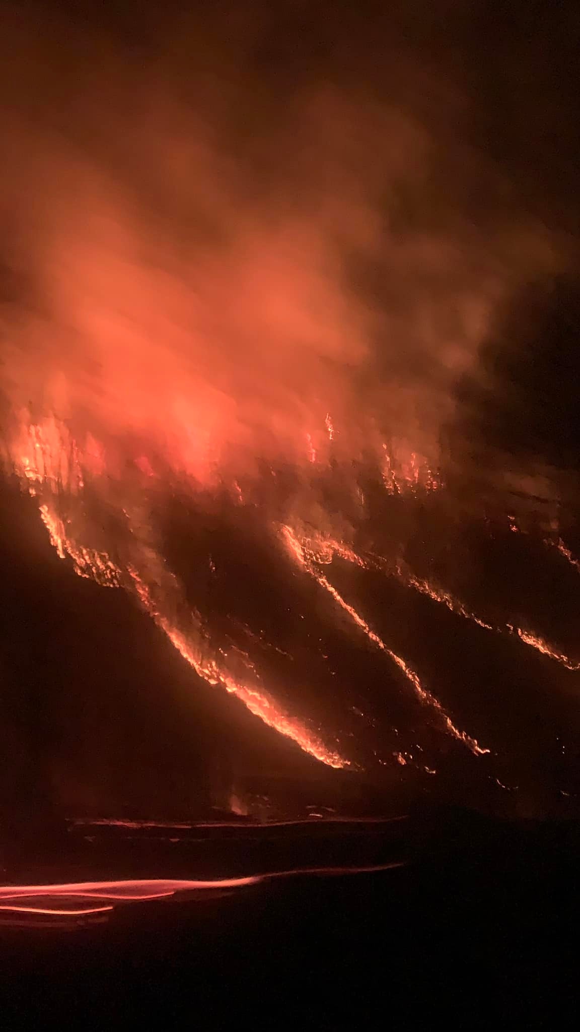
Wildfire in Lower Dry Fork Area (Courtesy of Linda Eversole Mckinney) |
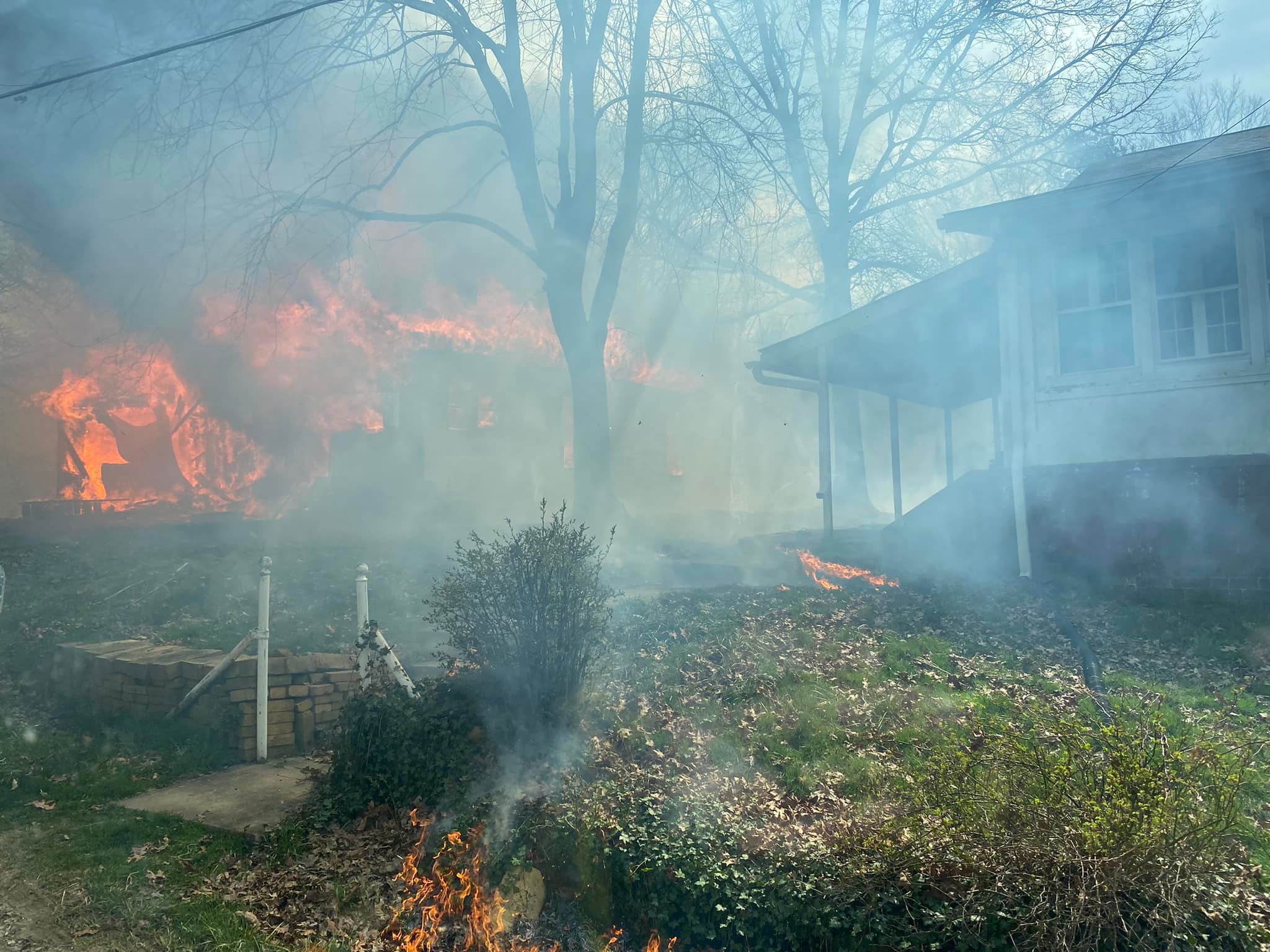
Wildland Fire Burning Structure (Courtesy of Morehead Fire Department) |
Wind Gust Reports
 ...PEAK WIND GUST REPORTS ON MARCH 30TH AND MARCH 31ST...
Location Speed Time/Date Lat/Lon
Bath County
Owingsville 4 S 50 MPH 0900 PM 03/30 38.09N/83.76W
Bell County
Middlesboro Apt 38 MPH 0135 AM 03/31 36.62N/83.73W
Yellow Creek RAWS 23 MPH 0226 AM 03/31 36.60N/83.70W
Breathitt County
NWS Jackson 51 MPH 0303 AM 03/31 37.60N/83.32W
Jackson RAWS 45 MPH 0256 AM 03/31 37.59N/83.32W
Jackson 14 SE 44 MPH 0305 AM 03/31 37.43N/83.18W
Jackson 3 SE 43 MPH 0300 AM 03/31 37.54N/83.34W
Jackson 14 ESE 26 MPH 0335 AM 03/31 37.46N/83.16W
Clay County
Peabody RAWS 42 MPH 0301 AM 03/31 37.14N/83.58W
Harlan County
Harlan 24 E 45 MPH 0555 AM 03/31 36.92N/82.91W
Harlan Apt 32 MPH 1015 AM 03/31 36.87N/83.37W
Jackson County
McKee 5 S 43 MPH 0145 AM 03/31 37.36N/83.97W
Johnson County
Paintsville 4 W 28 MPH 0150 PM 03/30 37.83N/82.88W
Knott County
Hindman 5 N 44 MPH 0100 AM 03/31 37.41N/82.99W
Knox County
Barbourville 3 E 50 MPH 0255 AM 03/31 36.87N/83.83W
Laurel County
London-Corbin Apt 55 MPH 1244 AM 03/31 37.08N/84.07W
Letcher County
Whitesburg 2 NW 34 MPH 1100 PM 03/30 37.13N/82.84W
Martin County
Big Sandy RAWS 37 MPH 0556 PM 03/30 37.75N/82.63W
Big Sandy Apt 37 MPH 0415 AM 03/31 37.75N/82.63W
McCreary County
Whitley City 3 N 43 MPH 0125 AM 03/31 36.77N/84.48W
Montgomery County
Mount Sterling Apt 46 MPH 1215 AM 03/31 38.05N/83.98W
Morgan County
West Liberty 2 SW 53 MPH 0245 AM 03/31 37.90N/83.27W
Owsley County
Booneville 2 S 38 MPH 0800 PM 03/30 37.45N/83.69W
Perry County
Hazard Apt 51 MPH 0315 AM 03/31 37.39N/83.26W
Pike County
Pikeville 13 S 53 MPH 0130 AM 03/31 37.28N/82.52W
Pike County Apt 41 MPH 0335 AM 03/31 37.57N/82.57W
Pulaski County
Somerset 7 NNE 51 MPH 1215 AM 03/31 37.18N/84.56W
Somerset Apt 46 MPH 1155 PM 03/30 37.05N/84.62W
Somerset RAWS 39 MPH 1201 AM 03/31 37.05N/84.61W
Rockcastle County
Wabo 54 MPH 0124 AM 03/31 37.31N/84.39W
Rowan County
Morehead 4 NE 50 MPH 0145 AM 03/31 38.22N/83.48W
Triangle Mtn RAWS 41 MPH 0302 AM 03/31 38.18N/83.41W
Wayne County
Monticello Apt 52 MPH 1227 AM 03/31 36.85N/84.85W
Monticello 4 NW 48 MPH 1215 AM 03/31 36.87N/84.90W
Monticello 45 MPH 1246 AM 03/31 36.96N/84.83W
Whitley County
Williamsburg Apt 59 MPH 0215 AM 03/31 36.80N/84.20W
Wolfe County
Koomer Ridge RAWS 53 MPH 0209 AM 03/31 37.78N/83.63W
...PEAK WIND GUST REPORTS ON MARCH 30TH AND MARCH 31ST...

Location                     Speed     Time/Date       Lat/Lon

Bath County
Owingsville 4 S              50 MPH    0900 PM 03/30   38.09N/83.76W

Bell County
Middlesboro Apt              38 MPH    0135 AM 03/31   36.62N/83.73W
Yellow Creek RAWS            23 MPH    0226 AM 03/31   36.60N/83.70W

Breathitt County
NWS Jackson                  51 MPH    0303 AM 03/31   37.60N/83.32W
Jackson RAWS                 45 MPH    0256 AM 03/31   37.59N/83.32W
Jackson 14 SE                44 MPH    0305 AM 03/31   37.43N/83.18W
Jackson 3 SE                 43 MPH    0300 AM 03/31   37.54N/83.34W
Jackson 14 ESE               26 MPH    0335 AM 03/31   37.46N/83.16W

Clay County
Peabody RAWS                 42 MPH    0301 AM 03/31   37.14N/83.58W

Harlan County
Harlan 24 E                  45 MPH    0555 AM 03/31   36.92N/82.91W
Harlan Apt                   32 MPH    1015 AM 03/31   36.87N/83.37W

Jackson County
McKee 5 S                    43 MPH    0145 AM 03/31   37.36N/83.97W

Johnson County
Paintsville 4 W              28 MPH    0150 PM 03/30   37.83N/82.88W

Knott County
Hindman 5 N                  44 MPH    0100 AM 03/31   37.41N/82.99W

Knox County
Barbourville 3 E             50 MPH    0255 AM 03/31   36.87N/83.83W

Laurel County
London-Corbin Apt            55 MPH    1244 AM 03/31   37.08N/84.07W

Letcher County
Whitesburg 2 NW              34 MPH    1100 PM 03/30   37.13N/82.84W

Martin County
Big Sandy RAWS               37 MPH    0556 PM 03/30   37.75N/82.63W
Big Sandy Apt                37 MPH    0415 AM 03/31   37.75N/82.63W

McCreary County
Whitley City 3 N             43 MPH    0125 AM 03/31   36.77N/84.48W

Montgomery County
Mount Sterling Apt           46 MPH    1215 AM 03/31   38.05N/83.98W

Morgan County
West Liberty 2 SW            53 MPH    0245 AM 03/31   37.90N/83.27W

Owsley County
Booneville 2 S               38 MPH    0800 PM 03/30   37.45N/83.69W

Perry County
Hazard Apt                   51 MPH    0315 AM 03/31   37.39N/83.26W

Pike County
Pikeville 13 S               53 MPH    0130 AM 03/31   37.28N/82.52W
Pike County Apt              41 MPH    0335 AM 03/31   37.57N/82.57W

Pulaski County
Somerset 7 NNE               51 MPH    1215 AM 03/31   37.18N/84.56W
Somerset Apt                 46 MPH    1155 PM 03/30   37.05N/84.62W
Somerset RAWS                39 MPH    1201 AM 03/31   37.05N/84.61W

Rockcastle County
Wabo                         54 MPH    0124 AM 03/31   37.31N/84.39W

Rowan County
Morehead 4 NE                50 MPH    0145 AM 03/31   38.22N/83.48W
Triangle Mtn RAWS            41 MPH    0302 AM 03/31   38.18N/83.41W

Wayne County
Monticello Apt               52 MPH    1227 AM 03/31   36.85N/84.85W
Monticello 4 NW              48 MPH    1215 AM 03/31   36.87N/84.90W
Monticello                   45 MPH    1246 AM 03/31   36.96N/84.83W

Whitley County
Williamsburg Apt             59 MPH    0215 AM 03/31   36.80N/84.20W

Wolfe County
Koomer Ridge RAWS            53 MPH    0209 AM 03/31   37.78N/83.63W
Observations are collected from a variety of sources with varying
equipment and exposures. We thank all volunteer weather observers
for their dedication. Not all data listed are considered official.
Environment
A warm front lifted across the Commonwealth early on the morning of the 30th. Behind the boundary, a very warm and dry air mass moved in on strong southerly flow during the daylight hours on the 30th. Figure 2 is a surface snapshot from 19z (3 PM) and shows temperatures (red lines) near or exceeding 80 degrees while relative humidity values (green lines) were between 15 and 25 percent. The combination of hot temperatures, very low humidity levels, and wind gusts to around 40 mph resulted in very favorable conditions for rapid fire spread. The Hot Dry Windy Index Analysis (HDWI) in Figure 3 shows that this combination of heat, low humidity, and gusty winds were near the 95th percentile, a level that favors extreme fire activity during seasons when available fuels are sufficiently dry.
The radar surface analysis shows a decaying line of showers and storms approaching overnight. While the resulting rainfall was minimal, a tight surface pressure gradient (Figure 4), the anomalous 65 knot jet at 850 mb (Figure 5), and steepening lapse rates in the low levels resulted in multiple hours of strong to damaging wind gusts from late evening of the 30th into the early morning hours of the 31st.
 |
| Figure 1: Radar/Surface Analysis 7 AM March 30th to 7 AM March 31st |
 |
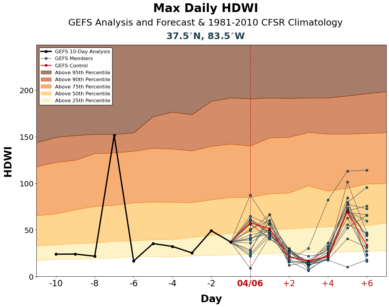 |
| Figure 2: Surface Temperature (red line), Relative Humidity RH<40% (dashed line), Pressure (black line), and Wind at 3 PM, March 30th | Figure 3: Hot-Dry Windy Index with Reanalysis (peak at -7 Day is March 30th) |
 |
 |
| Figure 4: Tight Surface Pressure Field and Pressure 2-hour Pressure Change at 1 AM, March 31st | Figure 5: 850 mb Analysis at 1 AM (Wind Barbs over Eastern Kentucky Indicate 65 Knot Flow) |
 |
Media use of NWS Web News Stories is encouraged! Please acknowledge the NWS as the source of any news information accessed from this site. |
|


