
Dangerous heat will expand from the Gulf Coast into the Southern Plains and Desert Southwest through week's end. Additional extreme heat impacting the Pacific Northwest will shift to the northern Plains by the weekend. Tropical Storm Bertha is expected to continue to impact portions of the northern Gulf Coast from the western Florida Panhandle to southeastern Louisiana through tonight. Read More >
Overview
|
The most widespread severe thunderstorm activity in many months broke out across eastern Kentucky on Tuesday, May 16th. A warm front lifted to near the Mountain Parkway during the morning hours, ushering in a muggy airmass for those locations to the south of the Parkway. Sun shining on this juicy air mass helped build up moderate amounts of instability south of the warm front as temperatures warmed into the upper 70s to mid 80s there. Meanwhile, persistent cloud cover and a weak northeasterly breeze kept temperatures cooler and conditions much more stable north of the front. Scattered showers and storms were observed near and north of the warm front earlier in the day, but a majority of the activity did not arrive until afternoon when a wave of low pressure rode directly along the stalled boundary. This low acted as a trigger for lift while also increasing the wind shear sufficiently to favor rotating supercell thunderstorms across most of eastern Kentucky. Several of the thunderstorms, especially near the Mountain Parkway southward to US-421, exhibited classic supercell structure and strong rotation. Within this corridor, multiple swaths of hail greater than 1 inch in diameter were observed. Additionally, the greatest turning of the winds in the low-levels (typically needed for the formation of tornadoes) occurred right along and south of the warm front (which was situated near the Mountain Parkway). It was within this zone that a storm moving along/near the warm front dropped a brief EF-1 tornado in the vicinity of the Hendricks and Foraker communities of Magoffin County moments past 4:45 PM. In the hour and 45 minutes preceding the tornado, a number of residents upstream of the tornado reportedly observed a funnel cloud along the Estill/Powell County line. However, an all-day search from a NWS Jackson Storm Survey Team turned up no tornado damage (though much of that area is remote forest land inaccessible from roadways). Further east in Pike County, another supercell moving along this same boundary pummeled the Kimper area with hail up to the size of tennis balls. A few dozen miles south of the boundary, another storm which organized over Leslie County dropped hail up to golf-ball size near Hazard. Further south from the warm front, storms tended to be less supercellular and instead generated strong outflows leading to bowing storm lines which produced damaging wind gusts. |
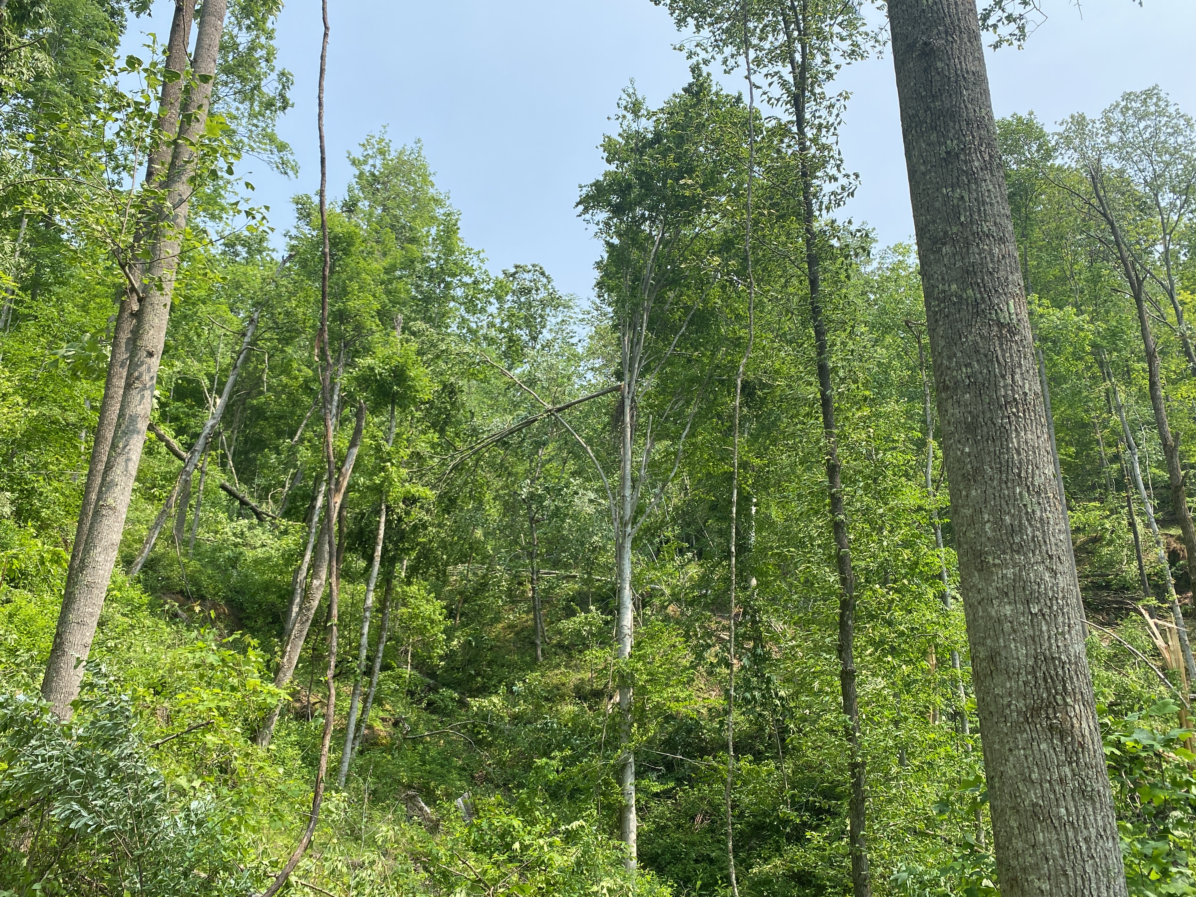
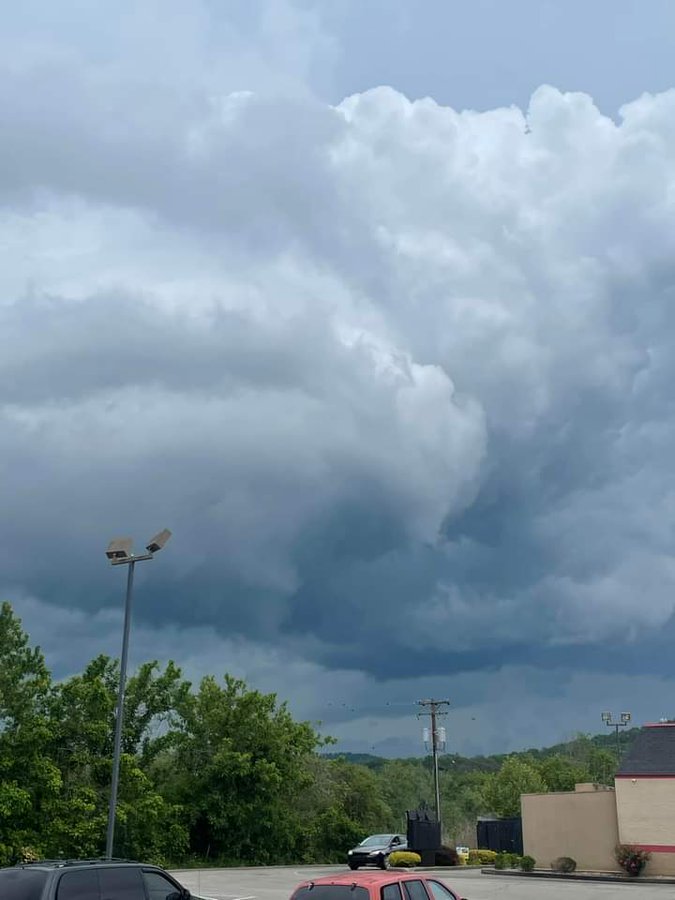 Rotating Supercell Passing near Powell/Estill County Line as Seen from West Irvine (Courtesy of Johnny Ray Feltner) |
Tornadoes:
|
Tornado - Foraker
Track Map 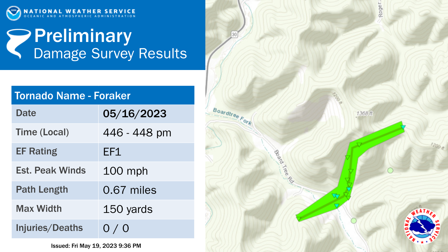 
|
||||||||||||||||
The Enhanced Fujita (EF) Scale classifies tornadoes into the following categories:
| EF0 Weak 65-85 mph |
EF1 Moderate 86-110 mph |
EF2 Significant 111-135 mph |
EF3 Severe 136-165 mph |
EF4 Extreme 166-200 mph |
EF5 Catastrophic 200+ mph |
 |
|||||
 |
 |
 |
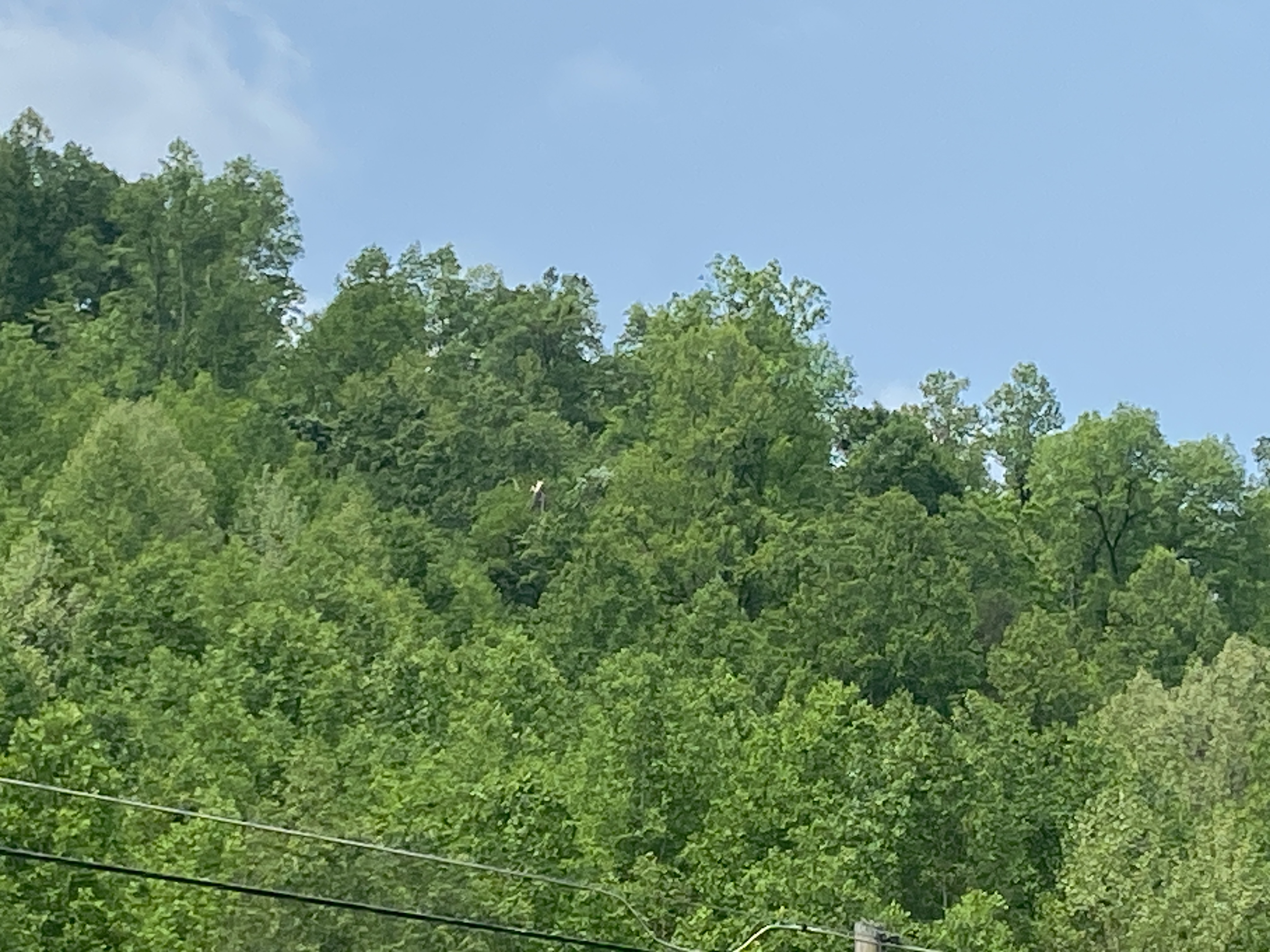
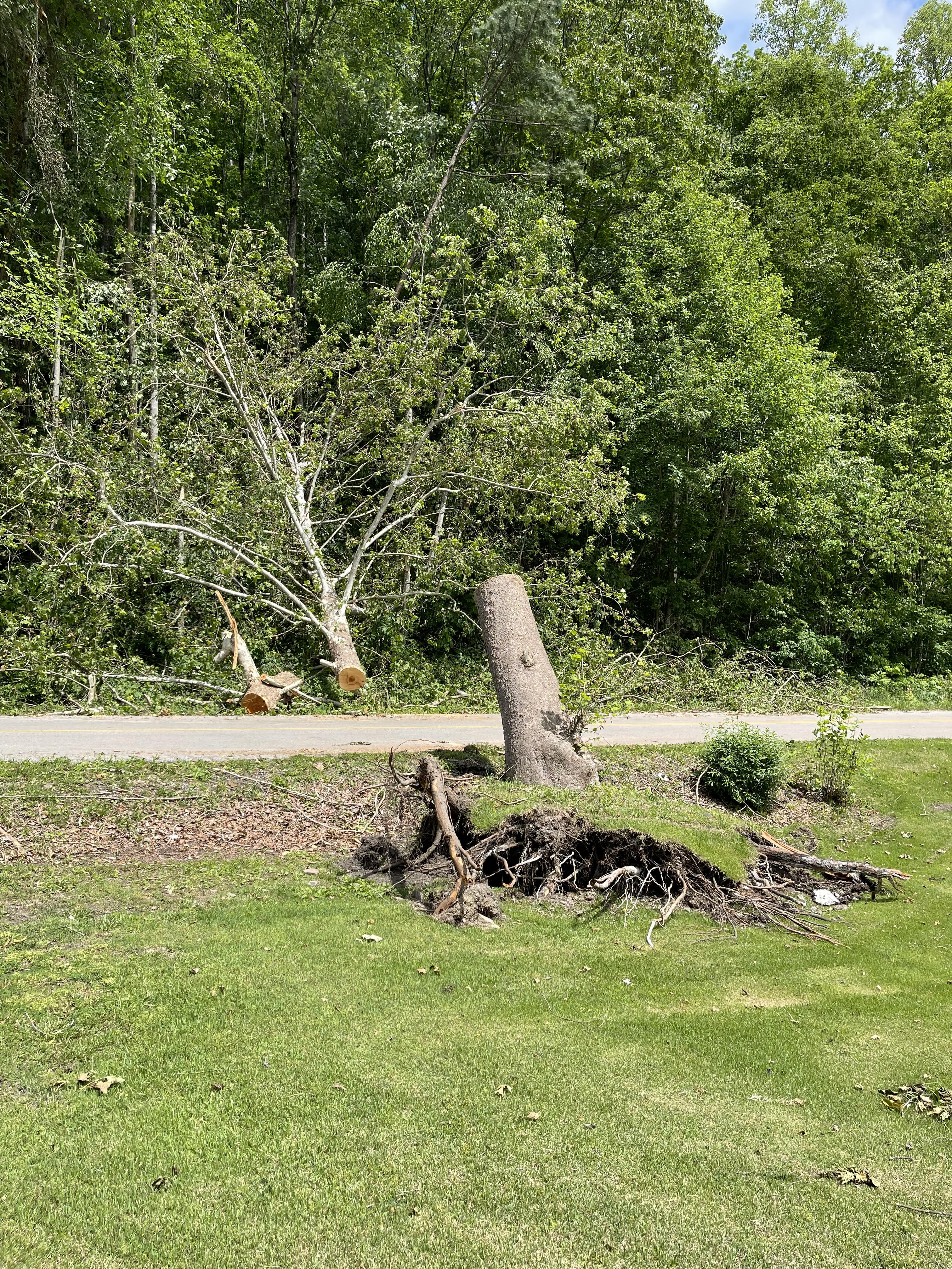
| Tree Damage on Steep Slope South of Board Tree Rd. Courtesy of NWS Storm Survey |
Minimal Damage at Mouth of Hollow (More Extensive Tree Damage Visible up the Hollow on the Left) Courtesy of NWS Storm Survey |
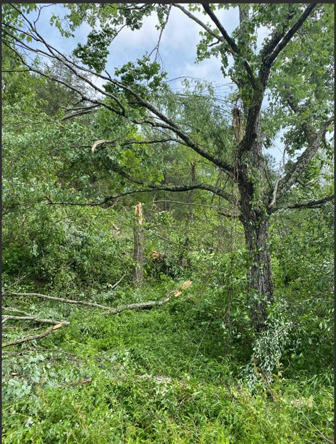
Extensive Tree Damage along Mid-Slope of Ridge North of Board Tree Rd. Courtesy of NWS Storm Survey |
 |
 |
 |
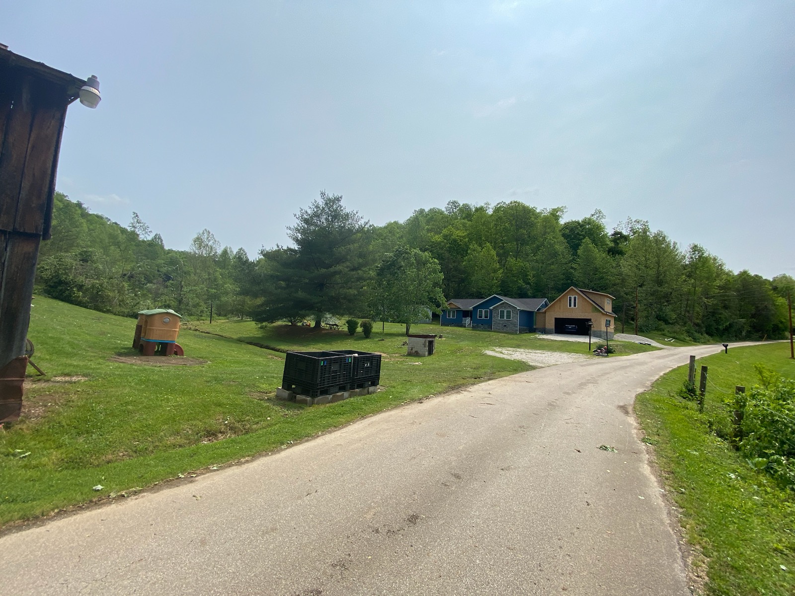
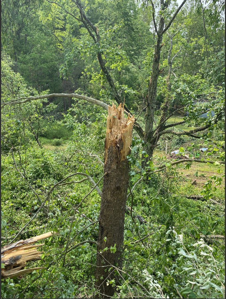
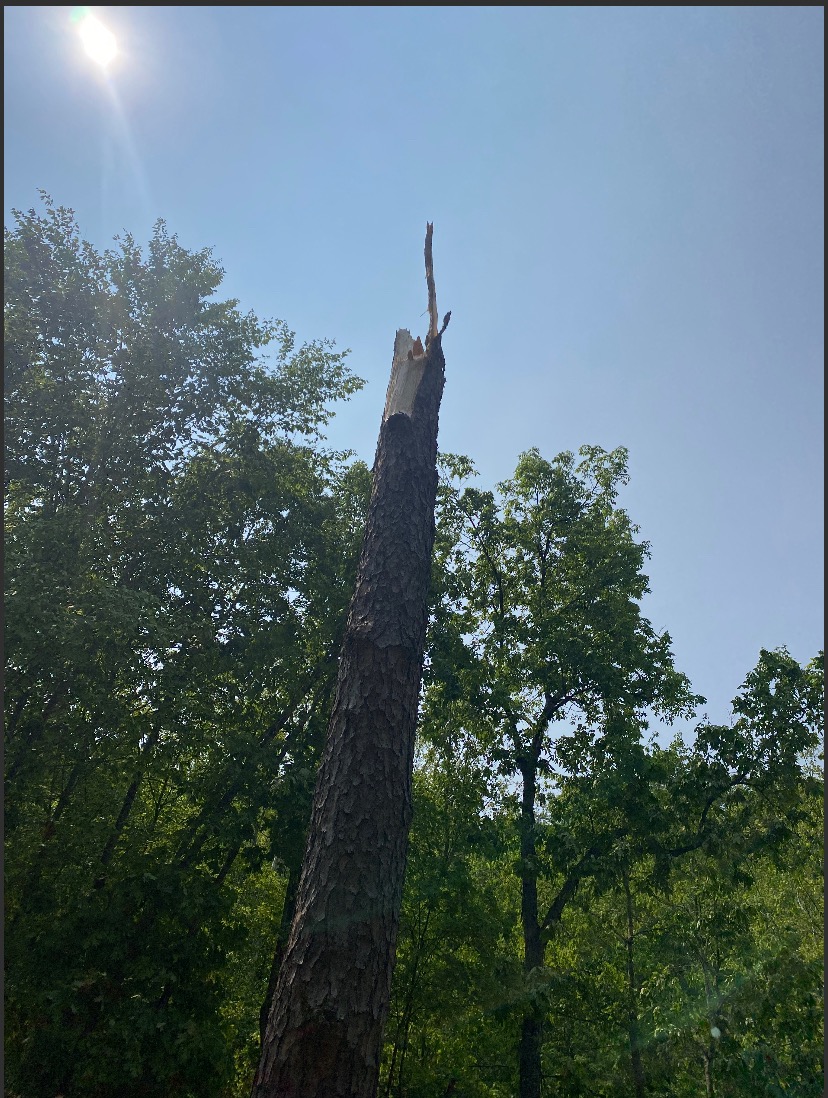
| Snapped Pine Tree Trunk in Hollow North of Board Tree Rd. Courtesy of NWS Storm Survey |
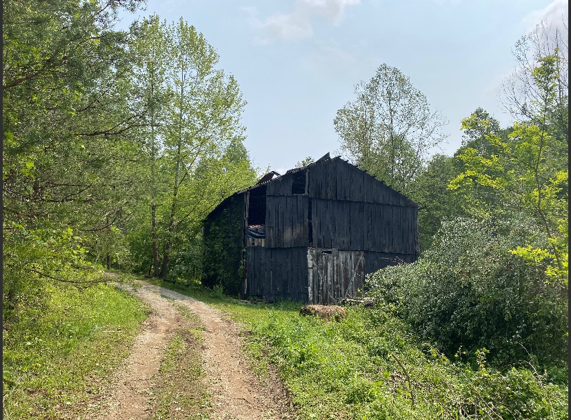
Roof Damage on Old Barn north of Board Tree Rd. Courtesy of NWS Storm Survey |
Tree Damage in Hollow North of Board Tree Rd. Courtesy of NWS Storm Survey |
Wind & Hail:
Wind Damage Pictures
Wind damage was observed at many locations between the Mountain Parkway and US-421 and back into Rockcastle County. Damage reports were more sporadic elsewhere. A few of the more notable wind reports are pictured below:
 |
 |
 |
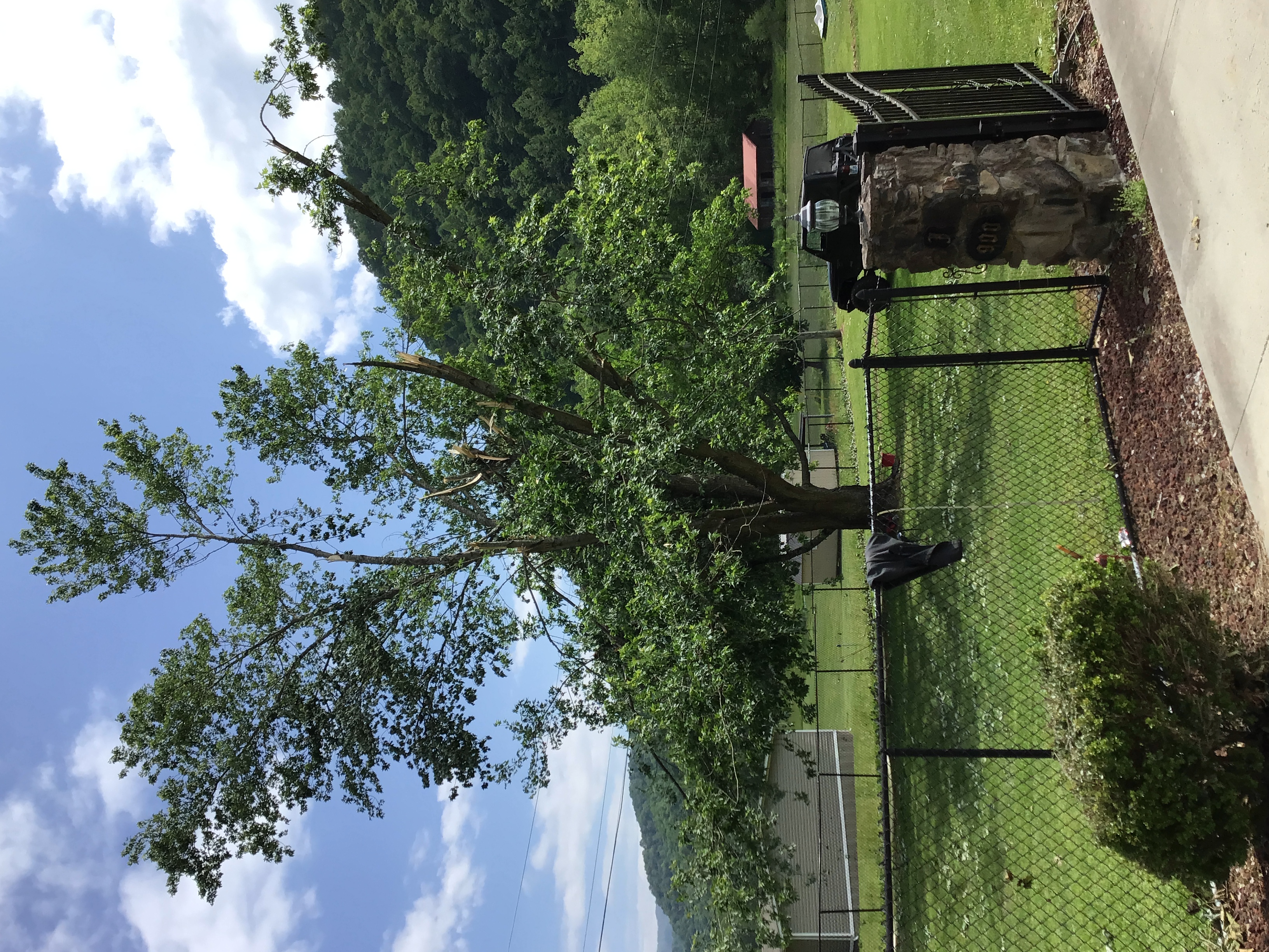 |
| Large Cottonwood Tree Partially Uprooted across KY-568 (Harlan County) (Courtesy of NWS Storm Survey) |
Tree Snapped, Likely By Rear Flank Downdraft, at Board Tree Branch (Magoffin County) (Courtesy of NWS Storm Survey) |
Tree Fallen onto a Home (Owsley County) (Courtesy of Stephanie Carmack Loman) |
Healthy Maple Tree at Ikes Branch with Multiple Large Limbs Broken (Harlan County) (Courtesy of NWS Storm Survey) |
Large Hail Pictures
The largest hail fell from an intense supercell over central Pike County. Severe hail was also observed near Hazard and near the Powell/Estill County border. Some of the most notable hail reports are pictured below:
 |
 |
 |
 |
| Approximately Tennis Ball Size Hailstone on Grassy Branch at Raccoon (Pike County) (Courtesy of Pike County Mugshots & News) |
Hailstones on Grassy Branch of Raccoon (Pike County) (Courtesy of Jeff May) |
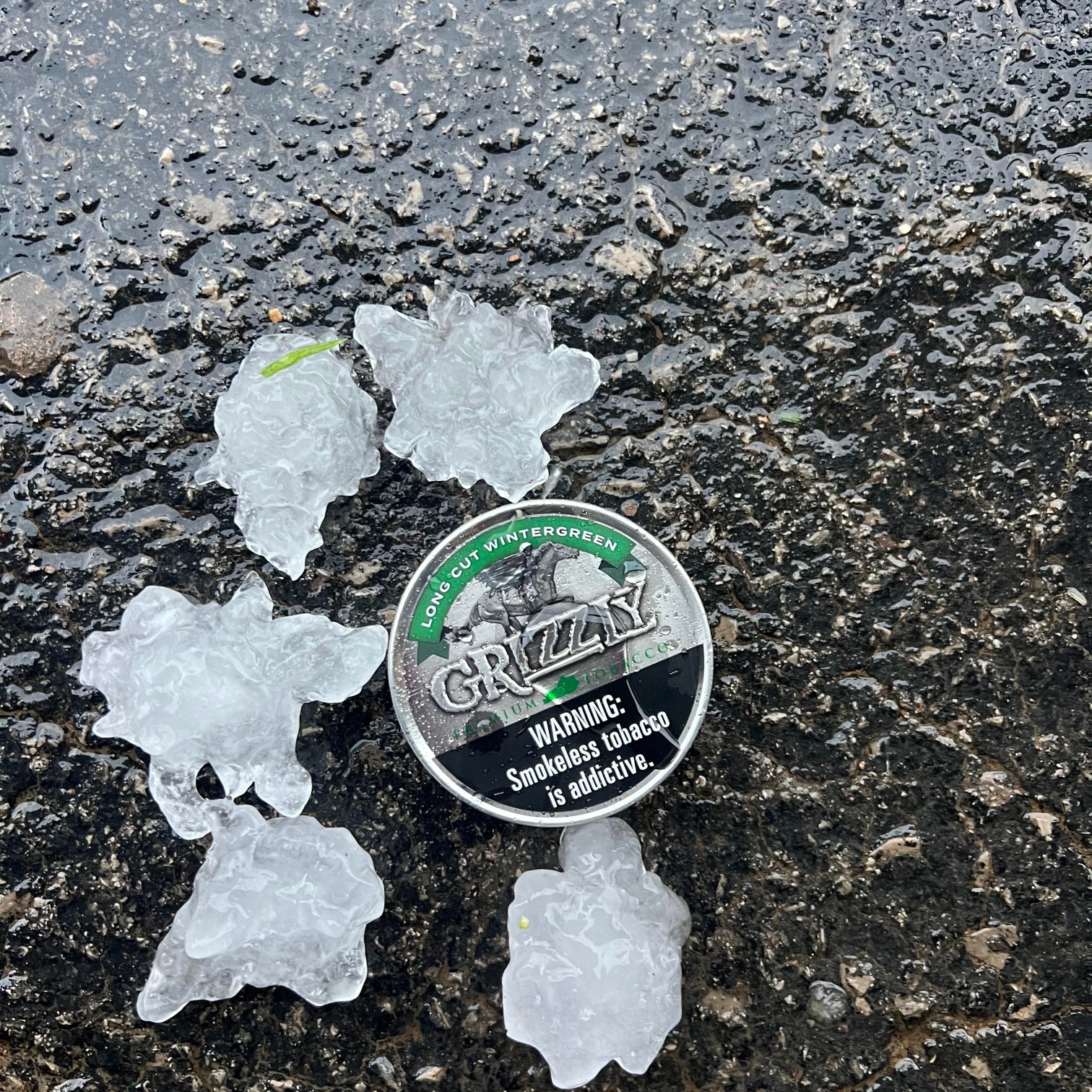
Hailstone at Kimper (Pike County) (Courtesy of Pike County Mugshots & News) |
Hailstone at Kimper Beside Dip Can (Pike County) (Courtesy of Pike County Mugshots & News) |
 |
 |
 |
| Golf Ball Size Hailstone at Lawson Branch on John's Creek (Pike County) (Courtesy of Kim@blufeatherz) |
Large Hail at Buckhorn Dam (Perry County) (Courtesy of Lucas Amis) |
Golf Ball Size Hail at Vaughn's Mill (Powell County) (Courtesy of Dustin Skidmore) |
Radar
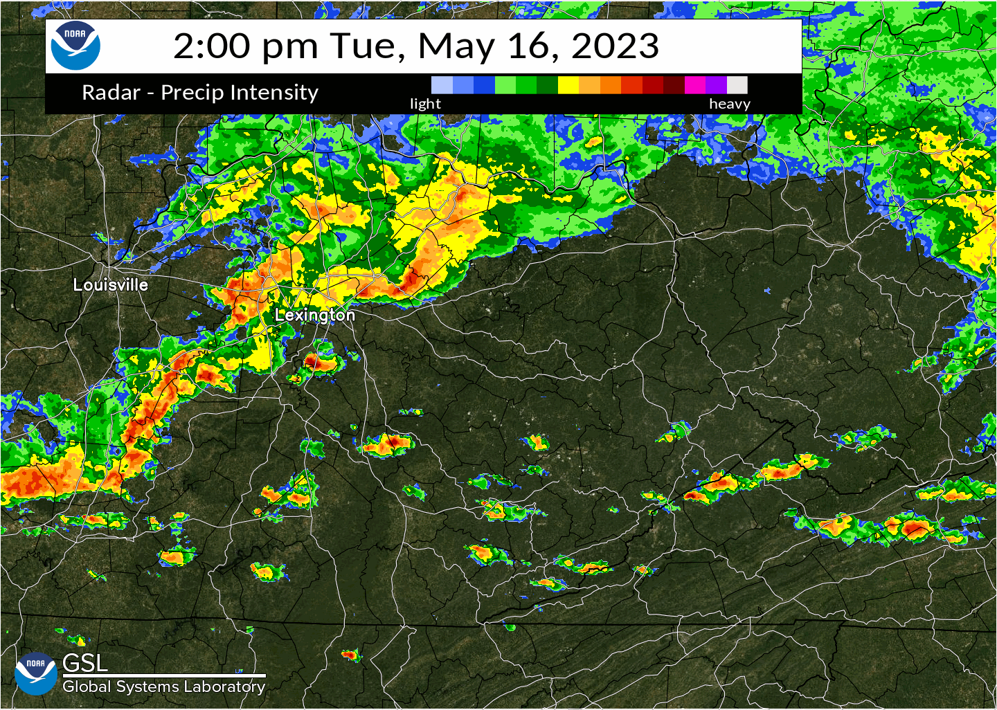 |
| Radar Loop from 2 to 6 PM on May 16, 2023 |
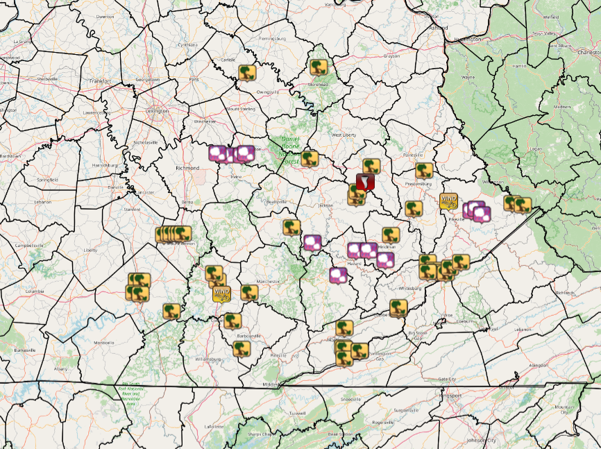
Storm Reports
 |
|
Storm Reports From May 16th, 2023 |
..TIME... ...EVENT... ...CITY LOCATION... ...LAT.LON...
..DATE... ....MAG.... ..COUNTY LOCATION..ST.. ...SOURCE....
..REMARKS..
0210 PM Tstm Wnd Dmg 2 WSW Bethel 38.24N 83.90W
05/16/2023 Bath KY Dept of Highways
Bath County Highway Garage reported numerous
trees down along KY-11 between Sharpsburg
and Bethel.
0231 PM Hail Wooton 37.18N 83.30W
05/16/2023 E0.75 inch Leslie KY 911 Call Center
0303 PM Tstm Wnd Dmg 1 NE Cranston 38.27N 83.43W
05/16/2023 Rowan KY Dept of Highways
Rowan County Dept. of Highway reported 5
trees down along KY-377 between MM 5 and MM
6. Time estimated from radar.
0303 PM Hail Iron Mound 37.81N 84.04W
05/16/2023 E1.75 inch Estill KY Public
Public reported approximately golf-ball size
hail just north of the intersection of
Cressy Rd and Hawkins Cemetery Rd.
0305 PM Hail 1 NE Engle 37.82N 84.10W
05/16/2023 E0.75 inch Estill KY Emergency Mngr
0309 PM Tstm Wnd Dmg 2 SSE Indian Lakes Park 37.39N 84.45W
05/16/2023 Rockcastle KY 911 Call Center
Tree down along highway 3245 about a half
mile west of the U.S. 150 intersection. Time
estimated from radar.
0310 PM Tstm Wnd Dmg Brodhead 37.40N 84.42W
05/16/2023 Rockcastle KY 911 Call Center
Tree down on a vehicle at 142 Proffitt
Street. Time estimated from radar.
0310 PM Tstm Wnd Dmg Brodhead 37.40N 84.41W
05/16/2023 Rockcastle KY 911 Call Center
Tree down in Broadhead along Highway 1505.
Time estimated from radar.
0311 PM Tstm Wnd Dmg 1 E Brodhead 37.40N 84.40W
05/16/2023 Rockcastle KY 911 Call Center
Tree down along Highway 1505 near the
intersection of Highway 1326. Time estimated
from radar.
0312 PM Tstm Wnd Dmg 1 WNW Lake Linville 37.40N 84.37W
05/16/2023 Rockcastle KY 911 Call Center
Multiple trees down at 1490 Barnett Road.
Time estimated from radar.
0312 PM Hail 1 W Vaughns Mill 37.81N 83.94W
05/16/2023 M1.75 inch Powell KY Public
Picture on social media shows hail up
golf-ball size near Vaughn Mill.
0313 PM Tstm Wnd Dmg 1 NNW Lake Linville 37.40N 84.35W
05/16/2023 Rockcastle KY 911 Call Center
Tree down on Red Bird Road near Lake
Linville Road. Time estimated from radar.
0313 PM Tstm Wnd Dmg 1 N Renfro Valley 37.40N 84.33W
05/16/2023 Rockcastle KY 911 Call Center
Tree down on a powerline off of Koa
Campground Road. Time estimated from radar.
0315 PM Hail 1 NE Vaughns Mill 37.82N 83.91W
05/16/2023 E1.00 inch Powell KY Trained Spotter
Nickel to quarter-sized hail covering the
ground.
0324 PM Tstm Wnd Dmg 2 S Science Hill 37.15N 84.63W
05/16/2023 Pulaski KY 911 Call Center
Report of a tree down on a
powerline off of Highway 1247 near the
intersection of Raleigh Road. Time estimated
from radar.
0325 PM Tstm Wnd Dmg 3 W Somerset 37.09N 84.65W
05/16/2023 Pulaski KY Public
Tree down along Highway 80 near Somerset.
Time estimated by radar.
0325 PM Tstm Wnd Dmg 3 SE Science Hill 37.15N 84.60W
05/16/2023 Pulaski KY 911 Call Center
Tree down off of Nelson Valley Road near the
intersection of Jeffries Drive. Time
estimated from radar.
0328 PM Tstm Wnd Dmg Somerset 37.08N 84.61W
05/16/2023 Pulaski KY 911 Call Center
Powerline down on Bourne Avenue close to the
intersection of Murphy Avenue. Time
estimated from radar.
0332 PM Tstm Wnd Dmg Lewis Creek 37.00N 82.90W
05/16/2023 Letcher KY Dept of Highways
A tree was reported down on KY 3403 near the
Harlan County line in the vicinity of Partridge.
The time of the event is radar estimated.
0345 PM Tstm Wnd Dmg 3 S Mount Victory 36.99N 84.40W
05/16/2023 Pulaski KY 911 Call Center
Tree down near the 2000 block of Old Whitney
Road. Time estimated from radar.
0345 PM Tstm Wnd Dmg Camp Lewis 37.59N 83.18W
05/16/2023 Breathitt KY NWS Employee
Tree down along Highway 30. Time estimated
from radar.
0349 PM Tstm Wnd Dmg 2 NE Guage 37.62N 83.17W
05/16/2023 Breathitt KY NWS Employee
2 trees down along Highway 30. Time
estimated from radar.
0351 PM Tstm Wnd Dmg 1 SSE Pittsburg 37.15N 84.10W
05/16/2023 Laurel KY 911 Call Center
A tree was blown down on North Laurel Road
just north of the London city limits.
0352 PM Tstm Wnd Dmg East Bernstadt 37.19N 84.12W
05/16/2023 Laurel KY 911 Call Center
A tree was reported to have been blown down
in East Bernstadt. The time of the event is
radar estimated.
0355 PM Tstm Wnd Dmg 1 SSW Gosneyville 37.79N 83.49W
05/16/2023 Wolfe KY Dept of Highways
A couple of trees reported down on KY 746
near mile marker 5. Time estimated from
radar.
0400 PM Hail Buckhorn 37.35N 83.47W
05/16/2023 E1.50 inch Perry KY Other Federal
Army Corp. of Engineer employee relayed a
picture of large hail that fell at Buckhorn
Lake Dam.
0403 PM Tstm Wnd Gst 1 ESE London-Corbin Air 37.08N 84.07W
05/16/2023 M53 MPH Laurel KY ASOS
ASOS station KLOZ London-Corbin Apt.
0403 PM Tstm Wnd Dmg Gray 36.94N 84.00W
05/16/2023 Knox KY Dept of Highways
Tree down in Gray along Kentucky Highway
233. Time estimated from radar.
0410 PM Tstm Wnd Dmg Lake 37.09N 83.89W
05/16/2023 Laurel KY 911 Call Center
Trees and large limbs were reported to have
been blown down on Marydell Road near Bush.
0420 PM Hail 1 NW Bulan 37.31N 83.18W
05/16/2023 E1.25 inch Perry KY Public
Picture posted to social media shows
approximately half dollar-sized hail at
Hazard Animal Shelter. Time estimated from
radar.
0423 PM Tstm Wnd Dmg 1 WSW Langley 37.53N 82.80W
05/16/2023 Floyd KY 911 Call Center
A tree was reported down on KY Hwy 777 near
the Kentucky Hydrocarbon Company Plant.
0425 PM Hail 1 WSW Ritchie 37.31N 83.10W
05/16/2023 E1.75 inch Knott KY Public
Picture on social media show approximately
golf-ball size hail south of Fisty, KY. Time
estimated from radar.
0434 PM Tstm Wnd Dmg King 36.79N 83.94W
05/16/2023 Knox KY Dept of Highways
Tree down on Kentucky Highway 1809. Time
estimated from radar.
0435 PM Hail 1 SSW Amburgey 37.26N 82.99W
05/16/2023 E1.00 inch Knott KY Dept of Highways
0442 PM Tstm Wnd Dmg 1 WNW Salyersville 37.75N 83.08W
05/16/2023 Magoffin KY Dept of Highways
Highway department reported a tree down on
US 460 between mm 0 and 9. Time estimated
from radar.
0442 PM Tstm Wnd Dmg Soft Shell 37.39N 82.95W
05/16/2023 Knott KY Law Enforcement
Trees were reported to have been blown down
on KY 1087.
0445 PM Tstm Wnd Gst 4 NE Boldman 37.57N 82.57W
05/16/2023 M52 MPH Pike KY AWOS
AWOS station KPBX Pike County Apt.
0446 PM Tstm Wnd Dmg 1 ENE Foraker 37.67N 83.12W
05/16/2023 Magoffin KY NWS Storm Survey
Large limbs of tree broken, and
all facing towards the path of the tornado -
likely an inflow into the storm on the
outskirts of the tornado.
0447 PM Tornado 1 ENE Foraker 37.67N 83.12W
05/16/2023 Magoffin KY NWS Storm Survey
An NWS Survey Team, in conjunction with
Magoffin County Emergency Management,
confirmed that an EF-1 tornado
touched down on a hillside southwest of
Board Tree Rd, crossed the road and then
traveled through the holler/drainage along
Williams Arnett Cemetery Road. It then
climbed up the adjacent ridgeline before
weakening and dissipating. Several
structures sustained minor damage, and many
trees were snapped or uprooted. More
information can be found in the associated
Public Information Statement.
0447 PM Tstm Wnd Dmg 1 ENE Foraker 37.67N 83.12W
05/16/2023 Magoffin KY NWS Storm Survey
High winds caused softwood trunks to snap.
All trees were facing towards the path of
the tornado - likely an inflow into the
storm on the outskirts of the tornado.
0452 PM Tstm Wnd Dmg Rhea 36.90N 83.26W
05/16/2023 Harlan KY 911 Call Center
A tree was reported to have been downed
along Ky 522 near Russell Road. The time of
the event is radar estimated.
0453 PM Tstm Wnd Dmg 1 S Cowcreek 37.43N 83.61W
05/16/2023 Owsley KY Dept of Highways
Owsley County State Garage reported a tree
down on KY-1768 about a half of a mile down
from the intersection of KY-28 and KY-1768.
0455 PM Tstm Wnd Dmg 2 N Ehkhorn Mine 37.25N 82.71W
05/16/2023 Letcher KY Dept of Highways
A tree was reported to have been blown down
on KY 1469 near the Pike County line. The
time of the event is radar estimated.
0458 PM Tstm Wnd Dmg Mcroberts 37.21N 82.67W
05/16/2023 Letcher KY Dept of Highways
A tree was reported to have been blown down
in McRoberts. The time of the event is radar
estimated.
0500 PM Tstm Wnd Dmg 1 NNW Dunham 37.20N 82.65W
05/16/2023 Letcher KY Dept of Highways
Several trees were reported to have bene
blown down onto KY 3409 between Jenkins and
McRoberts. The time of the event is radar
estimated.
0500 PM Tstm Wnd Dmg 1 SW Merna 36.78N 83.26W
05/16/2023 Harlan KY Public
A tree was blown down onto KY Hwy 1556. The
time of the event is radar estimated.
0500 PM Tstm Wnd Dmg Lenarve 36.80N 83.27W
05/16/2023 Harlan KY 911 Call Center
A tree was downed onto KY Hwy 3001 near the
Harlan Country Club. The time of the event
is radar estimated.
0501 PM Hail 2 NNE Raccoon 37.52N 82.42W
05/16/2023 E2.50 inch Pike KY Emergency Mngr
Report of video provided to Pike County EM.
At least Tennis Ball size hail. Time
estimated from radar.
0502 PM Tstm Wnd Dmg Smith 36.74N 83.26W
05/16/2023 Harlan KY 911 Call Center
A tree was reported to have been blown down
onto Ky Hwy 987 near Martins Fork Lake. The
time of the event is radar estimated.
0502 PM Tstm Wnd Dmg Merna 36.79N 83.26W
05/16/2023 Harlan KY 911 Call Center
A tree was reported to have been blown down
onto KY 3001 near Mountain Oaks Drive. The
time of the event is radar estimated.
0505 PM Tstm Wnd Dmg 1 NW Shelby Gap 37.22N 82.56W
05/16/2023 Pike KY 911 Call Center
A tree was reported to have been blown down
onto Ky Hwy 805 near Big Shelby Creek Road.
0505 PM Tstm Wnd Dmg 1 ENE Burdine 37.19N 82.59W
05/16/2023 Letcher KY Dept of Highways
A tree was blown down onto KY Highway 805
about 1 to 2 miles from the Pike County
line. The time of the event is radar
estimated.
0505 PM Tstm Wnd Dmg 1 NW Fleming-Neon 37.20N 82.71W
05/16/2023 Letcher KY Public
Report from mPING: Large limbs were blown
down.
0508 PM Tstm Wnd Dmg 1 ESE Auxier 37.73N 82.73W
05/16/2023 Floyd KY 911 Call Center
A tree was reported to have been blown down
on KY Hwy 302 between on half mile and one
mile before Dewey Dam.
0509 PM Hail 3 NW Kimper 37.53N 82.39W
05/16/2023 M1.75 inch Pike KY Public
Report forwarded via twitter off of Lawsons
Branch near Highway 194.
0509 PM Tstm Wnd Dmg 1 NNE Cranks 36.78N 83.16W
05/16/2023 Harlan KY NWS Storm Survey
NWS Storm Survey showed straight line winds
with damage consistent with approximately 70
mpg wind gusts. There were a few felled
trees (some partially uprooted) and some
trees with large branches broken off. Winds
followed the direction of the valley floor
along highway 568. One resident stated the
winds lasted only a few minutes.
0509 PM Tstm Wnd Dmg 1 NNE Cranks 36.78N 83.16W
05/16/2023 Harlan KY 911 Call Center
A tree was reported down near 1106 KY
Highway 568 near Cranks. The event time is
radar estimated.
0510 PM Hail Kimper 37.50N 82.35W
05/16/2023 E1.75 inch Pike KY Emergency Mngr
Video provided to Pike County EM showed golf
ball size hail. Time estimated from radar.
0513 PM Tstm Wnd Dmg 3 WSW Ashcamp 37.25N 82.49W
05/16/2023 Pike KY Law Enforcement
Pike County EM referred to dispatch for
reports of trees down in southern Pike
County. Time estimated from radar.
0515 PM Tstm Wnd Dmg 2 NNE Board Tree 37.56N 82.15W
05/16/2023 Pike KY Dept of Highways
Dept of highways reported a tree down in the
town of Freeburn. Time estimated from radar.
0515 PM Tstm Wnd Dmg Partridge 37.01N 82.90W
05/16/2023 Letcher KY Dept of Highways
A tree was blown down onto Old US 119 at
Partridge. The time of the event is radar
estimated.
0518 PM Tstm Wnd Dmg 2 NE Majestic 37.55N 82.08W
05/16/2023 Pike KY Dept of Highways
Dept of highways reported tree down in the
town of Majestic. Time estimated from radar.
Environment
A warm front lifted north and stalled near the Mountain Parkway during the morning of Tuesday, May 16th as shown in Figure 1. An area of low pressure then moved east along the stalled frontal boundary across the Commonwealth, deepening as it moved through eastern Kentucky during the afternoon. The low then moved into Virginia by early Tuesday evening, allowing a cold front to sweep through the region.
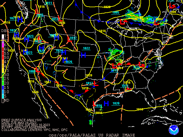 |
| Figure 1: Surface Analysis Loop from 5 AM (0900Z) until 8 PM(0000Z) LT May 16th, 2023 |
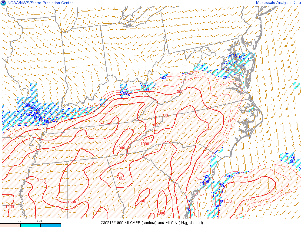
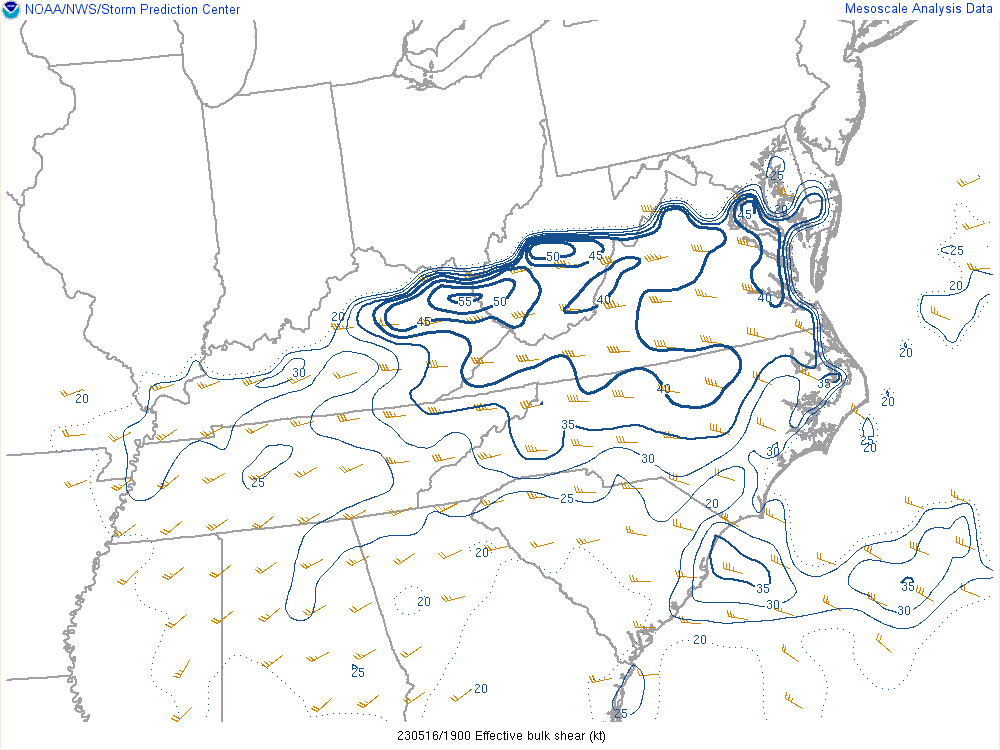
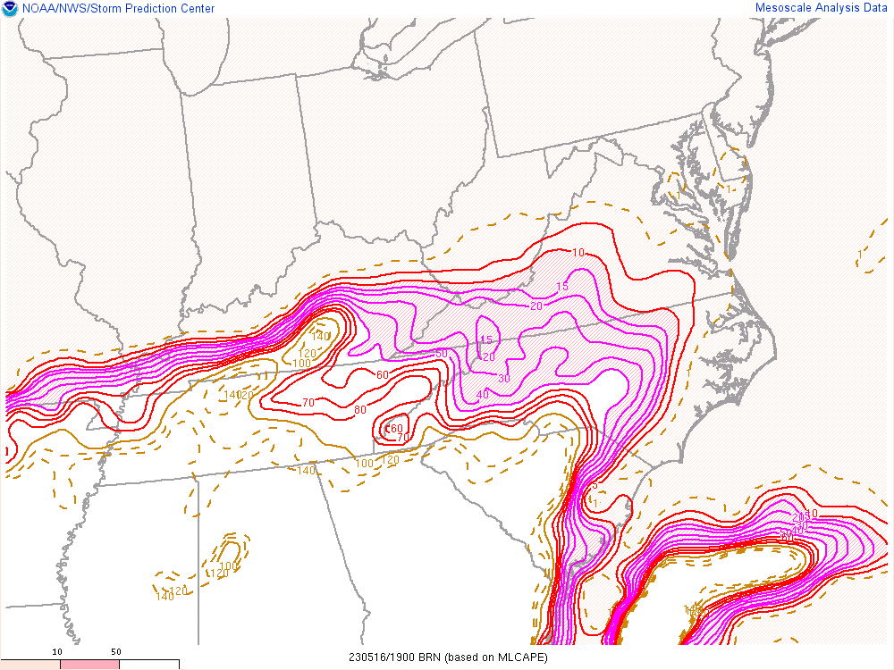
The atmosphere became increasingly supportive of supercell thunderstorms Tuesday afternoon. For the ensuing environmental discussion, all mesoanalysis graphics are from 3 PM (19z) on Tuesday, just as the storms were developing and quickly intensifying. Most of eastern Kentucky saw moderate MLCAPE (Figure 2) coupled with moderate to strong Effective Shear (Figure 3). The balance of these two parameters was indicated by the Bulk Richardson Number (Figure 4), which shows most of the area ranging from 10-45, favorable for supercell formation. Additionally, the Supercell Composite parameter also showed higher values across eastern Kentucky, supporting a higher likelihood of supercells.
 |
 |
 |
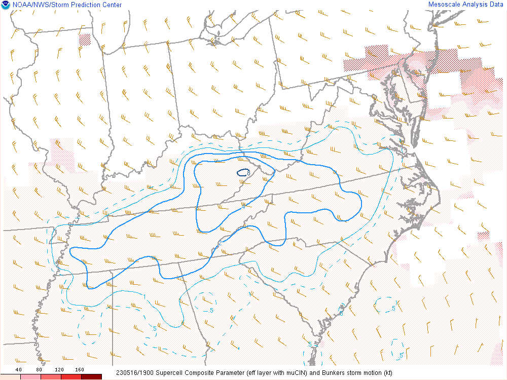 |
| Figure 2: MLCAPE (J/kg) | Figure 3:Effective Shear (kts) | Figure 4: Bulk Richardson Number | Figure 5: Supercell Composite |
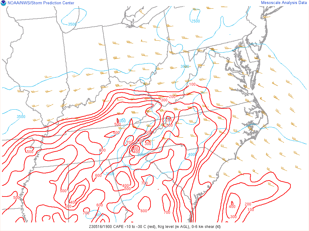
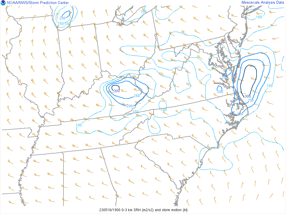
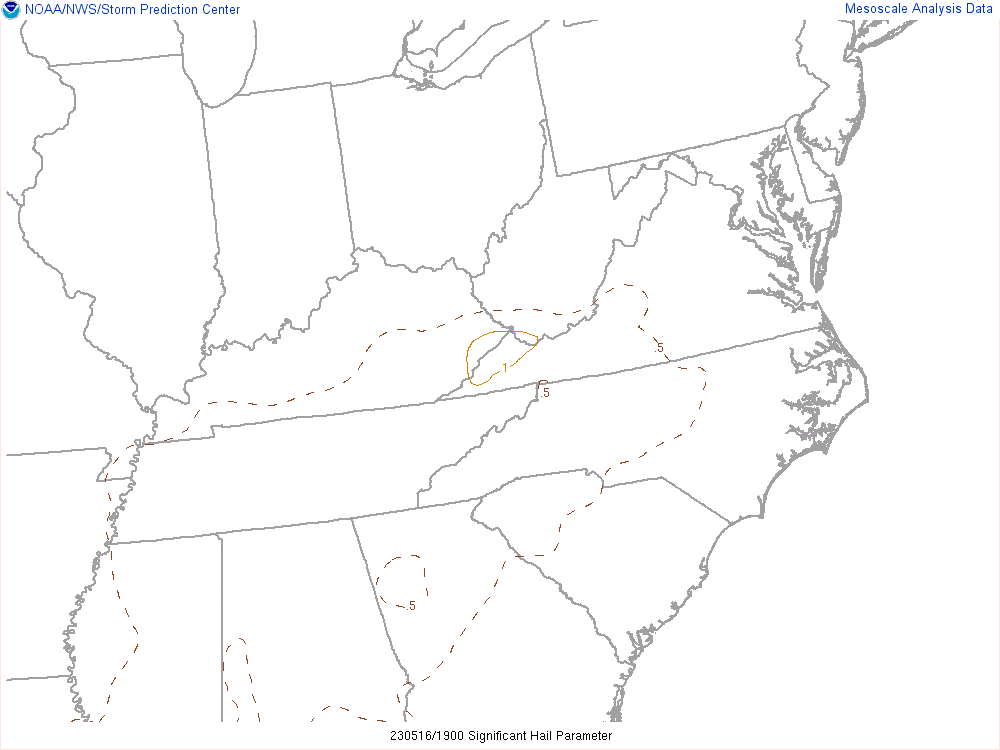
Hail CAPE, which are CAPE values within a temperature layer of -10C to -30C within the atmosphere, were mainly 300-500 J/kg, generally weak to moderate values; however, 0-3 km Storm Relative Helicity values were more moderate in the 200 to 300 m2/s2 range, showing a better potential for rotating updrafts. There is a greater chance of severe hail within rotating updrafts, as the hail will have a longer residence (growth) time within the updraft. The Significant Hail Parameter (SHIP), which is an indicator that distinguishes between significant hail (2 inches or greater in diameter) and non-significant hail (less than 2 inches in diameter), was also showing values of 0.5 to 1.0. Values greater than 1.0 tend to be associated with significant hail. The main limiting factor for the SHIP on this day was weak lapse rates in the mid-levels of the storm. Even so, Pike County saw SHIP values exceeding 1.0 and also experienced the largest hail stones, the largest of which exceeded the 2.0 inch diameter threshold.
 |
 |
 |
| Figure 6: Hail CAPE | Figure 7: 0-3 km Storm Relative Helicity | Figure 8: Significant Hail Parameter |
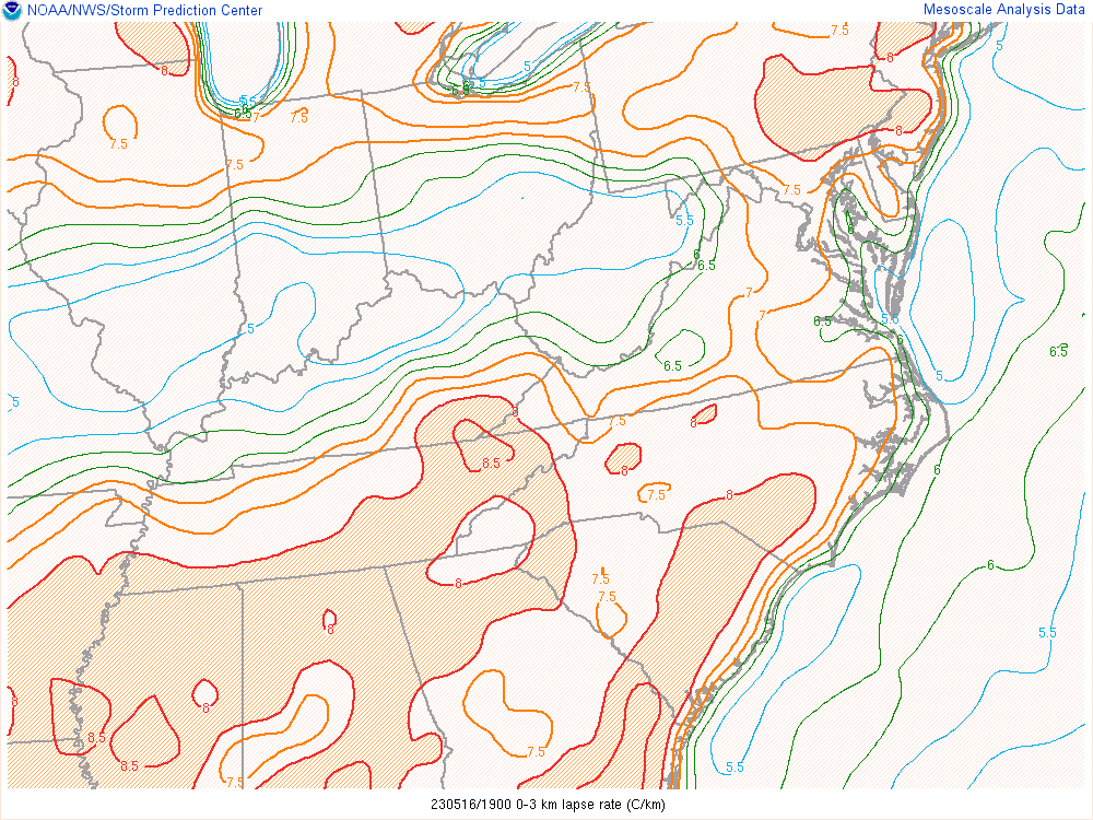
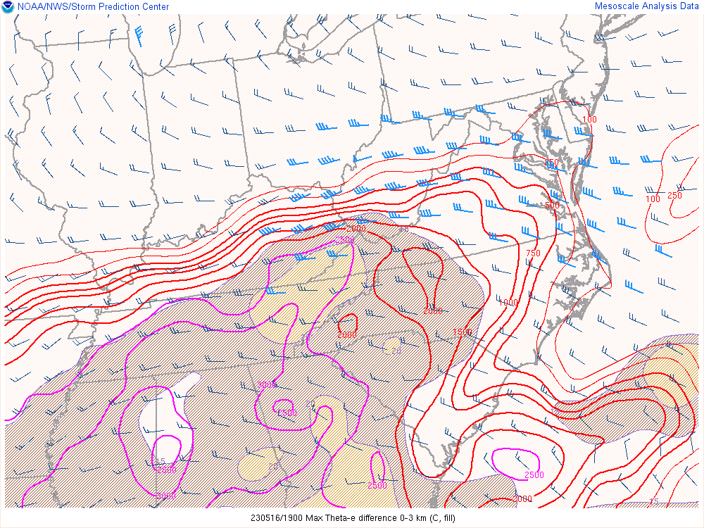
The sunshine in the warm sector also steepened the low-level lapse rates (Figure 9) to over 8.0 C/km between the surface and 3 km AGL. Lapse rates of this magnitude are indicative of the potential for strong downdrafts. Additionally, 0-3 km bulk wind shear (Figure 10) of around 30 knots is favorable for bowing thunderstorm line segments leading to damaging straight-line winds. Finally, the Derecho Composite (Figure 11), a parameter for identifying environments favorable for cold pool "driven" wind events, registered up to a 4 in far southeast Kentucky. This rather favorable environment encouraged storm segments to develop and begin surging to the east southeast. The intensifying bowing thunderstorm lines seem to have produced the strongest straight-line wind gusts in eastern Kentucky over northern Letcher, southern Pike, and also central Harlan counties before crossing into Southwest Virginia.
 |
 |
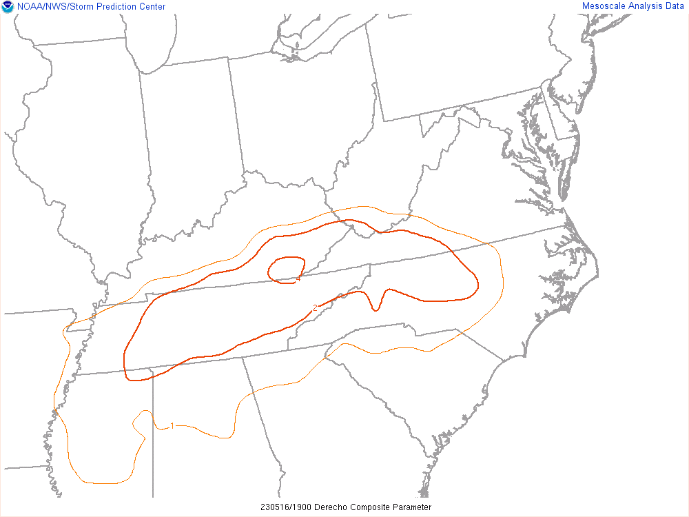 |
| Figure 9: Low-level Lapse Rates | Figure 10: Max 0-3 km Theta-e Difference | Figure 11: Derecho Composite |
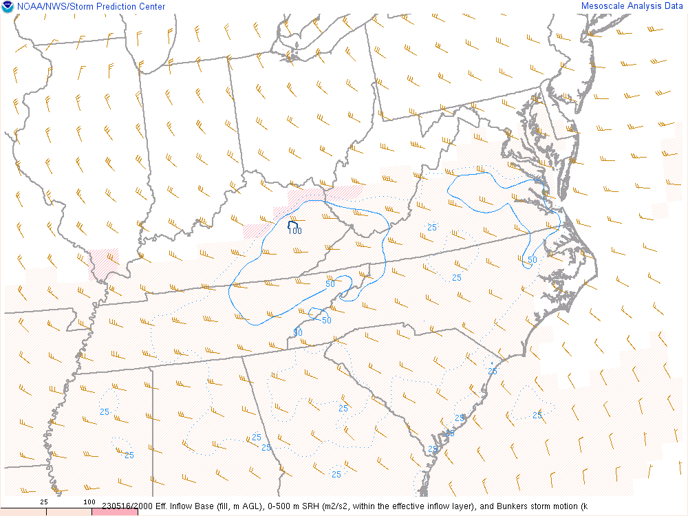
As previously mentioned, the environment, especially near the warm front was quite favorable for supercells. It is also in this area where the the greatest amount of turning (or Storm Relative Helicity) in the winds was analyzed between the surface and 500 m as shown in Figure 12. The 0-500m Storm Relative Helicity (SRH) is an effective discriminator between tornadic and non-tornadic supercells. In this case, a small pocket of elevated 0-500m SRH was analyzed to track along the boundary as low pressure rode along the warm front. Another parameter, the Significant Tornado Parameter (STP) in Figure 13, tries to account for several additional parameters including low-level stability and cloud base height in an effort to discriminate between environments that are favorable for strong tornadoes. A majority of strong tornadoes (EF-2+) have been associated with STP values greater than 1, while most non-tornadic supercells have occurred in environments with values less than 1. On this day, a small bubble of STP greater than 1 was analyzed over far eastern Kentucky and a tornado did occur, though it did fall short of an EF-2 rating.
 |
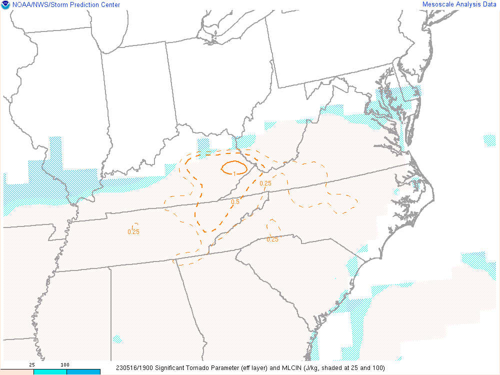 |
| Figure 12: 0-500m Storm Relative Helicity | Figure 13: Significant Tornado Parameter |
 |
Media use of NWS Web News Stories is encouraged! Please acknowledge the NWS as the source of any news information accessed from this site. |
|

