Overview
|
A slow-moving upper level shortwave trough advancing out of the Mississippi Valley and subtle waves of low pressure riding along an attendant surface cold front led to multiple rounds of stormy weather on July 2nd, 2023. Though shear was only marginally sufficient, plenty of strong early July sunshine over Kentucky (on the warm side of the front) led to a highly unstable environment which fueled rounds of intense and particularly photogenic thunderstorms. The first severe thunderstorms reached the Southeastern Bluegrass and Red River Gorge areas by around 5 PM with locally intense winds. The most substantial wind damage was reported in the Levee area of Montgomery County where multiple structures sustained wind damage and many trees were snapped. An official NWS Storm Survey determined that the winds were straight-line and not tornadic. Sizable power outages were also reported in Montgomery and Menifee counties with these storms. The first cluster of storms generally weakened as they crossed the Licking River basin and departed through the Big Sandy River basin. A second line of storm organized over Central Kentucky and moved into Eastern Kentucky around and after 8 PM. The strongest portions of the second line generally impacted locations to the south of the Mountain Parkway. Overall intensity of the thunderstorms diminished during the mid and late evening with the loss of heating and increasing low-level stability. By the time storms came to an end, the National Weather Service in Jackson had received more than 60 reports of severe weather, primarily in the form of wind damage. |
|
Photos
 |
 |
 |
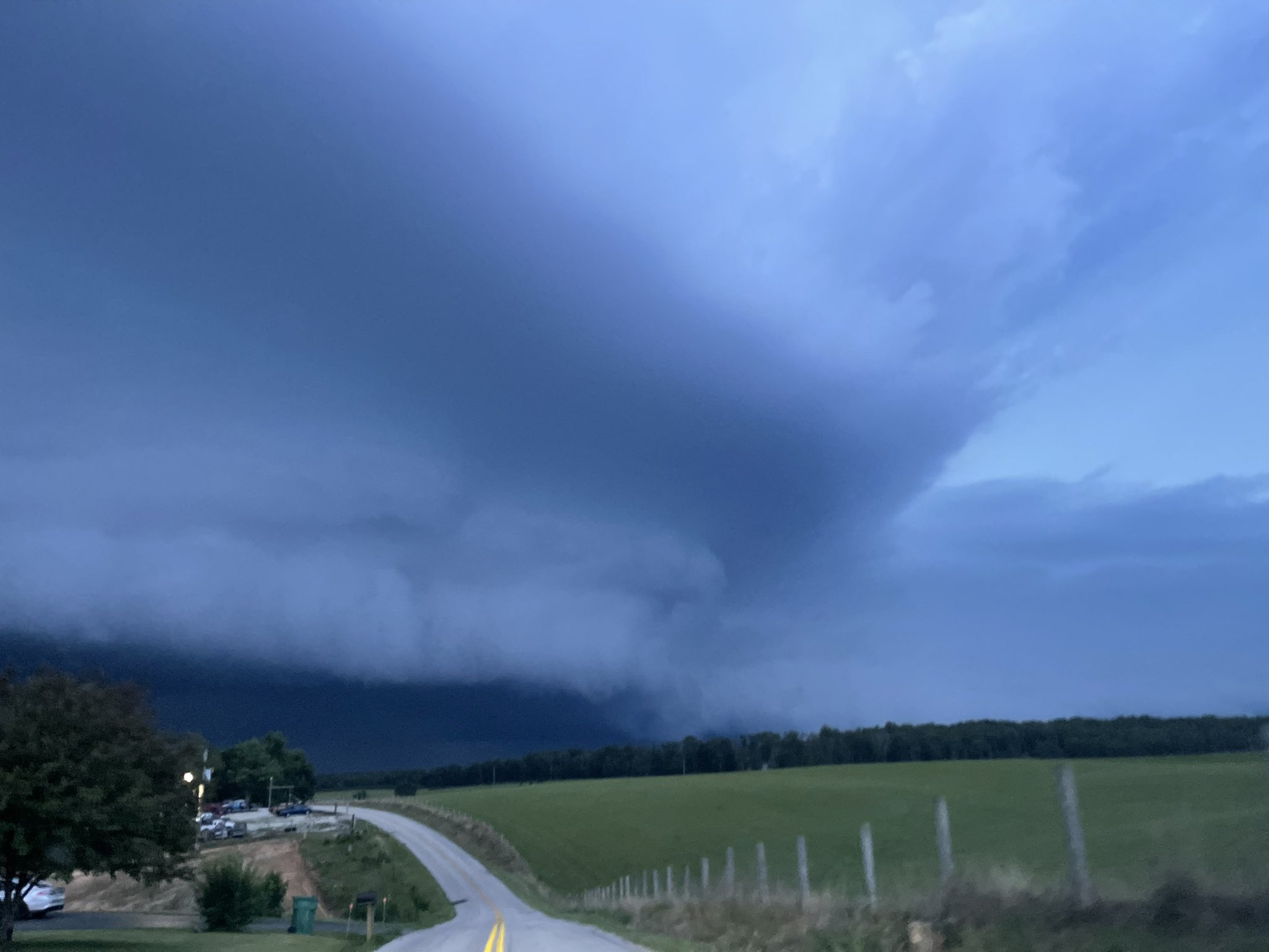
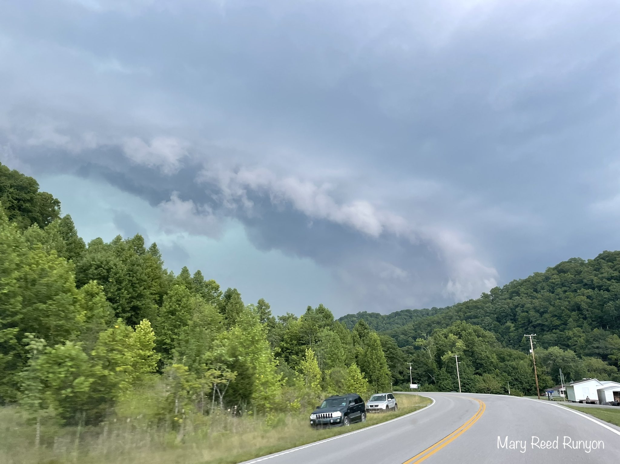
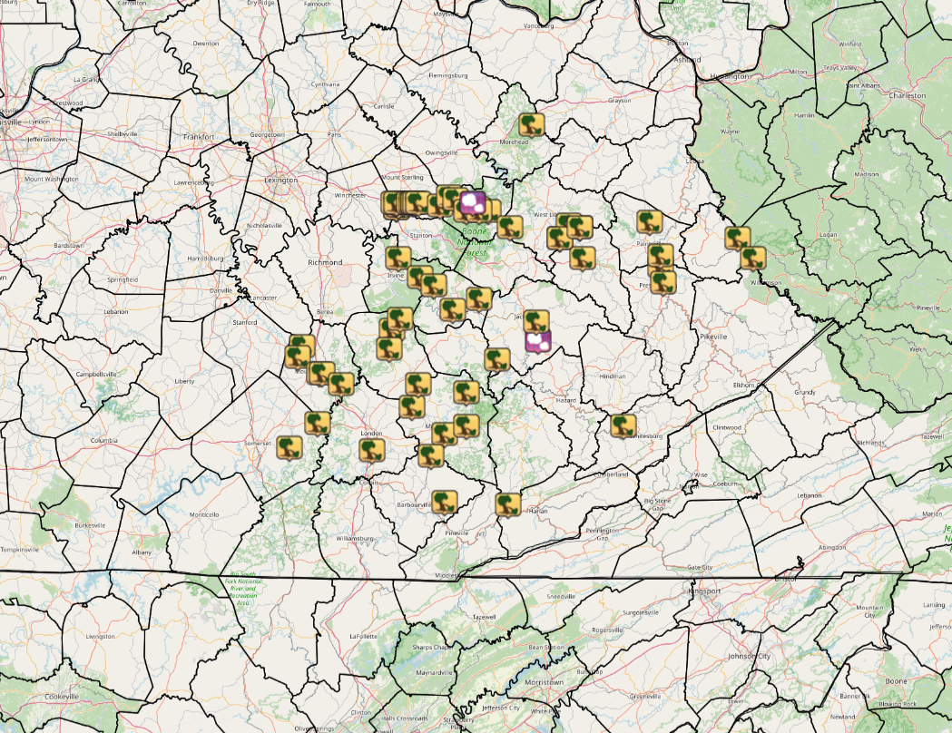
| Shelf Cloud Approaching the Tug Fork (Pike County) (Courtesy of Mary Reed Runyon) |
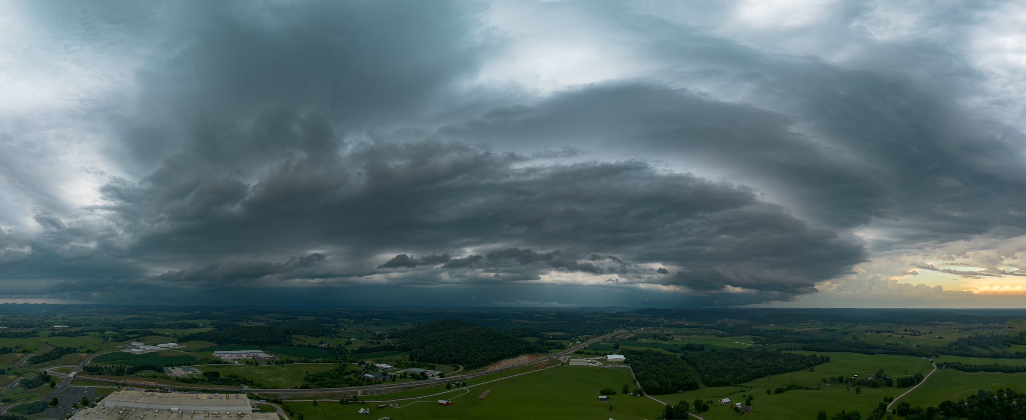
View of Thunderstorm (Rockcastle County) (Courtesy of Billy Bowling) |
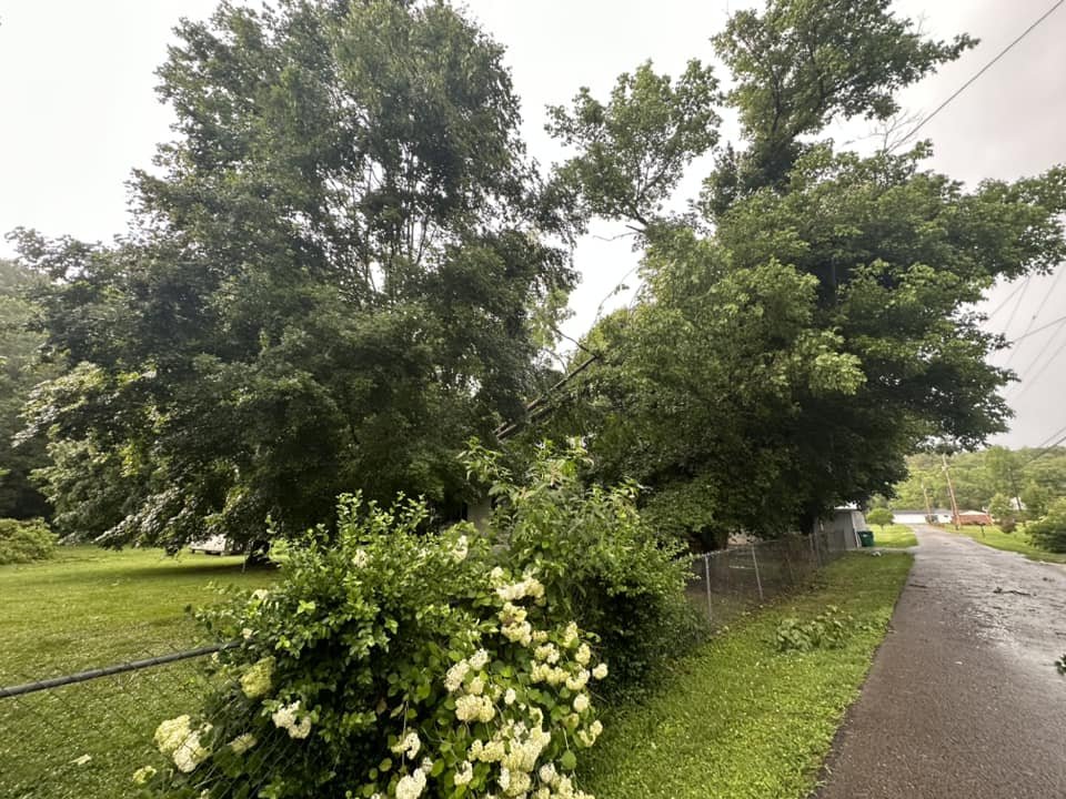
Wind Damage to Trees (Rowan County) (Courtesy of Joe Clark) |
 |
 |
 |
 |
| Damaged Porch near Levee (Montgomery County) (Courtesy of NWS Storm Survey Team) |
Thunderstorm near McKee (Jackson County) (Courtesy of Jessica Thorpe) |
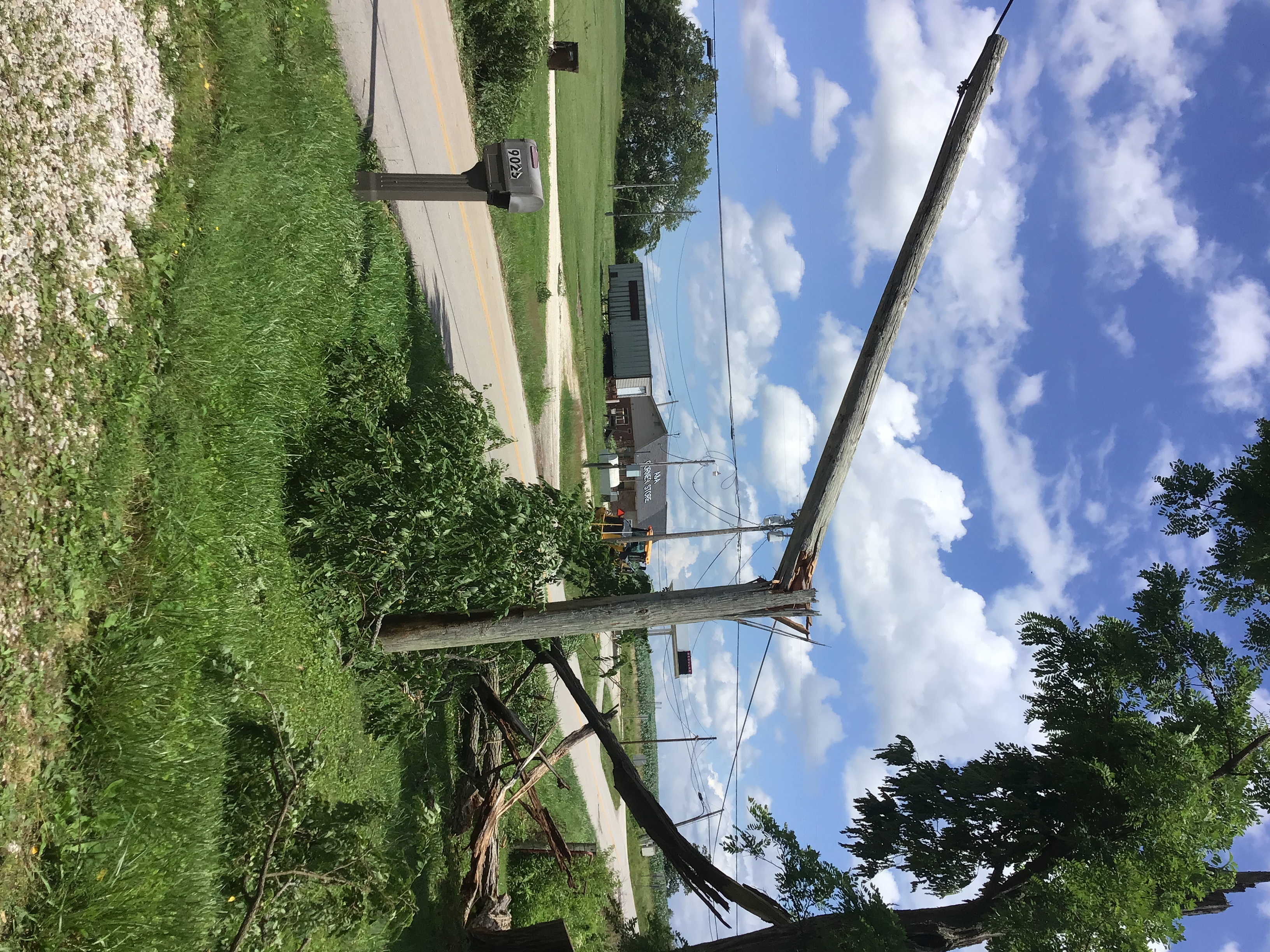
Snapped Power Pole near Levee (Montgomery County) (Courtesy of NWS Storm Survey Team) |
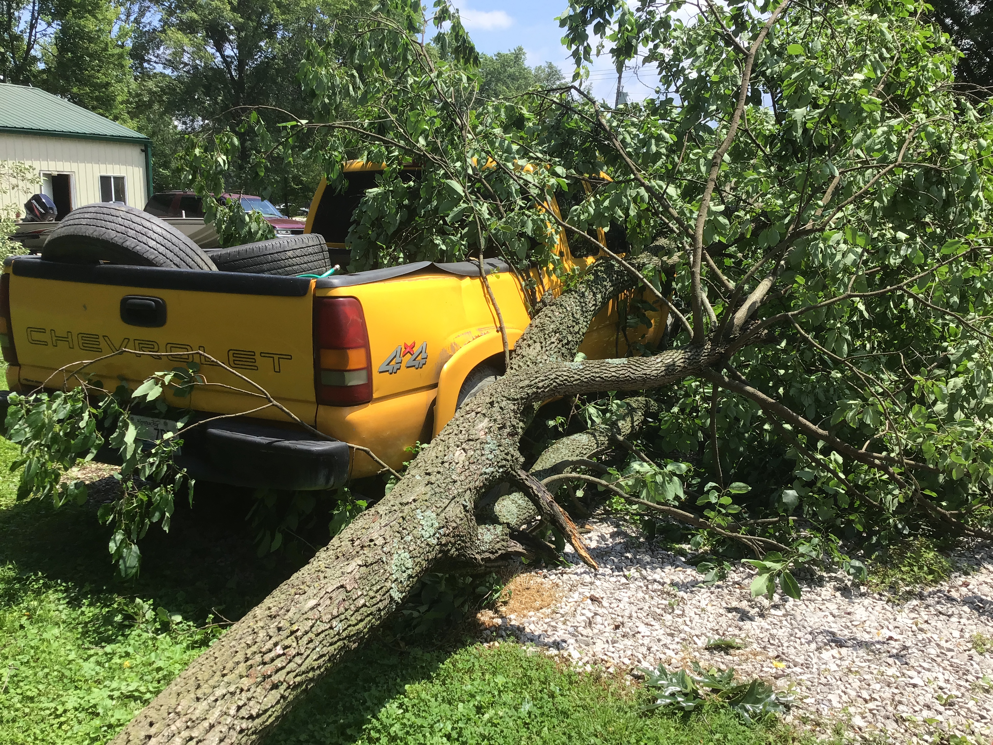
Tree Fallen on Truck (Montgomery County) (Courtesy of NWS Storm Survey Team) |
 |
.jpg) |
 |
 |
 |
| Partially Collapsed Barn near Levee (Montgomery County) (Courtesy of NWS Storm Survey Team) |
Roofing Material Strewn near Levee (Montgomery County) (Courtesy of NWS Storm Survey Team) |
Damaged Barn near Levee (Montgomery County) (Courtesy of NWS Storm Survey Team) |
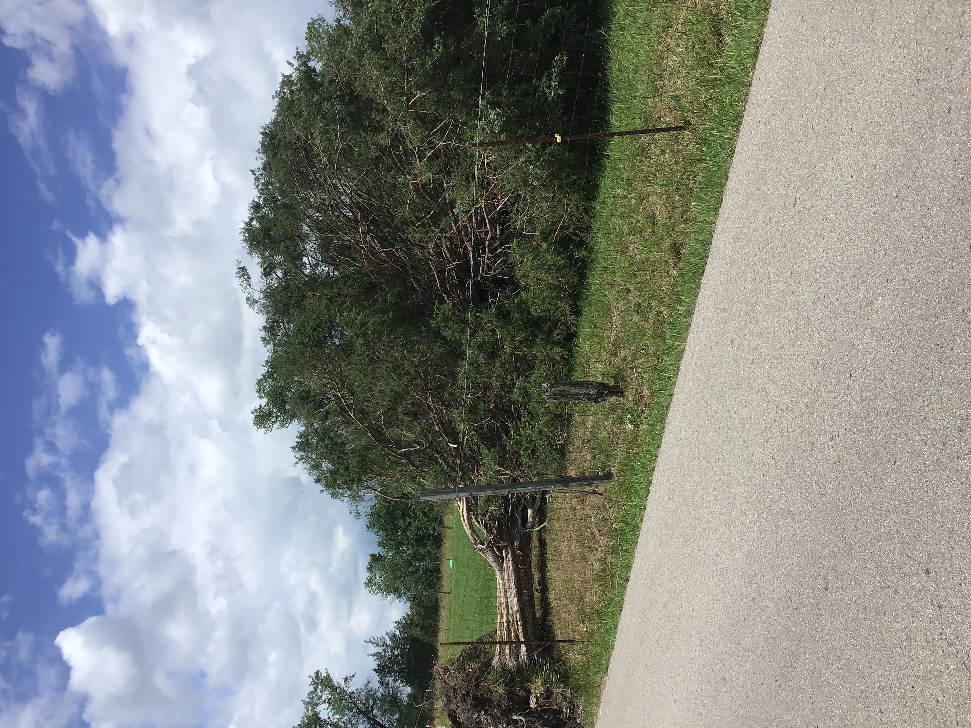
Large Tree Uprooted near Levee (Montgomery County) (Courtesy of NWS Storm Survey Team) |
Large Tree Snapped Beside Home near Levee (Montgomery County) (Courtesy of NWS Storm Survey Team) |
Storm Reports
 |
|
Storm Reports From July 2nd, 2023 |
..TIME...   ...EVENT...      ...CITY LOCATION...     ...LAT.LON...
..DATE...   ....MAG....      ..COUNTY LOCATION..ST.. ...SOURCE....
            ..REMARKS..

0506 PM     Tstm Wnd Dmg     2 N Westbend            37.94N 83.97W
07/02/2023                   Montgomery         KY   NWS Storm Survey

            Tree trunk partially snapped at a residence
            near the 2700 block of Orear Road.

0507 PM     Tstm Wnd Dmg     2 SW Levee              37.95N 83.96W
07/02/2023                   Montgomery         KY   NWS Storm Survey

            NWS survey team saw a partially rotten tree
            branch broken and laying along side of the
            road. Time estimated from radar.

0508 PM     Tstm Wnd Dmg     2 WSW Levee             37.96N 83.97W
07/02/2023                   Montgomery         KY   NWS Storm Survey

            NWS survey team saw a healthy uprooted oak
            tree along Nest Egg Road. Time estimated
            from radar.

0508 PM     Tstm Wnd Dmg     1 SSW Levee             37.96N 83.94W
07/02/2023                   Montgomery         KY   NWS Storm Survey

            NWS survey team saw multiple healthy trees
            snapped. Time estimated from radar.

0514 PM     Tstm Wnd Dmg     2 ESE Levee             37.96N 83.89W
07/02/2023                   Montgomery         KY   NWS Storm Survey

            NWS survey team saw a large tree trunk
            snapped and laying on a front porch,
            portions of a shed roof rolled up and a
            medium sized tree trunk snapped. Time
            estimated from radar.

0515 PM     Tstm Wnd Dmg     3 ESE Levee             37.96N 83.89W
07/02/2023                   Montgomery         KY   NWS Storm Survey

            NWS survey team saw multiple large tree
            branches blown near the 7200 block of
            Carmargo Levee Road . Time estimated from
            radar.

0515 PM     Tstm Wnd Dmg     3 S Camargo             37.96N 83.88W
07/02/2023                   Montgomery         KY   NWS Storm Survey

            NWS survey team saw multiple medium sized
            hardwood trees uprooted along the 300 block
            of Welch Road. Time estimated from radar.

0517 PM     Tstm Wnd Dmg     2 W Jeffersonville      37.96N 83.87W
07/02/2023                   Montgomery         KY   NWS Storm Survey

            NWS survey team saw a partial barn collapse
            with multiple pieces of roofing metal thrown
            in an adjacent field. Also, multiple large
            trees trunks were snapped at the property
            Time estimated from radar.

0523 PM     Tstm Wnd Dmg     1 NW Means              37.95N 83.77W
07/02/2023                   Menifee            KY   911 Call Center

            A tree was reported to be down near 377
            Whispering Pines Road blocking the roadway.
            The event time is radar estimated.

0527 PM     Tstm Wnd Dmg     2 NNW Cornwell          37.98N 83.73W
07/02/2023                   Menifee            KY   911 Call Center

            2 trees were reported to have been blown
            down blocking the road near 2224 East Fork
            Road Means, KY. The event time is radar
            estimated.

0530 PM     Tstm Wnd Dmg     1 NW Rothwell           37.97N 83.70W
07/02/2023                   Menifee            KY   911 Call Center

            A tree was reported to be down on a
            powerline near 107 Hidden Valley Spur Road.
            The event time is radar estimated.

0534 PM     Tstm Wnd Dmg     1 NE Tabor              37.93N 83.65W
07/02/2023                   Menifee            KY   911 Call Center

            A tree was reported to have been down onto a
            powerline on Amos Ridge Road just past Amos
            Cut Road. The event time is radar estimated.

0537 PM     Tstm Wnd Dmg     2 SE Frenchburg         37.94N 83.60W
07/02/2023                   Menifee            KY   911 Call Center

            A tree was reported to have been blown onto
            a powerline leading to the powerline being
            torn from the pole. The event time is radar
            estimated.

0537 PM     Tstm Wnd Dmg     1 NW Denniston          37.93N 83.55W
07/02/2023                   Menifee            KY   911 Call Center

            A tree was reported to have been blown onto
            an electric line leading to a fire near 454
            Mortbotts Road.

0540 PM     Hail             Frenchburg              37.96N 83.62W
07/02/2023  E1.00 inch       Menifee            KY   Emergency Mngr

            County EM reported quarter size hail
            starting at the intersection of 460 and
            KY-36 and running northeast to the
            intersection of KY-36 and Old Beaver Rd.

0540 PM     Tstm Wnd Dmg     1 NW Mariba             37.93N 83.59W
07/02/2023                   Menifee            KY   911 Call Center

            A tree was reported to be have been down
            onto the roadway along Pear Tree Way near
            Frenchburg. The event time is radar
            estimated.

0600 PM     Tstm Wnd Dmg     1 ENE Gates             38.24N 83.35W
07/02/2023                   Rowan              KY   Emergency Mngr

            Images of a tree over powerlines and a house
            on Castle Drive. 911 call center reported
            the tree over the powerlines later caught
            fire. Power was turned off for around 1000
            customers, while the tree was removed and
            powerlines were operated on. Power since
            restored. Time estimated by radar.

0612 PM     Tstm Wnd Dmg     1 S Florress            37.88N 83.18W
07/02/2023                   Morgan             KY   911 Call Center

            911 call center had reports of trees down at
            the intersection of Lacy Creek Rd and
            Highway 364. Time estimated by radar.

0620 PM     Tstm Wnd Dmg     Gifford                 37.76N 83.12W
07/02/2023                   Magoffin           KY   911 Call Center

            911 call center had a report of a tree down
            at the end of Gifford Rd at 460 N. Time
            estimated by radar.

0635 PM     Tstm Wnd Dmg     Foxtown                 37.50N 83.99W
07/02/2023                   Jackson            KY   911 Call Center

            Several trees were blown down near 200 Moore
            Ridge Road in the Foxtown Community. The
            event time is radar estimated.

0638 PM     Tstm Wnd Dmg     Galen                   37.89N 82.81W
07/02/2023                   Johnson            KY   Utility Company

            Trees were blown onto powerlines in the
            Stambaugh vicinity per a post to social
            media. The event time is radar estimated.

0644 PM     Tstm Wnd Dmg     2 NNW Wind Cave         37.54N 83.95W
07/02/2023                   Jackson            KY   911 Call Center

            Trees down near 2000 Salt Rock Road.

0648 PM     Tstm Wnd Dmg     1 ENE Bays Branch       37.73N 82.76W
07/02/2023                   Floyd              KY   911 Call Center

            A tree was blown into a powerline. The even
            time is radar estimated.

0652 PM     Tstm Wnd Dmg     Van Lear                37.77N 82.76W
07/02/2023                   Johnson            KY   Emergency Mngr

            Trees were blown down onto a powerline
            leading to a fire in Van Lear.

0655 PM     Tstm Wnd Dmg     1 E Prestonsburg        37.67N 82.75W
07/02/2023                   Floyd              KY   911 Call Center

            Multiple trees and large limbs down on Lake
            Drive. The event time is radar estimated.

0717 PM     Tstm Wnd Dmg     1 ESE Warfield          37.83N 82.41W
07/02/2023                   Martin             KY   Public

            Trees down onto KY 292 in the Warfield to
            Lovely area. The event time is radar
            estimated.

0724 PM     Tstm Wnd Dmg     3 NNE Whitepost         37.76N 82.34W
07/02/2023                   Martin             KY   Dept of Highways

            Trees and limbs were reported to have been
            down in multiple locations along KY 292 from
            near Warfield to the Pike County line. The
            event time is radar estimated.

0740 PM     Hail             1 W Clayhole            37.46N 83.32W
07/02/2023  E0.75 inch       Breathitt          KY   Public

            Report from mPING: Dime (0.75 in.).

0815 PM     Tstm Wnd Dmg     2 NW Hiatt              37.44N 84.40W
07/02/2023                   Rockcastle         KY   Public

            A tree was down on Chestnut Grove Road in
            the Chestnut Grover Community. The event
            time is radar estimated.

0815 PM     Tstm Wnd Dmg     2 SW Hardwick           37.76N 83.96W
07/02/2023                   Estill             KY   911 Call Center

            Tree reported down over Eades Drive from the
            911 call center. Time estimated by radar.

0818 PM     Tstm Wnd Dmg     Brodhead                37.40N 84.42W
07/02/2023                   Rockcastle         KY   Public

            A tree was blown down in Brodhead. The event
            time is radar estimated.

0829 PM     Tstm Wnd Dmg     2 SE Pitts              37.69N 83.86W
07/02/2023                   Estill             KY   Public

            A tree was reported down on Tipton Ridge
            Road. The event time is radar estimated.

0840 PM     Tstm Wnd Dmg     1 W Burr                37.34N 84.32W
07/02/2023                   Rockcastle         KY   Public

            A tree was down on Chestnut Ridge Road near
            the southside of Mount Vernon. The event
            time is radar estimated.

0840 PM     Tstm Wnd Dmg     2 NNE Maytown           37.87N 83.45W
07/02/2023                   Morgan             KY   911 Call Center

            Tree reported down over Highway 1010 near
            mile marker 2. This would have been near the
            intersection of Blackwater Rd. Time
            estimated by radar.

0841 PM     Tstm Wnd Dmg     Burr                    37.34N 84.31W
07/02/2023                   Rockcastle         KY   Public

            A tree was blown down on Big Cave Road. The
            even time is radar estimated.

0846 PM     Tstm Wnd Dmg     Livingston              37.30N 84.22W
07/02/2023                   Rockcastle         KY   Public

            A tree was blown down on South Wilderness
            Road. The event time is radar estimated.

0850 PM     Tstm Wnd Dmg     Beattyville             37.57N 83.71W
07/02/2023                   Lee                KY   Dept of Highways

            Highway garage reported a tree down over
            Highway 11 near mile marker 5. Time
            estimated by radar.

0850 PM     Tstm Wnd Dmg     1 NW Whynot             37.66N 83.80W
07/02/2023                   Lee                KY   Dept of Highways

            Highway garage reported a tree down on
            KY-1746 near 52. Time estimated by radar.

0905 PM     Tstm Wnd Dmg     1 ENE Lewis             37.83N 83.22W
07/02/2023                   Morgan             KY   911 Call Center

            Tree reported down half way along KY 1162.
            Time estimated by radar.

0905 PM     Tstm Wnd Dmg     1 ENE Primrose          37.61N 83.59W
07/02/2023                   Lee                KY   911 Call Center

            911 call center reported a tree down over
            Blankey Branch road. Time estimated by
            radar.

0906 PM     Tstm Wnd Dmg     Mckee                   37.43N 84.00W
07/02/2023                   Jackson            KY   Public

            A tree was blown down near 200 Highway KY
            290.

0910 PM     Tstm Wnd Dmg     1 WSW Logville          37.87N 83.13W
07/02/2023                   Morgan             KY   911 Call Center

            Tree reported down over Highway 364 just
            prior to the intersection of Trace Fork Rd
            heading eastbound. Time estimated by radar.

0942 PM     Tstm Wnd Dmg     1 W Portsmouth          37.53N 83.33W
07/02/2023                   Breathitt          KY   Law Enforcement

            A tree was reported to have been down on KY
            1098 about 2 miles from KY 15.

1031 PM     Tstm Wnd Dmg     1 SSW Jeremiah          37.15N 82.93W
07/02/2023                   Letcher            KY   Public

            A tree was blown down along KY 7 near the
            Letcher Elementary and Middle School. The
            event time is radar estimated.

1038 PM     Tstm Wnd Dmg     Grade                   37.07N 84.46W
07/02/2023                   Pulaski            KY   911 Call Center

            A tree was blown on Malvin Hill Church Road
            near KY 80. The event time is radar
            estimated.

1049 PM     Tstm Wnd Dmg     Garrard                 37.12N 83.75W
07/02/2023                   Clay               KY   911 Call Center

            A tree was blown down on KY 11 in the
            Garrard area near Manchester. The event time
            is radar estimated.

1052 PM     Tstm Wnd Dmg     2 WSW Billows           37.16N 84.33W
07/02/2023                   Pulaski            KY   911 Call Center

            A tree was blown down on Sandy Gap near the
            intersection with KY 80. The event time is
            radar estimated.

1057 PM     Tstm Wnd Dmg     2 WSW Fariston          37.06N 84.08W
07/02/2023                   Laurel             KY   Public

            A large tree limb was reported to be down
            near 200 Riverbend Road. The event time is
            radar estimated.

1122 PM     Tstm Wnd Dmg     1 NNE Woollum           37.04N 83.81W
07/02/2023                   Clay               KY   911 Call Center

            A tree was reported to be down near 8000 KY
            11 South. The event time is radar estimated.

1123 PM     Tstm Wnd Dmg     Fogertown               37.22N 83.90W
07/02/2023                   Clay               KY   911 Call Center

            A tree was reported down on KY 472 in the
            Fogertown community.

1130 PM     Tstm Wnd Dmg     1 NNW Shepherdtown      37.30N 83.87W
07/02/2023                   Clay               KY   911 Call Center

            A tree was down along US 421 near the Clay
            and Jackson County line near Shepherdtown.

1135 PM     Tstm Wnd Dmg     Hector                  37.15N 83.65W
07/02/2023                   Clay               KY   911 Call Center

            A tree was blown down onto KY 149 near
            Hector. The event time is radar estimated.

1136 PM     Tstm Wnd Dmg     1 SW Dewitt             36.87N 83.75W
07/02/2023                   Knox               KY   911 Call Center

            2 trees were blown down along KY 223 near
            Escoes Market with one onto a powerline
            causing a fire. The event time is radar
            estimated.

1140 PM     Tstm Wnd Dmg     Oneida                  37.27N 83.65W
07/02/2023                   Clay               KY   Public

            A tree was reported to have been blown down
            on 1st Street.

1156 PM     Tstm Wnd Dmg     1 NE Morris Fork        37.39N 83.51W
07/02/2023                   Breathitt          KY   Public

1159 PM     Tstm Wnd Dmg     1 NE Tacky Town         36.86N 83.46W
07/02/2023                   Harlan             KY   911 Call Center

            Trees were reported to have been blown down
            near the intersection of KY 1780 and KY 221
            that had been received by the Leslie County
            Dispatch but occurred in Harlan County. The
            event time is radar estimated.
Environment
The surface analysis (Figure 1) showed multiple weak waves of low pressure tracking along a cold front making painfully slow progress into the Lower Ohio Valley. On the warm side of the front, multiple clusters of thunderstorms developed and initiated multiple outflow boundaries which moved toward the Appalachians and disintegrated.
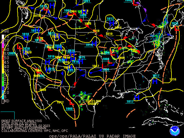 |
| Figure 1: Surface Analysis from 2AM (0600Z) July 2nd until 2 AM (0600Z) LT July 3rd, 2023 |
 |
 |
 |
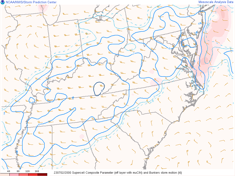 |
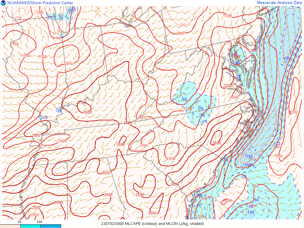
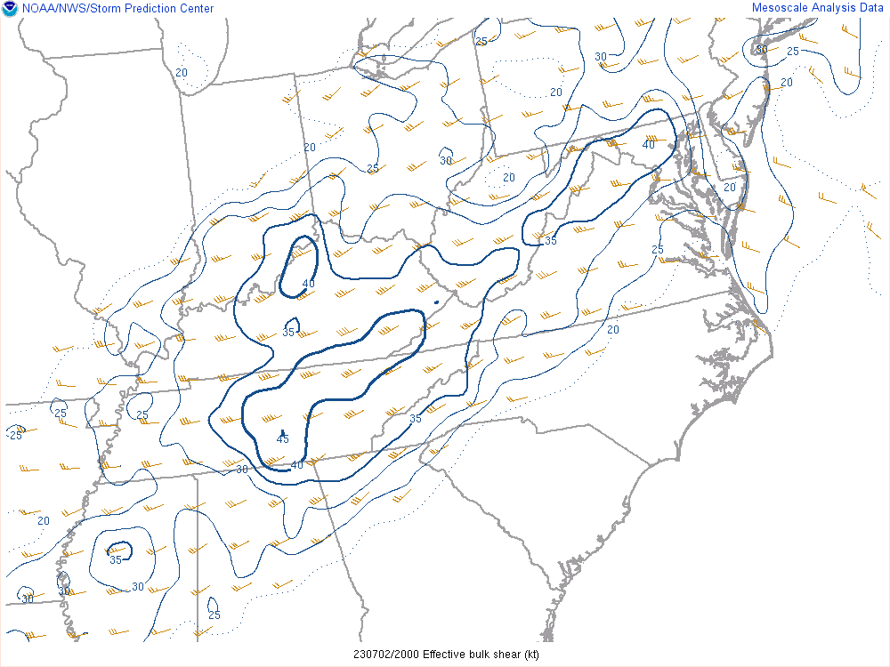
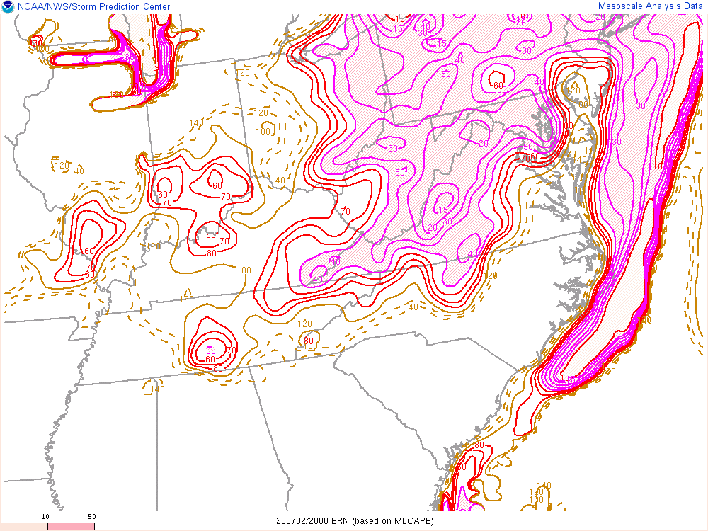
| Figure 2: MLCAPE (J/kg) | Figure 3: Effective Shear (kts) | Figure 4: Bulk Richardson Number | Figure 5: Supercell Composite |
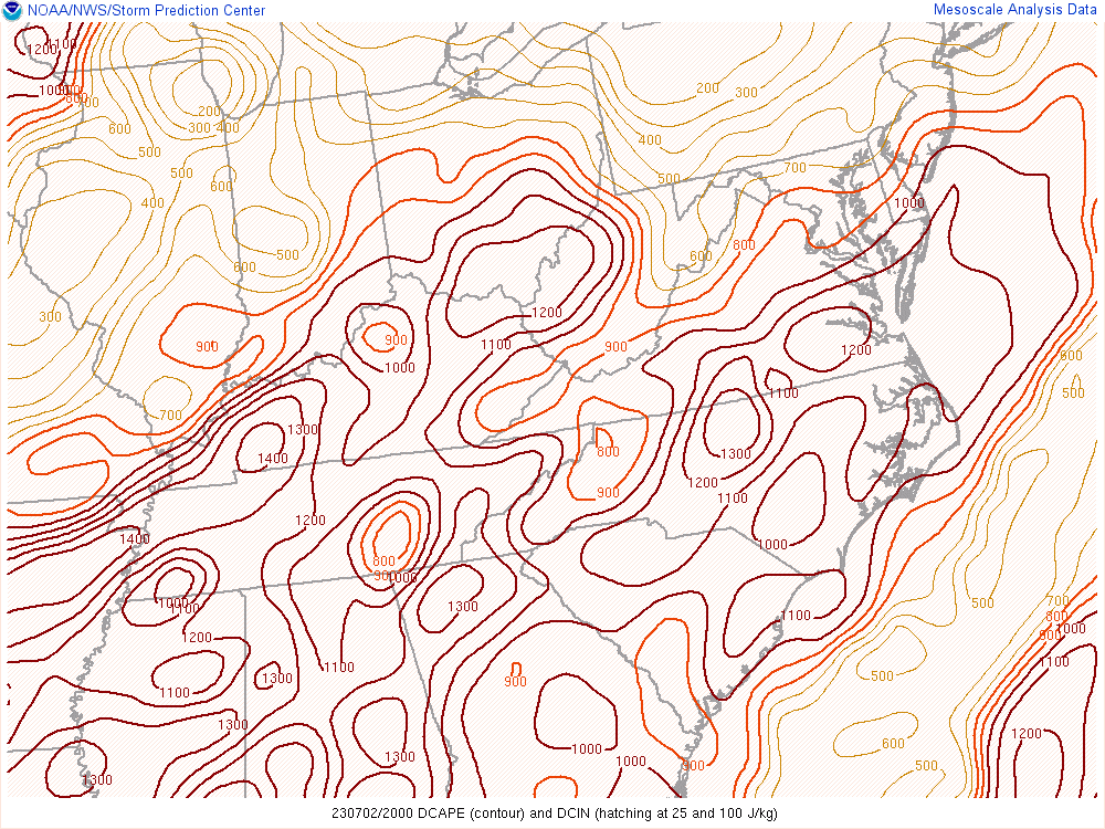
The primary threat with the storms turned out to be wind. Dry air aloft, evidenced by DCAPE (Figure 6) values largely in excess of 900 J/kg, was supportive of the generation of strong rain-cooled downdrafts. Fairly steep low-level lapse rates (Figure 7) favored those downdrafts reaching the surface and leading to damaging wind gusts. Thus it is not surprising that dozens of instances of wind damage were reported across eastern Kentucky.
 |
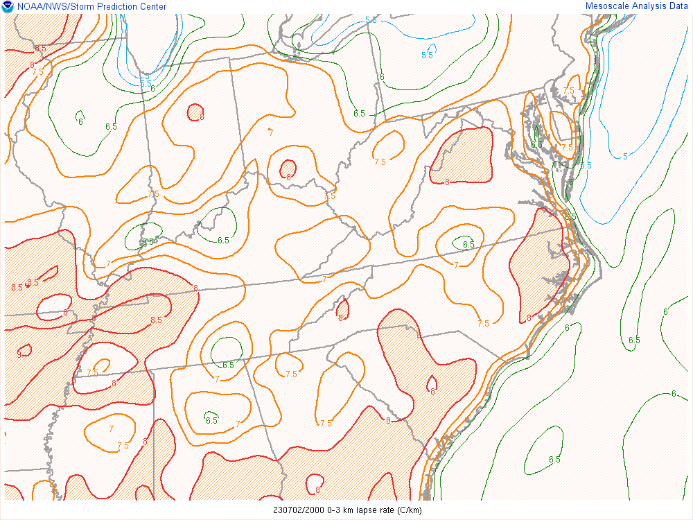 |
| Figure 6: DCAPE (J/kg) | Figure 7: Surface-3km AGL Lapse Rates (ºC/km) |
 |
Media use of NWS Web News Stories is encouraged! Please acknowledge the NWS as the source of any news information accessed from this site. |
|