Record-Breaking Arctic Airmass Brings Late-Season Freeze Across Eastern Kentucky on May 9-10th, 2020
Overview
A late-season push of Arctic air brought a freeze and record-breaking cold temperatures across eastern Kentucky May 9-10th. The Jackson National Weather Service Office, on top of Sugar Camp Mountain, dropped to 30 degrees on the morning of the 9th, setting an all-time record low temperature for the month of May. Jackson then fell to 36 degrees on the morning of the 10th, setting a new daily record low. Record cool daily maximum temperatures of 54 degrees were also set at the Jackson office on both the 8th and 9th. Many valley locations saw temperatures falling to near or below 30 degrees on the morning of the 9th. Temperatures were overall slightly warmer on the morning of the 10th, but still dropped to between 29 and 32 degrees in many sheltered valley locations. The first night generally featured the coldest sub-freezing temperatures, but the lateness of the frontal passage on the evening of the 8th kept the coldest air from settling over the area for more than a few hours, possibly resulting in a less damaging freeze than what would have typically occurred with cold temperatures of this magnitude. That being said, impacts were still felt, especially in terms of horticulture. Apples were taken out in Rowan County, while Pulaski County had about all of their peaches frozen out. Pears and winter wheat were also damaged across eastern Kentucky.
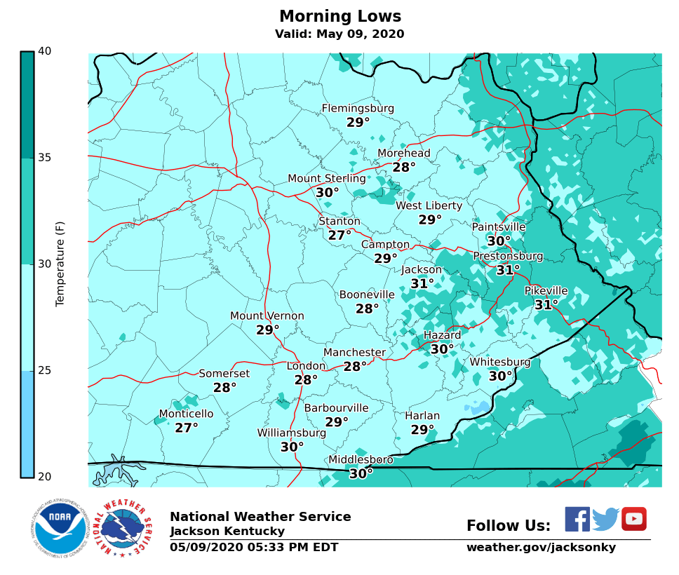
May 9th
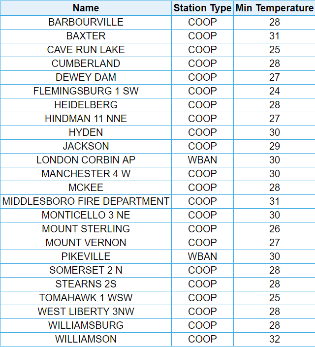
A strong cold front pushed through eastern Kentucky late in the evening on May 8th. Behind that front, a late-season push of dry Arctic air brought a freeze and record-breaking cold temperatures across eastern Kentucky on the morning of May 9th. The Jackson National Weather Service Office dropped to 30 degrees, setting an all-time record low temperature for the month of May. The previous record was 32 degrees set in 1989 and tied in 1997 and 2004. Jackson also broke the daily record of 35 degrees set in 1983. The other long-standing eastern Kentucky NWS weather recording site at the London-Corbin Airport plummeted to 28 degrees, tying the previous all-time record low temperature for the Month of May set in 1963. London also broke the daily record low of 33 set in 1976. Elsewhere across eastern Kentucky, most experienced temperatures in the upper 20s to lower 30s. A few of the higher elevation locations were even colder, including Black Mountain (elevation 4,031 ft.) and Dorton (elevation 2,774 ft.) with lows of 21 and 26 degrees, respectively.
...LOW TEMPERATURE REPORTS...

Location                     Temp      Time/Date       Provider
Harlan 24 E                   21 F     0705 AM 05/09   KYMN2
Corbin                        25 F     0657 AM 05/09   CWOP
Pikeville 13 S                26 F     0745 AM 05/09   KYMN2
Monticello Apt                26 F     0556 AM 05/09   ASOS
3 SSE Whitesburg              27 F     0745 AM 05/09   KYTC-RWIS
McKee 5 S                     27 F     0715 AM 05/09   KYMN2
Irvine                        27 F     0700 AM 05/09   CWOP
3 NW West Liberty             27 F     0700 AM 05/09   AWS
Stanton 2 W                   27 F     0700 AM 05/09   COOP
Somerset 7 NNE                27 F     0635 AM 05/09   KYMN2
3 N Farmers                   27 F     0615 AM 05/09   KYTC-RWIS
Cressy (coop)                 28 F     0800 AM 05/09   UCOOP
Booneville 2 S                28 F     0725 AM 05/09   KYMN2
Williamsburg                  28 F     0715 AM 05/09   AWOS
Whitley City 3 N              28 F     0715 AM 05/09   KYMN2
Williamsburg                  28 F     0712 AM 05/09   CWOP
Koomer Ridge                  28 F     0709 AM 05/09   RAWS
1 WSW Mt Vernon               28 F     0709 AM 05/09   AWS
Morehead 4 NE                 28 F     0705 AM 05/09   KYMN2
1 WNW Koomer Rdg              28 F     0700 AM 05/09   KYTC-RWIS
Mount Sterling                28 F     0700 AM 05/09   COOP
Somerset Apt                  28 F     0655 AM 05/09   AWOS
London-corbin Apt             28 F     0653 AM 05/09   ASOS
Mt Sterling                   28 F     0416 AM 05/09   CWOP
Beattyville 4n (coop)         29 F     0900 AM 05/09   COOP
2 NW London                   29 F     0720 AM 05/09   KYTC-RWIS
Hindman 5 N                   29 F     0715 AM 05/09   KYMN2
Harlan Apt                    29 F     0715 AM 05/09   AWOS
Barbourville 3 E              29 F     0710 AM 05/09   KYMN2
Triangle Mtn Raws             29 F     0702 AM 05/09   RAWS
Peabody                       29 F     0701 AM 05/09   RAWS
West Liberty 2 SW             29 F     0625 AM 05/09   KYMN2
Owingsville 4 S               29 F     0605 AM 05/09   KYMN2
Somerset Raws                 29 F     0601 AM 05/09   RAWS
Oneida                        30 F     0935 AM 05/09   COOP
Manchester                    30 F     0737 AM 05/09   CWOP
1.6 E Middlesboro             30 F     0726 AM 05/09   HADS
I-75 @ KY-770 (Laurel)        30 F     0720 AM 05/09   KYTC-RWIS
Paintsville 4 W               30 F     0720 AM 05/09   KYMN2
Morehead Airport              30 F     0715 AM 05/09   AWOS
2 NNE Jellico (road)          30 F     0705 AM 05/09   KYTC-RWIS
Somerset Pulaski County       30 F     0701 AM 05/09   HADS
Inez 2e (coop)                30 F     0700 AM 05/09   COOP
Paintsville 1e (coop)         30 F     0700 AM 05/09   COOP
2 SE Whitesburg (coop)        30 F     0700 AM 05/09   COOP
Middlesboro Apt               30 F     0655 AM 05/09   AWOS
Nws Jackson                   30 F     0653 AM 05/09   ASOS
Jackson 3 SE                  30 F     0640 AM 05/09   KYMN2
Mount Sterling Apt            30 F     0635 AM 05/09   AWOS
1.6 S Rodburn                 30 F     0602 AM 05/09   HADS
Whitesburg 2 NW               31 F     0735 AM 05/09   KYMN2
Jackson Apt Raws              31 F     0715 AM 05/09   RAWS
Pike County Apt               31 F     0715 AM 05/09   AWOS
Middlesboro                   31 F     0700 AM 05/09   CWOP
Buckhorn Lake (coop)          31 F     0700 AM 05/09   COOP
Prestonsburg 3 WSW            31 F     0700 AM 05/09   COOP
Big Sandy Apt                 31 F     0655 AM 05/09   AWOS
1 NW Burnside                 31 F     0650 AM 05/09   KYTC-RWIS
Big Sandy Raws                31 F     0609 AM 05/09   RAWS

Observations are collected from a variety of sources with varying
equipment and exposures. We thank all volunteer weather observers
for their dedication. Not all data listed are considered official.
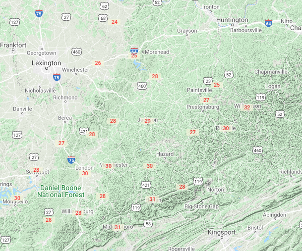
May 10th
The intense May sun quickly moderated the anomalously cold airmass during the afternoon of the 9th. However, the airmass was still cool and dry enough for one more night of sub-freezing temperatures across much of Eastern Kentucky. The Jackson National Weather Service Office, located on a thermal belt ridge, dropped to a daily record low of 36 degrees, breaking the previous daily record low of 38 degrees set in 2010. Meanwhile, the London-Corbin Airport dipped to 33 degrees, falling 3 degrees short of the 30 degree daily record set in 1966. Many of the sheltered valleys saw temperatures dipping to between 29 and 32 degrees.
.geertson.png)
...LOW TEMPERATURE REPORTS...

Location                     Temp      Time/Date       Provider
2 SE Whitesburg (coop)        29 F     0700 AM 05/10   COOP
Salyersville                  30 F     0800 AM 05/10   COOP
3 NW West Liberty             30 F     0735 AM 05/10   AWS
West Liberty 2 SW             30 F     0715 AM 05/10   KYMN2
Paintsville 4 W               30 F     0635 AM 05/10   KYMN2
Yellow Creek Raws             30 F     0626 AM 05/10   RAWS
1.6 E Middlesboro             31 F     0726 AM 05/10   HADS
Jackson 3 SE                  31 F     0725 AM 05/10   KYMN2
Whitesburg 2 NW               31 F     0720 AM 05/10   KYMN2
Booneville 2 S                31 F     0720 AM 05/10   KYMN2
Owingsville 4 S               31 F     0720 AM 05/10   KYMN2
Barbourville 3 E              31 F     0710 AM 05/10   KYMN2
Manchester                    31 F     0647 AM 05/10   CWOP
Harlan Apt                    31 F     0635 AM 05/10   AWOS
Middlesboro Apt               31 F     0635 AM 05/10   AWOS
McKee 5 S                     31 F     0610 AM 05/10   KYMN2
Beattyville 4n (coop)         32 F     0900 AM 05/10   COOP
Middlesboro                   32 F     0716 AM 05/10   CWOP
Williamsburg                  32 F     0715 AM 05/10   AWOS
Morehead 4 NE                 32 F     0715 AM 05/10   KYMN2
2 NNE Jellico (road)          32 F     0710 AM 05/10   KYTC-RWIS
Cherry Tree Knob              32 F     0701 AM 05/10   HADS
Peabody                       32 F     0701 AM 05/10   RAWS
Irvine                        32 F     0630 AM 05/10   CWOP
Harlan 24 E                   32 F     0625 AM 05/10   KYMN2
Mt Sterling                   32 F     0600 AM 05/10   CWOP
Buckhorn Lake (coop)          33 F     0700 AM 05/10   COOP
3 N Farmers                   33 F     0510 AM 05/10   KYTC-RWIS
Somerset Apt                  34 F     0715 AM 05/10   AWOS
I-75 @ KY-770 (Laurel)        34 F     0635 AM 05/10   KYTC-RWIS
Whitley City 3 N              34 F     0600 AM 05/10   KYMN2
Monticello Apt                34 F     0556 AM 05/10   ASOS
Mount Sterling Apt            34 F     0555 AM 05/10   AWOS
London-corbin Apt             34 F     0553 AM 05/10   ASOS
Williamsburg                  35 F     0807 AM 05/10   CWOP
Somerset 7 NNE                35 F     0715 AM 05/10   KYMN2
Koomer Ridge                  35 F     0709 AM 05/10   RAWS
3 SSE Whitesburg              35 F     0705 AM 05/10   KYTC-RWIS
2 NW London                   35 F     0705 AM 05/10   KYTC-RWIS
1 WNW Koomer Rdg              35 F     0700 AM 05/10   KYTC-RWIS
Hindman 5 N                   35 F     0655 AM 05/10   KYMN2
1 WSW Mt Vernon               35 F     0444 AM 05/10   AWS
NWS Jackson                   36 F     0800 AM 05/10   ASOS
Pike County Apt               36 F     0715 AM 05/10   AWOS
Jackson Apt Raws              36 F     0715 AM 05/10   RAWS
Somerset Raws                 36 F     0701 AM 05/10   RAWS
Morehead Airport              36 F     0655 AM 05/10   AWOS
Somerset                      37 F     0715 AM 05/10   CWOP
Big Sandy Apt                 37 F     0635 AM 05/10   AWOS
Big Sandy Raws                37 F     0609 AM 05/10   RAWS
Pikeville 13 S                37 F     0605 AM 05/10   KYMN2
1 NW Burnside                 39 F     0710 AM 05/10   KYTC-RWIS
1.6 S Rodburn                 40 F     0702 AM 05/10   HADS

Observations are collected from a variety of sources with varying
equipment and exposures. We thank all volunteer weather observers
for their dedication. Not all data listed are considered official.
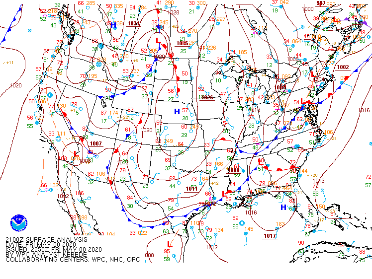
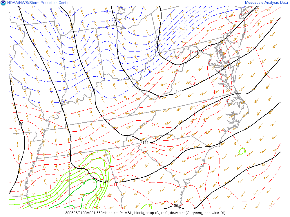
Environment and Historical Context
 |
 |
| 5 pm Friday, May 8th - 5 pm Saturday, May 9th | 5 pm Friday, May 8th - 5 pm Saturday, May 9th |
The Last Time Eastern Kentucky Saw Temperatures This Cold This Late in the Season was May 10, 1966.
 |
Media use of NWS Web News Stories is encouraged! Please acknowledge the NWS as the source of any news information accessed from this site. |
|

