Jackson, KY
Weather Forecast Office
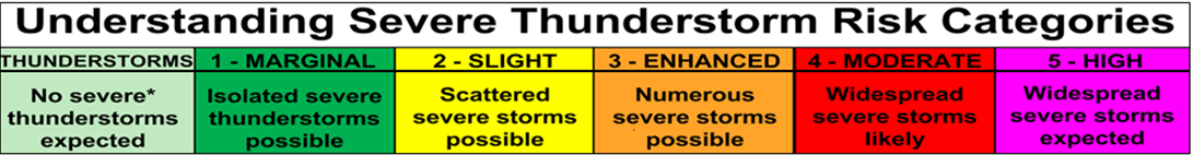
| Day 1 Convective Outlook | Day 2 Convective Outlook |
 |
 |
 |
|
 |
 |
 |
 |
||
525
FLUS43 KJKL 030735
HWOJKL

Hazardous Weather Outlook
National Weather Service Jackson KY
335 AM EDT Mon Aug 3 2026

KYZ044-050>052-058>060-068-069-079-080-083>088-104-106>120-040745-
Fleming-Montgomery-Bath-Rowan-Estill-Powell-Menifee-Rockcastle-
Jackson-Pulaski-Laurel-Wayne-McCreary-Whitley-Knox-Bell-Harlan-
Elliott-Morgan-Johnson-Wolfe-Magoffin-Floyd-Lee-Breathitt-Knott-
Owsley-Perry-Clay-Leslie-Letcher-Martin-Pike-
335 AM EDT Mon Aug 3 2026

This Hazardous Weather Outlook is for a portion of eastern Kentucky.

.DAY ONE...Today and tonight.

Thunderstorms are possible in far southeast Kentucky this afternoon.

.DAYS TWO THROUGH SEVEN...Tuesday through Sunday.

Thunderstorms are possible at times through Sunday.

Any locations that see repeated rounds of thunderstorms could see
localized flash flooding, especially from Tuesday through Thursday.

.SPOTTER INFORMATION STATEMENT...

Spotter activation is not expected at this time.

$$

GREIF
Warnings/Hazards
Decision Support - Outlooks
Current Weather Hazards
Hazards Criteria
Weather Story Graphic
Recent Storm Reports
Submit a Report
Forecasts
Decision Support - Forecast
Aviation Forecasts
Fire Weather Forecasts
Hourly Weather Forecast
Activity Planner
River Forecasts
Forecast Discussion
Current Conditions
Regional Radar
Decision Support - Current
Rivers and Lakes
Hourly Airport Weather
Local Radar
Satellite
Kentucky Mesonet
Past Weather
Local Climate Info
Temp/Precip Summary
How Much Rain Fell?
How Much Snow Fell?
Past Weather Events
Drought Information
Local Coop Observers
US Dept of Commerce
National Oceanic and Atmospheric Administration
National Weather Service
Jackson, KY
1329 Airport Road
Jackson, KY 41339
606-666-8000
Comments? Questions? Please Contact Us.

